Maitland, New South Wales
| Maitland New South Wales | |||||||
|---|---|---|---|---|---|---|---|
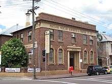
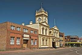 Maitland Town Hall, High Street | |||||||
|
Maitland | |||||||
| Coordinates | 32°43′S 151°33′E / 32.717°S 151.550°ECoordinates: 32°43′S 151°33′E / 32.717°S 151.550°E | ||||||
| Population | 67,132 (2011 census)[1] | ||||||
| • Density | 513.6/km2 (1,330/sq mi) | ||||||
| Established | 1820 | ||||||
| Postcode(s) | 2320 | ||||||
| Elevation | 3 m (10 ft) | ||||||
| Area | 392 km2 (151.4 sq mi)[2] | ||||||
| Time zone | AEST (UTC+10) | ||||||
| • Summer (DST) | AEDT (UTC+11) | ||||||
| Location | |||||||
| LGA(s) | Maitland City Council | ||||||
| Region | Hunter | ||||||
| County | Northumberland | ||||||
| Parish | Maitland | ||||||
| State electorate(s) | Maitland | ||||||
| Federal Division(s) | |||||||
| |||||||
Maitland is a city in the Lower Hunter Valley of New South Wales, Australia and the seat of Maitland City Council, situated on the Hunter River approximately 166 kilometres (103 mi) by road north of Sydney and 35 km (22 mi) north-west of Newcastle. It is on the New England Highway about 17 km (11 mi) from its start at Hexham.
At the 2011 census it had approximately 67,478 inhabitants, spread over an area of 390.2 square kilometres (151 sq mi), with most of the population located in a strip along the New England Highway between the suburbs of Rutherford and Metford respectively. The city centre is located on the right bank of the Hunter River, protected from potential flooding by a levee.
Surrounding areas include the cities of Cessnock and Singleton local government areas.
History
Originally Maitland consisted of three separate towns which arose roughly all around the same time. West Maitland, now just Maitland, was a privately founded town which grew because of its proximity to the river and which today is the commercial centre of the city. The other areas were East Maitland, which was established by the colonial New South Wales government, and Morpeth, another private town founded by Lieutenant Close, a Peninsular War veteran. Each town functioned as if they were separate municipalities.
The name, Maitland, was reported in 1885 to have had its name taken 'from Sir George Maitland, ... Under Secretary for the Colonies, and M.P. for the Borough of Whitchurch, in Hampshire, England'.[4]
The present city was proclaimed in 1945 with the amalgamation of the three local government areas. The city's boundaries have been increased by incorporating parts of other local government areas since then (most notably Kearsley Shire which from 1946 to 1949 was the only local government area in Australia's history to have a Communist majority of councillors).
West Maitland was founded in 1820 close to the tidal reach of the Hunter River where vessels with a shallow draft could navigate. Nearby Morpeth served as the head of navigation for larger ships (later, steamships), and goods would be transhipped upriver to West Maitland on barges and smaller vessels. Originally the route river route between Morpeth and West Maitland was 26 kilometres (16 mi), today after various floods and river course changes this has reduced to just 9 kilometres (5.6 mi).[5]:10
Maitland was therefore the point at which goods were unloaded for, and distributed to, the prosperous riverland of the Hunter Valley. Accordingly, there were large warehouses (some of which still exist) built, which faced onto the main High Street and backed onto the Hunter River. For almost 20 years until the Victorian gold rush, Maitland was the second largest town in Australia. The arrival of the railway from Newcastle in the 1850s, coupled with the increasing silting of the river and larger ships spelt the end of the traditional river traffic.
The first electricity connected in the area was to Maitland Town Hall in 1922, to the Hall's front light.[6]
Belmore Bridge
The first bridge to link West Maitland with what is now the suburb of Lorn was opened in 1869 and named in honour of the then Governor of New South Wales, the 4th Earl of Belmore.[7] Although the bridge proved vital to the city's development, the floods of 1893, 1913 and 1930 began to heighten the need for a new bridge that could withstand periodic flooding. A second Belmore Bridge, designed to withstand the impact of debris during floods, was built adjacent to the 1869 bridge in 1964. The new bridge, which redirected traffic away from St. Andrews Street to a new intersection at the Maitland Court House, is one of the city's three main river crossings.[7]
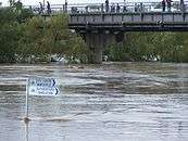
Floods
| Year | Details |
|---|---|
| 1806 | Prior to settlement, but biggest on record. Reports of floodwaters being as high as 24.4 m (80 ft). |
| 1820 | Settlers report finding driftwood in trees 18.9 m (62 ft) above the normal river level. |
| 1832 | Seven killed, floodwaters peak at 8.9 m (29 ft). |
| 1834 | Floodwaters peak at 8.9 m (29 ft). |
| 1857 | Floodwaters peak at 9.2 m (30 ft). |
| 1893 | Extensive flooding destroys homes in Louth Park and Victoria Street. Nine killed. |
| 1913 | Floodwaters inundate central Maitland. Homes are lost on Mount Pleasant Street and in Horseshoe Bend. |
| 1930 | Floodwaters inundate Maitland. |
| 1931 | Floodwaters inundate Maitland. |
| 1949 | Floodwaters invade lower High Street, Maitland. |
| 1951 | Flooding in Maitland. |
| 1952 | Flooding in Maitland. |
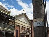
| 1955 | Twenty five killed, 2,180 homes invaded by water. |
| 1971 | Biggest flood on record since 1955. |
| 1998 | Minor flooding in the Maitland district. |
| 2007 | Floodwaters invade suburbs of Maitland; central Maitland escapes flooding. |
| 2015 | Superstorm hits the Hunter, flash-flooding in Maitland. |
Maitland's proximity to the Hunter River has resulted in a succession of floods since European settlement. Over 200 floods have occurred on the Hunter River since settlement, 13 of those higher than the river's normal peak limit of 10.7 metres (35.1 ft). Of these 13, all have had a direct effect on the city of Maitland.[8]
Between 1830 and 1834 Maitland experienced five floods. The 1832 flood was severe with water reaching about 8.84 m (29 ft) and killing seven people. The 1834 flood water reached the same height. In the winter of 1857 the Hunter River rose again to record heights, reaching 9.2 m (30 ft). Flooding continued for the next 30 years with the floods of the 1890s being the most disastrous. Much of the riverbank collapsed and many people were left without homes or personal possessions.[8]
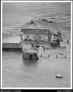
However, the 1940s and 1950s saw an increase in rainfall and the river rose again and again.[8] In February 1955, Maitland and the Hunter Valley experienced its most severe flood in recorded history. The 1955 Hunter Valley floods, also commonly known as "The Maitland Flood", was the first Australian natural disaster to be broadcast by the media on an international scale.[8] This flood is considered to be one of Australia’s worst floods.[9] The waters reached 12.5 m (41 ft) and caused catastrophic damage. The volume of flood water was approximately 3,750,000 megalitres (8.2×10¹¹ imp gal) and the cost of damage, in today’s currency, would have been over A$2 billion. Seven thousand buildings and homes were damaged and the flood claimed the lives of 14 people.
In early June 2007 an intense low pressure system which caused devastating storms to hit the city of Newcastle and the Central Coast also caused major flooding throughout the lower Hunter Region including the Maitland area. During the flooding on 11 June 2007 the Hunter River was expected to reach a peak of 11.3 m (37.1 ft) at Maitland's Belmore Bridge and break levee banks. Some 4000 residents of the suburb of Lorn were evacuated before the floodwaters became stable at 10.7 m (35.1 ft) and did not invade central Matiland.[10] Other areas did not escape with waters inundating homes in Branxton, Louth Park and Raymond Terrace. The flood has been compared to the devastating 1955 Hunter Valley floods.
From 20 to 22 April 2015, heavy rainfall in the Hunter, Central Coast and Sydney regions of New South Wales resulted in flash flooding and extended power outages to over 200,000 homes. Maitland was badly affected and the flood gates at Maitland railway station reinforced with sandbags to prevent flooding in central Maitland.[11] Four people died as a result of the storms and a further four died in traffic related incidents.[12] The towns of Dungog and Gillieston Heights, the homes of the four flood victims, were also badly affected, becoming isolated from other communities.
Jewish Community
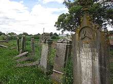
The Maitland Jewish Cemetery in Louth Park, one of only two provincial Jewish cemeteries in New South Wales, is testament to the Jewish community that was active in Maitland up until the 1930s.[13] Between about 1846 and 1934, 53 Jews were buried in the low-lying cemetery. Burials ceased after this time due to dissipation of the community and the cemetery being full. One exception was Lea Abadee in 2010.[14] The city's former synagogue, located on Church Street, was the place of worship for about 70 families between 1879 and 1898.[15]
Climate
Maitland has a warm temperate climate with hot summers and mild winters. It gets 90.3 clear days, annually.
| Climate data for Maitland Visitors Centre | |||||||||||||
|---|---|---|---|---|---|---|---|---|---|---|---|---|---|
| Month | Jan | Feb | Mar | Apr | May | Jun | Jul | Aug | Sep | Oct | Nov | Dec | Year |
| Record high °C (°F) | 44.5 (112.1) |
44.5 (112.1) |
39.7 (103.5) |
34.0 (93.2) |
29.5 (85.1) |
24.6 (76.3) |
24.8 (76.6) |
30.5 (86.9) |
35.2 (95.4) |
38.0 (100.4) |
43.0 (109.4) |
42.2 (108) |
44.5 (112.1) |
| Average high °C (°F) | 30.3 (86.5) |
29.4 (84.9) |
27.5 (81.5) |
24.4 (75.9) |
21.1 (70) |
18.4 (65.1) |
17.9 (64.2) |
19.9 (67.8) |
23.1 (73.6) |
25.3 (77.5) |
26.8 (80.2) |
28.7 (83.7) |
24.4 (75.9) |
| Average low °C (°F) | 18.0 (64.4) |
18.0 (64.4) |
15.9 (60.6) |
12.1 (53.8) |
8.1 (46.6) |
6.3 (43.3) |
5.5 (41.9) |
5.5 (41.9) |
8.2 (46.8) |
11.0 (51.8) |
14.3 (57.7) |
16.3 (61.3) |
11.6 (52.9) |
| Record low °C (°F) | 8.4 (47.1) |
9.8 (49.6) |
7.0 (44.6) |
0.7 (33.3) |
−0.9 (30.4) |
−1.8 (28.8) |
−3.5 (25.7) |
−4.5 (23.9) |
0.0 (32) |
3.0 (37.4) |
3.4 (38.1) |
5.3 (41.5) |
−4.5 (23.9) |
| Average precipitation mm (inches) | 53.2 (2.094) |
53.2 (2.094) |
90.5 (3.563) |
82.6 (3.252) |
62.8 (2.472) |
88.5 (3.484) |
47.4 (1.866) |
30.9 (1.217) |
48.7 (1.917) |
57.6 (2.268) |
83.8 (3.299) |
59.5 (2.343) |
820.1 (32.287) |
| Average precipitation days | 10.8 | 11.6 | 11.4 | 11.9 | 10.6 | 12.9 | 10.3 | 8.1 | 8.4 | 9.1 | 12.3 | 10.4 | 127.8 |
| Source: [16] | |||||||||||||
Economy
Retail
Maitland has many shopping precincts including Stockland Green Hills (East Maitland), (Centro Maitland Hunter Mall) High Street Mall (City Centre), Rutherford, Melbourne Street (East Maitland) and Lawes Street (East Maitland). Morpeth, a suburb of Maitland, is also popular for its fashion boutiques, cafes and speciality shops.
Tourism
Tourism is also a significant local industry. Local attractions include the historic Maitland Gaol, the industrial history of the Walka Water Works, the historic river port town of Morpeth and the Maitland Regional Art Gallery.
Transport
Rail
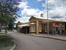
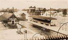
Maitland railway station lies on the Hunter line and is the branch point for the Main North Line and the North Coast Line. Other railway stations in Maitland include:
A passenger tram system ran from East to West Maitland between 1909 and 1926 after which it was replaced by buses which continue to service the route today.
Air
Maitland Airport is a general aviation airfield located beside the New England Highway in Rutherford. Construction was started in 1948 by the now-defunct Maitland Aero Club. In 1957, operation of the airfield transferred to the Royal Newcastle Aero Club (RNAC), which moved from Broadmeadow Aerodrome, its original base of operations, in 1963.
Media
Maitland is serviced by a number of regional newspapers, radio stations and television stations.
The Maitland Mercury and The Newcastle Herald are the foremost newspapers in the city. The Mercury, established in 1843, operates out of offices on High Street and is Australia's oldest regional newspaper.[17] "The Lower Hunter Star" is an adjunct to the "Mercury" and is published every Thursday.[18] With a circulation of almost 20,000, The Lower Hunter Star is delivered to most residents within the City of Maitland. The Hunter Post is published every Wednesday and is distributed to almost 25,000 residents across Maitland and the neighbouring town of Cessnock.
Radio
Radio stations include:
AM stations
- 2HD (commercial)
- 1233 ABC Newcastle (ABC Local Radio)
- 2HRN (off band commercial)
- 2KY Racing Radio (as part of statewide network)
FM stations
- KOFM (commercial)
- NXFM (commercial)
- New FM (commercial)
- 2NUR (community)
- 2CHR (Central Hunter Radio) 96.5 FM – [19] (community)
- Rhema FM Newcastle (Christian)
- Triple J (102.1)
Government broadcasters
- Australian Broadcasting Corporation
- 1233 ABC Newcastle
- ABC Radio National
- ABC News Radio
- Triple J (youth station)
- ABC Classic FM (classical music)
- SBS Radio (foreign language service)
Television
Maitland is part of the Newcastle-Hunter Region television market, which is served by 5 television networks, three commercial and two national services (which include new sub-channels that started in 2009 for the commercial networks and in recent years from the national services). These new channels are available on digital TV only. These networks are listed as follows:
- NBN Television, GEM (digital only) and GO! (digital only) : (Nine Network affiliate, incumbent station, (NBN TV) established 1962).
- Southern Cross Ten, One (digital only) and Eleven (digital only) : (Network Ten affiliate, Southern Cross Ten (formerly known as TEN Northern N.S.W. and NRTV) was established as a result of aggregation on 31 December 1991).
- Prime7 (formerly known as Prime Television), 7Two (digital only) and 7mate (digital only) : (Seven Network / Prime affiliate was established as a result of aggregation on 31 December 1991 but swallowed).
- ABC Television including ABC1, ABC2/ABC 4 Kids (digital only), ABC3 (digital only) and ABC News 24 is owned by the government. The ABC TV service was established in the 1960s.
- SBS Television including SBS ONE and SBS Two (digital only) is owned by the government. This service was introduced in the 1980s.
NBN Television produces an evening news bulletin combining local, state, national and international news screening nightly at 6.00PM, while subscription television service Foxtel is also available via satellite.
Annual events
Hunter Valley Steamfest
Hunter Valley Steamfest is an annual festival celebrating the history of steam power and industry in the Maitland area. It was established in 1986 in response to the closure of the last coal operated steam hauled freight service on the South Maitland Railway network in 1983.[20]
Bitter & Twisted Beer Festival
Bitter & Twisted is an annual international boutique beer festival held at historic Maitland Gaol. It is a celebration of beer, food and music.
ChapelJazz (formerly Morpeth Jazz Festival)
ChapelJazz is an annual music festival held at the popular historic riverside port of Morpeth. It is a celebration of music, wine and food.
Groovin' the Moo
Groovin' the Moo is an annual music festival held at the Maitland Showground since 2006.
Maitland Show
Annual agricultural show held at the Maitland Showground.
Education
Maitland has many training facilities including short course vocational training schools to international standard Phd studies. The Hunter Institute of Technology has a campus in Maitland, as does the privately owned Hunter Valley Training Company (Australia's largest group trainer). These facilities provide excellent training in all fields, especially building and construction, engineering, mining, tourism and business administration. A new technical college is being developed within the city.
Maitland has twenty primary schools and seven high schools. The high schools are:
- All Saints College, St Joseph's Campus
- All Saints College, St Mary's Campus
- All Saints College, St Peter's Campus
- Hunter Valley Grammar School
- Maitland Christian School
- Maitland Grossmann High School(formerly Maitland Girls' High School)
- Maitland High School(formerly Maitland Boys' High School)
- Rutherford Technology High School
- Francis Greenway High School
- St Johns The Baptist Primary School
There are also numerous pre-school and day care facilities and a campus of Hunter Institute of TAFE.
Sport and recreation
- Maitland Off-road Radio Car Club, racing at Harold Gregson Reserve.
- Maitland Pickers rugby league
Maitland is generally accepted to be the birthplace of Motorcycle speedway when New Zealand born promoter Johnny S. Hoskins organised a series of motorcycle races at the West Maitland Showground on Saturday, 15 December 1923.[21]
Notable people
- William Arnott (1827–1901) biscuit manufacturer
- John Bell (1940 -) actor
- David Berthold theatre director
- Greg Bird (1984–) professional rugby league player
- Alexander Brown (1851–1926) merchant and politician
- George Lyndon Carpenter (1872–1948) Salvation Army general
- Caroline Chisholm (1808–1877) philanthropist, sheltered homeless immigrants in a cottage at Maitland
- Percy Brereton Colquhoun (1866–1936) sportsman, lawyer and politician
- Abbie Cornish (1982 -) actress
- Michael Cox (born 1956), cricketer, born in Newcastle, raised in Maitland
- Ruth Cracknell (1925–2002) actress
- Les Darcy (1895–1917) boxer and folk hero
- Edward Davis (1816–1841) "Teddy the Jewboy", Australian convict turned bushranger
- Justin Dooley (1970 -) rugby league player
- Luke Dorn (1982 -) professional rugby league player
- Joseph Wilfrid Dwyer (1869–1939) Roman Catholic Bishop of Wagga Wagga
- Nick Enright (1950–2003) playwright
- H. V. Evatt (1894–1965) Third President of the United Nations General Assembly, Justice of the High Court of Australia, Chief Justice of the Supreme Court of New South Wales
- Clive Evatt (1900–1984) Australian politician, barrister and raconteur
- Allen Fairhall (1909–2006) politician and Member of the Parliament of Australia for the Division of Paterson
- Brett Finch (1981 -) rugby league player
- Michael Scott Fletcher (1868–1947) Methodist minister, foundation master of Wesley College, University of Sydney
- Ben Hall (1837–1865) bushranger
- Harry Holgate (1933–1997) politician and former Premier of Tasmania
- Matt Jobson (1980 -) rugby league player
- Ellis Lawrie (1907–1978) politician
- Frank Liddell (1862–1939) politician
- Edmund Lonsdale (1843–1913) politician
- Charles Macartney (1886–1958) cricketer
- Jack Marx (1965 -) journalist and author
- Charles Stuart Mein (1841–1890) barrister, politician and judge
- Jim Morgan ( -2005) rugby league player
- George Moore (1820–1916), cricketer, born in England, but lived most of his live in Maitland
- Milton Morris (1924 -) politician
- Sir Arthur William Morrow (1903–1977) physician
- Ziggy Niszczot (1955 -) rugby league player
- Walter O'Hearn (1890–1950) politician
- Margaret Olley[22] (1923–2011) painter
- Noel Pidding (1927 -) rugby league player
- Mark Rowe[23] (1943–2011) neuroscientist
- Baker Russell (1837–1911) Australian-born British Army officer
- Henry Chamberlain Russell (1836–1907) astronomer and meteorologist
- David Trewhella (1963 -) rugby league player
- William Samuel Viner (1881–1933) Australian chess master
- Walter Lawry Waterhouse (1887–1969) agricultural scientist
- Alasdair Webster (1934 -) politician
- Leonora Wray (1886–1979) golfer
- Peter Wynn (1957 -) rugby league player
See also
References
- ↑ Australian Bureau of Statistics (31 October 2012). "Maitland (NSW)(Urban Centre/Locality)". 2011 Census QuickStats. Retrieved 12 November 2012.
- ↑ Australian Bureau of Statistics (31 October 2012). "2011 Community Profiles: Maitland (Local Government Area)". 2011 Census of Population and Housing. Retrieved 6 October 2012.
- 1 2 3 "Maitland Visitors Centre". Climate statistics for Australian locations. Bureau of Meteorology. Retrieved 5 July 2009.
- ↑ "The Maitland Mercury & Hunter River General Advertiser (NSW : 1843 - 1893) Thursday 12 February 1885, p.7, Article, THE HUNTER FIFTY YEARS AGO.". Retrieved 12 November 2013.
- ↑ Walsh, Brian; Archer, Cameron (2007). Maitland on the Hunter (2nd ed.). Tocal, NSW: CB Alexander Foundation. ISBN 0-7313-0596-5.
- ↑ George, Peter. The Walka Power Station 1953–1977. Bolwarra, NSW. 1997. P.1.
- 1 2 "BridgePanel" (PDF). Retrieved 9 December 2010.
- 1 2 3 4 "Maitland Area History". Maitland City Council. Archived from the original on 18 April 2008. Retrieved 2 May 2008.
- ↑ "Maitland Flood Fiftieth Anniversary". Parliament of New South Wales. 23 February 2005. Retrieved 28 April 2008.
- ↑ "Central Maitland escapes peak of Hunter flood". News Online. Australian Broadcasting Corporation. 11 June 2007.
- ↑ "Super storm: 4000 sandbags - and SES comes to the rescue". The Maitland Mercury. 23 April 2015.
- ↑ "Mike Baird surveys storm-ravaged Hunter regions still isolated by floodwaters". Nine News. 23 April 2015.
- ↑ "Maitland City Council – Maitland Jewish Cemetery". Maitland.nsw.gov.au. Retrieved 9 December 2010.
- ↑ Benjamin, Henry (9 July 2010). "First burial in Jewish cemetery in 76 years!". J-Wire. Retrieved 9 December 2010.
- ↑ "Jewish Historical Sites in Australia". Jewishhistoryaustralia.net. 22 January 1931. Retrieved 9 December 2010.
- ↑ "Maitland Visitors Centre". Climate statistics for Australian locations. Bureau of Meteorology. Retrieved 4 December 2013.
- ↑ "Maitland Mercury | State Library of New South Wales". State Library of New South Wales. 23 October 2008. Retrieved 9 December 2010.
- ↑ "Rural Press Sales". Rural Press Sales. Retrieved 9 December 2010.
- ↑ "2CHR Central Hunter Community Radio". 2chr.org. Retrieved 12 November 2012.
- ↑ "Home". Hunter Valley Steamfest. Maitland City Council. Retrieved 5 June 2016.
Steamfest was established in 1986 following the closure of the last coal operated steam hauled freight service in Australia on the South Maitland Railway Line in 1983, Steamfest pays homage to the end of an industrial era and the men and women involved in its operation.
- ↑ FIM - History of Track Racing
- ↑ Gregory, Helen (29 July 2011). "Margaret Olley – a treasured original". The Newcastle Herald. Retrieved 12 November 2012.
- ↑ "Scientist cultivated many interests". The Sydney Morning Herald. 27 January 2011. Retrieved 12 November 2012.
External links
| Wikimedia Commons has media related to Maitland, New South Wales. |
- Maitland City Council
- Hunter Region
- History of the Maitland Mercury – State Library of NSW
-
 "Maitland". Collier's New Encyclopedia. 1921.