Ontario Highway 24
| |||||||||||||
|---|---|---|---|---|---|---|---|---|---|---|---|---|---|
| Route information | |||||||||||||
| Maintained by the Ministry of Transportation of Ontario | |||||||||||||
| Existed: | July 2, 1927 – present | ||||||||||||
| Major junctions | |||||||||||||
| South end: |
| ||||||||||||
|
| |||||||||||||
| North end: | South limit of Cambridge | ||||||||||||
| Location | |||||||||||||
| Major cities: | Simcoe, Paris, Brantford, Cambridge | ||||||||||||
| Highway system | |||||||||||||
| |||||||||||||
King's Highway 24, commonly referred to as Highway 24, is a highway in the Canadian province of Ontario that currently begins at Highway 3 in Simcoe, and ends at the southern city limits of Cambridge. Highway 24 runs in a north/south direction and has been in service since 1927. Before 1997, when many major highways were declassified, Highway 24 began south of Simcoe in Norfolk near Walshingham, and ended in Collingwood, as part of Hurontario Street.
Route description

In its present form, Highway 24 begins at Highway 3 in the town of Simcoe. The highway once continued south, but this has since been transferred to local jurisdiction and is now Norfolk County Highway 24. From Simcoe, Highway 24 travels north through Oxford County, bypassing to the east of Scotland as it enters Brant County. From there, it meanders northeast towards Brantford Municipal Airport, intersecting former Highway 53 before encountering an interchange with Highway 403 (Exit 27) south of Paris.
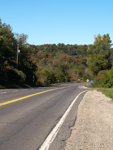
The route joins concurrently with Highway 403 and travels east into Brantford; Highway 24 resumes its northward orientation at the King George Road interchange (Exit 36), splitting from Highway 403. Between Brantford and Cambridge, Highway 24 is a busy two lane rural highway that has played host to frequent collisions, prompting a Ministry of Transportation of Ontario (MTO) investigation into possible upgrades to the stretch. The route is generally straight and flat as it progresses north through the agricultural countryside of Brant County, but suddenly drops into the Grand River Valley as it enters the Regional Municipality of Waterloo. It follows the river along its eastern bank towards Cambridge, ending at the southern city limits.
Within Wellington, Dufferin, Grey and Simcoe counties, the former route of Highway 24 is now designated as County Road 124, while in Waterloo and Peel Regions the route is designated Regional Road 24. This discontinuity has led to motorist confusion, as the route number changes suddenly at boundaries. Within Wellington County, there is also an unrelated County Road 24. The highway is maintained under a Connecting Link agreement in Simcoe and north of Highway 403 in Brantford.[1]
History
Highway 24 was first designated on July 2, 1927, when the Department of Highways (DHO) assumed the road between Simcoe and Brantford as well as the road connecting Paris, Galt (Cambridge) and Guelph as a new provincial highway. In addition, a concurrency was established with Highway 2 between Brantford and Paris.[2] However, on June 4, 1930 a more direct routing between Brantford and Cambridge was established; the route between Paris and Cambridge was renumbered as Highway 24A.[3] On September 9, 1936, the highway was extended south from Simcoe to Lake Erie then east to Highway 6 in Port Dover. This was followed several months later by an extension from Guelph through Erin to the Wellington–Peel county boundary, which was assumed on March 31, 1937.[4]
On August 11, 1937, the DHO designated the Shelburne to Collingwood Road as Highway 24.[5] This left a large gap in the highway, including the terminus near Erin that did not end at a provincial highway. This was remedied eight months later when the DHO assumed several county roads in Peel County (now the Regional Municipality of Peel) on April 13, 1938. This established Highway 24 between the county boundary and Orangeville, via Alton, as well as Highway 51 between Highway 10 in Caledon Village and Coulterville.[6] In addition, Highway 10 and Highway 24 were signed concurrently between Orangeville and Shelburne. In 1965, the segment through Alton was redesignated as Highway 136 as Highway 24 was re-routed along a redesignated Highway 51 towards Highway 10 in that year.
Future
On September 12, 2006, it was announced that the Ontario provincial government would be undertaking a study to determine what improvements would be necessary to bring the highway up to current standards and to handle future growth.
This study (which will be completed in 2009) will focus on the portion of the highway between Cambridge and Brantford, where connections to Highways 401 and 403 exist, but suffer from extreme congestion during peak periods.
Potential improvements/expansions include:
- improving the road surface, lighting and traffic control devices at selected intersections
- widening the road from two to four lanes near urban centres
- complete expansion to a four-lane highway
- construction of a multi-lane, controlled-access freeway
Major intersections
The following table lists the major junctions along Highway 24, as noted by the Ministry of Transportation of Ontario.[1]
| Division | Location | km[1] | mi | Destinations | Notes |
|---|---|---|---|---|---|
| Norfolk | Walsingham | −32.1 | −19.9 | Norfolk County Highway 59 – Port Rowan, Tillsonburg | Decommissioned in 1997 |
| Simcoe | 0.0 | 0.0 | Beginning of Simcoe Connecting Link agreement | ||
| 2.5 | 1.6 | End of Simcoe Connecting Link agreement | |||
| 3.8 | 2.4 | Old Highway 24 – Waterford | |||
| Round Plains | 9.3 | 5.8 | County Road 9 | ||
| Brant | 18.9 | 11.7 | Burford–Delhi Townline Road | ||
| 19.8 | 12.3 | County Road 4 (Vanessa Road) | |||
| Brantford | 31.5 | 19.6 | Brant County Highway 53 (Colborne Street West) | ||
| 36.3 | 22.6 | ||||
| 45.3 | 28.1 | ||||
| Brant | 47.5 | 29.5 | County Road 23 (Powerline Road) | ||
| 49.6 | 30.8 | Brant County Highway 5 west – Paris / Brant County Highway 99 east – Hamilton | Beginning of former Highway 5 concurrency | ||
| 53.1 | 33.0 | County Road 35 west (Blue Lake Road) / Brant County Highway 5 east – Burlington | End of former Highway 5 | ||
| 59.7 | 37.1 | County Road 144 (Lockie Road) | |||
| Waterloo | North Dumfries | ||||
| 64.5 | 40.1 | Cambridge city limits | |||
1.000 mi = 1.609 km; 1.000 km = 0.621 mi
| |||||
References
- 1 2 3 Ministry of Transportation of Ontario (2008). "Annual Average Daily Traffic (AADT) counts". Retrieved February 8, 2012.
- ↑ "Appendix 6 - Schedule of Assumptions and Reversions of Sections". Annual Report (Report). Department of Highways. March 31, 1928. pp. 59–60.
- ↑ "Appendix 5 - Schedule of Assumptions and Reversions of Sections". Annual Report (Report). Department of Highways. March 31, 1931. p. 76.
- ↑ "Appendix 4 - Schedule of Assumptions and Reversions of Sections". Annual Report (Report). Department of Highways. March 31, 1937. p. 51.
- ↑ "Appendix 3 - Schedule of Assumptions and Reversions of Sections". Annual Report (Report). Department of Highways. March 31, 1938. pp. 80–81.
- ↑ "Appendix 3 - Schedule of Assumptions and Reversions of Sections". Annual Report (Report). Department of Highways. March 31, 1939. p. 84.
- Highway 24 expansion
- Highway 24 Corridor Planning and Class EA Study, accessed December 3, 2006
- Legislative Assembly of Ontario: Highway 24, June 15, 2006, question by MPP Dave Levac (Brant), answered by Minister of Transportation Donna Cansfield, accessed 9 October 2007