Permanently signed detour route
A permanently signed detour route (also known as an emergency detour route or emergency diversion route) is a type of route which is used temporarily during special circumstances. Various areas have developed these systems as part of incident management. The purpose of these routes is to provide a detour in the event that the parent route is impassable, due to either a traffic jams, traffic collision, or road closure (for a variety of reasons). Sometimes these routes are signed as a prefixed or suffixed numbered road, making them a type of special route.
A permanently signed detour route should not be confused with a "permanent detour". The latter would be used if a particular roadway section, such as a bridge, were closed permanently.[lower-alpha 1]
Canada
Ontario

The province of Ontario in Canada is one jurisdiction outside the United States with a very prevalent system of these roads. The Emergency Detour Routes, originally Emergency Diversion Routes (EDR), are a system of temporary detour routes paralleling many major highways in Ontario. Most of these follow county or municipal roads within the province that are not (currently) provincially controlled (though many were former provincial highways). These routes are designed to be used in the event of a closure on a major road or 400-series highway, such as construction or serious collisions.
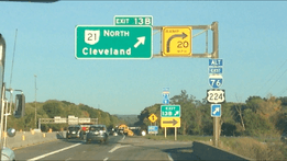
Though most EDRs are set up along 400-series highways, a select few have been established along two lane King's Highways, notably Highway 21 due to the lake effect of Lake Huron, which can result in sudden snowsquall conditions during the winter.
- History
Halton was the first jurisdiction in Ontario to create EDRs, although it initially referred to them as Emergency Diversion Routes. In August 1999, the regional council approved the preparation of the Road Closure Action Plan (RCAP), which was developed with input from the Halton Regional Police Services and the Ministry of Transportation of Ontario (MTO).[2] The RCAP utilized folding signs that police could open to "activate" the route. Similar in appearance to the EDR signs of today, the RCAP signs featured a trapezoid shaped orange EDR sign, as opposed to an orange square with a black circle containing the letters EDR. These signs were first deployed along a limited stretch of the Queen Elizabeth Way in March 2001,[3] between Dorval Drive and Trafalgar Road in Oakville and between Bronte Road and Burloak Drive in Burlington, both the location of major ravines with limited alternative crossings.[4]
By the spring of 2003, when the deployment of the system was complete, the entire Queen Elizabeth Way, Highway 401 and Highway 403 had diversion routes within Halton Region.[2][4] Following Halton's tests, the MTO and the Ontario Good Roads Association formed a joint task force, and using the RCAP as a model, developed the Emergency Detour Route program.[2]
In 2010 and 2011, an aggressive program was instituted to place EDRs alongside major routes throughout the province.[5][6][7][8]
United Kingdom
The United Kingdom uses yellow signs with a series of symbols for its emergency diversion routes.[9]
United States
The national MUTCD has not yet adopted standard signage for these routes. Some states have adopted their own systems.
Michigan

Michigan has a system of special routes called "Emergency" routes which parallel major highways, primarily in Southwestern Michigan. These routes provide relief in the event of emergency closures to a freeway due to accidents, weather, or other civil emergencies. Emergency routes have been gradually put in place as part of a broader plan by the Michigan Department of Transportation (MDOT) to upgrade its ITS network across the state. These detours may or may not follow MDOT-maintained State Highways, however, and some portions of the routes pass through urban or suburban areas.[10] Emergency routes exist on and parallel to Interstate 69 (I-69)[11] and I-94[10] and US Highway 31 (US 31).[12]
These routes are signed with an auxiliary "Emergency" plate that is colored orange, indicating a temporary traffic control sign.
Emergency US 31, which offers an alternative crossing of the Grand River in the event that the bascule bridge in Grand Haven, Michigan is unavailable for motorists,[13] is one such route. According to MDOT, "this route would only be used in emergency situations and worst-case scenarios impacting the entire bridge structure."[13]
Missouri
Missouri uses "Incident By-Pass Routes" along its highways.[14]
Ohio
Ohio has established a permanent detour scenario of Interstate 70, due to frequent flooding.[15]
Interstate 76 and Interstate 77 both have alternate routes in Summit County.
They are the only known instances of freeways having alternate Interstate designations.
Pennsylvania

Pennsylvania has a system of "color detour signs" in which any detour follows signs with a specific color.[16][17][18] The detours are meant to be used if a limited-access highway has to be closed for an emergency situation such as a flood or car accident, directing motorists along local roads near the limited-access highway to the next exit. They are generally color-coded according to direction, with blue meaning north, red meaning south, green meaning east, and orange meaning west. However, other colors are sometimes used when detour routes overlap with one another.[17][19]
West Virginia
The West Virginia Turnpike has a series of lettered detours, first posted in early 2012, along its route.[20][21]
Wisconsin
Wisconsin has "alternate route designations" in various areas of the state.[22]
Notes
References
- ↑ "Trail Status". Great Allegheny Passage. Retrieved July 8, 2013.
- 1 2 3 Murphy, Patrick (February 17, 2004). Ministry of Transportation’s Emergency Detour Route Guidelines and Best Practices Initiative (PDF) (Report). Regional Municipality of Halton. Retrieved September 15, 2011.
- ↑ Legall, Paul (February 9, 2001). "Halton Key to Unlocking Traffic Gridlock; Will Test Redirection Schemes for Other Cities". The Hamilton Spectator. Torstar. p. A02.
|section=ignored (help) - 1 2 Murphy, Patrick (September 25, 2002). Halton Region Road Closure Action Plan (RCAP) Update: Phases 2 and 3 (PDF) (Report). Regional Municipality of Halton. Retrieved September 15, 2011.
- ↑ City of Ottawa. Ottawa Gets Emergency Detour Routes. Accessed on September 15, 2011.
- ↑ Emergency detour routes help drivers get out of park. Accessed on September 15, 2011.
- ↑ United Counties to Establish 401 and 416 Emergency Detour Routes (EDRs). Accessed on September 15, 2011.
- ↑ Emergency Detour Routes Show Drivers the Best Route When the Highways Close. Accessed on September 15, 2011.
- ↑ "Signs and Markings: Direction Signs". Highway Code. Her Majesty's Stationery Office.
- 1 2 "Southwest Region and Portions of University Region Final Regional ITS Deployment Plan (part 2)" (PDF). Michigan Department of Transportation. January 24, 2008. Retrieved July 22, 2012.
- ↑ Schirripa, Nick (January 26, 2010). "I-69 Emergency Route Sign Installation Starts Jan. 26" (Press release). Michigan Department of Transportation. Retrieved February 24, 2010.
- ↑ Terry, Tim (March 11, 2009). "MDOT Installs New Emergency Signs on US 31" (Press release). Michigan Department of Transportation. Retrieved July 22, 2012.
- 1 2 Kohrman, Benjamin (August 19, 2005). "MDOT Establishes US 31/Bascule Bridge Emergency Detour Routes" (Press release). Michigan Department of Transportation. Retrieved August 3, 2012.
- ↑ Engineering Policy Group (June 2007). "Incident By-Pass Route (EM-10) Signing" (PDF). Missouri Department of Transportation. Technical Bulletin Number 2. Retrieved July 8, 2013.
- ↑ District 5 staff. "I-70 Detour for High Water Event between SR37 and SR79" (PDF). Ohio Department of Transportation. Retrieved August 3, 2012.
- ↑ "Red Detour, Black Detour, Green Detour, Blue Detour: What's It All About?" (Press release). Pennsylvania Department of Transportation. October 10, 2000.
- 1 2 Carey, Art (January 11, 2008). "PennDot Targets Tie-Ups with Color". The Philadelphia Inquirer.
- ↑ "Mystery Of New Color-Coded Detour Signs Answered". Philadelphia: WCAU-TV. January 3, 2008. Retrieved July 22, 2008.
- ↑ "PennDOT Detour Signs" (PDF). Pennsylvania Department of Transportation. Retrieved July 22, 2012.
- ↑ Cahill, Samantha (March 23, 2012). "Lewisburg Emergency Detour Signs Highlight Alternate Routes". Lewisburg, WV: WVNS-TV. Retrieved September 10, 2012.
- ↑ HNTB Corporation (December 21, 2011). "West Virginia Turnpike Incident Management: Emergency Traffic Control Plan" (PDF). West Virginia Parkways Authority. pp. 17–25. Retrieved September 18, 2012.
- ↑ Statewide Traffic Operations Center (November 2014). "WisDOT Emergency Traffic Control and Scene Management Guidelines" (PDF). Wisconsin Department of Transportation. pp. 48–49. Retrieved July 28, 2016.