Veterans Memorial Parkway
| |||||||
|---|---|---|---|---|---|---|---|
|
Formerly Airport Road Formerly Highway 100 | |||||||
| Route information | |||||||
| Maintained by City of London | |||||||
| Length: | 9.2 km (5.7 mi) | ||||||
| History: |
Opened in 1977 as a two-lane expressway Widened in 2006 to a modern, at-grade expressway | ||||||
| Major junctions | |||||||
| South end: |
| ||||||
| Hamilton Road, Dundas Street, Oxford Street | |||||||
| North end: |
Huron Street (To be extended to Clarke Road) | ||||||
| Location | |||||||
| Major cities: | London | ||||||
| Highway system | |||||||
| |||||||

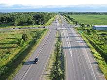
The Veterans Memorial Parkway (VMP, known as "Veterans" by locals) is a 9.2 km (5.7 mi) expressway located in London, Ontario. The expressway was previously known as King's Highway 100 from 1977 until 1994 and as Airport Road from 1977 to September 2006.[1] It is currently an at-grade, four-lane expressway. Long term plans / proposals for the route include north and south extensions of the road and grade separated interchanges along its entire length, converting it to a freeway.[2]
History

In the late 1960s, the highway was conceived by the Ontario government as a freeway bypass that would run along the eastern and northern parts of London. The road would connect to Highway 401 in the south and join up with Highway 402 in the west. This plan, however, never came to fruition due to city council's reluctance to fund an urban freeway.
Instead as a compromise, the City of London and the province decided that the proposed road would be constructed as a two-lane highway from Highway 401 north to Oxford Street. Designed as a super two, the design included a 250-metre-wide (820 ft) right-of-way so that an additional carriageway could be built in the future. As well, the road would be designated as Highway 100 and named Airport Road. The road featured traffic lights at intersections, with available land to build interchanges if warranted. The Hanlon Parkway (also known as Highway 6 North) in Guelph was built around the same time and had similar features as Airport Road, including the same overpass contractors for their trumpet interchanges with Highway 401, and at-grade intersections, although the Hanlon was opened as a four-lane divided road. Construction on Airport Road began in early 1975, with its official opening in 1977.[1]
The Ministry of Transportation downloaded the highway to the city of London and the County of Middlesex in 1994, but has maintained the road as a connecting link.
In 1997, the road was extended further north from Oxford to Huron Street.
In 2004, the City of London began to widen Airport Road from Highway 401 north to Oxford Street, using the right-of-way to construction another carriageway separated by a grass median.[3] The completion of the project resulted in a four-lane, divided highway with room for future interchanges and overpasses, similar to that of the Hanlon Parkway. The widening was completed in late 2005.
In September 2006, the road was renamed Veterans Memorial Parkway as a tribute to Canadian veterans (from World War I, World War II and the Korean War).[4]
During 2010, the Parkway underwent a beautification project. This included a large gateway monument which was installed on the northbound lanes near the Highway 401 interchange, greeting motorists entering the expressway,[5] planting trees along the entire length of the expressway,[6] and raising flagpoles in tribute to Canadian veterans.[7][8]
Future extensions, London Ring Road
London's original ring road was initially planned to be Highbury Avenue, also known as Highway 126, which was opened in 1963.[9] Its exit with Highway 401 is the next one west of Veterans Memorial Parkway. Local opposition resulted in Highbury Avenue's truncation at Hamilton Road.[10]
The City of London has short-term plans to extend Veterans Memorial Parkway to connect with Clarke Road near the Fanshawe Conservation Area. Also, extending Veterans Memorial Parkway south of Highway 401 to Highway 3 in St. Thomas remains a future possibility.
Widening the road between Oxford Street and Huron Street / Robin's Hill Road is also in the city's short term transportation objectives.[11] An environmental study is underway to reconstruct the three-way trumpet interchange with Highway 401 into a four-way interchange that would connect the expressway to Wilton Grove Road and potentially as far south as St. Thomas.[12][13]
In 2007, the City of London conducted an environmental assessment on potential interchange locations to be built along Veterans Memorial Parkway.[14][15] These plans are within a 10-20 year time frame.
The City of London conducted a long-term transportation corridor protection study in 2001 and noted that the Veterans Memorial Parkway (then Airport Road) would serve as the city's eastern expressway when the city reaches its projected full build-out potential.[16]
Long-term plans call for Veterans Memorial Parkway to be included as the eastern leg of a future London Ring Road. These proposals have been discussed since the 1960s and recently have been revived.[17] The eastern corridor for a ring road would use Veterans Memorial Parkway in the east, then continue north along Clarke Road. A western link would start at Highway 402 and head north between Westdel Bourne Road and Woodhull Road.
The northern corridor is a major stumbling block since the lands needed within the city limits have been developed. The only available route possible would be outside of the city in Middlesex Centre. Although talks continue between both municipalities, only the province can approve the plan.
Even if a route for the highway is selected soon, it would not likely be built for 20–30 years.
Future interchanges
The City of London has assessed the entire length of the Veterans Memorial Parkway, identifying areas where interchanges can be constructed, grade separations can occur, and cul-de-sacs (replacing previously at-grade intersections for minor surface roads) can be placed. These changes would upgrade the Veterans Memorial Parkway from a partial control-access expressway to a fully controlled-access freeway for the majority of its length.[18]
| km | mi | Destinations | Notes | ||
|---|---|---|---|---|---|
| Wilton Grove Road | Planned. Extended southern terminus (at-grade intersection). Construction to begin in September 2016. Construction is expected to take up to 2 years to finish. [19] | ||||
| 0 | 0.0 | 4-way interchange planned. Grading underway as of 2015. Construction to begin in 2016 | |||
| 1 | 0.62 | Bradley Avenue (at-grade intersection) | Overpass planned, although a proposal for a parclo interchange is currently under review | ||
| 3 | 1.9 | Hamilton Road (at-grade intersection) | Parclo A-4 interchange planned, alternative designs proposed | ||
| 4 | 2.5 | River Road (at-grade intersection) | Overpass planned | ||
| 5 | 3.1 | Gore Road (at-grade intersection) | Diamond interchange proposed | ||
| 6 | 3.7 | Tartan Drive (at-grade intersection) | Cul-de-sacs proposed | ||
| 6 | 3.7 | Trafalgar Street (at-grade intersection) | Diamond interchange proposed | ||
| 7 | 4.3 | Admiral Drive (at-grade intersection) | Cul-de-sacs proposed | ||
| 7 | 4.3 | Dundas Street (at-grade intersection) | Diamond interchange proposed | ||
| 8 | 5.0 | Page Street (at-grade intersection) | Cul-de-sacs proposed | ||
| 8 | 5.0 | Diamond interchange proposed, access to London International Airport | |||
| 9 | 5.6 | Huron Street (at-grade intersection, highway ends) | Diamond interchange proposed | ||
| Clarke Road | Planned. Extended northern terminus (partial-y interchange) | ||||
1.000 mi = 1.609 km; 1.000 km = 0.621 mi
| |||||
References
- 1 2 Bevers, Cameron. "The King's Highway 100 (#2)". Retrieved November 5, 2010.
The second King's Highway 100 was a staged freeway constructed along the eastern side of London during the 1970s.
- ↑ Green, Doug (October 16, 2006). "Commencement of the Veterans Memorial Parkway Interchange Class Environmental Assessment and Concurrent Notice of Application to Amend the Official Plan & Zoning By-Law" (PDF). Retrieved November 5, 2010.
The City of London proposes to identify interchange locations along the entire length of the Veteran’s Memorial Parkway (formerly Airport Road) corridor.
- ↑ "Transportation Master Plan" (PDF). City of London. May 2004. Retrieved November 30, 2010.
2004 Approved Capital Project: Airport Road widening from 2 to 4 through lanes with new bridge over Thames River and CP Rail, between Highway 401 and Oxford Street.
- ↑ "Veterans Memorial Parkway Dedication Ceremony". City of London. September 15, 2006. Retrieved November 5, 2010.
London's Airport Road was officially renamed Veterans Memorial Parkway in a City ceremony held September 15, 2006.
- ↑ London, ReForest (Spring 2010). "Veterans Memorial Parkway with Scoutrees". Retrieved November 8, 2010.
tributes to our veterans will be erected along Veterans Memorial Parkway
- ↑ Mathyssen, Irene (April 9, 2010). "Making Veterans Memorial Parkway a Fitting Tribute to Our Veterans". Retrieved November 8, 2010.
It was quite a site to see hundreds of volunteers on both sides of the Parkway planting 1,000 trees. An additional 2,000 trees and shrubs were planted in parks throughout the city.
- ↑ "Veterans Memorial Parkway site of flag-raising salute to Canadian Veterans". City of London. November 5, 2010. Retrieved November 8, 2010.
Today’s ceremony included a flag party march, the raising of federal, provincial and territorial flags.
- ↑ "Flag Raising Salute to Canadian Veterans". Elgin Central. November 5, 2010. Retrieved November 8, 2010.
honoured Canadian veterans today at the unveiling of a permanent display of flags on one section of the Veterans Memorial Parkway.
- ↑ Bevers, Cameron. "The King's Highway 126". Retrieved November 27, 2010.
Highway 126 was opened from Highway 401 to Hamilton Road on December 9, 1963.
- ↑ Bevers, Cameron. "The King's Highway 126". Retrieved November 27, 2010.
plans to extend the Highway 126 Freeway further north were eventually scrapped.
- ↑ "Transportation Master Plan" (PDF). City of London. May 2004. Retrieved November 30, 2010.
Airport Road widening from 2 to 4 through lanes from Oxford Street to Huron Street.
- ↑ Transportation division (November 13, 2007). "Veterans Memorial Parkway, Environmental Study, Official Plan and Zoning Amendment" (PDF). City of London. Retrieved April 26, 2010.
Veterans Memorial Parkway: Preferred Alternative to Highway 401/VMP interchange.
- ↑ Transportation division (May 30, 2007). "Veterans Memorial Parkway, Interchange-class environmental assessment study" (PDF). City of London. Retrieved April 26, 2010.
Reformatting the Highway 401/VMP interchange.
- ↑ Green, Doug (May 30, 2007). "City of London Class Environmental Assessment Proposed Official Plan and Zoning By-Law Amendment Veteran's Memorial Parkway (Formerly Airport Road) Notice of Public Information Centre" (Word). Retrieved November 5, 2010.
The anticipated changes to the Official Plan and Zoning By-law include identifying new proposed interchange sites along the Veterans Memorial Parkway corridor
- ↑ Grabowski, Karl (November 13, 2007). "Notice of Public Information Centre No. 2 Veterans Memorial Parkway Interchange Class Environmental Assessment and Concurrent Notice of Application to Amend The Official Plan & Zoning By-Law" (PDF). Retrieved November 5, 2010.
the City intends to proceed with finalizing a report outlining the preferred future road design for the Veterans Memorial Parkway.
- ↑ "London Long Term Transportation Corridor Protection Study" (PDF). City of London. April 5, 2001. Retrieved November 30, 2010.
This study recommends the City protect for a four lane expressway facility along Airport Road from Highway 401 to Sunningdale Road.
- ↑ Cornies, Larry (November 6, 2010). "Ring Road Around London Still a Dream". Retrieved November 8, 2010.
city politicians have tried a few times to revive the ring-road concept, but were twice foiled by the Ontario Municipal Board.
- ↑ "Veterans Memorial Parkway Interchange Class Environmental Assessment Study and Concurrent Application to Amend the Official Plan and Zoning By-Law" (PDF). City of London and Giffels. December 13, 2007. Retrieved November 5, 2010.
The freeway design will reduce the congestion on the road network and improve overall safety while maintaining shorter travel time along the entire corridor to full build out conditions.
- ↑ http://www.lfpress.com/2016/08/04/expressway-extension-to-link-industrial-lands