Ontario Highway 15
| |||||||||||||
|---|---|---|---|---|---|---|---|---|---|---|---|---|---|
| Route information | |||||||||||||
| Length: | 115.4 km[1] (71.7 mi) | ||||||||||||
| Existed: | October 13, 1920[2] – present | ||||||||||||
| Major junctions | |||||||||||||
| South end: |
| ||||||||||||
| North end: |
| ||||||||||||
| Location | |||||||||||||
| Major cities: | Kingston | ||||||||||||
| Towns: | Smiths Falls, Carleton Place | ||||||||||||
| Highway system | |||||||||||||
| |||||||||||||
King's Highway 15, commonly referred to as Highway 15, is a provincially maintained highway in the Canadian province of Ontario. It currently travels north from an interchange with Highway 401 in Kingston to Highway 7 in Carleton Place, but once continued east from there into Ottawa until that section became part of Highway 7. The length of Highway 15 is 113.4 kilometres (70.5 mi).
Highway 15 was one of the original highways created by the province in 1920 to establish a highway network and qualify for funding under the Canada Highways Act. The southern terminus, originally in Seeley's Bay, was moved to Highway 2 in Kingston the following year. The routing of the highway has changed several times over the years, but it continues to serve the same region of Eastern Ontario as it has since 1920.
Route description
Highway 15 begins at an interchange with Highway 401 (Exit 623) in the city of Kingston; it once continued south to former Highway 2 next to CFB Kingston in Barriefield, but this section is now Kingston Regional Road 15. The route travels northeast alongside the Cataraqui River, slicing through Joyceville and passing Joyceville Penitentiary. Over the next several kilometres, the route travels alongside the Rideau Canal, with Locks 43, 44 and 45 a short drive off the highway. After leaving Frontenac County and entering The United Counties of Leeds and Grenville, the route encounters Seeleys Bay, where it curves east and soon meets the northern terminus of former Highway 32. It turns north, then crosses between the municipalities of Leeds and the Thousand Islands and Rideau Lakes at the community of Morton.[3]
After turning northwest and bypassing the community of Elgin, the route encounters the community of Crosby, intersecting former Highway 42 and curving northeast. For the next 30 kilometres (19 mi), the highway travels alongside the Cataraqui Trail,[3] a former Canadian National railway line donated in 1997.[4] It passes through the communities of Portland and Lombardy before entering Smiths Falls and Lanark County, where it intersects former Highway 29 and Highway 43 and turns north. The route crosses the Rideau Canal and proceeds towards Carleton Place alongside the Ottawa Valley Railway, bisecting the communities of Franktown, Beckwith and Black's Corners. On the southern outskirts of Carleton Place, Highway 15 ends at Highway 7, just west of where it becomes a freeway.[3] At one time, Highway 15 travelled concurrently with Highway 7 into downtown Ottawa.
History
Highway 15 was one of the original highways created by the Department of Public Highways, the early predecessor to the Ministry of Transportation of Ontario (MTO). On October 13, 1920, several dirt roads through Leeds and Grenville County and Lanark County were designated as part of the expanding provincial highway network begun a year earlier. The route began in the community of Seeley's Bay and travelled along the current routing of the highway to Smiths Falls. It then turned northwest towards Perth. At Perth, the route turned northeast towards Carleton Place and followed roughly the same alignment as Highway 7 does today. The highway passed through that town and winded towards Ottawa, entering it along Richmond Road and ending in downtown at Highway 17.[2] The following year, the highway was extended south from Seeley's Bay into Kingston to end at Highway 2.[5]
The route was initially unnumbered, but was designated as Highway 15 during the summer of 1925.[6] By that point, the southern terminus was at the present junction of James Street (then Highway 2) and Main Street in Barriefield, north of Fort Henry; the northern terminus was at Carling Avenue (then Highway 17) and Richmond Road.
While the southern section has changed little, Highway 15 has followed several different routings through Lanark County in its history. Originally, there were no Highway 7 markers east of Perth. The existing roads were present, but under a different numbering so what was numbered Highway 15 (originally) would correspond to the following modern designations:
- From Highway 2 Kingston to Smiths Falls, the road uses the current Highway 15 (and Kingston Road 15) route
- From Smiths Falls to Perth, the road followed a route which would later become Highway 43 (now Lanark County Road 43)
- From Perth to Carleton Place and Ottawa, the road corresponds to what is now Highway 7, ending at Highway 17
While a more direct highway route from Smiths Falls to Carleton Place (without a detour westward to Perth) was part of the Ontario highway system, it was numbered as an extension of Highway 29, the current road (Leeds-Grenville road 29) from Brockville to Smiths Falls.
In 1961, the "Highway 7" designator was extended to the entire length of the Peterborough-Perth to Carleton Place/Ottawa highway, removing the "Highway 15" marker from any road through Perth. The '15' designation was moved to the road from Smiths Falls direct to Carleton Place, where it appeared alongside the 'Highway 29' designation (as a concurrency). This left a short road between Smiths Falls and Perth, which would be renumbered as Highway 43 (now Lanark County Road 43).
Beyond Carleton Place, Highway 29 continued north to Arnprior, while the road from Carleton Place to Ottawa was marked concurrently as both Highway 7 and 15.
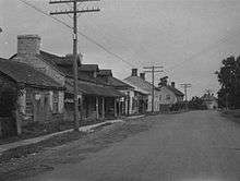
In 1969, a bypass of Barriefield was built, redirecting both Highway 15 and Highway 2 around the historic village.[7]
The next change took place in 1983, when Highway 29 was truncated to Smiths Falls, leaving Highway 15 as the only number on the road from Kingston - Smiths Falls - Carleton Place - Arnprior. The road from Carleton Place to Ottawa would be designated solely as Highway 7 (eliminating both the 15/29 and 15/7 concurrencies).
Prior to 1998, the road's southern terminus was at Highway 2, east of downtown Kingston (at CFB Kingston), while the northern terminus reached Arnprior. Today, the Carleton Place to Arnprior segment is Lanark County Road 29, which matches the route's original (pre-1983) MTO route number.
Major intersections
The following table lists the major junctions along Highway 15, as noted by the Ministry of Transportation of Ontario.[1]
| Division | Location | km[1] | mi | Destinations | Notes |
|---|---|---|---|---|---|
| Kingston | −6.4 | −4.0 | |||
| 0.0 | 0.0 | Exit 623 | |||
| 1.4 | 0.87 | County Road 21 (Kingston Mills Road) | |||
| 13.6 | 8.5 | County Road 13 (Sandhill Road) | |||
| Leeds and Grenville | Leeds and the Thousand Islands | 30.8 | 19.1 | County Road 32 | Former Highway 32 |
| 31.9 | 19.8 | County Road 33 (Lyndhurst Road) | |||
| Crosby | 51.7 | 32.1 | County Road 42 – Newboro | Former Highway 42 | |
| Rideau Lakes | 66.7 | 41.4 | County Road 5 | ||
| Lombardy | 76.1 | 47.3 | County Road 1 | ||
| Lanark | Smiths Falls | 84.4– 89.1 | 52.4– 55.4 | ||
| Franktown | 104.7 | 65.1 | Road 10 (Richmond Road & Perth Road) | Richmond Road continues east towards downtown Ottawa as various Ottawa Regional Roads. | |
| Carleton Place | 115.4 | 71.7 | Beginning of former Highway 7 concurrency | ||
| 116.0 | 72.1 | End of former Highway 7 concurrency | |||
| Ottawa | 154.9 | 96.3 | Decommissioned January 1, 1998; redesignated as Lanark County / Ottawa Regional Road 29 | ||
| Renfrew | Arnprior | 156.7 | 97.4 | Arnprior town limits | Decommissioned April 1, 1997 |
1.000 mi = 1.609 km; 1.000 km = 0.621 mi
| |||||
References
- 1 2 3 Ministry of Transportation of Ontario (2008). "Annual Average Daily Traffic (AADT) counts". Retrieved February 4, 2012.
- 1 2 "Provincial Highways Assumed in 1920". Annual Report (Report). Department of Public Highways. December 1, 1920. pp. 40, 42.
- 1 2 3 Ontario Back Road Atlas (Map). Cartography by MapArt. Peter Heiler. 2010. pp. 36–37, 49, 65. § T56–D60. ISBN 978-1-55198-226-7.
- ↑ "Cataraqui Trail". Frontenac Arch Biosphere. Retrieved January 9, 2014.
- ↑ "System of Provincial Highways Assumed to November 30, 1921". Annual Report (Report). Department of Public Highways. December 1, 1921. p. 28.
- ↑ "Provincial Highways Now Being Numbered". The Canadian Engineer. Monetary Times Print. 49 (8): 246. August 25, 1925.
Numbering of the various provincial highways in Ontario has been commenced by the Department of Public Highways. Resident engineers are now receiving metal numbers to be placed on poles along the provincial highways. These numbers will also be placed on poles throughout cities, towns and villages, and motorists should then have no trouble in finding their way in and out of urban municipalities. Road designations from "2" to "17" have already been allotted...
- ↑ "The Creation of Barriefield Village" (PDF). The Barriefield Village Association. Retrieved June 27, 2012.