Ontario Highway 11
| ||||
|---|---|---|---|---|
| Route information | ||||
| Maintained by the Ministry of Transportation of Ontario | ||||
| Length: | 1,784.9 km[1] (1,109.1 mi) | |||
| Existed: | 1920 – present | |||
| Major junctions | ||||
| South end: |
| |||
|
| ||||
| West end: |
| |||
| Location | ||||
| Divisions: | Simcoe County, Muskoka, Parry Sound District, Nipissing District, Timiskaming District, Cochrane District, Thunder Bay District, Rainy River District | |||
| Major cities: | Barrie, Orillia, North Bay, Temiskaming Shores, Thunder Bay | |||
| Towns: | Gravenhurst, Bracebridge, Huntsville, Burk's Falls, South River, Powassan, Temagami, Englehart, Matheson, Cochrane, Kapuskasing, Hearst, Longlac, Geraldton, Nipigon, Fort Frances, Rainy River | |||
| Highway system | ||||
| ||||
King's Highway 11, commonly referred to as Highway 11, is a provincially maintained highway in the Canadian province of Ontario. At 1,784.9 kilometres (1,109.1 mi), it is the second longest highway in the province, following Highway 17. Highway 11 begins at Highway 400 in Barrie, and arches through northern Ontario to the Ontario–Minnesota border at Rainy River via Thunder Bay; the road continues as Minnesota State Highway 72 across the Baudette-Rainy River International Bridge. North and west of North Bay, Highway 11 forms part of the Trans-Canada Highway. The highway is also part of MOM's Way between Thunder Bay and Rainy River.
Although many of the roads that make up the route were constructed before the highway was designated, Highway 11 became a provincial highway in 1920 when the network was formed. At the time, it only extended to north of Orillia. In 1937, the route was extended to Hearst, northwest of Timmins. The route was extended to Nipigon by 1943. In 1965, Highway 11 was extended to Rainy River, bringing it to its maximum length. The section through Barrie and south to Toronto was decommissioned as a provincial highway in 1998. Since then, ongoing construction resulted in the highway being four-laned as far north as North Bay by 2012. A section concurrent with Highway 17 was rebuilt as a divided highway in the early 2010s, while construction of a twin-span bridge at Nipigon is underway.
History
Predecessors
The earliest established section of Highway 11 is Yonge Street, though it is no longer under provincial jurisdiction. Yonge Street was built under the order of the first Lieutenant-Governor of Upper Canada (now Ontario), John Graves Simcoe. Fearing imminent attack by the United States, he sought to create a military route between York (now Toronto) and Lake Simcoe. In doing so, he would create an alternative means of reaching the upper Great Lakes and the trading post at Michilimackinac, bypassing the American border.
In late 1793, Simcoe determined the route of his new road. The following spring, he instructed Deputy Surveyor General Augustus Jones to blaze a small trail marking the route.[2] Simcoe initiated construction of the road by granting land to settlers, who in exchange were required to clear 33 feet (10 m) of frontage on the road passing their lot.[3] In the summer of 1794, William Berczy was the first to take up the offer, leading a group of 64 families north-east of Toronto to found the town of German Mills, in modern Markham. By the end of 1794, Berczy's settlers had cleared the route around Thornhill. However, the settlement was hit by a series of setbacks and road construction stalled.
Work on the road resumed in 1795 when the Queen's Rangers took over. They began their work at Eglinton Avenue and proceeded north, reaching the site of St. Albans on February 16, 1796. Expansion of the trail into a road was a condition of settlement for farmers along the route, who were required to spend 12 days a year to clear the road of logs, subsequently removed by convicted drunks as part of their sentence. The southern end of the road was in use in the first decade of the 19th century, and became passable all the way to the northern end in 1816.[4]
For several years the Holland River and Lake Simcoe provided the only means of transportation; Holland Landing was the northern terminus of Yonge Street. The military route to Georgian Bay prior to, and during the War of 1812, crossed Lake Simcoe to the head of Kempenfelt Bay, then by the Nine Mile Portage to Willow Creek and the Nottawasaga River. The Penetanguishene Military Post was started before the war. However, lacking a suitable overland transport route, passage from York to Lake Huron continued via the Nottawasaga. The Penetanguishene Road, begun in 1814, replaced this route by the time the military post was opened in 1817.[5]
In 1824, work began to extend Yonge Street to Kempenfelt Bay near Barrie. A north-western extension was branched off the original Yonge Street in Holland Landing and ran into the new settlement of Bradford before turning north towards Barrie. Work was completed by 1827, making connections with the Penetanguishene Road. A network of colonization roads built in the 1830s (some with military strategy in mind) pushed settlement northeast along the shores of Lake Simcoe and north towards the shores of Georgian Bay. By 1860 the Muskoka Road penetrated the southern skirts of the Canadian Shield, advancing towards Lake Nipissing. Further extensions into Northern Ontario would await the arrival of the automobile, and consequent need for highway networks.

Assumption and construction
In order to be eligible for federal funding, Ontario's Department of Public Highways established a network of provincial highways on February 26, 1920. What would become Highway 11 was routed along Yonge Street, its extension to the Penetanguishene Road, and the Muskoka Road as far as the Severn River.[6] It received its numerical designation in the summer of 1925.[7]
Highway 11 was initially planned as a trunk road to connect the communities of Southern Ontario to those of Northern Ontario, as a continuous route from Toronto to North Bay. In 1919, Premier of Ontario Ernest Charles Drury created the Department of Public Highways, though much of the responsibility for establishing the route he left to minister of the new cabinet position, Frank Campbell Biggs. By linking together several previously built roads such as Yonge Street, Penetanguishene Road, Middle Crossroad and the Muskoka Road, all early colonization roads in the region, a continuous route was created between Toronto and North Bay; however, the new department's jurisdiction did not extend north of the Severn River. Roads north of that point were maintained by the Department of Northern Development.
Further expansion was planned with a new highway from North Bay to Cochrane. Construction began in 1925, including reconstruction of portions of the old Muskoka Road from Severn Bridge which was officially opened on July 2, 1927. When it was opened, it was named the Ferguson Highway, in honour of Premier George Howard Ferguson (Drury's successor). This road was extended to Hearst over the next several years.
On April 1, 1937, the DND and DHO merged, and numerous roads north of the Canadian Shield were assumed as provincial highways.[8] As a result of this, Highway 11 was extended to Hearst via North Bay and the Ferguson Highway; it was now 1,024.0 kilometres (636.3 mi) long.[9] Around this time, construction began on a road to connect Highway 17 at Nipigon with the gold mines discovered near the town of Geraldton several years earlier; it was completed in 1939.[10] With the onset of World War II, the need for an east–west connection across Canada became imperative, and construction began on a link between Geraldton and Hearst, a distance of 250 kilometres (160 mi). Upon completion in 1943, Highway 11 was extended to Nipigon, and was now 1,398.0 kilometres (868.7 mi) long.
The route remained this way until the late 1950s, when construction of a new highway west from Thunder Bay towards Fort Frances began. Initially this road was designated as Highway 120. In 1959, it was instead decided to make this new link a westward extension of Highway 11. On April 1, 1960, Highway 11 assumed the route of Highway 120; this consequently created a concurrency of Highway 11 and 17 between Nipigon and west of Thunder Bay.[11][12][13] Now reaching as far as Atikokan, construction of a road between there and Fort Frances was carried out over the next five years. The final link, the 5.6 kilometres (3.5 mi) Noden Causeway over Rainy Lake, was opened on June 28, 1965.[14] Highway 11 was now at it peak length of 1,882.2 kilometres (1,169.5 mi).[15]
Downloading and changes since
In 1997, the care (or rescinding of connecting link agreements) of the highway from Barrie southwards including Yonge Street, was transferred by the provincial government to county, regional, and city governments as part of significant cost reductions by the Ministry of Transportation of Ontario. This practice is called downloading, in that the financial burden will fall to a lower tier government; this is often used when a stretch of road lost its regional importance and it is improper to ask other taxpayers in other regions to pay for this road from which they derive no benefit. Along with the name Yonge Street, the section in York Region is now York Regional Road 1, the section in Simcoe County is now mostly Simcoe County 4. Within the city of Toronto, which does not have a regional road numbering system, it is now known simply as Yonge Street. Highway 11 consequently assumed the 1.1-kilometre highway stub formerly known as Highway 400A, and now ends at the interchange with Highway 400 just north of Barrie's city limits.
In 2003, a major bridge failure at the Sgt. Aubrey Cosens VC Memorial Bridge at the Montreal River in Latchford caused a complete closure and significant detour.
Highway 11 began to be upgraded beginning in the 1960s when the stretch between Barrie and Gravenhurst was upgraded to a 4 lane highway with a median barrier and right-in/right-out ramps, with a signed speed limit of 90 km/h. Upgrades continued in the 1970s between Gravenhurst and Huntsville, where the highway was built with a grass median and a mix of interchanges and at grade intersections. Major reconstruction of Highway 11 between North Bay and Huntsville began in 2003, upgrading the route from a two-lane rural highway to a four-lane road. In some sections the route was being built as an expressway with right-in/right-out ramps or at-grade intersections, while in others it was built as a full 400-Series freeway.
Highway 11 crosses the 45th parallel (halfway between the equator and north pole) 600 metres north of the bridge carrying Highway 118 at interchange 182, just outside Bracebridge.
Due to a steep incline as it descends Thibeault Hill into North Bay, the southbound Algonquin Avenue segment of Highway 11 features the only runaway truck ramp on Ontario's highway system.[16] The Ministry of Transportation is currently undertaking a study of potential highway improvements in the North Bay area, which may include a new westerly realignment of this segment to bypass the hill.
On August 9, 2012, construction of the fully divided four lane freeway between Huntsville and North Bay was completed.[17] However, as the section south of Gravenhurst is still a RIRO expressway rather than a full freeway, and the section between Gravenhurst and Huntsville has not yet had all at-grade intersections removed, the highway is not currently slated to be renumbered as Highway 411.
Route description
Highway 11 varies between a divided four lane urban freeway and a two lane rural road. It travels through surroundings ranging from cities, to farmland, to uninhabited wilderness. The section through northern Ontario includes several sections with no gas or service for over 160 kilometres (100 mi). Significant urban centres serviced by the route include Barrie, Orillia, Gravenhurst, Bracebridge, Huntsville, North Bay, Temiskaming Shores, Cochrane, Hearst, Nipigon, Thunder Bay, Atikokan, Fort Frances and Rainy River.

Barrie – North Bay
Between Barrie and North Bay, Highway 11 is a four lane highway with few at-grade intersections. Although a majority of the route is built to 400-series standards, the sections between Barrie and Orillia as well as between Orillia and Gravenhurst feature Right-in Right-out (RIRO) ramps rather than interchanges.
Highway 11 begins at an interchange with Highway 400 on the north side of Barrie, travelling northeast parallel to the northwestern shore of Lake Simcoe. The four lane route, divided by a median barrier, crosses former Highway 93 (Penetanguishene Road) and passes through a generally-flat rural area, though businesses line both sides of the route. At the northern end of Lake Simcoe, the highway enters Orillia, where it is built as a divided freeway. It meets and becomes concurrent with Ontario Highway 12 for 2.4 kilometres (1.5 mi). At Laclie Drive, the route exits Orillia and returns to a RIRO design with rural surroundings. It travels northward along the western shore of Lake Couchiching as far as Washago, then crosses the Severn River / Trent Severn Waterway.
North of the Severn River, Highway 11 travels through the Canadian Shield; large granite outcroppings are frequent and thick Boreal forest dominates the terrain. At Gravenhurst, the highway makes a sharp curve to the east then becomes a divided freeway before curving northward around Gull Lake. Near Bracebridge, it meets Highway 118 and former Highway 117. Highway 141 branches west from the route between Bracebridge and Huntsville, while Highway 60 branches east towards Algonquin Park in Huntsville.
The 120-kilometre (70 mi) section of Highway 11 between Huntsville and North Bay provides access to the western side of Algonquin Park. It also connects to Highway 518 at Emsdale, Highway 520 at Burk's Falls, Highway 124 at Sundridge and South River, Highway 522 at Trout Creek, Highway 534 at Powassan, and Highway 94 and Highway 654 at Callander.
Nipigon – Rainy River

Business routes
Highway 11B is the designation for business routes of Highway 11, nine of which have existed over the years. Two continue to exist today, while the remaining seven have been decommissioned. With the exception of the short spur route into Atikokan, all were once the route of Highway 11 prior to the completion of a bypass alignment. All sections of Highway 11B have now been decommissioned by the province with the exception of the Atikokan route and the southernmost section of the former Tri-Town route between Cobalt and Highway 11.
In 1967, a section of the Cobalt route of Highway 11B collapsed into an abandoned mine, cutting off the town of Cobalt.[18]
- Holland Landing
- Orillia
- Gravenhurst
- Huntsville
- Powassan
- North Bay
- Cobalt/Temiskaming Shores
- Thunder Bay
- Atikokan
Future
Highway 11 between Barrie and Gravenhurst is currently a right-in/right-out (RIRO) expressway (local access permitted, turnarounds via special interchanges), except for a section around Orillia which is a full freeway. Another freeway section (formerly Highway 400A) does exist in Barrie with the freeway segment from the southern terminus ending at Penetanguishene Road (Simcoe Road 93). The MTO is currently planning on either converting the existing RIRO expressway to a full six-lane freeway, or bypassing it with an entirely new alignment. An environmental and fiscal study concluded that the improvements from Barrie to Gravenhurst will involve the existing route being widened with the exception of a portion south of Gravenhurst that may potentially be constructed to the east of the current road.[19]
Major intersections
The following table lists the major junctions along Highway 11, as noted by the Ministry of Transportation of Ontario.[1] Interchanges are numbered between Barrie and North Bay.
| Division | Location | km[1] | mi | Exit | Destinations | Notes | |
|---|---|---|---|---|---|---|---|
| Simcoe | Oro-Medonte | 0.0 | 0.0 | County Road 93 north (Penetanguishene Road) – Midland | Continuation of Ontario Highway 400 kilometre markers | ||
| 5.7 | 3.5 | Oro-Medonte Line 4 | |||||
| 15.8 | 9.8 | ||||||
| Orillia | 23.6 | 14.7 | 129 | Memorial Avenue | Northbound exit only; southbound exit and northbound entrance via Oro-Medonte Line 15 | ||
| 25.3 | 15.7 | 131 | Beginning of Highway 12 concurrency | ||||
| 27.7 | 17.2 | 133 | End of Highway 12 concurrency | ||||
| 29.8 | 18.5 | 135 | |||||
| 31.4 | 19.5 | Laclie Street | Northbound entrance and southbound exit | ||||
| Severn | 38.9 | 24.2 | Bayou Road / New Brailey Line | ||||
| 46.7 | 29.0 | County Road 169 south | |||||
| 49.0 | 30.4 | ||||||
| Muskoka | Gravenhurst | ||||||
| 64.9 | 40.3 | 169 | District Road 169 west (Muskoka Road) – Bala, Parry Sound | Dead Man's Curve; no northbound entrance | |||
| 69.9 | 43.4 | 175 | District Road 41 west (Bethune Road) District Road 6 east (Doe Lake Road) | ||||
| 76.8 | 47.7 | 182 | District Road 118 west – Bracebridge, Port Carling | ||||
| Bracebridge | |||||||
| 78.8 | 49.0 | 184 | District Road 37 (Fredrick Street / Cedar Lane) | ||||
| 83.6 | 51.9 | 189 | District Road 42 (Taylor Road) | ||||
| 87.5 | 54.4 | 193 | District Road 117 east – Dorset | ||||
| Huntsville | 101.8 | 63.3 | 207 | District Road 10 – Port Sydney | |||
| 114.3 | 71.0 | 219 | District Road 3 (Aspdin Road / Main Street) | Huntsville Bypass | |||
| 116.6 | 72.5 | 221 | District Road 2 (West Road / Ravenscliffe Road) | ||||
| 118.3 | 73.5 | 223 | |||||
| 121.5 | 75.5 | 226 | District Road 3 | ||||
| 235 | Emsdale Bypass | ||||||
| Parry Sound | Emsdale | 244 | Fern Glen Road west / Scotia Road east / Emsdale Road – Kearney | ||||
| 248 | |||||||
| 252 | Doe Lake Road west / Three Mile Lake Road east | ||||||
| Burk's Falls | 152.6 | 94.8 | 257 | Burk's Falls Bypass | |||
| 156.2 | 97.1 | 261 | Ontario Street / Pickerel & Jack Lake Road – Magnetawan | ||||
| Sundridge | 171.6 | 106.6 | 276 | Sundridge / South River Bypass | |||
| South River | 178.7 | 111.0 | 282 | Machar Strong Boundary Road / Mountainview Road / Tower Road – Sundridge | |||
| 184.2 | 114.5 | 289 | |||||
| Laurier | 189.2 | 117.6 | 294 | Goreville Road / Summit Road | |||
| Trout Creek | 196.6 | 122.2 | 301 | Trout Creek Bypass | |||
| 201.4 | 125.1 | 306 | Highway 522B – Port Loring | ||||
| Powassan | 211.9 | 131.7 | 316 | ||||
| Callander | 224.9 | 139.7 | 329 | Highway 654 (Lake Nosbonsing Road) – Nipissing | To | ||
| Nipissing | North Bay | 234.0 | 145.4 | 338 | Lakeshore Drive | Formerly Highway 11B | |
| 239.7 | 148.9 | 344 | Beginning of Highway 17 North Bay concurrency | ||||
| 240.9 | 149.7 | Highway 17B west (Fisher Street) | |||||
| 241.5 | 150.1 | Cassells Street west | |||||
| 243.8 | 151.5 | Highway 11B south (Algonquin Avenue) Airport Road | End of Highway 17 North Bay concurrency | ||||
| Marten River | 300.9 | 187.0 | |||||
| Timiskaming | Gillies | 380.4 | 236.4 | Highway 11B east – New Liskeard Beginning of Tri-Town Bypass | |||
| Temiskaming Shores | 389.9 | 242.3 | |||||
| 396.6 | 246.4 | Beginning of Highway 65 concurrency | |||||
| 399.3 | 248.1 | End of Highway 65 concurrency | |||||
| 411.1 | 255.4 | ||||||
| 417.1 | 259.2 | ||||||
| Earlton | 426.0 | 264.7 | |||||
| Heaslip | 434.7 | 270.1 | |||||
| Englehart | 440.9 | 274.0 | |||||
| 459.6 | 285.6 | ||||||
| 478.6 | 297.4 | ||||||
| Kenogami Lake | 479.6 | 298.0 | |||||
| 493.5 | 306.6 | ||||||
| Cochrane | 521.1 | 323.8 | |||||
| Matheson | 535.6 | 332.8 | Beginning of Highway 101 concurrency | ||||
| 542.0 | 336.8 | End of Highway 101 concurrency | |||||
| 556.3 | 345.7 | ||||||
| 556.6 | 345.9 | ||||||
| Porquis Junction | 569.0 | 353.6 | |||||
| Nellie Lake | 575.9 | 357.8 | |||||
| Cochrane | 615.5 | 382.5 | |||||
| 625.0 | 388.4 | Highway 636 north – Frederick | |||||
| 633.5 | 393.6 | Highway 668 north – Hunta | |||||
| Driftwood | 644.1 | 400.2 | |||||
| Smooth Rock Falls | 670.1 | 416.4 | Highway 634 north – Fraserdale, Abitibi Canyon | ||||
| Moonbeam | 712.6 | 442.8 | |||||
| Kapuskasing | 727.3– 738.2 | 451.9– 458.7 | Kapuskasing Connecting Link | ||||
| Hearst | 829.4 | 515.4 | |||||
| 830.0 | 515.7 | 6th Street | Beginning of Hearst Connecting Link | ||||
| 830.6 | 516.1 | ||||||
| 831.8 | 516.9 | 15th Street | End of Hearst Connecting Link | ||||
| 865.0 | 537.5 | Highway 663 north – Calstock | |||||
| 893.8 | 555.4 | Highway 631 south – White River | |||||
| Thunder Bay | Greenstone | 1,025.9 | 637.5 | Highway 625 south – Caramat | |||
| 1,074.9 | 667.9 | ||||||
| 1,130.5 | 702.5 | ||||||
| 1,153.1 | 716.5 | ||||||
| Nipigon | 1,232.3 | 765.7 | Beginning of Highway 17 Thunder Bay concurrency | ||||
| 1,236.3 | 768.2 | ||||||
| 1,244.7 | 773.4 | Highway 628 east – Red Rock | |||||
| 1,260.2 | 783.1 | ||||||
| 1,264.5 | 785.7 | ||||||
| 1,300.8 | 808.3 | ||||||
| 1,330.8 | 826.9 | ||||||
| Thunder Bay | 1,334.6 | 829.3 | Highway 17B / Highway 11B south (Hodder Avenue) | ||||
| 1,341.0 | 833.3 | ||||||
| 1,347.0 | 837.0 | Harbour Expressway east | |||||
| 1,359.2 | 844.6 | ||||||
| 1,368.6 | 850.4 | ||||||
| Kakabeka Falls | 1,374.9 | 854.3 | |||||
| 1,390.1 | 863.8 | ||||||
| Shabaqua Corner | 1,411.1 | 876.8 | End of Highway 17 Thunder Bay concurrency | ||||
| Shebandowan | 1,431.9 | 889.7 | |||||
| Rainy River | 1,517.9 | 943.2 | Highway 633 – Quetico Centre | ||||
| 1,524.9 | 947.5 | Highway 623 north (Sapawe Road) – Shapawe | |||||
| 1,546.4 | 960.9 | Highway 11B north – Atikokan | To Highway 622 | ||||
| 1,662.1 | 1,032.8 | ||||||
| Fort Frances | 1,688.3 | 1,049.1 | |||||
| 1,690.9 | 1,050.7 | Beginning of Highway 71 concurrency | |||||
| 1,692.9 | 1,051.9 | Highway 602 south | |||||
| 1,696.9 | 1,054.4 | ||||||
| 1,702.1 | 1,057.6 | Highway 611 south | Beginning of Highway 611 concurrency | ||||
| 1,704.1 | 1,058.9 | Highway 611 north | End of Highway 611 concurrency | ||||
| Devlin | 1,713.9 | 1,065.0 | Highway 613 north | ||||
| Emo | 1,726.6 | 1,072.9 | Highway 602 south | ||||
| | 1,732.8 | 1,076.7 | End of Highway 71 concurrency | ||||
| Stratton | 1,751.7 | 1,088.5 | Highway 617 north | ||||
| Pinewood | 1,763.5 | 1,095.8 | Highway 619 north | ||||
| 1,773.1 | 1,101.8 | Highway 621 north – Gameland | |||||
| Rainy River | 1,782.0 | 1,107.3 | Beginning of Rainy River Connecting Link | ||||
| 1,784.6 | 1,108.9 | End of Rainy River Connecting Link | |||||
| 1,784.9 | 1,109.1 | ||||||
1.000 mi = 1.609 km; 1.000 km = 0.621 mi
| |||||||
Route map
.png)
.png)
Images
 Highway 11 just north of North Bay. On the left the Brake Check area can be seen before trucks head into North Bay.
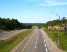
 New 4-lane divided highway at North Waseosa Lake Road/Rockhaven Road interchange near Melissa.
 Winter can pose serious driving hazards along Hwy 11 (near Temagami).
 New 4-lane divided Hwy 11 (near Katrine).
See also
- Webers, a fast-food restaurant located alongside the highway, near Orillia
References
- 1 2 3 Ministry of Transportation of Ontario (2010). "Annual Average Daily Traffic (AADT) counts". Retrieved March 3, 2016.
- ↑ The Road through Richmond Hill
- ↑ Peppiatt, Liam. "Chapter 16: The Children's Friend". Robertson's Landmarks of Toronto Revisited. Retrieved March 5, 2016.
- ↑ Yonge Street's History
- ↑ A History of Simcoe County, (1909) by Andrew F Hunter. Volume 1
- ↑ Shragge, John; Bagnato, Sharon (1984). From Footpaths to Freeways. Ontario Ministry of Transportation and Communications, Historical Committee. pp. 71–75. ISBN 0-7743-9388-2.
- ↑ "Provincial Highways Now Being Numbered". The Canadian Engineer. Monetary Times Print. 49 (8): 246. August 25, 1925.
Numbering of the various provincial highways in Ontario has been commenced by the Department of Public Highways. Resident engineers are now receiving metal numbers to be placed on poles along the provincial highways. These numbers will also be placed on poles throughout cities, towns and villages, and motorists should then have no trouble in finding their way in and out of urban municipalities. Road designations from "2" to "17" have already been allotted...
- ↑ Shragge, John; Bagnato, Sharon (1984). From Footpaths to Freeways. Ontario Ministry of Transportation and Communications, Historical Committee. p. 73. ISBN 0-7743-9388-2.
- ↑ Ontario Road Map (Map). Cartography by D. Barclay. Ontario Department of Highways. 1938–39. § Mileage Tables.
- ↑ Lavoie, Edgar J. (October 2006). "History". Municipality of Greenstone. Retrieved March 4, 2016.
- ↑ Ontario Road Map (Map). Cartography by C.P. Robins. Ontario Department of Highways. 1959. Northern portion inset. § F4–H6.
- ↑ Ontario Road Map (Map). Cartography by C.P. Robins. Ontario Department of Highways. 1960. Northern portion inset. § F4–H6.
- ↑ Information Section (November 9, 1959). "[No title]" (Press release). Department of Highways.
- ↑ http://www.fftimes.com/100-years-100-stories/causewayphoto.html
- ↑ Provincial Highways Distance Table. Ministry of Transportation of Ontario. 1989. pp. 27–32. ISSN 0825-5350.
- ↑ "Northern Highways Program: 2010–2014. Ontario Ministry of Transportation.
- ↑ "Highway 11 four-laning complete". North Bay Nugget, August 10, 2012.
- ↑ Looker, Janet (2000). Disaster Canada. Lynx Images. p. 57. ISBN 1-894073-13-4.
- ↑
External links
| Wikimedia Commons has media related to Ontario Highway 11. |
- Ontario Plaques – Ferguson Highway
- Ontario Highway 11 Homepage – A Virtual Community-by-Community Trip Along the World's Longest Street
- Highway 11 @ AsphaltPlanet.ca
| British Columbia | ||
|---|---|---|
| Alberta | ||
| Saskatchewan | ||
| Manitoba | ||
| Ontario | ||
| Quebec | ||
| New Brunswick | ||
| Prince Edward Island | ||
| Nova Scotia | ||
| Newfoundland | ||
| ||