Ontario Highway 420
| ||||
|---|---|---|---|---|
| Niagara Veterans Memorial Highway | ||||
|
Highway 420 within Southern Ontario | ||||
| Route information | ||||
| Length: | 3.3 km[1] (2.1 mi) | |||
| History: |
November 1, 1941 (as Queen Elizabeth Way) 1972 (as Highway 420) | |||
| Highway 420 | ||||
| West end: |
| |||
| Major junctions: |
| |||
| East end: |
| |||
| Niagara Regional Road 420 | ||||
| West end: |
| |||
| East end: |
| |||
| Location | ||||
| Major cities: | Niagara Falls | |||
| Highway system | ||||
| ||||

King's Highway 420, commonly referred to as Highway 420, is a 400-series highway in the Canadian province of Ontario that connects the Queen Elizabeth Way (QEW) with downtown Niagara Falls. It continues east as a limited-access expressway named Niagara Regional Road 420 to connect with the Rainbow Bridge international crossing between Canada and the United States over the Niagara River; this was part of Highway 420 until 1998. West of the QEW, the freeway ends at an at-grade intersection with Montrose Road (Niagara Regional Road 98). The highway has a speed limit of 80 kilometres per hour (50 mph), making it the only 400-series highway to have a speed limit less than 100 kilometres per hour (62 mph) for its entirety.
Originally constructed as a divided four-lane road with two traffic circles, the route of Highway 420 formed part of the QEW between 1941 and 1972 before being assigned a unique route number. This took place during the reconstruction of the four lane divided highway into a freeway and the construction of the large interchange at the freeway's western terminus. In 1998, the section of Highway 420 east of Stanley Avenue was transferred to the responsibility of the Regional Municipality of Niagara and redesignated as Regional Road 420.
Route description
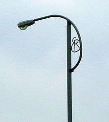
At 3.3 km (2.1 mi), Highway 420 is the shortest 400-series highway, travelling through Niagara Falls from Montrose Road to Stanley Avenue,[1] on the outskirts of the city's tourist district.[2] East of Stanley Avenue (Regional Road 102) the highway becomes Niagara Regional Road 420 and is known as Falls Avenue and Newman Hill on approach to the Rainbow Bridge. This portion was designated a part of Highway 420 until 2000, when it was transferred to the City of Niagara Falls and the Regional Municipality of Niagara, although the Ministry of Transportation of Ontario (MTO) still assists with the maintenance of it under a Connecting Link agreement.[3] East of Drummond Road,[4] Highway 420 features stylized light fixtures with the letters "ER", which stand for Elizabeth Regina and are a tribute to The Queen Mother.[5]
Highway 420 begins in the west at a signalized intersection with Montrose Road (Regional Road 98),[6] beyond which it continues as Watson Street through the residential neighbourhood of Greens Corners to Beaverdams Road (Regional Road 53).[2] East of Montrose Road, the highway is a four lane roadway divided by a raised paved median, and passes north of a forest as it approaches an interchange with the QEW. As well as a partial cloverleaf interchange that provides almost all directional movements, this four-level stack interchange features two flyovers that arc from south to east as well as a four lane mainline that curves from north to east, directing most westbound Highway 420 traffic onto the Toronto-bound QEW.[6]
East of the QEW, Highway 420 encounters an interchange with Dorchester Road as both cross the Queenston-Chippawa Power Canal.[7] This interchange was originally a traffic circle that was removed in the early 1970s.[8] The numerous lanes from the stack interchange to the west begin to converge between residential subdivisions east of Dorchester Road, gradually narrowing to four through lanes at the Drummond Road interchange.[7] After passing beneath Portage Road, the route widens on approach to an at-grade intersection with Stanley Avenue. This intersection is the eastern end of both the freeway segment of the route and the signed King's Highway 420; east of Stanley Avenue the route is signed as Niagara Regional Road 420 and known as Falls Avenue.[9][10]
Now separated by a landscaped median, the route progresses eastward, intersecting MacDonald Avenue and providing access to several residential and retail properties that adjoin the road. The route travels within a concrete trench and abruptly curves to the southeast as it passes beneath Victoria Avenue, with which there is a simple interchange.[7] East of this point, the road was named Newman Hill until March 2012. Palmer Avenue and Ontario Avenue pass over the route as it descends a hill towards the Niagara Gorge. At the bottom, the route curves to the southwest, where it provides access to the Rainbow Bridge border crossing into the United States as well as the tourist district of the city.[9]
Due to its association with the number 420 in cannabis culture, Highway 420 is also the location for the annual Cannabis Conference and Protest, usually taking place sometime around April 20. The event includes a march beginning near Niagara Falls and travelling to Highway 420.[11][12]
History
Rainbow Bridge Approach


The history of Highway 420 predates its designation by nearly 75 years, tied in with the crossing of the Niagara Gorge between the twin cities of Niagara Falls. The first level crossing between the two cities was the Honeymoon Bridge, constructed in 1898. The 14 m (46 ft) wide structure spanned 255 m (837 ft) between the Canadian and American sides, 58 m (190 ft) above the Niagara River. Its narrow design proved to be a fatal flaw, and on January 27, 1938, under the weight of a massive ice jam in the river, the structure collapsed.[13] A day later, the owners of the previous bridge — the International Railway Company (IRC) — as well as the Minister of Highways Thomas Baker McQuesten announced intentions to construct a new span; a long political battle ensued for several years over the merits of private or public ownership of border crossings. In the end, the Niagara Falls Bridge Commission (NFBC) paid the IRC $615,000 to purchase the right-of-way of the old bridge as well as the rights to construct the new one.[14] The future Rainbow Bridge was royally dedicated by King George VI and Queen Elizabeth on June 7, 1939, just hours after the couple dedicated the QEW.[15]
On May 16, 1940, Samuel Johnson, the vice-chair of the NFBC, and McQuesten, who along with his parliamentary role was chair of the commission, ceremonially turned the first sod for the new bridge using a two-handled shovel.[14] Construction had begun two weeks earlier on May 4.[15] The new bridge was assembled over the following 18 months; the design was prepared by New York engineering firm Waddell & Hardesty and supervised by the Edward Lupfer Corporation, the latter the designers of the Peace Bridge.[16] The new structure was located 167 m (548 ft) downstream from the Honeymoon Bridge, as the gorge is slightly wider at that point, resulting in a 288 m (945 ft) span.[17]
Meanwhile, McQuesten was overseeing construction of the QEW between Toronto and Fort Erie. The new dual highway, inspired by German Autobahns, was the first of its kind in Canada.[note 1] The outbreak of World War II in September 1939 temporarily halted McQuesten's ambitions, as funding was quickly shifted to the war effort. As a result, construction on the new superhighway was put on hold south of Niagara Falls. McQuesten officially opened the QEW on August 23, 1940; the pavement ended south of Lundy's Lane.[18] Despite the war, work began on a link between the highway and the Rainbow Bridge through the centre of Niagara Falls. This link would not be completed in time for the opening of the new bridge.[19]
On November 1, 1941, the Rainbow Bridge was officially opened during a simple ceremony. The oldest living couple known to have wed in Niagara Falls, a pair from Pennsylvania, were the first to cross, followed by a newlywed couple from Georgia. This symbolically tied the history of the two bridges together, and was followed by McQuesten and Johnson walking towards the centre of the structure from the Canadian and American sides, respectively, and shaking hands at the centre. Several pyrotechnic explosions at both ends capped the ceremony, and the bridge was opened to traffic.[14]

Work continued on the four lane bridge approach throughout 1941, and by mid-1942 it was possible to drive directly from the bridge onto the QEW. The new link featured a traffic circle at Dorchester Road as well as at the QEW.[16] Four gravel lanes opened between Niagara Falls and Fort Erie during the summer of 1941, becoming the main route of the QEW.[20] As a result, what would become Highway 420 was referred to by several names, including the Queen Elizabeth Way Extension (and known by locals for decades as the "Queen E Extension")[21] and the Rainbow Bridge Approach.[22]
Upgrade to freeway
During the mid-1960s, the Department of Highways examined the possibility of extending the freeway portion of the route east towards the Rainbow Bridge. They began to purchase properties lining Roberts Street in 1966.[23] In 1971, construction began on a three-level stack interchange between the QEW and the Rainbow Bridge Approach. This removed the two traffic circles along the approach.[8] The interchange between the QEW and Lundy's Lane (Highway 20) was also removed; instead, the new stack interchange included access to Montrose Road.[24] By April 1972, the Rainbow Bridge Approach was designated as Highway 420.[25][26]
In 1998, the Niagara Falls Transportation Study was released, recommending that Roberts Street be rebuilt as a gateway to the city as opposed to a freeway. Highway 420 east of Stanley Avenue was transferred to Niagara Region.[23] While the section near the QEW junction has high-mast lighting, like other provincial freeways, the rest of the route (including Regional Road 420) had the "ER" lightposts, to commemorate the route's historical status as the original routing of the QEW and its historical tie to the Queen Mother.[27]
On September 23, 2010, Highway 420 was designated as the Niagara Veterans Memorial Highway.[28] On January 31, 2012, Niagara Regional Council approved the renaming of Roberts Street and Newman Hill as an extension of Falls Avenue, beginning March 1. Prior to this, Falls Avenue curved into Newman Hill at the Rainbow Bridge.[10]
Exit list
The following table lists the major junctions along Highway 420, as noted by the Ministry of Transportation of Ontario.[1] The entire route is located in the Regional Municipality of Niagara.[9] All exits are unnumbered.
| Location | km[1] | mi | Destinations | Notes | |
|---|---|---|---|---|---|
| Niagara Falls | 0.0 | 0.0 | At-grade; western terminus of Highway 420; continues as Watson Street | ||
| 0.4 | 0.25 | Westbound exit and eastbound entrance | |||
| 1.1 | 0.68 | Dorchester Road | |||
| 2.2 | 1.4 | Drummond Road | |||
| 3.3 | 2.1 | At-grade; eastern terminus of Highway 420; continues as Roberts Street / Regional Road 420, maintained as a Connecting Link[3] | |||
| 4.8 | 3.0 | Rainbow Bridge to United States | Former eastern terminus[1] | ||
1.000 mi = 1.609 km; 1.000 km = 0.621 mi
| |||||

References
Notes
- ↑ Cootes Drive in Hamilton is also claimed as the first dual highway in Canada, although the QEW was the first divided highway designed for long-distance travel.
Sources
- 1 2 3 4 5 Ministry of Transportation of Ontario (2012). "Annual Average Daily Traffic (AADT) counts". Retrieved August 3, 2016.
- 1 2 Rand McNally & Co (1996). Golden Horseshoe (Map). 1:25,000. Allmaps Canada. pp. 348–349. ISBN 978-0-88640-767-4.
- 1 2 Contract Management and Operations Branch (2011). Highway Connecting Link List (Report). Ministry of Transportation of Ontario.
- ↑ Google (July 2015). "View from Drummond Road showing standard luminaires to the west and "ER" luminaires to the east". Google Street View. Google. Retrieved July 13, 2016.
- ↑ The History of Toronto's Unfinished Expressway System (Report). Energy Probe. April 5, 2009. p. 4. Retrieved January 23, 2012.
- 1 2 Google (January 30, 2012). "QEW / Highway 420 interchange" (Map). Google Maps. Google. Retrieved January 30, 2012.
- 1 2 3 Google (January 30, 2012). "Highway 420 length and route" (Map). Google Maps. Google. Retrieved January 30, 2012.
- 1 2 Stamp (1987), p. 65.
- 1 2 3 MapArt (2010). Ontario Back Road Atlas (Map). 1:250,000. Peter Heiler. p. 19. §§ S34–35. ISBN 978-1-55198-226-7.
- 1 2 Forsyth, Paul (February 2, 2012). "Roberts Street to Become Falls Avenue". Niagara This Week. Retrieved March 17, 2012.
- ↑ "Home". Highway 420 Anti-Prohibition Rally. n.d. Archived from the original on February 18, 2012. Retrieved July 13, 2016.
- ↑ Law, John (April 20, 2014). "420 Rally Urges Need For Legal Weed". Niagara Falls Review. Retrieved August 7, 2016.
- ↑ Stamp (1992), p. 123.
- 1 2 3 Stamp (1992), pp. 124–125.
- 1 2 Berketa, Rick (February 20, 2012). "Bridges Over Niagara River". Niagara Falls Thunder Alley. Retrieved July 22, 2016.
- 1 2 Stamp (1992), pp. 126–127.
- ↑ Stamp (1992), p. 128.
- ↑ "Queen Elizabeth Roadway to Open". Evening Courier. Prescott, Arizona. August 23, 1940. Retrieved January 11, 2012.
- ↑ Stamp (1992), p. 129.
- ↑ Stamp (1987), p. 49.
- ↑ A.A.D.T. Traffic Volumes 1955–1969 And Traffic Collision Data 1967–1969. Ontario Department of Highways. 1970. p. 4.
- ↑ Stamp (1987), pp. 126–127.
- 1 2 Conradi, Peter (August 17, 2008). "Roberts Street Gateway to be Renamed Falls Avenue". Bullet News Niagara. Retrieved March 12, 2012.
- ↑ Cartography Section (1977). Ontario Road Map (Map). 1:800,000. Ministry of Transportation and Communications. South-Central Ontario inset.
- ↑ "Queen Elizabeth Way - Hamilton to Fort Erie". Highway Construction Program 1972-73 (Report). Ministry of Transportation and Communications. April 1972. p. xv.
- ↑ Walter, Karena (February 21, 2014). "Search Engine: Highway Mysteries Solved". Niagara Falls Review. Retrieved April 19, 2014.
- ↑ Stamp (1987), pp. 31–34.
- ↑ Ricciuto, Tony (September 23, 2010). "Niagara Veterans Memorial Highway now official". Niagara Falls Review.
Bibliography
- Stamp, Robert M. (1987). QEW – Canada's First Superhighway. The Boston Mills Press. ISBN 0-919783-84-8. OCLC 19222948.
- Stamp, Robert M. (1992). Bridging the Border: Structures of Canadian–American Relations. Toronto: Dundurn Press. ISBN 1-55002-074-9. OCLC 26930343.
External links
| Wikimedia Commons has media related to Ontario Highway 420. |