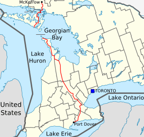
Ontario Highway 6
| ||||
|---|---|---|---|---|
| Garafraxa Road | ||||
 | ||||
| Route information | ||||
| Length: | 472.4 km[1] (293.5 mi) | |||
| Existed: | June 1920[2] – present | |||
| Major junctions | ||||
| South end: | St. Patrick Street - Port Dover | |||
|
| ||||
| North end: |
| |||
| Location | ||||
| Major cities: | Hamilton, Guelph, Owen Sound | |||
| Towns: | Port Dover, Jarvis, Hagersville, Caledonia, Ancaster, Aberfoyle, Fergus, Arthur, Mount Forest, Durham, Chatsworth, Shallow Lake, Wiarton, Tobermory, Little Current, Espanola | |||
| Highway system | ||||
| ||||

King's Highway 6, commonly referred to as Highway 6, is a provincially maintained highway in the Canadian province of Ontario. It crosses a distance of 480 km (300 mi) between Port Dover, on the northern shore of Lake Erie, and Espanola, on the northern shore of Lake Huron, before ending at the Trans-Canada Highway (Highway 17) in McKerrow.[3]
Highway 6 was one of several routes established when Ontario first introduced a highway network on February 26, 1920, following several pioneer wagon trails. The original designation, not numbered until 1925, connected Port Dover with Owen Sound via Hamilton and Guelph. When the Department of Highways (DHO) took over the Department of Northern Development (DND) in 1937, Highway 6 was extended north through the Bruce Peninsula to Tobermory. In 1980, the entire length of Highway 68 on Manitoulin Island and north to Highway 17 became a northern extension of Highway 6. Small modifications were made to the route of Highway 6 in 1997, but it was largely untouched by provincial downloading.
Highway 6 is one of two highways in Ontario (the other being Highway 33) broken into two segments by a ferry. The MS Chi-Cheemaun Ferry serves automobile traffic, connecting Tobermory with South Baymouth between May and October.
Route description
Port Dover to Hamilton
Highway 6 begins at Saint Patrick Street in the community of Port Dover, and stretch northward as a two-lane, undivided highway. The road travels into Haldimand County, through communities such as Jarvis and Hagersville, and the traffic flow increases. By the time the highway reaches Caledonia, the road bypasses the former Highway 6 section (Argyle Street), which passes the town centre of Caledonia. With the newly built bypass, Highway 6 is routed outside the urban centre of Caledonia. The Caledonia Bypass was opened in 1983, and is a two-lane undivided freeway. The bypass terminates at Green's Road on the north side of Caledonia and Highway 6 proceeds eastbound on Green's Road for approximately 500 metres to Argyle St North. Highway 6 then turns north on a four lane undivided alignment for 5 km. Much of the old alignment north to near Rymal Road remains provincially maintained as unsigned Highway 7273. In Hamilton, Highway 6 now uses a new alignment from Highway 403 to south of the Hamilton Airport, connecting with the southerly leg to Caledonia and Port Dover. The new alignment opened as an undivided two-lane freeway in November 2004; it is expected to expand to a full 4-lane divided highway, and to extend to past Caledonia, by some time in the 2010s. As the road meets Highway 403, Highway 6 merges with Highway 403, and there is a concurrency for 17 kilometres. The concurrency ends at the Highway 6 junction, at the Hamilton/Burlington boundary, near the Royal Botanical Gardens.[4][5]
Hamilton to Guelph
Though most of the route is five lanes — two travel lanes in each direction, plus one centre lane for left turns — the section in Wellington County from Puslinch to Morriston has remained two lanes because of its route through several small towns and a lack of available property for widening; this area therefore suffers from significant congestion. A new alignment, connecting to the Hanlon Expressway at Highway 401, is being considered to bypass this troubled section. The section where Highway 6 is concurrent with Highway 401 has the highest AADT (Annual Average Daily Traffic), at 85,000 automobiles per day in 2002. High travel speeds in the five-lane section, and typical flow varies between 100 and 120 km/h (62 and 75 mph).[4][5]
The section of Highway 6 between Highway 403 in Hamilton and Clappison's Corners (the intersection at Hwy 5 West) was converted in 2009 to a controlled access freeway with an interchange at York Road. The interchange opened on May 23, 2009, and simultaneously, the intersection where Northcliffe/Plains Road met Highway 6 was closed permanently. (A new service road was built on either side to connect Plains Road and various other residential streets to the York Road interchange.) This section of Highway 6 has two southbound lanes and three northbound, the extra lane being for trucks climbing the steep escarpment, as well as high mast lighting and a full concrete median barrier.[4][5]
In Guelph, the road travels along the full length of the Hanlon Expressway - a 4-lane, controlled access and divided highway with signalized level crossings. The Ministry of Transportation is presently investigating the possibility of changing these intersections into grade-separated interchanges. For 4 km Highway 6 is concurrent with Highway 7, from the Wellington Street interchange north to where the Hanlon Expressway ends at Woodlawn Road. At Woodlawn, Highway 7 veers west, and Highway 6 continues east. Following Woodlawn, Highway 6 then veers north onto Woolwich Street, leaving the city of Guelph.[4][5]
Guelph to Owen Sound
As Highway 6 leaves Guelph and heads northwards through Wellington County, it narrows to two lanes and passes through farmland. The route meanders northward for 17 kilometres (11 mi) before entering Fergus, where it meets County Road 18 and County Road 19. North of Fergus, Highway 6 winds northwest for another 17 kilometres into Arthur meeting County Road 109 (former Highway 9) just south of the town. After exiting Arthur, the route continues northwest for 22 kilometres (14 mi) before entering Mount Forest and meeting an intersection with Highway 89.[4][5]
The route enters Grey County as it curves and meanders northward into farmland. It progresses north for another 22 kilometres to Durham, where it intersects Highway 4. It continues for another 31 kilometres (19 mi) to Chatsworth, where it meets Highway 10 and travels northward concurrent with for 13 kilometres (8.1 mi) into Owen Sound. There it encounters an intersection, where Highway 10 ends; from here, Highway 26 continues north then east to Collingwood and Barrie, while Ontario Highway 21 travels east and then south towards Sarnia. Highway 6 turns west onto Highway 21, forming the only wrong-way concurrency in Ontario. The two routes pass through downtown Owen Sound and onwards into Springmount, where they disembark from one-another; Highway 21 continues west, while Highway 6 turns north into the Bruce Peninsula.[4][5]

Owen Sound to Tobermory
At Springmount, Highway 6 ends its concurrency with Highway 21, and continues northwards into the Bruce Peninsula. The road remains as a two-lane highway for its full length up to Tobermory. Highway 6 spans 110 km across the peninsula. It passes through communities such as Shallow Lake, Hepworth, Wiarton, and Ferndale. It is named Berford Street in Wiarton, and 10th Street in Owen Sound. Along the road, Bruce Peninsula National Park can be found. At Tobermory, the highway travels along Carlton Road and Front Street, where motorists must queue for the MS Chi-Cheemaun Ferry to continue onwards to Manitoulin Island. The journey by ferry traverses waters of both Georgian Bay and Lake Huron from Tobermory to South Baymouth to Manitoulin Island takes approximately 1 hour and 45 minutes.[6]
The ferry service is not available from November to mid May, thus the road is broken from late fall to later spring.
South Baymouth to McKerrow

MS Chi-Cheemaun docks at South Baymouth, and Highway 6 continues as a two-lane highway. Highway 6 is both the main means of connection between Manitoulin Island and the rest of Ontario and the major highway on Manitoulin Island. Secondary Highways 540 and 542 on Manitoulin Island link back to Highway 6. The section from South Baymouth to the Highway 542 junction has the least traffic on a given day, with an average of 610 vehicles passing as measured in 2010.
Highway 6 continues north, passing through communities such as Manitowaning, Sheguiandah, and Little Current. At Little Current, Highway 6 crosses the North Channel by the Little Current Swing Bridge, which swings open for 15 minutes of each daylight hour in the summer to allow boats to pass through the channel.[7] This crossing is the only permanent 2-way one-lane bottleneck of the Ontario King's Highways.
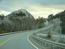
After crossing the North Channel, Highway 6 climbs through the La Cloche Mountains near Whitefish Falls (see image). Eventually, it arrives in Baldwin, north of Espanola, ending at Trans-Canada Highway 17 in the community of McKerrow, 117 km from South Baymouth.
History
Wagon trails
Prior to the establishment of Ontario's provincial highway network in 1920, the route that would become Highway 6 was composed of several early wagon trails created during the early settlement of what was then known as Upper Canada. These trails carved through an otherwise barren wilderness, connecting distant townsites: the Hamilton–Dover Plank Road between Port Dover and Hamilton, the Brock Road between Hamilton and Guelph, and the Garafraxa Road between Guelph and Sydenham (renamed to Owen Sound in 1851) — were opened in the 1830s and 1840s. Further north, the Southwest Diagonal and the Centre Road were built through the Bruce Peninsula in the 1840s and 1920s, respectively.[8][9]
In 1837, Charles Rankin was hired by the Canada Company to survey a line between Guelph and a new town site on the southern shore of Georgian Bay known as Sydenham. The Canada Company was formed by several British investors to purchase, open, and settle the Huron Tract, a vast wilderness stretching from Guelph north to Georgian Bay and west to Lake Huron. Rankin's line crossed too many natural obstacles, a result of the tendency to build roads that were straight rather than following the natural topography. Consequently, a new line was surveyed in 1840 by the company's own surveyor, John McDonald, and construction along this new route began. Around the same time, the Van Norman Company constructed a plank road between Port Dover and Hamilton known as both the Hamilton Plank Road and the Dover Road.[10][11] By 1848, the 119 km (74 mi) Garafraxa Road between Guelph and Sydenham was completed.[12][13]
The remaining section between Hamilton and Guelph, known as the Brock Road, was constructed between 1848 and 1850 over the Guelph and Dundas wagon road.[14] The wagon road, merely a trail through the forest, was cleared by the Canada Company in the 1820s to connect the fledgling town of Guelph with the established harbour at Hamilton, thus encouraging settlers to venture inland.[15]
Further north, the Southwest Diagonal was surveyed in 1842 by Charles Rankin to provide a short route from the Sydenham townsite to the Hepworth townsite. This route passed through a large swamp and as a result remained an unimproved one lane trail into the 1920s. The Centre Road, the spine of the Bruce Peninsula, was built by the Department of Northern Development in the early 1920s, providing access to communities north of Wiarton. The route followed a telegraph line between Lion's Head and Tobermory and opened up a large area previously accessible only by water.
The latter two would not be incorporated into the original route of Highway 6.
Provincial highway
When Ontario's Department of Public Highways first established a network of provincial highways on February 26, 1920 to be eligible for federal funding, it included the Hamilton and Dover Plank Road, the Brock Road and the Garafraxa Road.[16] These roads were assumed from the various counties that held jurisdiction over them – Norfolk, Haldimand, Wentworth, Wellington and Grey – throughout June, July and August 1920.[2]
The first major work undertaken on the then-unnumbered Highway 6 was improving the crossing of the Niagara Escarpment north of Hamilton. Work began in 1919 to blast rock and create a new ascent, which came to be known as the Clappison Cut, after the community located just north of it. This route, which was completed in 1923, bypassed the old Snake Road into Waterdown.[17] Below the escarpment, the highway followed what is now the Old Guelph Road, meandering into Hamilton.[18]
South of Hamilton, the road to Jarvis was numbered as Highway 5 when route numbers were assigned in the middle of 1925. Highway 5 and Highway 6 travelled concurrently from downtown Hamilton to Clappison's Corners.[19] However, on May 25, 1927, several route numbers were revised, including Highways 5 and 6. Highway 5 was redirected west from Clappison's Corners to Peter's Corners to meet Highway 8. Highway 6, in turn, assumed the route of Highway 5 south to Jarvis. Exactly two weeks prior, on May 11, the Department of Public Highways had assumed the road between Jarvis and Port Dover; this also became a section of Highway 6, establishing its southern terminus for the next seven decades.[20]
North of the escarpment to Highway 401, Highway 6 follows the same route that it did in 1920, the Brock Road. North of Highway 401, which didn't exist before the 1950s, the route continued through Guelph along what is now Gordon Street, Norfolk Street and Woolwich Street. This section has since been replaced by the Hanlon Expressway, built throughout the 1970s.
North of Guelph to Owen Sound, the route also follows the same route as it did in 1920, with some small deviations. The section from Fergus north towards Arthur followed the route was of the old Fergus and Arthur Road Company. A "cheap attempt" at paving had been made in the 1920s. The section was straightened, widened and paved with asphalt-based "penetration pavement" in 1930.[21]
On April 1, 1937, the Department of Northern Development was absorbed into the Department of Highways, which subsequently took over many development roads as provincial highways. Most of the northern sections of Highway 6 were included amongst these. Highway 68 was designated from Little Current north to Espanola on August 11, 1937. Two weeks later, on August 25, Highway 6 was designated in Bruce County, from Wiarton north to Tobermory. The section within Grey County was designated several months later on November 3.[22] The lone remaining section of what would eventually become today's Highway 6, across Manitoulin Island, was not designated until December 7, 1955.[23] The entirety of Highway 68 would eventually be redesignated as part of Highway 6 in the early to mid- 1980.[24]

Expressways and bypasses
- Longwoods Road extension
Under the leadership of Thomas B. McQuesten, who would soon introduce the freeway to Ontario, a new grand entrance to Hamilton was planned. It would cross the Desjardins Canal and terminate at a traffic circle, with Highway 2 continuing east and Highway 6 north. This new road, known as the Longwoods Road Extension, was built partially as a depression-relief project in the early 1930s. Upon completion in 1932, Highway 2 and Highway 6 were routed off the Old Guelph Road onto the new route into Hamilton. This configuration remained until the construction of Highway 403 during the early 1960s, which was built over the Longwoods Road Extension.
- Mount Hope Bypass
Due to the narrow spacing of buildings in the village of Mount Hope, a bypass of the village was built in the mid- to late 1950s.[25] The original route is now known as Homestead Drive.[26] The bypass opened on April 26, 1957, at which point the old routing was decommissioned.[25] It was subsequently bypassed, when the new Highway 6 opened to the southwest of John C. Munro Hamilton International Airport, on November 26, 2004.[27]
- Hanlon Expressway

With the rapid suburban expansion of Guelph in the 1950s and 1960s, a revised transportation plan was conceived to handle the increasing traffic load. The Guelph Area Transportation Study was completed in 1967, and recommended a new controlled-access highway to allow through-traffic on Highway 6 to bypass the city. Route planning, engineering and design began on October 2, 1967 and was subsequently completed in 1969.[28] Construction began between Waterloo Avenue and Stone Road in 1970; [29] this section opened on June 28, 1972.[30] The next section, from Stone Road to Clair Road, opened in October 1973.[29] Work on the northern section from Waterloo Avenue to Woodlawn Road began in August 1974.[31] It and the final section south to Highway 401 were opened on November 7, 1975.[32]
Initially, the 15.4-kilometre-long (9.6 mi) road featured no interchanges. However, the MTO has long-intended to upgrade the route to a freeway.[29][33] Construction of the Wellington Avenue interchange began in October 1998;[34] it opened in July 2001.[33] On April 30, 2012, construction began on the Laird Road interchange.[35] It partially opened on the week of November 11, 2013,[36] and was fully opened on November 29, 2013, in a public ceremony attended by local officials as well as Guelph MPP Liz Sandals.[35][37]
- Caledonia Bypass
In 1976, a corridor study was completed on Highway 6 between Port Dover and Hamilton, indicating a need for a bypass of Caledonia due to the aging multi-span bridge over the Grand River, to improve capacity to the developing areas of Nanticoke near Lake Erie,[38] and to reduce the high-volume of truck traffic passing through the town.[39] Construction began in late 1979 on structures to cross the Grand River and to carry rail lines and three crossroads over the bypass.[40] The bypass was completed in the fall of 1983.[39] The old route through Caledonia is now known as Argyle Street.[5]
Downloading and changes since

On April 1, 1997, Highway 6 was decommissioned south of Hepworth to Highway 21. The entire length of Highway 70 was subsequently renumbered Highway 6 to rectify the discontinuity. On the same day, the section between the southern terminus at former Highway 24 to the west side of the Lynn River.[41] These reduced the length of Highway 6 from 488.5 kilometres (303.5 mi) to 472.4 kilometres (293.5 mi).[1][42]
A new 9.7-kilometre-long (6.0 mi) segment of Highway 6 was opened to the southwest of John C. Munro Hamilton International Airport in 2004.[27] This building of this route had been planned since the construction of the Caledonia Bypass in 1983. However, concrete plans were not announced until January 1993. However, it had already drawn criticism due to an old-growth forest located in the path of the route. The planned highway would cost a projected $100 million.[43] However, these plans never came to fruition, and by 1997 a new, shorter route was in the planning stages.[44] Construction of the $33 million route was announced on May 26, 2000 by Transportation Minister David Turnbull,[45] and began in July 2003.[46]
The new route was opened on November 26, 2004.[47] The section through Hamilton at the time followed Upper James Street through the Claremont Access onto the one-way pairings of Wellington Street and Victoria Avenue then Main Street and King Street. It turned north on Dundurn Street and crossed Cootes Paradise via York Boulevard before turning onto Plains Road and meeting the current route at the now-closed intersection.[48] The responsibility for this routing was subsequently transferred to the City of Hamilton.[27]
In early 2002, it was announced that the section of Highway 6 north of Hamilton, from Highway 403 north to beyond Highway 5, would be widened to a five lane freeway.[49] This work began in 2006, widening and dividing the highway up the Clappison Cut. The York Road interchange opened on May 23, 2009, following completion of this work. The Plains Road / Northcliffe Avenue intersection was closed the night before and a new section of Plains Road opened on the same day as the interchange.[50] Highway 6 now features an additional northbound truck-climbing lane as a result of this $34 million project.[51]
Major intersections
The following table lists the major junctions along Highway 6, as noted by the Ministry of Transportation of Ontario.[1]
| Division | Location | km[1] | mi | Exit | Destinations | Notes |
|---|---|---|---|---|---|---|
| Norfolk | Halfway House Corners | −7.7 | −4.8 | Norfolk County Highway 24 – Simcoe | ||
| Port Dover | 0.0 | 0.0 | ||||
| Haldimand | Jarvis | 13.4 | 8.3 | Jarvis Connecting Link | ||
| 15.0 | 9.3 | County Road 69 (Nanticoke Creek Parkway) | ||||
| 16.3 | 10.1 | County Road 55 (Nanticoke Road) | ||||
| 21.1 | 13.1 | County Road 18 (Sandusk Road) | ||||
| Hagersville | 23.5 | 14.6 | County Road 20 (King Street) | Hagersville Connecting Link | ||
| Caledonia | 35.4 | 22.0 | Argyle Street South | Beginning of Caledonia Bypass; controlled-access Super 2 | ||
| 38.7– 38.9 | 24.0– 24.2 | |||||
| 41.9 | 26.0 | Argyle Street North | End of Caledonia Bypass | |||
| Hamilton | 48.0 | 29.8 | Highway 7273 (Upper James Street) | Former Highway 6 prior to November 2004 | ||
| 50.0 | 31.1 | To John C. Munro Hamilton International Airport | ||||
| 54.8 | 34.1 | Book Road | ||||
| Freeway begins | ||||||
| 57.5 | 35.7 | 61 | Beginning of Highway 403 concurrency | |||
| 60.4 | 37.5 | 64 | Lincoln M. Alexander Parkway Rousseaux Street | |||
| 65.2 | 40.5 | 69 | Aberdeen Avenue | |||
| 66.6 | 41.4 | 70 | Main Street | Formerly Highway 8; entrance ramps from nearby King St. | ||
| 68.9 | 42.8 | 73 | York Boulevard | Westbound exit and eastbound exit; formerly Highway 6 south | ||
| Hamilton–Halton boundary | Hamilton–Burlington boundary | 70.3 | 43.7 | 74 | Eastern end of Highway 403 concurrency | |
| 71.7 | 44.6 | York Road | ||||
| Freeway ends | ||||||
| Hamilton | 73.3 | 45.5 | Clappison's Corners | |||
| 77.2 | 48.0 | Millgrove Sideroad | ||||
| 83.3 | 51.8 | Carlisle Road | ||||
| 86.4 | 53.7 | Regional Road 97 west – Cambridge | Freelton; former Highway 97 | |||
| Wellington | Morriston | 90.1 | 56.0 | County Road 36 | ||
| Puslinch | 91.0 | 56.5 | 299 | Beginning of Highway 401 concurrency | ||
| 95.4 | 59.3 | 295 | End of Highway 401 concurrency | |||
| 96.5 | 60.0 | Concession Road 4 Maltby Road West | ||||
| Guelph | 100.5 | 62.4 | Clair Road West Phelan Drive | Closed with opening of Laird Road Interchange[35] | ||
| 101.1 | 62.8 | Laird Road | Grade-separated as of November 29, 2013[35] | |||
| 103.6 | 64.4 | Downey Road (west) Kortright Road West (east) | ||||
| 104.6 | 65.0 | Stone Road West | ||||
| 105.5 | 65.6 | College Avenue West | ||||
| 107.1 | 66.5 | Southern end of Highway 7 concurrency. Grade-separated as of July 2001.[33] Formerly Highway 24. | ||||
| 108.1 | 67.2 | Paisley Road | ||||
| 108.9 | 67.7 | Willow Road | ||||
| 109.8 | 68.2 | Speedvale Avenue West | ||||
| 110.8 | 68.8 | Highway 6 continues eastward along Woodlawn Road West; Highway 7 continues westward. | ||||
| 113.1 | 70.3 | Woolwich Street | Former route of Highway 6; Guelph Connecting Link | |||
| Guelph/Eramosa | 115.4 | 71.7 | County Road 7 (Elora Road) – Elora | |||
| 117.3 | 72.9 | County Road 38 (Victoria Road North) | ||||
| Fergus | 129.8 | 80.7 | County Road 18 (St. Andrew Street) – Elora | Fergus Connecting Link | ||
| Arthur | 148.3 | 92.1 | County Road 109 | Former Highway 9 | ||
| 148.5 | 92.3 | Bridge over the Conestoga River | Arthur Connecting Link | |||
| Mount Forest | 172.5 | 107.2 | Mount Forest Connecting Link | |||
| Grey | Durham | 195.3 | 121.4 | Douglas Street | Durham Connecting Link | |
| 196.5 | 122.1 | |||||
| 197.2 | 122.5 | County Road 27 west (Durham Road) | Old alignment of Highway 4; Durham Connecting Link | |||
| Williamsford | 219.4 | 136.3 | County Road 24 east (Chatsworth Road 24) | |||
| Chatsworth | 227.0 | 141.1 | County Road 40 west | Owen Sound Bypass; Beginning of Chatsworth Connecting Link | ||
| 228.6 | 142.0 | Southern end of Highway 10 concurrency; end of Chatsworth Connecting Link | ||||
| Owen Sound | 240.2 | 149.3 | Superior Street / 4th Street East | Beginning of Owen Sound Connecting Link | ||
| 241.5 | 150.1 | End of Highway 10. Highway 6 north turns west onto 10th Street and becomes concurrent with Highway 21 south through Owen Sound. | ||||
| 242.8 | 150.9 | |||||
| 244.1 | 151.7 | Alpha Street north / 9th Avenue West south | End of Owen Sound Connecting Link | |||
| Springmount | 246.8 | 153.4 | County Road 18 | Beginning of former Highway 70 | ||
| Cruickshank | 252.6 | 157.0 | Ledgerock Road | |||
| Shallow Lake | 257.0 | 159.7 | County Road 170 (Cruickshank Street) – Copperkettle | |||
| Bruce | Hepworth | 261.4 | 162.4 | County Road 10 south (Bruce Street) County Road 8 west (Queen Street) – Sauble Beach | End of former Highway 70 | |
| Wiarton | 273.2 | 169.8 | County Road 1 (Frank Street) – Keppel Croft | Wiarton Connecting Link | ||
| 274.5 | 170.6 | County Road 13 (Jenny Street) – Oliphant | ||||
| South Bruce Peninsula | 276.7 | 171.9 | County Road 9 north – Colpoy's Bay | |||
| Northern Bruce Peninsula | 303.6 | 188.6 | County Road 9 south (Ferndale Road) – Lion's Head | Ferndale | ||
| Tobermory | 356.3 | 221.4 | Big Tub Road / Front Street | Tobermory Ferry Docks | ||
| Georgian Bay | ||||||
| Manitoulin | South Baymouth | 356.3 | 221.4 | Water Street / Given Road | South Baymouth Ferry Docks. The entire route from this location northerly to McKerrow was designated as Highway 68 prior to 1980. | |
| Tehkummah | 369.2 | 229.4 | ||||
| Manitowaning | 386.2 | 240.0 | Merideth Street | |||
| Sheguiandah | 410.6 | 255.1 | Green Bay Road / Sheguiandah Bay Road | |||
| Little Current | 421.2 | 261.7 | ||||
| Sudbury | Espanola | 465.8 | 289.4 | Foster Drive | Espanola Connecting Link | |
| 469.7 | 291.9 | Tudhope Street | ||||
| McKerrow | 472.4 | 293.5 | ||||
1.000 mi = 1.609 km; 1.000 km = 0.621 mi
| ||||||
References
- 1 2 3 4 Ministry of Transportation of Ontario (2010). "Annual Average Daily Traffic (AADT) counts". Retrieved January 23, 2014.
- 1 2 "Report on Provincial Highways". Annual Report (Report). Department of Highways. January 30, 1921. pp. 40–45.
- ↑ Road Atlas – Canada, United States, and Mexico (Map) (2008 ed.). Peter Heiler Ltd. p. 17, 19. § B6–G7, G8–K8, L9, M10–R11.
- 1 2 3 4 5 6 Ontario Back Road Atlas (Map). Cartography by MapArt. Peter Heiler Ltd. 2010. pp. 17, 22–23, 28–29, 39, 54–55. § S14–V28. ISBN 978-1-55198-226-7.
- 1 2 3 4 5 6 7 Google (January 23, 2014). "Highway 6 - length and route" (Map). Google Maps. Google. Retrieved January 23, 2014.
- ↑ "Fares of the Chi-Cheemaun Ferry". MS Chi-Cheemaun Ferry. Retrieved June 30, 2007.
- ↑ "Images of Highway 6 at Little Current". Ontario King's Highways. Retrieved 2007-07-03.
- ↑ Annual Report. Retrieved 9 December 2014 – via Google Books.
- ↑ "Full text of "The Bruce Beckons The Story Of Lake Huron S Great Peninsula"". Archive.org. Retrieved 9 December 2014.
- ↑ Ontario Historical Society (1919). Ontario History. Kraus Reprint. p. 95. Retrieved October 18, 2010.
- ↑ Report of the Commissioners ... laid before the Legislative assembly, 12th ... Retrieved 9 December 2014 – via Google Books.
- ↑ Discover Your Heritage. Retrieved 9 December 2014 – via Google Books.
- ↑ Letters from Bruce County. Retrieved 9 December 2014 – via Google Books.
- ↑ Encyclopedia of Ontario: Places in Ontario. pt. 1. A-E. pt. 2. F-M. pt. 3. N-Z. Retrieved 9 December 2014 – via Google Books.
- ↑ Hometown Horizons. Retrieved 9 December 2014 – via Google Books.
- ↑ Shragge, John; Bagnato, Sharon (1984). From Footpaths to Freeways. Ontario Ministry of Transportation and Communications, Historical Committee. pp. 71–75. ISBN 0-7743-9388-2.
- ↑ Tidridge, Nathan (2012). The Extraordinary History of Waterdown, West & East Flamborough. Stone Soup Publications. pp. 63–64, 67. ISBN 978-0-9734438-1-3.
- ↑ Ontario Road Map (Map). Cartography by D. Barclay. Ontario Department of Public Highways. 1927. § F5.
- ↑ "Provincial Highways Now Being Numbered". The Canadian Engineer. Monetary Times Print. 49 (8): 246. August 25, 1925.
Numbering of the various provincial highways in Ontario has been commenced by the Department of Public Highways. Resident engineers are now receiving metal numbers to be placed on poles along the provincial highways. These numbers will also be placed on poles throughout cities, towns and villages, and motorists should then have no trouble in finding their way in and out of urban municipalities. Road designations from "2" to "17" have already been allotted... Road No. 5 — Toronto to Jarvis, via Dundas Highway and Hamilton. Route No. 6 — Hamilton to Owen Sound.
- ↑ "Appendix 6 - Schedule of Assumptions and Reversions of Sections". Annual Report (Report). Department of Public Highways. March 31, 1928. p. 60.
- ↑ Thorning Stephen. "Highway departments undertook paving despite 1930 Depression". The Wellington Advertiser. Retrieved 14 September 2014.
- ↑ "Appendix 3 - Schedule of Assumptions and Reversions of Sections". Annual Report (Report). Department of Highways. March 31, 1938. p. 80.
- ↑ "Appendix 3 - Schedule of Assumptions of Sections". Annual Report (Report). Department of Highways. March 31, 1956. p. 204.
- ↑ Public and Safety Information Branch (December 13, 1979). "Highway 68 on Manitoulin Island to be Renumbered as Highway 6" (Press release). Ministry of Transportation and Communications.
- 1 2 Annual Report (Report). Department of Highways. March 31, 1958. p. 238.
- ↑ Google (January 22, 2014). "Aerial view of Mount Hope" (Map). Google Maps. Google. Retrieved January 22, 2014.
- 1 2 3 De Almeida, Jacquie (November 27, 2004). "The road to development; New $40m stretch of Highway 6 brings business, jobs, passengers to airport". Hamilton Spectator. p. A4.
- ↑ Functional Planning Study of the Hanlon Expressway (Report). Read Voorhees & Associates Limited. 1969. pp. 1–4.
- 1 2 3 The Guelph Transportation Study Committee, The New Hanlon Technical Advisory Committee (June 1974). "History of the Hanlon Expressway". Protecting The Option For Future Interchanges And Grade Separations In The Hanlon Corridor City Of Guelph Report 10 of the Guelph Transportation Plan (Report). Marshall Macklin Monghan Limited. pp. 6–7. Retrieved December 18, 2013.
- ↑ "Felix Hanlon". Guelph Public Library. Retrieved December 14, 2013.
- ↑ Fear, Jonathan (August 15, 1974). "$230 million to be spent on roads this year: Passing lanes may become common on Ontario highways". Toronto: The Globe and Mail. p. 4.
- ↑ "Photo Database – Guelph Mercury Fonds, records 131–133". Guelph Public Library. Retrieved December 15, 2013.
- 1 2 3 Kirsch, Vik (September 4, 2004). "Expressway still the plan for Hanlon". Guelph Mercury. p. A1.
|section=ignored (help) - ↑ Ministry of Transportation of Ontario (November 24, 1998). "Project To Complete Wellington Street Interchange Underway". Government of Ontario.
- 1 2 3 4 Cartwright, Peter; Philips, Rajan (November 29, 2013). "City and MTO Officially Open Hanlon Expressway/Laird Road Provincial Interchange". City of Guelph. Retrieved December 14, 2013.
- ↑ Rajan Philips (November 8, 2013). "New Interchange at the Hanlon Expressway and Laird Road to be opened". City of Guelph. Retrieved December 14, 2013.
- ↑ Cartwright, Peter (November 27, 2013). "Hanlon Expressway/Laird Road provincial interchange ceremonial opening". City of Guelph. Retrieved January 8, 2013.
- ↑ Route Projects Planning Office (1976). Highway 6, Nanticoke to Hamilton: joint use corridor study (Report). Ministry of Transportation and Communications.
- 1 2 Lee, Prokaska (January 29, 2001). "Caledonia bypass repairs still on; But province won't say when it'll fund intersection work". Hamilton Spectator. p. A11.
The bypass, which opened in the fall of 1983, was constructed to divert truck traffic away from the core of Caledonia...
- ↑ Construction Program: King's and Secondary Highways. Ministry of Transportation and Communications. 1980–1981. p. XII.
- ↑ Highway Transfers List (Report). Ministry of Transportation of Ontario. April 1, 1997. pp. 2, 4–5.
- ↑ Provincial Highways Distance Table. Ministry of Transportation of Ontario. 1989. pp. 15–8. ISSN 0825-5350.
- ↑ Nolan, Dan (January 5, 1993). "$100 highway project could run into a snag Centuries-old forest on route". Hamilton Spectator. p. B1.
- ↑ "Bridge over Highway 403 finally leads somewhere : Extension is still years from completion". Hamilton Spectator. November 27, 1997. p. A4.
- ↑ Pettapiece, Mike (May 27, 2000). "Ontario gives $33m for Hwy. 6 link; Two-lane connection to airport will be ready in 2004". Hamilton Spectator. p. A1.
- ↑ Nolan, Dan (November 24, 2004). "Highway to the Sky: Roadway lifts airport's future; Long- anticipated link between Highways 6 and 403 is expected to drive development at the airport and stimulate growth throughout the region.". Hamilton Spectator. p. A1.
- ↑ Ministry of Transportation (November 26, 2004). "Ontario Government Opens New Highway in Hamilton". Government of Ontario. Archived from the original on May 26, 2005. Retrieved January 24, 2014.
- ↑ Ontario Official Road Map (Map). Cartography by Geomatics Office. Ministry of Transportation. 2003. Burlington and Hamilton inset.
- ↑ Longbottom, Ross (February 5, 2002). "Clappison's Corners centrepiece of highway changes". Hamilton Spectator. p. A9.
- ↑ Nolan, Dan (May 22, 2009). "Hwy. 6-York Road interchange to open Saturday". Hamilton Spectator. p. unknown. Retrieved January 23, 2014.
- ↑ Nolan, Daniel (May 12, 2009). "After 10 years, Hwy. 6, York interchange ready to open". Hamilton Spectator. p. A5.
External links
| Wikimedia Commons has media related to Ontario Highway 6. |