Ontario Highway 409
| ||||
|---|---|---|---|---|
| Belfield Expressway | ||||
 | ||||
| Route information | ||||
|
Maintained by Ministry of Transportation of Ontario Greater Toronto Airports Authority | ||||
| Length: | 5.6 km[1][2] (3.5 mi) | |||
| Existed: | August 25, 1978[3] – present | |||
| Major junctions | ||||
| West end: |
| |||
|
| ||||
| East end: |
| |||
| Highway system | ||||
| ||||
King's Highway 409, commonly referred to as Highway 409 and historically as the Belfield Expressway, is a 400-series highway in the Canadian province of Ontario that extends from Highway 401 in Toronto to Pearson International Airport, west of Highway 427, in Mississauga. It is a short freeway used mainly as a spur route bypass for traffic approaching the airport or Highway 427 northbound from Highway 401 westbound, as both are not accessible at the complex interchange between Highways 401 and 427.
Planning for Highway 409 took place throughout the late 1960s amidst considerable controversy around its original path through the historic town of Malton. Eventually the route was changed to provide access to the airport instead of towards Brampton and completed through the mid-1970s, opening in 1978. The significance of the route has increased over the years alongside expansion of the airport. In 2000, the Greater Toronto Airports Authority (GTAA) purchased the section west of Highway 427 in order to modify the ramps leading into the airport.
The speed limit along Highway 409 is 100 kilometres per hour (62 mph) east of Highway 427 and 60 km/h (37 mph) west of it. It is patrolled by the Ontario Provincial Police east of the Toronto–Peel boundary and by the Peel Regional Police to the west of it. The original name of the freeway was derived from the road running parallel to and north of it, Belfield Road. Belfield is a local road managed by the City of Toronto and runs from Kipling Avenue to Atwell Drive.
Route description

Highway 409 serves as a direct link between Highway 401, Highway 427, and Pearson International Airport. While it is not intended as a commuter route, there are several exits serving the industrial areas of Etobicoke centred on the highway. Highway 409 also serves as the only connection between westbound Highway 401 and northbound Highway 427, as no access is provided at the 401–427 interchange.[2]
Highway 409 begins at Airport Road as the knotted flyovers from Toronto Pearson Airport converge into the freeway from the various terminals.[2] Through this section to Highway 427, the highway is maintained by the Greater Toronto Airport Authority (GTAA) and has a posted speed limit of 60 kilometres per hour (37 mph).[4][5]

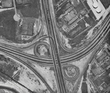
As the highway passes under Highway 427, it turns right and takes on an east-west orientation. It passes over Carlingview Drive, and begins to descend into a trench. It passes beneath Highway 27, two railway spurs, and Iron Street before returning to level grade. Around the interchange with Martin Grove Road, the freeway twists slightly to the left and right between factories and warehouses.[6]
At its eastern terminus, Highway 409 crosses Kipling Avenue and merges onto Highway 401 express and collector lanes, while the westbound collector lanes diverge and become the westbound lanes of Highway 409.[2]
History
Plans for Highway 409, originally known as the Belfield Expressway, were first presented in 1965 to the Mississauga council. In September 1968, three possible routes were submitted to the council. At the time, the town of Malton occupied the area of the planned expressway, having not yet been annexed as part of Mississauga. The 45 m (148 ft) wide strip of land would require the expropriation and demolition of 50 houses, as well as several businesses, a school, and two community parks. Citizens of the village formed a group to protest the freeway and to demand another route be taken. An above grade alternative, similar to the Gardiner Expressway was proposed, as well as a tunnel under the airport.[7]
However, at the same time, Toronto was embroiled in heated debate over the fate of its planned urban expressway system. When the Spadina Expressway was cancelled in 1971, the planned Belfield Expressway was completely revised. Instead of continuing northwest from Highway 427 and through Malton's four-corners at Derry Road and Airport Road towards Brampton, it would curve southwest and provide access to the developing Pearson Airport.[8]
Before plans for the new route were finalized, a flyover was built to provide access from Belfield Road to eastbound Highway 401, opening on October 7, 1968.[9] Because the lands on which the freeway was to be built were occupied, the province elected to apply to expropriate the right-of-way in April 1972.[10] Construction was underway by the end of the year, with the first contracts constructing the trench section near Highway 27. Structures, drainage and grading were completed west of Iron Street to Carlingview Avenue in 1974. In June of that year, contracts were awarded for the same work east of Iron Street to Highway 401. When this was completed in 1975, a paving contract was awarded from Carlingview Avenue to Highway 401.[11]
Highway 409 first opened to traffic by 1976, with temporary ramps at Carlingview Avenue acting as the western terminus. That year the final contracts were awarded to construct portions of the Highway 427 interchange and connect Highway 409 with the airport road system.[12] The entire freeway opened on August 25, 1978.[3]
The flyover ramp, which connects southbound Highway 427 with eastbound Highway 409 was constructed in the early 1990s. Prior to that, an at-grade intersection crossed the northbound lanes of Highway 427, controlled by a traffic signal. This signal had the longest cycle of any traffic light in Toronto during its years of operation.[13]
The portion of Highway 409 west of Highway 427 is owned and operated by the Greater Toronto Airports Authority (GTAA). Despite its private ownership, the section east of Airport Road is still considered a part of Highway 409.[1] The GTAA purchased this section of the highway in 2000 in order to rebuild the approaches to Toronto Pearson Airport.[4]
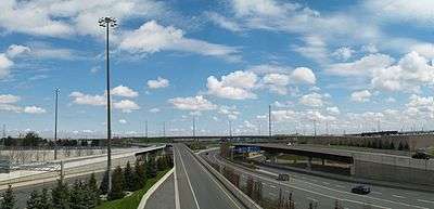
Until 2008, Highway 409 remained almost unchanged from its original construction. However, beginning on July 10, 2008, traffic access was restricted to the outermost lanes. The steel "W" guardrail and truss light posts in the median were replaced by an Ontario Tall Wall barrier with a high-mast lighting system. Construction was carried out over several years and was scheduled for completion on September 1, 2011.[14]
Exit list
The following table lists the major junctions along Highway 409, as noted by the Ministry of Transportation of Ontario.[1][2]
| Division | Location | km[1][2] | mi | Destinations | Notes |
|---|---|---|---|---|---|
| Peel|Regional Municipality of Peel|Peel | Mississauga | Westbound exit and eastbound entrance; no access to Viscount Road from Terminal 1 arrivals level or Terminal 3 | |||
| 0.0 | 0.0 | Regional Road 7 (Airport Road) | No eastbound exit; no access to Terminal 1 from westbound entrance; no access to Viscount Road and Network Road from eastbound entrance | ||
| Viscount Road | No westbound entrance; no access to Network Road | ||||
| Network Road | Eastbound exit and westbound entrance; no access to Viscount Road, Airport Road | ||||
| 1.4 | 0.87 | No westbound entrance from northbound 427 | |||
| Toronto | |||||
| 2.6 | 1.6 | Attwell Drive | Eastbound exit and westbound entrance | ||
| 4.1 | 2.5 | Martin Grove Road | |||
| 5.2 | 3.2 | Belfield Road, Kipling Avenue | Westbound exit and eastbound entrance | ||
| 5.6 | 3.5 | Eastbound exit and westbound entrance; Highway 409 merges onto Highway 401 eastbound | |||
| 1.000 mi = 1.609 km; 1.000 km = 0.621 mi | |||||
References
| Wikimedia Commons has media related to Ontario Highway 409. |
- 1 2 3 4 Ministry of Transportation of Ontario (2008). "Annual Average Daily Traffic (AADT) counts". Government of Ontario. Retrieved December 10, 2011.
- 1 2 3 4 5 6 Google (September 7, 2014). "Highway 409 length and route" (Map). Google Maps. Google. Retrieved September 7, 2014.
- 1 2 "New Shortcut Will Let Some 'Fly' to Airport". The Toronto Star. August 19, 1978. p. A6.
Highway 409, a new shortcut to Toronto International Airport, opens next Friday
|section=ignored (help) - 1 2 Mitchell, Bob (February 10, 2000). "Airport buys highway to create new gateway ; $280 million will be spent on better road access". Toronto Star. Torstar Corp. p. 1. Retrieved July 9, 2010.
|section=ignored (help) - ↑ Google (September 7, 2014). "Streetview: Speed limit drop to 60 km/h immediately west of Highway 427" (Map). Google Maps. Google. Retrieved September 7, 2014.
- ↑ Golden Horseshoe (Map). Cartography by MapArt. Peter Heiler Ltd. 2011. p. 107. § G2–H7. ISBN 978-1-55198-213-7.
- ↑ Hicks, Kathleen A. (2006). "Road Controversy - 1968". Malton: Farms to Flying (PDF). Friends of the Mississauga Library System. pp. 208–209. ISBN 0-9697873-9-1. Retrieved April 4, 2010.
- ↑ "New Terminal Expected to Ease Jams". The Toronto Star. June 9, 1972. p. 4.
|section=ignored (help) - ↑ Information Section (October 3, 1968). "Belfield Expressway Ramps Will be Open for Traffic" (Press release). Department of Highways.
- ↑ "New Shortcut Will Let Some 'Fly' to Airport". The Toronto Star. August 19, 1978. p. A6.
|section=ignored (help) - ↑ Construction Program: King's and Secondary Highways (Report). Ministry of Transportation and Communications. 1976–77. p. xvii.
- ↑ Construction Program: King's and Secondary Highways (Report). Ministry of Transportation and Communications. 1976–77. p. XIV.
- ↑ Gamester, George (June 22, 1981). "The Speed of Light". The Toronto Star. p. A3.
|section=ignored (help) - ↑ Ministry of Transportation of Ontario. "Contract 2008-2004". Government of Ontario. Archived from the original on July 6, 2011. Retrieved October 28, 2011.