Ohio State Route 14
| ||||
|---|---|---|---|---|
 | ||||
| Route information | ||||
| Maintained by ODOT | ||||
| Length: | 80.56 mi[1] (129.65 km) | |||
| Existed: | 1924 – present | |||
| Major junctions | ||||
| West end: |
| |||
| East end: |
| |||
| Location | ||||
| Counties: | Cuyahoga, Summit, Portage, Mahoning, Columbiana | |||
| Highway system | ||||
| ||||

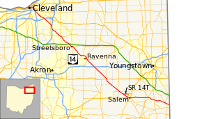
State Route 14, located in northeastern Ohio, runs from U.S. Route 6/U.S. Route 42/State Route 3 in Downtown Cleveland southeasterly to the Pennsylvania state line near East Palestine; Pennsylvania Route 51 continues southeasterly from there.
History
- 1924 – Original route established;[2] original alignment was along its current alignment from Bedford to Unity, SR 170’s current alignment from Unity to East Palestine, and SR 165’s current alignment from East Palestine to the Pennsylvania state line.[3]
- 1931 – Extended to Cleveland via the former alignment of SR 8.[3]
- 1946 – Eastern terminus moved to current location via the former alignment of SR 165.[3]
- 1951 – Aligned with US 224 from Deerfield to Canfield and with SR 46 from Canfield to Columbiana; Deerfield-Columbiana alignment changed to SR 14A (Alternate).[3]
- 1957 – Routed around Ravenna via bypass route.[3]
- 1966 – Freeway alignment from Bedford to current I-80 in Streetsboro was established and was dually signed with I-80.[3]
- 1969 – Canfield bypass (current SR 446) added.[3]
- 1971 – Bedford-Streetsboro freeway alignment designation changed to I-480/SR 14 (I-80 designation dropped).[3]
- 1984 – Deerfield-Columbiana reverted to SR 14 designation; SR 14A designation dropped; Canfield bypass signed SR 446.[3]
Major intersections
| County | Location | mi[1] | km | Exit | Destinations | Notes |
|---|---|---|---|---|---|---|
| Cuyahoga | Cleveland | 0.00 | 0.00 | Termini of US 42, US 322, US 422, SR 3, SR 8, SR 43, SR 87 | ||
| 0.60 | 0.97 | Eastern terminus of SR 10; exit 162B on I-77; exits 171A-B on I-90 | ||||
| 0.90 | 1.45 | Eastern terminus of concurrency with US 422 / SR 8 / SR 87; future concurrency terminus with SR 10 | ||||
| 2.20 | 3.54 | Exit 2A on I-490 | ||||
| 2.60 | 4.18 | Exit 161A on I-77 | ||||
| 5.50 | 8.85 | Eastern terminus of concurrency with SR 43 | ||||
| Garfield Heights | 7.70 | 12.39 | Exit 23 on I-480 | |||
| Maple Heights | 8.80 | 14.16 | No eastbound left turns to SR 17 east | |||
| Oakwood | 13.20 | 21.24 | 23 | Western terminus of concurrency with I-271 / I-480 | ||
| 14.70 | 23.66 | 21 | Eastern terminus of concurrency with I-271 | |||
| Summit | Twinsburg | 18.90 | 30.42 | 36 | ||
| 19.70 | 31.70 | 37 | ||||
| 24.34 | 39.17 | 41 | Frost Road | |||
| Portage | Streetsboro | 24.70 | 39.75 | 42 | Eastern terminus of I-480; exit 187 on I-80 / Turnpike | |
| 26.40 | 42.49 | Western terminus of concurrency with SR 303 | ||||
| 26.50 | 42.65 | |||||
| 26.70 | 42.97 | Eastern terminus of concurrency with SR 303 | ||||
| Ravenna | 33.50 | 53.91 | Western terminus of concurrency with SR 44 | |||
| 34.40 | 55.36 | |||||
| Ravenna Township | 35.90 | 57.78 | Former alignment of SR 5 | |||
| 36.30 | 58.42 | Interchange; eastern terminus of concurrency with SR 44 | ||||
| Edinburg Township | 40.80 | 65.66 | Exit 43 on I-76 | |||
| 41.60 | 66.95 | Northern terminus of SR 183 | ||||
| Deerfield Township | 48.70 | 78.38 | Traffic circle | |||
| Mahoning | Goshen Township | 56.00 | 90.12 | |||
| 56.60 | 91.09 | |||||
| 58.80 | 94.63 | Western terminus of SR 14T | ||||
| Columbiana | Salem | 61.10 | 98.33 | |||
| 61.70 | 99.30 | Western terminus of concurrency with SR 173 (former US 62) | ||||
| 62.30 | 100.26 | Western terminus of concurrency with SR 9 (former SR 45); eastern terminus of SR 173 | ||||
| 62.60 | 100.74 | Eastern terminus of concurrency with SR 9 (former US 62); northern terminus of SR 344 (former SR 45) | ||||
| Columbiana–Mahoning county line | Columbiana | 70.90 | 114.10 | Western terminus of concurrency with SR 46 | ||
| 77.40 | 124.56 | |||||
| Columbiana | 73.70 | 118.61 | Eastern terminus of concurrency with SR 46 | |||
| Unity Township | 78.90 | 126.98 | Western terminus of concurrency with SR 165 | |||
| 78.90 | 126.98 | Western terminus of concurrency SR 170 | ||||
| 79.50 | 127.94 | Eastern terminus of concurrency with SR 165 / SR 170 | ||||
| 81.20 | 130.68 | Continuation into Pennsylvania | ||||
1.000 mi = 1.609 km; 1.000 km = 0.621 mi
| ||||||
Route 14 Temporary
| |
|---|---|
| Location: | Salem |
| Length: | 2.73 mi[1] (4.39 km) |
State Route 14 Temporary (SR 14T) is a 2.73-mile-long[1] bypass around the city of Salem. SR 14T, a four-lane highway, begins at SR 14, Cleveland – East Liverpool Road, in Mahoning County. SR 14T crosses into Columbiana County and passes under County Route 61 and Goshen Road. SR 14T then has a diamond interchange with US 62 and SR 45. Exit ramps provide access from SR 14T to US 62 west and SR 45 south, and the two highways merge onto the SR 14T right-of-way as it continues past its terminus.
Although the SR 14T designation is unsigned, signs on the road read "TO US 62 / SR 45". The entire route is built to freeway standards with a speed limit of 65 miles per hour (105 km/h).
- Major intersections
The entire route is in Salem. All exits are unnumbered.
| County | mi[1] | km | Destinations | Notes | |
|---|---|---|---|---|---|
| Mahoning | 0.00 | 0.00 | At-grade intersection | ||
| Columbiana | 2.73 | 4.39 | Diamond interchange | ||
| Continuation beyond eastern terminus | |||||
| 1.000 mi = 1.609 km; 1.000 km = 0.621 mi | |||||
Route 14 Alternate
| |
|---|---|
| Location: | Deerfield–Columbiana |
| Existed: | 1951–1984 |
State Route 14A existed from 1951 to 1984 and followed what has been State Route 14 outside of that period between US 224 and SR 46 (see History section).
References
- 1 2 3 4 5 Ohio Department of Transportation. "Technical Services Straight Line Diagrams".
- ↑ Explanation of the Ohio State Highway System (The Unofficial Ohio State Highways Web Site) by John Simpson Archived May 23, 2006, at the Wayback Machine.
- 1 2 3 4 5 6 7 8 9 Route 14 (The Unofficial Ohio State Highways Web Site) by John Simpson Archived December 14, 2004, at the Wayback Machine.