Public Square, Cleveland
|
Cleveland Public Square | |
|
The Old Stone Church, Society for Savings Building, and Key Tower border Public Square, representing three eras of Cleveland history. | |
   | |
| Location |
Superior Avenue and Ontario Street Cleveland, Ohio 44106 |
|---|---|
| Coordinates | 41°29′59″N 81°41′38″W / 41.49972°N 81.69389°WCoordinates: 41°29′59″N 81°41′38″W / 41.49972°N 81.69389°W |
| Built | 1857 -1861 |
| NRHP Reference # | 75001361[1] |
| Added to NRHP | December 18, 1975 |
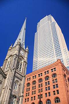
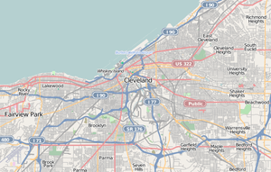
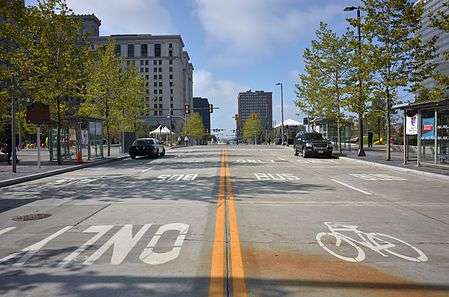
Public Square is the four-block central plaza of downtown Cleveland, Ohio. Based on an 18th-century New England model, it was part of the original 1796 town plat overseen by Moses Cleaveland, and remains today as an integral part of the city's center. The 10-acre (4.0 ha) square is centered on the former intersection of Superior Avenue and Ontario Street.[2] Cleveland's three tallest buildings, Key Tower, 200 Public Square and the Terminal Tower, face the square. Other Public Square landmarks include the 1855 Old Stone Church and the former Higbee's department store made famous in the 1983 film A Christmas Story, which reopened as the Horseshoe Casino Cleveland on May 14, 2012. The square was redeveloped in 2016 by the city into a more pedestrian-friendly environment with green space on the north half of the square, a hard surface on the south half of the square, and transit/bike lanes on a newly constructed Superior Avenue (which is closed to bus and motorist traffic.)
A 125-foot-tall (38 m) monument to Civil War soldiers and sailors occupies the southeast section of the square. City founder Moses Cleaveland and reformist mayor Tom L. Johnson each have statues on the square.
History

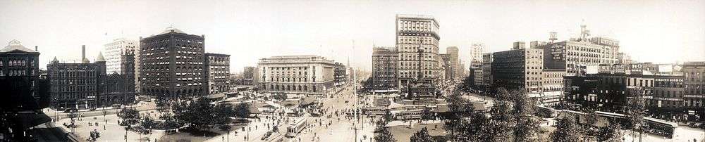
Public Square was part of the Connecticut Land Company's original plan for the city, which were overseen by Moses Cleaveland in the 1790s. The square is signature of the layout for early New England towns, which Cleveland was modeled after. While it initially served as a common pasture for settlers' animals, less than a century later Public Square was the height of modernity, when in 1879 it became the first street in the world to be lit with electric street lights, arc lamps designed by Cleveland native Charles F. Brush.[2] The square was added to the National Register of Historic Places on December 18, 1975.
A parking lot now faces the northwest quadrant of the square. A 12-story building, which was built on the spot in 1913, was demolished in 1990 to make way for the new Ameritrust Center, an 1,197-foot (365 m) skyscraper designed by New York's Kohn Pedersen Fox.[3] Before construction began, Ameritrust was acquired by Society Bank, which was also planning to construct and subsequently relocate to a new building on Public Square—Key Tower (formerly known as Society Center). Because Society did not need two skyscrapers, plans for the Ameritrust building across the square were scrapped.
Other buildings that face the square include 55 Public Square (1958), 75 Public Square (1915), the Society for Savings Building (1890), Metzenbaum Courthouse (1910), the former May Company department store (1914), the Park Building (1903), and the Renaissance Cleveland Hotel (1918). The demolished Cuyahoga Building (1893) and Williamson Building (1900) formerly stood on the site of 200 Public Square.
Public Square is often the site of political rallies and civic functions, including a free annual Independence Day concert by the Cleveland Orchestra. At the Balloonfest '86, close to 1.5 million balloons rose up from Public Square, engulfing the Terminal Tower and setting a world record.[4]
2010s renovation
In collaboration with landscape architect James Corner, the city in 2009 began to explore concepts for a redesign of the square.[5][6] In October 2011, Cleveland mayor Frank Jackson proposed his plan to redevelop the square, which included closing Superior Avenue and Ontario Street to create a large green space in the center.[7] On October 23, 2014, the Cleveland Landmarks Commission approved a plan which closed Ontario Street but kept Superior Avenue open to bus traffic, and kept the Soldiers' and Sailors' Monument prominent.[8][9] Ultimately it was decided to keep buses off Superior Avenue.[10] Cleveland City Council members have challenged this decision.[11]
The project began construction on March 9, 2015,[12] and was officially opened on June 30, 2016.[13]
The renovation of the square moved HealthLine bus stops outside of the square, which was later found to be in violation of a federal funding agreement.[14]
Transportation
Road
In total, ten U.S. and state routes meet at Public Square. It is the northern terminus of SR 3, SR 8, and SR 43; the western terminus of US 322, US 422, SR 14, and SR 87; and the northeastern terminus of US 42. US 6 passes through the square on Superior, and US 20 enters from the west on Superior and leaves via Euclid Avenue. US 21 also terminated at Public Square until that route was truncated to Marietta in 1967.[15][16]
Public transit
Public Square is adjacent to the Tower City–Public Square transit station, served by three RTA rail lines.
The HealthLine, a bus rapid transit line that travels along Euclid Avenue, terminates at Public Square. The RTA also ran several buses through the Public Square area, but suspended service on Superior Avenue after the 2016 renovation.[17][18] In November 2016, the city announced that the square would be permanently closed to buses, despite promises to re-open it.[10]
Gallery

See also
References
- ↑ "Ohio(OH), Cuyahoga County". National Register of Historic Places. Nationalregisterofhistoricplaces.com. Retrieved July 11, 2011.
- 1 2 "Public Square". The Encyclopedia of Cleveland History. Case Western Reserve University. July 30, 1999. Retrieved November 8, 2012.
- ↑ Emporis.com: Ameritrust Center. Accessed December 15, 2006.
- ↑ Kroll, John (August 15, 2011). "Balloonfest 1986, the spectacle that became a debacle: Cleveland Remembers". The Plain Dealer. Cleveland. Retrieved March 15, 2014.
- ↑ "Redesigning Public Square". Downtown Cleveland Alliance. Retrieved January 9, 2010.
- ↑ Litt, Steven (December 20, 2009). "Re-imagining Cleveland's Public Square". The Plain Dealer. Cleveland. Retrieved January 9, 2010.
- ↑ Litt, Steven (October 29, 2011). "Cleveland Mayor Frank Jackson envisions unified Public Square as symbol of greener city". The Plain Dealer. Cleveland. Retrieved November 23, 2011.
- ↑ Jarboe McFee, Michelle (October 23, 2014). "Public Square overhaul gets OK from Cleveland Landmarks Commission, after truce over Soldiers and Sailors Monument". The Plain Dealer. Cleveland. Retrieved October 24, 2014.
- ↑ "Cleveland Public Square". James Corner Field Operations. Retrieved October 24, 2014.
- 1 2 Christ, Ginger (November 15, 2016). "Cleveland opts to keep Public Square closed to buses". The Plain Dealer. Retrieved November 15, 2016.
- ↑ Atassi, Leila (November 30, 2016). "Cleveland Council assails city officials for banning buses from Public Square: Here are council's best questions". The Plain Dealer. Retrieved December 1, 2016.
- ↑ Litt, Steven (March 2, 2015). "It's official: Public Square renovation to launch Monday, March 9". The Plain Dealer. Cleveland. Retrieved March 3, 2015.
- ↑ Litt, Steven (June 30, 2016). "Ceremony Marks Official Opening of Public Square with Music, Dancing and Water". The Plain Dealer. Cleveland. Retrieved July 1, 2016.
- ↑ Christ, Ginger (August 16, 2016). "Federal agency says closed Public Square is a violation of funding deal". Cleveland.com. Retrieved August 18, 2016.
- ↑ Ohio Department of Highways (1967). Official Highway Map of Ohio (MrSID) (Map). Columbus: Ohio Department of Highways. OCLC 5673562, 7444249.
- ↑ U.S. Route Numbering Subcommittee (October 14, 1967). "U.S. Route Numbering Subcommittee Agenda Showing Action Taken by the Executive Committee" (PDF) (Report). Salt Lake City, UT: American Association of State Highway Officials. p. 6 – via Wikimedia Commons.
- ↑ Public Square Bus Stops (PDF) (Map). Greater Cleveland Regional Transit Authority. February 11, 2015. Retrieved August 18, 2016.
- ↑ Shaw, Meg (August 2, 2016). "RTA bus service to Public Square halted as city analyzes traffic patterns". ABC-5 Cleveland. Retrieved August 18, 2016.
Further reading
- Johannesen, Eric (1983). From Town to Tower. Western Reserve Historical Society. ISBN 978-0-911704-31-0.
External links
![]() Media related to Public Square, Cleveland at Wikimedia Commons
Media related to Public Square, Cleveland at Wikimedia Commons