Beloit, Ohio
| Beloit, Ohio | |
|---|---|
| Village | |
|
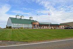
West Branch High School on Beloit-Snodes Road | |
 Location of Beloit, Ohio | |
 Location of Beloit in Mahoning County | |
| Coordinates: 40°55′22″N 80°59′50″W / 40.92278°N 80.99722°WCoordinates: 40°55′22″N 80°59′50″W / 40.92278°N 80.99722°W | |
| Country | United States |
| State | Ohio |
| County | Mahoning |
| Township | Smith |
| Area[1] | |
| • Total | 0.99 sq mi (2.56 km2) |
| • Land | 0.98 sq mi (2.54 km2) |
| • Water | 0.01 sq mi (0.03 km2) |
| Elevation[2] | 1,129 ft (344 m) |
| Population (2010)[3] | |
| • Total | 978 |
| • Estimate (2012[4]) | 962 |
| • Density | 998.0/sq mi (385.3/km2) |
| Time zone | Eastern (EST) (UTC-5) |
| • Summer (DST) | EDT (UTC-4) |
| ZIP code | 44609 |
| Area code(s) | 330 |
| FIPS code | 39-05410[5] |
| GNIS feature ID | 1064412[2] |
Beloit is a village in Mahoning County, Ohio, United States. The population was 978 at the 2010 census. It is part of the Youngstown-Warren-Boardman, OH-PA Metropolitan Statistical Area.
History
Beloit had its start in the late 1840s by the building of the railroad through that territory.[6] It was originally called Smithfield Station, and the name Beloit was adopted in 1863.[7] The name Beloit is a transfer from Beloit, Wisconsin.[8]
Geography
Beloit is located at 40°55′22″N 80°59′50″W / 40.92278°N 80.99722°W (40.922866, -80.997176).[9]
According to the United States Census Bureau, the village has a total area of 0.99 square miles (2.56 km2), of which 0.98 square miles (2.54 km2) is land and 0.01 square miles (0.03 km2) is water.[1]
Demographics
| Historical population | |||
|---|---|---|---|
| Census | Pop. | %± | |
| 1880 | 162 | — | |
| 1910 | 510 | — | |
| 1920 | 589 | 15.5% | |
| 1930 | 694 | 17.8% | |
| 1940 | 706 | 1.7% | |
| 1950 | 778 | 10.2% | |
| 1960 | 877 | 12.7% | |
| 1970 | 921 | 5.0% | |
| 1980 | 1,093 | 18.7% | |
| 1990 | 1,037 | −5.1% | |
| 2000 | 1,024 | −1.3% | |
| 2010 | 978 | −4.5% | |
| Est. 2015 | 939 | [10] | −4.0% |
2010 census
As of the census[3] of 2010, there were 978 people, 425 households, and 275 families residing in the village. The population density was 998.0 inhabitants per square mile (385.3/km2). There were 468 housing units at an average density of 477.6 per square mile (184.4/km2). The racial makeup of the village was 97.3% White, 0.3% African American, 0.1% Native American, 0.4% Asian, and 1.8% from two or more races. Hispanic or Latino of any race were 0.3% of the population.
There were 425 households of which 31.5% had children under the age of 18 living with them, 44.7% were married couples living together, 14.6% had a female householder with no husband present, 5.4% had a male householder with no wife present, and 35.3% were non-families. 31.5% of all households were made up of individuals and 16.4% had someone living alone who was 65 years of age or older. The average household size was 2.30 and the average family size was 2.86.
The median age in the village was 43.4 years. 23.8% of residents were under the age of 18; 5.9% were between the ages of 18 and 24; 21.9% were from 25 to 44; 26.3% were from 45 to 64; and 22.1% were 65 years of age or older. The gender makeup of the village was 47.6% male and 52.4% female.
2000 census
As of the census[5] of 2000, there were 1,024 people, 426 households, and 287 families residing in the village. The population density was 1,332.9 people per square mile (513.5/km²). There were 452 housing units at an average density of 588.4 per square mile (226.6/km²). The racial makeup of the village was 98.54% White, 0.29% African American, 0.10% Asian, 0.10% from other races, and 0.98% from two or more races. Hispanic or Latino of any race were 0.10% of the population.
There were 426 households out of which 28.9% had children under the age of 18 living with them, 49.1% were married couples living together, 14.8% had a female householder with no husband present, and 32.6% were non-families. 28.2% of all households were made up of individuals and 12.4% had someone living alone who was 65 years of age or older. The average household size was 2.40 and the average family size was 2.94.
In the village the population was spread out with 23.3% under the age of 18, 8.0% from 18 to 24, 26.4% from 25 to 44, 22.0% from 45 to 64, and 20.3% who were 65 years of age or older. The median age was 40 years. For every 100 females there were 83.8 males. For every 100 females age 18 and over, there were 80.5 males.
The median income for a household in the village was $32,279, and the median income for a family was $40,096. Males had a median income of $31,042 versus $19,615 for females. The per capita income for the village was $16,359. About 8.7% of families and 10.6% of the population were below the poverty line, including 17.4% of those under age 18 and 8.3% of those age 65 or over.
References
- 1 2 "US Gazetteer files 2010". United States Census Bureau. Archived from the original on 2012-07-14. Retrieved 2013-01-06.
- 1 2 "US Board on Geographic Names". United States Geological Survey. 2007-10-25. Retrieved 2008-01-31.
- 1 2 "American FactFinder". United States Census Bureau. Retrieved 2013-01-06.
- ↑ "Population Estimates". United States Census Bureau. Archived from the original on 2013-06-17. Retrieved 2013-06-17.
- 1 2 "American FactFinder". United States Census Bureau. Archived from the original on 2013-09-11. Retrieved 2008-01-31.
- ↑ Mack, Horace (1879). History of Columbiana County, Ohio: With Illustrations and Biographical Sketches of Some of Its Prominent Men and Pioneers. Unigraphic. p. 348.
- ↑ Sanderson, Thomas W. (1907). Twentieth Century History of Youngstown and Mahoning County. Biographical Publishing Company. p. 226.
- ↑ Overman, William Daniel (1958). Ohio Town Names. Akron, OH: Atlantic Press. p. 12.
- ↑ "US Gazetteer files: 2010, 2000, and 1990". United States Census Bureau. 2011-02-12. Retrieved 2011-04-23.
- ↑ "Annual Estimates of the Resident Population for Incorporated Places: April 1, 2010 to July 1, 2015". Retrieved July 2, 2016.
- ↑ "Census of Population and Housing". Census.gov. Archived from the original on May 11, 2015. Retrieved June 4, 2015.
Municipalities and communities of Mahoning County, Ohio, United States | ||
|---|---|---|
| Cities | 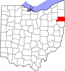 | |
| Villages | ||
| Townships | ||
| CDPs | ||
| Unincorporated communities |
| |
| Footnotes | ‡This populated place also has portions in an adjacent county or counties | |