Ohio State Route 17
| ||||
|---|---|---|---|---|
 | ||||
| Route information | ||||
| Maintained by ODOT | ||||
| Length: | 21.04 mi[1] (33.86 km) | |||
| Existed: | 1935[2][3] – present | |||
| Major junctions | ||||
| West end: |
| |||
| East end: |
| |||
| Location | ||||
| Counties: | Cuyahoga | |||
| Highway system | ||||
| ||||

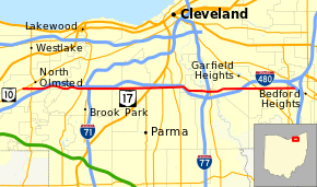
State Route 17 (SR 17) is an east–west highway in Northeast Ohio running from North Olmsted at State Route 10 to State Route 43 in Bedford Heights. The entire route has been paralleled by Interstate 480 and has junctions with this interstate via numerous cross streets such as Clague Road, Tiedeman Road, and Warrensville Center Road, and also via State Route 94 (State Road) and State Route 14 (Broadway Avenue). It also has two direct junctions with the interstate. State Route 17 provides access to many industrial and commercial areas in this area of Cleveland.
State Route 17 starts in Bedford Heights as Libby Road, Libby Road maintains its name until it hits Western Maple Heights where it becomes Granger Road. Granger Road goes from Maple Heights to Brooklyn Heights. At Brooklyn Heights before the 176 Jennings Freeway it becomes Brookpark Road. Brookpark Road maintains its name until it stops at North Olmsted near Great Northern Mall.
History
SR 17 was first signed as SR 43 in 1931, along the entire SR 17 route.[4][5] SR 17 was commissioned along its current route in 1935, the route went from U.S. Route 20 east to SR 43.[2][3] In 1938 SR 17 was moved onto Temporary SR 17, between US 20 and east of SR 252, in Brook Park.[6][7] Temporary SR 17 was removed between 1959 and 1961, moving SR 17 back to its current alignment.[8][9] In 1976 the section of road between US 20 and SR 10 was decommissioned.[10][11]
Major intersections
The entire route is in Cuyahoga County.
| Location | mi[1] | km | Destinations | Notes | |
|---|---|---|---|---|---|
| North Olmsted | 0.00 | 0.00 | |||
| 0.71 | 1.14 | ||||
| Cleveland | 3.78 | 6.08 | Direct eastbound exit from I-480; westbound entrance to I-480 via Grayton Road | ||
| Cleveland–Brook Park line | 4.51 | 7.26 | Western end of OH 237 concurrency | ||
| 4.59 | 7.39 | Eastern end of OH 237 concurrency | |||
| Brook Park | 5.11 | 8.22 | Northern terminus of SR 291 | ||
| 6.63 | 10.67 | Exit 12 on I-480; westbound movements via West 130th Street | |||
| Cleveland–Parma line | 9.84 | 15.84 | |||
| 10.78 | 17.35 | ||||
| 11.57 | 18.62 | Western end of OH 176 concurrency | |||
| 11.82 | 19.02 | Eastern end of OH 176 concurrency; ramps to Jennings Freeway | |||
| Brooklyn Heights | 12.28 | 19.76 | Exit 17B on I-480 | ||
| Valley View | 14.51 | 23.35 | Cloverleaf interchange | ||
| Garfield Heights | 16.92 | 27.23 | No eastbound exit; exit 22 on I-480 | ||
| Maple Heights | 18.12 | 29.16 | |||
| Bedford Heights | 20.44 | 32.89 | |||
| 20.99 | 33.78 | Western end of OH 43 concurrency | |||
| 21.04 | 33.86 | Eastern terminus of OH 43 concurrency | |||
1.000 mi = 1.609 km; 1.000 km = 0.621 mi
| |||||
References
- 1 2 Ohio Department of Transportation. "Technical Services Straight Line Diagrams" (PDF). Retrieved December 10, 2013.
- 1 2 Ohio Department of Highways (1934). Map of Ohio Showing State Routes (MrSID) (Map). 1:760,320. Columbus: Ohio Department of Highways. OCLC 5673562, 7236991. Retrieved September 20, 2013.
- 1 2 Ohio Department of Highways (1935). Official Highway Map of Ohio (MrSID) (Map). Columbus: Ohio Department of Highways. OCLC 5673562, 54667348. Retrieved September 20, 2013.
- ↑ Ohio Department of Highways (1930). Map of Ohio Showing State Routes (MrSID) (Map). 1:760,320. Columbus: Ohio Department of Highways. OCLC 5673562, 7237073. Retrieved September 20, 2013.
- ↑ Ohio Department of Highways (1931). Map of Ohio Showing State Routes (MrSID) (Map). 1:760,320. Columbus: Ohio Department of Highways. OCLC 5673562, 7231737. Retrieved September 20, 2013.
- ↑ Ohio Department of Highways (1937). Official Highway Map of Ohio (MrSID) (Map). 1:633,600. Columbus: Ohio Department of Highways. OCLC 5673562, 16960304. Retrieved September 20, 2013.
- ↑ Ohio Department of Highways (1938). Official Highway Map of Ohio (MrSID) (Map). 1:633,600. Columbus: Ohio Department of Highways. OCLC 5673562, 7453129. Retrieved September 20, 2013.
- ↑ Ohio Department of Highways (1959). Official Highway Map of Ohio (MrSID) (Map) (1959–60 ed.). 1:633,600. Columbus: Ohio Department of Highways. OCLC 5673562, 13687960. Retrieved September 20, 2013.
- ↑ Ohio Department of Highways (1961). Official Highway Map of Ohio (MrSID) (Map). 1:633,600. Columbus: Ohio Department of Highways. OCLC 5673562, 54667348. Retrieved September 20, 2013.
- ↑ Ohio Department of Transportation (1975). Official Highway Map of Ohio (MrSID) (Map). 1:554,400. Columbus: Ohio Department of Transportation. OCLC 5673562. Retrieved September 20, 2013.
- ↑ Ohio Department of Transportation (1976). Official Highway Map of Ohio (MrSID) (Map). 1:554,400. Columbus: Ohio Department of Transportation. OCLC 5673562, 13655720, 35168139. Retrieved September 20, 2013.