| [3] |
Name on the Register[4] |
Image |
Date listed[5] |
Location |
City or town |
Description |
|---|
| 1 |
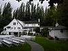
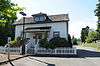
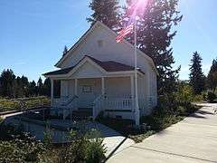
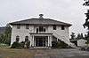
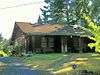
Bates-Tanner Farm |
|
000000001995-03-09-0000March 9, 1995
(#95000189) |
3420 240th St. SE
47°46′50″N 122°11′06″W / 47.780556°N 122.185°W / 47.780556; -122.185 (Bates-Tanner Farm) |
Bothell |
Bothell MPS
|
| 2 |
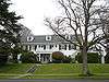
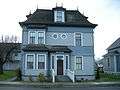
Butler-Jackson House |
|
000000001998-05-14-0000May 14, 1998
(#97000494) |
1703 Grand Ave.
47°59′16″N 122°12′40″W / 47.987778°N 122.211111°W / 47.987778; -122.211111 (Butler-Jackson House) |
Everett |
|
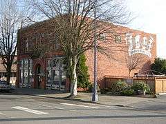
| 3 |
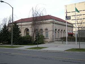
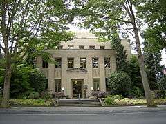
Andrew Carnegie Library |
|
000000001973-04-24-0000April 24, 1973
(#73001887) |
118 5th Ave., N.
47°48′40″N 122°22′32″W / 47.811111°N 122.375556°W / 47.811111; -122.375556 (Andrew Carnegie Library) |
Edmonds |
Carnegie Libraries of Washington TR (AD)
|
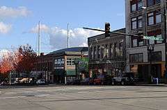
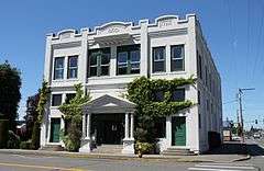
| 4 |
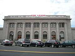
Commerce Building |
|
000000001992-10-01-0000October 1, 1992
(#92001290) |
1801 Hewitt Ave.
47°58′47″N 122°12′16″W / 47.979722°N 122.204444°W / 47.979722; -122.204444 (Commerce Building) |
Everett |
|
| 5 |
Community Center and War Memorial Building |
|
000000001979-02-26-0000February 26, 1979
(#79002554) |
1611 Everett Ave.
47°58′56″N 122°12′22″W / 47.982222°N 122.206111°W / 47.982222; -122.206111 (Community Center and War Memorial Building) |
Everett |
|
| 6 |
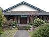
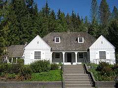
Darrington Ranger Station |
|
000000001991-03-06-0000March 6, 1991
(#91000155) |
1405 Emmens St.
48°15′40″N 121°36′09″W / 48.261111°N 121.6025°W / 48.261111; -121.6025 (Darrington Ranger Station) |
Darrington |
|
| 7 |
EQUATOR (schooner) |
|
000000001972-04-14-0000April 14, 1972
(#72001281) |
14th St. Yacht Basin
47°59′52″N 122°12′50″W / 47.997778°N 122.213889°W / 47.997778; -122.213889 (EQUATOR (schooner)) |
Everett |
|
| 8 |
Everett Carnegie Library |
|
000000001975-12-06-0000December 6, 1975
(#75001868) |
3001 Oakes Ave.
47°58′40″N 122°12′10″W / 47.977778°N 122.202778°W / 47.977778; -122.202778 (Everett Carnegie Library) |
Everett |
Carnegie Libraries of Washington TR (AD)
|
| 9 |
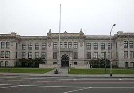
Everett City Hall |
|
000000001990-05-02-0000May 2, 1990
(#90000674) |
3002 Wetmore Ave.
47°58′39″N 122°12′22″W / 47.9775°N 122.206111°W / 47.9775; -122.206111 (Everett City Hall) |
Everett |
Officially renamed the Mayor William E. Moore building in 2012.
|
| 10 |
Everett Fire Station No. 2 |
|
000000001990-05-02-0000May 2, 1990
(#90000673) |
2801 Oakes Ave.
47°58′50″N 122°12′10″W / 47.980556°N 122.202778°W / 47.980556; -122.202778 (Everett Fire Station No. 2) |
Everett |
|
| 11 |
Everett High School |
|
000000001997-06-04-0000June 4, 1997
(#97000493) |
2400 Colby Ave.
47°59′07″N 122°12′29″W / 47.985278°N 122.208056°W / 47.985278; -122.208056 (Everett High School) |
Everett |
|
| 12 |
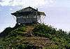
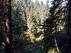
Evergreen Mountain Lookout |
|
000000001987-07-14-0000July 14, 1987
(#87001187) |
Skykomish Ranger District on SW ridgecrest of Evergreen Mountain
47°50′12″N 121°15′46″W / 47.836667°N 121.262778°W / 47.836667; -121.262778 (Evergreen Mountain Lookout) |
Skykomish |
|
| 13 |
Floral Hall |
|
000000001990-04-26-0000April 26, 1990
(#90000671) |
Forest Park
47°57′33″N 122°13′07″W / 47.959167°N 122.218611°W / 47.959167; -122.218611 (Floral Hall) |
Everett |
|
| 14 |
Green Mountain Lookout |
Upload image |
000000001988-02-22-0000February 22, 1988
(#88000117) |
Darrington Ranger District
Coordinates missing |
Darrington |
|
| 15 |
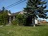
Grimm House |
|
000000001995-03-09-0000March 9, 1995
(#95000191) |
2002 Hartford Dr.
48°00′57″N 122°03′44″W / 48.015833°N 122.062222°W / 48.015833; -122.062222 (Grimm House) |
Lake Stevens |
|
| 16 |
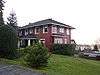
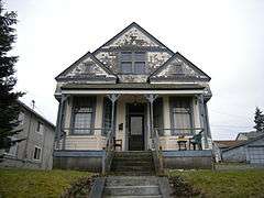
Roland Hartley House |
|
000000001986-05-02-0000May 2, 1986
(#86000958) |
2320 Rucker Ave.
47°59′12″N 122°12′37″W / 47.986667°N 122.210278°W / 47.986667; -122.210278 (Roland Hartley House) |
Everett |
|
| 17 |
Hewitt Avenue Historic District |
|
000000002010-12-13-0000December 13, 2010
(#10001020) |
1620-1915 Hewitt Ave. and portions of Wetmore, Rockefeller, Oakes, and Lombard Ave.
47°58′45″N 122°12′19″W / 47.979167°N 122.205278°W / 47.979167; -122.205278 (Hewitt Avenue Historic District) |
Everett |
|
| 18 |
Horseshoe Bend Placer Claim |
|
000000001981-05-07-0000May 7, 1981
(#81000590) |
North of Sultan
47°55′41″N 121°48′20″W / 47.928056°N 121.805556°W / 47.928056; -121.805556 (Horseshoe Bend Placer Claim) |
Sultan |
|
| 19 |
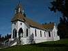
Indian Shaker Church |
|
000000001976-05-04-0000May 4, 1976
(#76001910) |
West of Marysville, Tulalip Reservation, N. Meridan Ave.
48°02′32″N 122°13′52″W / 48.042222°N 122.231111°W / 48.042222; -122.231111 (Indian Shaker Church) |
Marysville |
An Indian Shaker Church denomination building, presumably
|
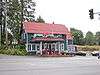
| 20 |
Keeler's Korner |
|
000000001982-04-29-0000April 29, 1982
(#82004287) |
16401 U.S. 99
47°51′00″N 122°17′30″W / 47.85°N 122.291667°W / 47.85; -122.291667 (Keeler's Korner) |
Lynnwood |
NRHP listing #51549. Gas station & grocery store dating from 1927.
|
| 21 |
Marysville Opera House |
|
000000001982-02-25-0000February 25, 1982
(#82004288) |
1225 3rd St.
48°03′04″N 122°10′46″W / 48.051111°N 122.179444°W / 48.051111; -122.179444 (Marysville Opera House) |
Marysville |
|
| 22 |
McCabe Building |
|
000000001977-10-21-0000October 21, 1977
(#77001359) |
3120 Hewitt Ave.
47°58′44″N 122°11′15″W / 47.978889°N 122.1875°W / 47.978889; -122.1875 (McCabe Building) |
Everett |
|
| 23 |
Miners Ridge Lookout |
Upload image |
000000001987-07-19-0000July 19, 1987
(#87001183) |
Darrington Ranger District in Glacier Peak Wilderness area 5 miles (8.0 km) west of Pacific Crest trail
48°12′26″N 121°01′41″W / 48.207222°N 121.028056°W / 48.207222; -121.028056 (Miners Ridge Lookout) |
Darrington |
|
| 24 |
Monte Cristo Hotel |
|
000000001976-06-03-0000June 3, 1976
(#76001907) |
1507 Wall St.
47°58′41″N 122°12′30″W / 47.978056°N 122.208333°W / 47.978056; -122.208333 (Monte Cristo Hotel) |
Everett |
|
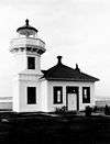
| 25 |
Mukilteo Light Station |
|
000000001977-10-21-0000October 21, 1977
(#77001360) |
WA 525
47°56′56″N 122°18′18″W / 47.948889°N 122.305°W / 47.948889; -122.305 (Mukilteo Light Station) |
Mukilteo |
|
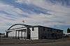
| 26 |
Naval Auxiliary Air Station-Arlington |
|
000000001995-06-30-0000June 30, 1995
(#95000802) |
18204 59th Dr. NE., Arlington Municipal Airport
Boundary increase (listed 000000002012-03-27-0000March 27, 2012, refnum 12000163): 18204 59th Dr., NE
48°09′49″N 122°09′33″W / 48.163611°N 122.159167°W / 48.163611; -122.159167 (Naval Auxiliary Air Station-Arlington) |
Arlington |
|
| 27 |
North Coast Casket Company Building |
|
000000002006-08-08-0000August 8, 2006
(#06000700) |
1210 W. Marine View Dr.
48°00′10″N 122°12′54″W / 48.002778°N 122.215°W / 48.002778; -122.215 (North Coast Casket Company Building) |
Everett |
Now demolished. Deconstructed in 2011 by Port of Everett after lengthy battle on preservation vs. site redevelopment.[6] Commonly known as the Collins Building.
|
| 28 |
North Creek School |
|
000000001994-05-19-0000May 19, 1994
(#94000406) |
22711 31st Ave. SE.
47°47′30″N 122°10′48″W / 47.791667°N 122.18°W / 47.791667; -122.18 (North Creek School) |
Bothell |
|
| 29 |
D. O. Pearson House |
|
000000001973-05-25-0000May 25, 1973
(#73001890) |
Pearson and Market Sts.
48°14′31″N 122°22′11″W / 48.241944°N 122.369722°W / 48.241944; -122.369722 (D. O. Pearson House) |
Stanwood |
NRHP listing #73001890 Now part of the Stanwood Area History Museum.
|
| 30 |
Point Elliott Treaty Monument |
|
000000002004-04-14-0000April 14, 2004
(#04000316) |
Jct. of Lincoln Ave. and 3rd St.
47°56′54″N 122°18′12″W / 47.948333°N 122.303333°W / 47.948333; -122.303333 (Point Elliott Treaty Monument) |
Mukilteo |
|
| 31 |
Red Men Hall |
|
000000001973-04-13-0000April 13, 1973
(#73001889) |
Index Ave. at 6th St.
47°49′14″N 121°33′06″W / 47.820556°N 121.551667°W / 47.820556; -121.551667 (Red Men Hall) |
Index |
Collapsed January 1, 2009
|
| 32 |
Rucker Hill Historic District |
|
000000001989-11-08-0000November 8, 1989
(#89000399) |
Roughly bounded by 32nd, Tulalip Ave., Bell Ave., Snohomish Ave., Laurel, and Warren
47°58′23″N 122°13′14″W / 47.973056°N 122.220556°W / 47.973056; -122.220556 (Rucker Hill Historic District) |
Everett |
|
| 33 |
Rucker House |
|
000000001975-12-04-0000December 4, 1975
(#75001869) |
412 Laurel Dr.
47°58′23″N 122°13′21″W / 47.973056°N 122.2225°W / 47.973056; -122.2225 (Rucker House) |
Everett |
|
| 34 |
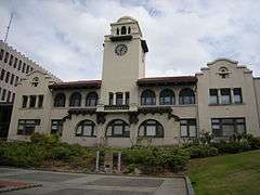
Snohomish County Courthouse |
|
000000001975-12-06-0000December 6, 1975
(#75001870) |
Wetmore Ave. between Wall St. and Pacific Ave.
47°58′39″N 122°12′19″W / 47.9775°N 122.205278°W / 47.9775; -122.205278 (Snohomish County Courthouse) |
Everett |
|
| 35 |
Snohomish Historic District |
|
000000001974-10-22-0000October 22, 1974
(#74001978) |
Roughly bounded by Ave. E, 5th St., Union Ave., Northern Pacific RR and Snohomish River
47°54′46″N 122°05′36″W / 47.912778°N 122.093333°W / 47.912778; -122.093333 (Snohomish Historic District) |
Snohomish |
|
| 36 |
St. Anne's Roman Catholic Church |
|
000000001976-06-18-0000June 18, 1976
(#76001911) |
West of Marysville on Mission Beach Rd.
48°03′43″N 122°16′34″W / 48.061944°N 122.276111°W / 48.061944; -122.276111 (St. Anne's Roman Catholic Church) |
Marysville |
|
| 37 |
Stanwood IOOF Public Hall |
|
000000002002-02-21-0000February 21, 2002
(#02000087) |
27128 102nd Ave. NW
48°14′35″N 122°22′11″W / 48.243056°N 122.369722°W / 48.243056; -122.369722 (Stanwood IOOF Public Hall) |
Stanwood |
Now Floyd Norgaard Cultural Center.
|
| 38 |
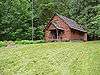
Suiattle Guard Station |
|
000000001990-12-18-0000December 18, 1990
(#90001865) |
Suiattle River east of Buck Cr., Mt. Baker-Snoqualmie NF
48°15′42″N 121°19′04″W / 48.261667°N 121.317778°W / 48.261667; -121.317778 (Suiattle Guard Station) |
Darrington |
|
| 39 |
Swalwell Block and Adjoining Commercial Buildings |
|
000000001976-05-17-0000May 17, 1976
(#76001908) |
2901-2909 and 2915 Hewitt Ave.
47°58′47″N 122°11′26″W / 47.979722°N 122.190556°W / 47.979722; -122.190556 (Swalwell Block and Adjoining Commercial Buildings) |
Everett |
|
| 40 |
Swalwell Cottage |
|
000000001978-11-28-0000November 28, 1978
(#78002773) |
2712 Pine St.
47°58′53″N 122°11′29″W / 47.981389°N 122.191389°W / 47.981389; -122.191389 (Swalwell Cottage) |
Everett |
|
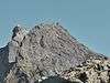
| 41 |
Three Fingers Lookout |
|
000000001987-07-14-0000July 14, 1987
(#87001190) |
Darrington Ranger District on the southernmost peak
48°10′12″N 121°41′11″W / 48.17°N 121.686389°W / 48.17; -121.686389 (Three Fingers Lookout) |
Darrington |
|
| 42 |
Trafton School |
|
000000002006-10-30-0000October 30, 2006
(#06000730) |
12616 Jim Creek Rd.
48°14′19″N 122°03′36″W / 48.238611°N 122.06°W / 48.238611; -122.06 (Trafton School) |
Arlington |
Rural Public Schools of Washington State MPS
|
| 43 |
Tulalip Indian Agency Office |
|
000000001976-05-03-0000May 3, 1976
(#76001912) |
3901 Mission Beach Rd., Tulalip Reservation
48°03′56″N 122°17′04″W / 48.065556°N 122.284444°W / 48.065556; -122.284444 (Tulalip Indian Agency Office) |
Marysville |
|
| 44 |
U.S. Post Office and Customshouse |
|
000000001976-06-22-0000June 22, 1976
(#76001909) |
3006 Colby Ave.
47°58′40″N 122°12′27″W / 47.977778°N 122.2075°W / 47.977778; -122.2075 (U.S. Post Office and Customshouse) |
Everett |
Also known as the Federal Building and as Peed Hall (from a recent period when it was owned by Cogswell College).
|
| 45 |
Verlot Ranger Station-Public Service Center |
|
000000001986-04-08-0000April 8, 1986
(#86000839) |
Mt. Baker, Snoqualmie National Forest
48°05′38″N 121°46′46″W / 48.093889°N 121.779444°W / 48.093889; -121.779444 (Verlot Ranger Station-Public Service Center) |
Granite Falls |
NRHP listing #86000839
|
| 46 |
Weyerhaeuser Office Building |
|
000000001986-05-14-0000May 14, 1986
(#86001079) |
1710 W. Marine View Dr.
47°59′43″N 122°12′47″W / 47.995278°N 122.213056°W / 47.995278; -122.213056 (Weyerhaeuser Office Building) |
Everett |
|
| 47 |
Winningham Farm |
|
000000001994-05-13-0000May 13, 1994
(#94000418) |
3214 228th St. SE.
47°47′28″N 122°10′55″W / 47.791111°N 122.181944°W / 47.791111; -122.181944 (Winningham Farm) |
Bothell |
|