National Register of Historic Places listings in Kitsap County, Washington
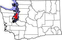
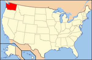
Location of Kitsap County in Washington
This is a list of the National Register of Historic Places listings in Kitsap County, Washington.
This is intended to be a complete list of the properties and districts on the National Register of Historic Places in Kitsap County, Washington, United States. Latitude and longitude coordinates are provided for many National Register properties and districts; these locations may be seen together in a map.[1]
There are 19 properties and districts listed on the National Register in the county. Another property was once listed but has been removed.
- This National Park Service list is complete through NPS recent listings posted December 2, 2016.[2]
Current listings
| [3] | Name on the Register | Image | Date listed[4] | Location | City or town | Description |
|---|---|---|---|---|---|---|
| 1 | Agate Pass Bridge |  |
(#95000625) |
WA 305 over Agate Passage 47°42′45″N 122°33′54″W / 47.7125°N 122.565°W |
Suquamish | Built in 1950. Bridges of Washington State MPS |
| 2 | Bremerton Elks Temple Lodge No. 1181 Building | 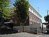 |
(#95000192) |
285 Fifth St. 47°34′00″N 122°37′31″W / 47.566667°N 122.625278°W |
Bremerton | |
| 3 | Camp Major Hopkins |  |
(#05001351) |
900 Park Ave. NE 47°37′58″N 122°29′43″W / 47.632778°N 122.495278°W |
Bainbridge Island | Built in 1935. Currently known as Camp Yeomalt. |
| 4 | Coder-Coleman House | 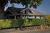 |
(#09000367) |
904 Highland Ave. 47°34′11″N 122°37′28″W / 47.569617°N 122.624506°W |
Bremerton | |
| 5 | Filipino-American Community Hall |  |
(#95000193) |
7566 NE High School Rd. 47°38′11″N 122°33′09″W / 47.636389°N 122.5525°W |
Bainbridge Island | Built in 1930. |
| 6 | Fort Ward Historic District | 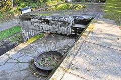 |
(#78002759) |
S of Winslow 47°34′52″N 122°31′42″W / 47.581111°N 122.528333°W |
Bainbridge Island | Built in 1890. |
| 7 | Hospital Reservation Historic District |  |
(#88003052) |
Roughly bounded by Mahan Ave., Hoogewerf Rd., Decatur Ave., and Dewey St. 47°33′44″N 122°38′38″W / 47.562222°N 122.643889°W |
Bremerton | |
| 8 | Jackson Hall Memorial Community Hall | 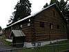 |
(#95001036) |
9161 Washington Ave. 47°38′44″N 122°40′50″W / 47.645556°N 122.680556°W |
Silverdale | Also known as Silverdale Scout Hall. |
| 9 | Marine Reservation Historic District | 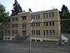 |
(#88003051) |
Bounded by Cole St., Dewey St., Decatur Ave., and Doyen St. 47°33′48″N 122°38′43″W / 47.563333°N 122.645278°W |
Bremerton | |
| 10 | Masonic Hall-Port Orchard |  |
(#10000254) |
202 Sidney Ave. 47°32′28″N 122°38′12″W / 47.541058°N 122.636572°W |
Port Orchard | |
| 11 | Navy Yard Puget Sound |  |
(#92001883) |
N shore of Sinclair Inlet 47°33′32″N 122°38′17″W / 47.5589°N 122.6381°W |
Bremerton | This shipyard was the primary repair destination for damaged battleships during World War II. Of the eight ships bombed in the Japanese attack on Pearl Harbor, five were repaired here. |
| 12 | Charles F. Nelson House | 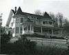 |
(#73001879) |
Corner of Nelson and Crescent Valley Rds. 47°25′06″N 122°32′25″W / 47.418333°N 122.540278°W |
Olalla | |
| 13 | Officers' Row Historic District | 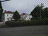 |
(#88003054) |
Roughly bounded by Mahan Ave., Decatur Ave., and Coghlan Rd. 47°33′44″N 122°38′20″W / 47.562222°N 122.638889°W |
Bremerton | |
| 14 | Old-Man-House Site (45KP2) | 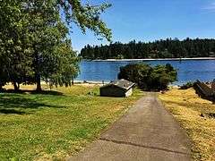 |
(#89002299) |
Address Restricted |
Suquamish | |
| 15 | Point No Point Light | 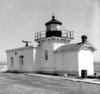 |
(#78002758) |
E of Hansville 47°54′45″N 122°31′32″W / 47.9125°N 122.525556°W |
Hansville | Built in 1879. |
| 16 | Port Gamble Historic District | 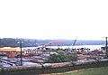 |
(#66000746) |
NW end of Kitsap Peninsula near entrance to Hood Canal, Puget Sound 47°51′18″N 122°35′02″W / 47.855°N 122.5839°W |
Port Gamble | This company town was founded in 1853, and ran the longest running timber mill in the US, which just closed in 1995. Seattle architect Charles Bebb designed many of the town's buildings.[5] |
| 17 | Puget Sound Radio Station Historic District | |
(#88003053) |
Roughly bounded by Mahan Ave., Coghlan Rd., and Cottman Rd. 47°33′48″N 122°38′23″W / 47.563333°N 122.639722°W |
Bremerton | |
| 18 | Shelbanks | .jpg) |
(#04000160) |
1520 Shorewood Dr. 47°34′33″N 122°40′53″W / 47.575833°N 122.681389°W |
Bremerton | Also known as Kean Cabin. |
| 19 | US Post Office-Bremerton Main | 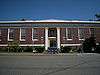 |
(#91000638) |
602 Pacific Ave. 47°34′04″N 122°37′31″W / 47.567778°N 122.625278°W |
Bremerton |
Former listing
| [3] | Name on the Register | Image | Date listed | Date removed | Location | City or town | Summary |
|---|---|---|---|---|---|---|---|
| 1 | Hotel Sidney | Upload image | (#73001880) | 700 Prospect St. |
Port Orchard | Also known as Navy View Apartments. Destroyed by fire. Replica stands on original foundation. |
References
- ↑ The latitude and longitude information provided in this table was derived originally from the National Register Information System, which has been found to be fairly accurate for about 99% of listings. For about 1% of NRIS original coordinates, experience has shown that one or both coordinates are typos or otherwise extremely far off; some corrections may have been made. A more subtle problem causes many locations to be off by up to 150 yards, depending on location in the country: most NRIS coordinates were derived from tracing out latitude and longitudes off of USGS topographical quadrant maps created under the North American Datum of 1927, which differs from the current, highly accurate WGS84 GPS system used by most on-line maps. Chicago is about right, but NRIS longitudes in Washington are higher by about 4.5 seconds, and are lower by about 2.0 seconds in Maine. Latitudes differ by about 1.0 second in Florida. Some locations in this table may have been corrected to current GPS standards.
- ↑ "National Register of Historic Places: Weekly List Actions". National Park Service, United States Department of the Interior. Retrieved on December 2, 2016.
- 1 2 Numbers represent an ordering by significant words. Various colorings, defined here, differentiate National Historic Landmarks and historic districts from other NRHP buildings, structures, sites or objects.
- ↑ The eight-digit number below each date is the number assigned to each location in the National Register Information System database, which can be viewed by clicking the number.
- ↑ Carlson 2003, p. 232

| Topics | |
|---|---|
| Lists by states |
|
| Lists by insular areas | |
| Lists by associated states | |
| Other areas | |
| |
Municipalities and communities of Kitsap County, Washington, United States | ||
|---|---|---|
| Cities | | |
| CDPs | ||
| Other unincorporated communities | ||
| Indian reservation | ||
| Wikimedia Commons has media related to National Register of Historic Places in Kitsap County, Washington. |
This article is issued from Wikipedia - version of the 6/2/2016. The text is available under the Creative Commons Attribution/Share Alike but additional terms may apply for the media files.