National Register of Historic Places listings in Spokane County, Washington
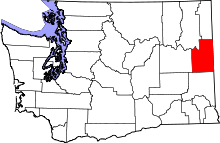
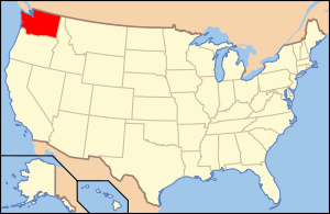
Location of Spokane County in Washington
This is a list of the National Register of Historic Places listings in Spokane County, Washington.
This is intended to be a complete list of the properties and districts on the National Register of Historic Places in Spokane County, Washington, United States. Latitude and longitude coordinates are provided for many National Register properties and districts; these locations may be seen together in a Google map.[1]
There are 145 properties and districts listed on the National Register in the county. 123 of these properties and districts are located within the city of Spokane, while the remaining 22 properties and districts are located elsewhere. Another 2 properties were once listed but have been removed.
- This National Park Service list is complete through NPS recent listings posted November 25, 2016.[2]
Listings (exclusive of Spokane)
| [3] | Name on the Register | Image | Date listed[4] | Location | City or town | Description |
|---|---|---|---|---|---|---|
| 1 | American Firebrick Company | 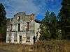 |
(#82004289) |
WA 27 47°33′33″N 117°12′31″W / 47.559167°N 117.208611°W |
Mica | |
| 2 | California Ranch | 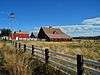 |
(#80004010) |
E of Mica on Jackson and Belmont Rds. 47°33′29″N 117°11′38″W / 47.558056°N 117.193889°W |
Mica | |
| 3 | Central Schoolhouse (District No. 49) | 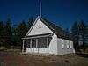 |
(#92001040) |
Jct. of Ritchey and Four Mound Rds., NW corner 47°47′19″N 117°42′49″W / 47.788568°N 117.713635°W |
Nine Mile Falls | Rural Public Schools of Washington State MPS |
| 4 | Cheney Interurban Depot | 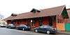 |
(#79002555) |
505 2nd St. 47°29′17″N 117°34′32″W / 47.488185°N 117.575573°W |
Cheney | |
| 5 | Cheney Odd Fellows Hall | 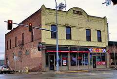 |
(#90001639) |
321 First St. 47°29′12″N 117°34′33″W / 47.486641°N 117.575773°W |
Cheney | |
| 6 | City of Cheney Historic District | 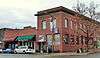 |
(#01000062) |
Roughly bounded by Fifth St., C St., Front St., and F St. 47°29′18″N 117°34′35″W / 47.488259°N 117.576418°W |
Cheney | |
| 7 | Dybdall Gristmill | Upload image | (#76001913) |
10 mi. S of Cheney at Chapman Lake 47°21′13″N 117°33′56″W / 47.353611°N 117.565556°W |
Cheney | |
| 8 | Hallett House | Upload image | (#76001915) |
E. 623 Lake, SE 47°34′24″N 117°40′25″W / 47.573333°N 117.673611°W |
Medical Lake | |
| 9 | Ham-McEachern House | 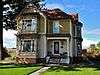 |
(#78002774) |
Pine and 5th Sts. 47°16′59″N 117°09′24″W / 47.283056°N 117.156667°W |
Latah | |
| 10 | Italian Rock Ovens | Upload image | (#76001914) |
S of Cheney 47°26′58″N 117°35′39″W / 47.449444°N 117.594167°W |
Cheney | |
| 11 | Latah School | 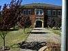 |
(#02001489) |
515 North Main 47°17′01″N 117°09′19″W / 47.283611°N 117.155278°W |
Latah | Rural Public Schools of Washington State MPS |
| 12 | David Lowe House | 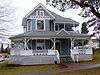 |
(#83004264) |
306 F St. 47°29′16″N 117°34′41″W / 47.487827°N 117.578004°W |
Cheney | |
| 13 | Marshall Bridge | 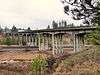 |
(#95000631) |
Cheney-Spokane Rd. over the SP & S Railroad tracks 47°34′00″N 117°29′36″W / 47.566768°N 117.493285°W |
Marshall | Bridges of Washington State MPS |
| 14 | Millwood Historic District | 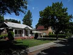 |
(#01000064) |
Roughly bounded by Argonne and Sargent Rds., and by Euclid and Liberty Aves. 47°41′14″N 117°17′05″W / 47.687222°N 117.284722°W |
Millwood | |
| 15 | Nine Mile Hydroelectric Power Plant Historic District | 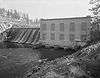 |
(#90001861) |
Charles Rd. at Spokane R. 47°46′32″N 117°32′40″W / 47.775556°N 117.544444°W |
Nine Mile Falls | |
| 16 | Opportunity Township Hall | 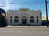 |
(#05000190) |
12114 E. Sprague Ave. 47°39′26″N 117°14′27″W / 47.657222°N 117.240833°W |
Spokane Valley | |
| 17 | Roosevelt Hall | Upload image | (#97001084) |
Eastern Washington Hospital 47°34′18″N 117°41′46″W / 47.571667°N 117.696111°W |
Medical Lake | |
| 18 | Sutton Barn | 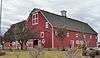 |
(#75001871) |
0.5 mi. SW of Cheney off U.S. 395 47°29′09″N 117°35′18″W / 47.485933°N 117.588401°W |
Cheney | |
| 19 | Turnbull Pines Rock Shelter | Upload image | (#75001872) |
Address Restricted |
Cheney | |
| 20 | Upper Kepple Rockshelters (45SP7) | Upload image | (#85001640) |
Address Restricted |
Cheney | |
| 21 | Washington State Normal School at Cheney Historic District | 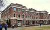 |
(#92001287) |
Jct. of Fifth and C Sts. 47°29′26″N 117°34′47″W / 47.490425°N 117.579720°W |
Cheney | |
| 22 | West Valley High School | Upload image | (#91001736) |
N. 2805 Argonne Rd. 47°40′53″N 117°17′03″W / 47.681389°N 117.284167°W |
Millwood | Rural Public Schools of Washington State MPS. Demolished early 1990s. |
Spokane
| [3] | Name on the Register | Image | Date listed[4] | Location | Description |
|---|---|---|---|---|---|
| 1 | Amman |  |
(#87000086) |
W. 1516 Riverside 47°39′25″N 117°26′01″W / 47.656944°N 117.433611°W |
Built in 1904. |
| 2 | Louise Chandler Anderson House |  |
(#13001030) |
3003 S. Manito Blvd. 47°37′37″N 117°24′25″W / 47.627058°N 117.406983°W |
|
| 3 | Alonzo and Louise Barnett House |  |
(#03000809) |
902 E. Augusta Ave. 47°40′27″N 117°25′28″W / 47.674167°N 117.424444°W |
Built in 1903. |
| 4 | Harvey and Mary Bauer House |  |
(#13001031) |
420 W. 22nd St. 47°38′05″N 117°25′03″W / 47.634732°N 117.417632°W |
|
| 5 | Dr. Robert and Jessie Bell House |  |
(#05000921) |
917 S. Lincoln St. 47°38′57″N 117°25′27″W / 47.649167°N 117.424167°W |
Built in 1908. |
| 6 | Benewah Milk Bottle | 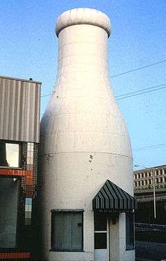 |
(#86001521) |
S. 321 Cedar 47°39′11″N 117°25′53″W / 47.653056°N 117.431389°W |
Built in 1935. |
| 7 | J. W. Binkley House | 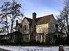 |
(#89000211) |
628 S. Maple 47°39′01″N 117°26′06″W / 47.650278°N 117.435°W |
|
| 8 | Breslin | 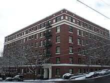 |
(#87000095) |
S. 729 Bernard 47°38′56″N 117°24′54″W / 47.648889°N 117.415°W |
Built in 1910. |
| 9 | Kenneth and Edna Brooks House | 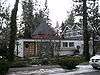 |
(#04001006) |
723 W. Sumner Ave. 47°38′48″N 117°25′15″W / 47.646667°N 117.420833°W |
Built in 1956. |
| 10 | Browne's Addition Historic District |  |
(#76001916) |
Roughly bounded by Sunset Blvd., Maple, Latah Creek, and Spokane River 47°39′19″N 117°26′30″W / 47.655278°N 117.441667°W |
Roughly bounded by Sunset Blvd., Maple, Latah Creek, and Spokane River |
| 11 | Bump Block-Bellevue House-Hawthorne Hotel | 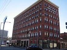 |
(#00000977) |
S 206 Post St. 47°39′16″N 117°25′22″W / 47.654444°N 117.422778°W |
Built in 1890. |
| 12 | Cambern Dutch Shop Windmill | 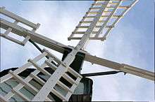 |
(#89000213) |
S. ll02 Perry 47°38′43″N 117°23′20″W / 47.645278°N 117.388889°W |
Built circa 1929. |
| 13 | Campbell House |  |
(#74001979) |
W. 2316 1st Ave. 47°39′25″N 117°26′45″W / 47.656944°N 117.445833°W |
Built in 1898, this house is now part of the Northwest Museum of Arts and Culture. |
| 14 | George and Nellie Canfield House |  |
(#14001109) |
1301 N. Sherwood St. 47°40′08″N 117°27′23″W / 47.6690°N 117.4565°W |
|
| 15 | Central Steam Heat Plant | 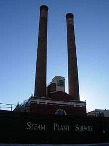 |
(#96001492) |
152 S. Post St. and 815 W. Railroad Ave. 47°39′20″N 117°25′23″W / 47.655556°N 117.423056°W |
Built in 1916. |
| 16 | George and Blanche Christiansen House |  |
(#15000881) |
1329 E. Overbluff Rd. 47°38′09″N 117°23′25″W / 47.635796°N 117.390333°W |
|
| 17 | City Ramp Garage |  |
(#12001099) |
430 W. 1st Ave. 47°39′24″N 117°25′10″W / 47.656716°N 117.419325°W |
|
| 18 | Patsy Clark Mansion |  |
(#75001873) |
W. 2208 2nd Ave. 47°39′19″N 117°26′39″W / 47.655278°N 117.444167°W |
|
| 19 | Clemmer Theater |  |
(#88002758) |
W. 901 Sprague Ave. 47°39′26″N 117°25′26″W / 47.657222°N 117.423889°W |
Built circa 1915; also known as the Bing Crosby Theater |
| 20 | Commercial Block |  |
(#93001103) |
1111-1119 First Ave. W. 47°39′24″N 117°25′39″W / 47.656667°N 117.4275°W |
Built in 1906. |
| 21 | Coolidge-Rising House |  |
(#88000598) |
W. 1405 Ninth Ave. 47°38′50″N 117°25′54″W / 47.647222°N 117.431667°W |
Built circa 1906. |
| 22 | Corbet-Aspray House |  |
(#99001454) |
820 W. 7th Ave. 47°38′59″N 117°25′22″W / 47.649722°N 117.422778°W |
Built in 1908. |
| 23 | Corbin Park Historic District |  |
(#92001584) |
Waverly Pl. (W205-733), Park Pl. (W203-738), W. Oval and E. Oval 47°41′06″N 117°25′03″W / 47.685°N 117.4175°W |
|
| 24 | Daniel C. and Anna Corbin House |  |
(#04000157) |
507 W. Seventh Ave. 47°39′02″N 117°25′11″W / 47.650556°N 117.419722°W |
Built in 1898. |
| 25 | Cowley Park |  |
(#73001891) |
S. Division St. between 6th and 7th Aves. 47°38′58″N 117°24′39″W / 47.649444°N 117.410833°W |
Built in 1917 |
| 26 | The Davenport Hotel | .jpg) |
(#75001874) |
807 W. Sprague 47°39′26″N 117°25′23″W / 47.657222°N 117.423056°W |
Built in 1914. |
| 27 | Desmet Avenue Warehouse Historic District |  |
(#97000450) |
Roughly, N side of Desmet Ave., from Pearl St. to US 395-2 47°40′04″N 117°24′30″W / 47.667778°N 117.408333°W |
|
| 28 | Dodd House |  |
(#10000417) |
603 S. Arthur St. 47°39′03″N 117°23′41″W / 47.650833°N 117.394722°W |
|
| 29 | East Downtown Historic District |  |
(#03000860) |
Roughly bounded by Main Ave., Second Ave., Division St., and Post St. 47°39′24″N 117°25′05″W / 47.656667°N 117.418056°W |
|
| 30 | Gus and Florence Ehrenberg House |  |
(#07000832) |
1304 S. Cook St. 47°38′43″N 117°22′25″W / 47.645278°N 117.373611°W |
Built in 1911. |
| 31 | Eldridge Building |  |
(#92001588) |
1319-1325 W. First Ave. 47°39′24″N 117°25′51″W / 47.656667°N 117.430833°W |
Built circa 1925. |
| 32 | Empire State Building |  |
(#77001361) |
W. 901 Riverside St. 47°39′28″N 117°25′27″W / 47.657778°N 117.424167°W |
Built circa 1900, this is also known as the Great Western Building. |
| 33 | Fairmont Hotel |  |
(#01001204) |
315 W. Riverside Ave., 314 W. Sprague Ave. 47°39′27″N 117°25′00″W / 47.6575°N 117.416667°W |
|
| 34 | Felts Field Historic District | 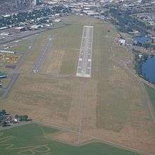 |
(#91001442) |
Roughly, Rutter Ave. between Fancher and Dollar Rds. 47°40′50″N 117°19′15″W / 47.680556°N 117.320833°W |
|
| 35 | Finch House | 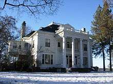 |
(#76001917) |
W. 2340 1st Ave., S. 104 Poplar 47°39′27″N 117°26′48″W / 47.6575°N 117.446667°W |
Built circa 1897, this home was designed by Kirtland Cutter & Karl G. Malmgren of Cutter & Malmgren. |
| 36 | John A. Finch Memorial Nurses Home | 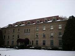 |
(#91000631) |
N. 852 Summit Blvd. 47°39′57″N 117°27′16″W / 47.665833°N 117.454444°W |
Built in 1929. |
| 37 | John A. Finch School | 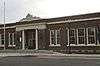 |
(#13001061) |
3717 N. Milton St. 47°41′32″N 117°27′10″W / 47.692213°N 117.452788°W |
|
| 38 | First Congregational Church of Spokane | 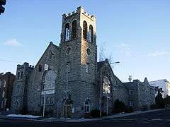 |
(#78002775) |
W. 311-329 4th Ave. 47°39′08″N 117°24′59″W / 47.652222°N 117.416389°W |
Built in 1890. |
| 39 | Five Mile Prairie School |  |
(#04000952) |
8621 N. Five Mile Rd. 47°44′19″N 117°27′16″W / 47.738611°N 117.454444°W |
Built in 1939. Rural Public Schools of Washington State MPS |
| 40 | Fort George Wright Historic District | 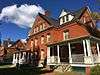 |
(#76001918) |
W. 4000 Randolph Rd. 47°40′42″N 117°28′27″W / 47.678333°N 117.474167°W |
Founded in 1897. |
| 41 | Fox Theater | 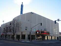 |
(#01001287) |
1005 W. Sprague Ave. 47°39′25″N 117°25′34″W / 47.656944°N 117.426111°W |
Built in 1931, this theater was remodeled and renamed the Martin Woldson Theater at the Fox in 2007. |
| 42 | Frequency Changing Station | 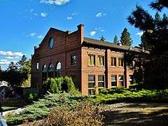 |
(#79002556) |
E. 1420 Celesta Ave. 47°39′06″N 117°23′14″W / 47.651667°N 117.387222°W |
Built in 1908. |
| 43 | W. P. Fuller and Company Warehouse |  |
(#95001529) |
E. 111 and E. 115 Desmet 47°40′03″N 117°24′27″W / 47.6675°N 117.4075°W |
Built circa 1915. |
| 44 | Garland Theater | 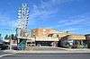 |
(#13000999) |
924 W. Garland Ave. 47°41′38″N 117°25′32″W / 47.693898°N 117.425587°W |
Part of the Movie Theaters in Washington State MPS |
| 45 | Germond Block | 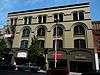 |
(#13001062) |
830 W. Sprague Ave. 47°39′27″N 117°25′29″W / 47.657386°N 117.424723°W |
|
| 46 | The Globe Hotel |  |
(#97001080) |
204 N. Division St. 47°39′34″N 117°24′35″W / 47.659444°N 117.409722°W |
Built in 1908. |
| 47 | Glover House |  |
(#73001892) |
W. 321 8th Ave. 47°38′54″N 117°24′57″W / 47.648333°N 117.415833°W |
Built circa 1888, this home was designed by Kirtland Cutter. |
| 48 | Grace Baptist Church |  |
(#92001289) |
1527 W. Mallon St. 47°39′55″N 117°26′03″W / 47.665278°N 117.434167°W |
Built in 1908. |
| 49 | Hill–Hilscher House | |
(#13001063) |
1638 S. Cedar St. 47°38′22″N 117°25′58″W / 47.639576°N 117.432784°W |
|
| 50 | Hillyard High School |  |
(#05000920) |
5313 N. Regal St. 47°42′23″N 117°22′04″W / 47.706389°N 117.367778°W |
Built in 1912, the building was converted to apartments in the 1940s. |
| 51 | Hillyard Historic Business District |  |
(#02000860) |
N. 4912-5220 Market St., E. 3108-3117 Olympic Ave. 47°42′15″N 117°21′49″W / 47.704167°N 117.363611°W |
|
| 52 | Holley-Mason Building | 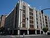 |
(#83004262) |
S. 157 Howard 47°39′19″N 117°25′12″W / 47.655278°N 117.42°W |
Built circa 1905. |
| 53 | Holy Names Academy Building |  |
(#86000959) |
1216 N. Superior St. 47°40′08″N 117°23′28″W / 47.668889°N 117.391111°W |
Built in 1891. |
| 54 | Hotel Upton |  |
(#94000798) |
S. 106 Cedar St. 47°38′52″N 117°25′54″W / 47.647778°N 117.431667°W |
Built in 1910, this is also known as the Grand Coulee Building. |
| 55 | Hutton Building |  |
(#83004037) |
9 S. Washington St. 47°39′25″N 117°25′00″W / 47.656944°N 117.416667°W |
Built circa 1907. |
| 56 | Hutton Settlement |  |
(#76001919) |
9907 Wellesley 47°42′00″N 117°15′53″W / 47.7°N 117.264722°W |
|
| 57 | Levi and May Arkwright Hutton House | 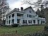 |
(#02000088) |
2206 W. 17th Ave. 47°38′24″N 117°22′40″W / 47.64°N 117.377778°W |
Built in 1914, this was the home of May Arkwright. |
| 58 | Kemp & Hebert Building | 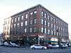 |
(#94000660) |
404 W. Main Ave. 47°39′35″N 117°25′03″W / 47.659722°N 117.4175°W |
Built in 1908. |
| 59 | Kiesow-Gentsch House | 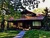 |
(#14001144) |
618 W. 23rd Ave. 47°38′02″N 117°25′17″W / 47.6338°N 117.4215°W |
|
| 60 | Knickerbocker | 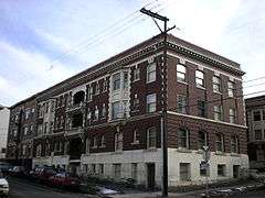 |
(#87000096) |
S. 501-507 Howard 47°39′05″N 117°25′10″W / 47.651389°N 117.419444°W |
Built in 1912. |
| 61 | Knight House |  |
(#99001459) |
1715 N. West Point Rd. 47°40′28″N 117°26′41″W / 47.674444°N 117.444722°W |
Built in 1910. |
| 62 | Koerner House |  |
(#99000915) |
1824 S. Mount Vernon St. 47°38′20″N 117°22′11″W / 47.638889°N 117.369722°W |
Built in 1912. |
| 63 | Levesque-Majer House |  |
(#14001162) |
1708 S. Maple Blvd. 47°38′20″N 117°26′03″W / 47.6389°N 117.4342°W |
|
| 64 | Lewis and Clark High School | 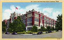 |
(#90001860) |
W. 521 4th Ave. 47°39′08″N 117°25′09″W / 47.652222°N 117.419167°W |
|
| 65 | Littlebrook |  |
(#96000840) |
16704 N. Dartford Dr. 47°48′36″N 117°24′29″W / 47.81°N 117.408056°W |
Built in 1905. |
| 66 | Manito Park and Boulevard |  |
(#15000909) |
1702 S. Grand Blvd. 47°38′07″N 117°24′30″W / 47.635316°N 117.408342°W |
|
| 67 | Marycliff-Cliff Park Historic District |  |
(#79002557) |
Roughly bounded by Lincoln St., 7th, 12th, and 14th Aves. 47°38′46″N 117°25′06″W / 47.646111°N 117.418333°W |
|
| 68 | Gustav Meese Building |  |
(#96000049) |
1727 Sinto Ave. 47°40′11″N 117°26′13″W / 47.669722°N 117.436944°W |
|
| 69 | Miller Block |  |
(#98000370) |
808 W. Sprague Ave. 47°39′28″N 117°25′22″W / 47.657778°N 117.422778°W |
Built circa 1890. |
| 70 | Mission Avenue Historic District |  |
(#86002644) |
E. 220-824 Mission Ave. 47°40′19″N 117°24′04″W / 47.671944°N 117.401111°W |
|
| 71 | Monroe Street Bridge |  |
(#76001920) |
Monroe St. between Ide Ave. and Riverfalls Blvd. 47°39′40″N 117°25′32″W / 47.661111°N 117.425556°W |
Built in 1911, this bridge had the longest concrete span in the US when it was built. Historic Bridges and Tunnels in Washington TR |
| 72 | Montvale Block |  |
(#98000369) |
1001-1009 W. First Ave. 47°39′24″N 117°25′31″W / 47.656667°N 117.425278°W |
Built in 1899 and also known as the Montvale Hotel, the building was renovated and reopened in 2005, after 25 years of vacancy. |
| 73 | Mount Saint Michael | 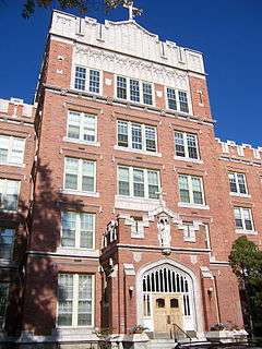 |
(#00000456) |
8500 N. Saint Michael Rd. 47°43′55″N 117°20′21″W / 47.731944°N 117.339167°W |
Built in 1916. |
| 74 | Muzzy-Shine House |  |
(#10001045) |
1506 W. Mission Ave. 47°40′18″N 117°24′51″W / 47.671667°N 117.414167°W |
|
| 75 | Natatorium Carousel | 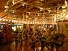 |
(#77001362) |
Spokane Falls Blvd. 47°39′39″N 117°25′10″W / 47.660833°N 117.419444°W |
Built circa 1909 and also known as the Natatorium Carousel, this carousel was designed by Charles I. D. Looff and moved from Natatorium Park to its current site at Riverfront Park in 1975. |
| 76 | Nettleton's Addition Historic District |  |
(#06000176) |
Area bounded by W. Summit, Mission, N Summit, A St. Bridge, and Chestnut 47°40′08″N 117°26′34″W / 47.668889°N 117.442778°W |
Established in 1887. |
| 77 | Ninth Avenue Historic District |  |
(#94000679) |
Roughly bounded by 7th Ave., Monroe St., 12th Ave. and the Burlington Northern RR tracks 47°38′51″N 117°26′02″W / 47.6475°N 117.433889°W |
|
| 78 | Otis Hotel | 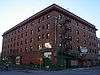 |
(#98001227) |
1101-1109 W. First 47°39′24″N 117°25′38″W / 47.656667°N 117.427222°W |
Built in 1911. |
| 79 | Eben and Cynthia Palmer Farmstead | Upload image | (#14001163) |
6616 E. Orchard Rd. 47°44′18″N 117°18′55″W / 47.7383°N 117.3152°W |
|
| 80 | Peaceful Valley Historic District | 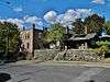 |
(#84003617) |
Roughly bounded by the Spokane River, Wilson Ave., Elm, and Cedar Sts. 47°39′32″N 117°26′03″W / 47.658889°N 117.434167°W |
|
| 81 | Peyton Building and Peyton Annex | 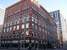 |
(#05000191) |
722 W. Sprague Ave./10 N. Post St. 47°39′34″N 117°25′24″W / 47.659444°N 117.423333°W |
Built in 1898 and 1908. |
| 82 | Victor & Jean Piollet House |  |
(#10001019) |
606 W. 16th Ave. 47°38′28″N 117°25′15″W / 47.641111°N 117.420833°W |
|
| 83 | John and Mary Ralston House |  |
(#02001488) |
2421 W. Mission Ave. 47°40′17″N 117°26′53″W / 47.671389°N 117.448056°W |
Built in 1900. |
| 84 | Review Building | 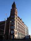 |
(#75001875) |
SE corner, Riverside Ave. and Monroe St. 47°39′28″N 117°25′31″W / 47.657778°N 117.425278°W |
Built in 1890. |
| 85 | Royal Riblet House | Upload image | (#79002558) |
East of Spokane on Fruit Hill Rd. 47°41′52″N 117°14′57″W / 47.697778°N 117.249167°W |
Built in 1925. |
| 86 | Richardson-Jackson House |  |
(#06000178) |
1226 N. Summit Blvd. 47°40′13″N 117°27′29″W / 47.670278°N 117.458056°W |
Built in 1906. |
| 87 | Ridpath Hotel |  |
(#13001000) |
515 W. Sprague Ave. 47°39′25″N 117°25′13″W / 47.656861°N 117.420388°W |
|
| 88 | Riverside Avenue Historic District |  |
(#76001921) |
Riverside Ave. 47°39′27″N 117°25′44″W / 47.6575°N 117.428889°W |
|
| 89 | Robinwood Apartments |  |
(#05000248) |
209-223 West Ninth Ave. 47°38′57″N 117°24′54″W / 47.649167°N 117.415°W |
Built in 1939. |
| 90 | Rockwood Historic District |  |
(#97000320) |
Roughly, Rockwood Blvd. from 11th to 29th Aves. 47°38′12″N 117°23′56″W / 47.636667°N 117.398889°W |
|
| 91 | John R. Rogers High School | 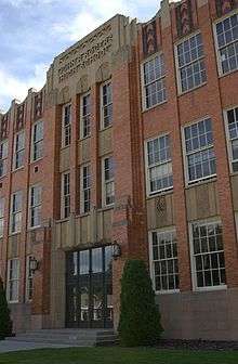 |
(#10001104) |
1622 E. Wellesley Ave. 47°47′58″N 117°23′09″W / 47.799444°N 117.385833°W |
|
| 92 | Roosevelt Apartments | 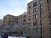 |
(#00000969) |
524 W. Seventh Ave. 47°38′59″N 117°24′59″W / 47.649722°N 117.416389°W |
Built in 1929. |
| 93 | Rosebush House | 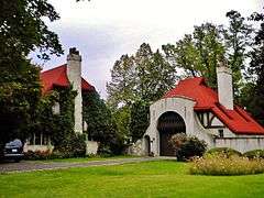 |
(#00001446) |
3318 N. Marguerite Rd. 47°41′15″N 117°17′02″W / 47.6875°N 117.283889°W |
|
| 94 | Salvation Army Building | 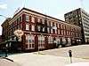 |
(#00001445) |
245 W. Main Ave. 47°39′32″N 117°24′53″W / 47.658889°N 117.414722°W |
Built in 1921. |
| 95 | San Marco |  |
(#87000090) |
W. 1229 Riverside 47°39′27″N 117°25′48″W / 47.6575°N 117.43°W |
Built in 1904. |
| 96 | Schade Brewery |  |
(#94001441) |
E. 528 Trent Ave. 47°39′40″N 117°24′05″W / 47.661111°N 117.401389°W |
Originally built 1902-03, additional construction was in 1907 and 1934–1937. |
| 97 | Sears, Roebuck Department Store |  |
(#91000629) |
W. 902 Main Ave. 47°39′34″N 117°25′28″W / 47.659444°N 117.424444°W |
Built in 1929 and also known as the Comstock Library, this art deco building was demolished in 1992. |
| 98 | Seehorn-Lang Building |  |
(#97001674) |
151-165 S. Lincoln St. 47°39′20″N 117°25′25″W / 47.655556°N 117.423611°W |
|
| 99 | William O. and Stella M. Seligman House |  |
(#14001054) |
2203 S. Manito Blvd. 47°38′03″N 117°24′27″W / 47.6343°N 117.4074°W |
|
| 100 | Edwin A. Smith House |  |
(#85001808) |
N. 1414 Summit Blvd. 47°40′14″N 117°27′19″W / 47.670556°N 117.455278°W |
Built circa 1912. |
| 101 | William and Margaret Solby House |  |
(#07000831) |
1325 E. 20th Ave. 47°38′20″N 117°23′25″W / 47.638889°N 117.390278°W |
Built in 1926. |
| 102 | Spokane City Hall Building |  |
(#85000350) |
N. 221 Wall St. and W. 711 Spokane Falls Blvd. 47°39′35″N 117°25′18″W / 47.659722°N 117.421667°W |
Built 1912-13, this was planned to be a "temporary" city hall, but functioned in this capacity for 70 years. |
| 103 | Spokane Club Building-Legion Building |  |
(#94000800) |
108 N. Washington St. 47°39′30″N 117°25′00″W / 47.658333°N 117.416667°W |
Built in 1910 and designed by Kirtland Cutter. |
| 104 | Spokane County Courthouse | 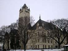 |
(#74001980) |
W. 1116 Broadway 47°39′54″N 117°25′40″W / 47.665°N 117.427778°W |
Built 1894-95 and designed by Willis Ritchie. |
| 105 | Spokane Fire Station No. 3 | 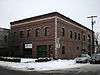 |
(#94001439) |
1229 N. Monroe St. 47°40′09″N 117°25′33″W / 47.669167°N 117.425833°W |
|
| 106 | Spokane Flour Mill | 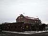 |
(#78002778) |
W. 621 Mallon Ave. 47°39′45″N 117°25′13″W / 47.6625°N 117.420278°W |
Built in 1895, but did not begin operation until 1900 due to legal issues. |
| 107 | Spokane & Inland Empire Railroad Car Facility | 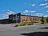 |
(#10000749) |
800 E. Spokane Falls Blvd. 47°39′42″N 117°23′52″W / 47.661667°N 117.397778°W |
|
| 108 | Spokane Public Library |  |
(#82004292) |
925 W. Montgomery St. 47°40′42″N 117°25′31″W / 47.678333°N 117.425278°W |
Carnegie Libraries of Washington TR |
| 109 | Spokane Public Library |  |
(#82004291) |
525 Mission St. 47°40′20″N 117°24′02″W / 47.672222°N 117.400556°W |
Built circa 1913. Carnegie Libraries of Washington TR |
| 110 | Spokane Public Library |  |
(#82004290) |
25 Altamont St. 47°39′24″N 117°22′26″W / 47.656667°N 117.373889°W |
Carnegie Libraries of Washington TR |
| 111 | Spokane Public Library |  |
(#82004910) |
10 S. Cedar 47°39′25″N 117°25′54″W / 47.656944°N 117.431667°W |
Carnegie Libraries of Washington TR |
| 112 | Spokane Sash and Door Company Flats |  |
(#05000924) |
1302-1312 W Broadway Ave. 47°40′00″N 117°25′52″W / 47.666667°N 117.431111°W |
Built in 1909 and designed by Kirtland Cutter. |
| 113 | Sunset Boulevard Bridge |  |
(#82004293) |
Spans Latah Creek 47°39′00″N 117°26′48″W / 47.65°N 117.446667°W |
Built 1911-14. Historic Bridges and Tunnels in Washington TR |
| 114 | Dr. Charles and Elsie Thomas House |  |
(#07000834) |
1212 N. Summit Blvd. 47°40′12″N 117°27′28″W / 47.67°N 117.457778°W |
Built in 1907. |
| 115 | Frank and Maude Tuell House |  |
(#06000702) |
416 W. 22nd Ave. 47°38′12″N 117°25′03″W / 47.636667°N 117.4175°W |
|
| 116 | Luther P. and Jane Marie Turner House | 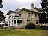 |
(#03001343) |
E. 1521 Illinois Ave 47°40′47″N 117°22′20″W / 47.679722°N 117.372222°W |
Built in 1916. |
| 117 | US Post Office, Courthouse, and Custom House | 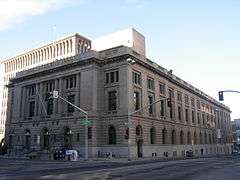 |
(#83004269) |
904 W. Riverside Ave. 47°39′30″N 117°25′31″W / 47.6582°N 117.4254°W |
|
| 118 | Washington Street Bridge | 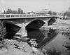 |
(#82004294) |
Spanned Spokane River 47°39′48″N 117°25′01″W / 47.663333°N 117.416944°W |
Built in 1908, this bridge was the oldest of its type in Washington when it was demolished in 1983. |
| 119 | Lawrence and Lydia Weaver House | 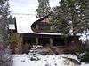 |
(#02000186) |
520 W. 16th Ave. 47°38′29″N 117°25′07″W / 47.641389°N 117.418611°W |
Built in 1910. |
| 120 | West Downtown Historic Transportation Corridor |  |
(#99001631) |
Roughly bounded 2nd Ave., Maple St., Sprague Ave., and Howard St. 47°39′22″N 117°25′40″W / 47.656111°N 117.427778°W |
|
| 121 | Whitten Block |  |
(#93000362) |
N. 1 Post St. 47°39′28″N 117°25′22″W / 47.657778°N 117.422778°W |
Built 1889-90, it is also known as Hamer's, currently houses the Hotel Lusso. |
| 122 | Ralston and Sarah Wilbur House |  |
(#06000136) |
2525 E. 19th Ave. 47°38′26″N 117°22′18″W / 47.640556°N 117.371667°W |
Built in 1916. |
| 123 | James and Corinne Williams House |  |
(#03001344) |
1225 W. 19th Ave. 47°38′16″N 117°25′44″W / 47.637778°N 117.428889°W |
Built in 1911. |
Former listings
| [3] | Name on the Register | Image | Date listed | Date removed | Location | City or town | Summary |
|---|---|---|---|---|---|---|---|
| 1 | Hyde Building and Annex | Upload image | (#78002776) | Formerly at 611½ Riverside Ave. |
Spokane | Built in 1890, this building was demolished in 1979. | |
| 2 | Strahorn Pines | Upload image | (#74002298) | Formerly at W. 2216 1st Ave. |
Spokane | Built in 1904, and designed by Kirtland Cutter, this home was demolished in 1974.[5] |
See also
| Wikimedia Commons has media related to National Register of Historic Places in Spokane County, Washington. |
- List of National Historic Landmarks in Washington
- National Register of Historic Places listings in Washington state
References
- ↑ The latitude and longitude information provided in this table was derived originally from the National Register Information System, which has been found to be fairly accurate for about 99% of listings. For about 1% of NRIS original coordinates, experience has shown that one or both coordinates are typos or otherwise extremely far off; some corrections may have been made. A more subtle problem causes many locations to be off by up to 150 yards, depending on location in the country: most NRIS coordinates were derived from tracing out latitude and longitudes off of USGS topographical quadrant maps created under the North American Datum of 1927, which differs from the current, highly accurate WGS84 GPS system used by most on-line maps. Chicago is about right, but NRIS longitudes in Washington are higher by about 4.5 seconds, and are lower by about 2.0 seconds in Maine. Latitudes differ by about 1.0 second in Florida. Some locations in this table may have been corrected to current GPS standards.
- ↑ "National Register of Historic Places: Weekly List Actions". National Park Service, United States Department of the Interior. Retrieved on November 25, 2016.
- 1 2 3 Numbers represent an ordering by significant words. Various colorings, defined here, differentiate National Historic Landmarks and historic districts from other NRHP buildings, structures, sites or objects.
- 1 2 The eight-digit number below each date is the number assigned to each location in the National Register Information System database, which can be viewed by clicking the number.
- ↑

| Topics | |
|---|---|
| Lists by states |
|
| Lists by insular areas | |
| Lists by associated states | |
| Other areas | |
| |
The Lilac City | |
| About | |
| Government | |
| Landmarks and culture | |
| Colleges and universities | |
| Sports events and franchises | |
Municipalities and communities of Spokane County, Washington, United States | ||
|---|---|---|
| Cities | | |
| Towns | ||
| CDPs | ||
| Unincorporated communities | ||
| Ghost towns | ||
This article is issued from Wikipedia - version of the 12/2/2016. The text is available under the Creative Commons Attribution/Share Alike but additional terms may apply for the media files.