National Register of Historic Places listings in Skagit County, Washington
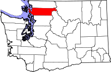
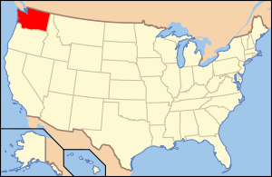
Location of Skagit County in Washington
This is a list of the National Register of Historic Places listings in Skagit County, Washington.
This is intended to be a complete list of the properties and districts on the National Register of Historic Places in Skagit County, Washington, United States. Latitude and longitude coordinates are provided for many National Register properties and districts; these locations may be seen together in a map.[1]
There are 28 properties and districts listed on the National Register in the county. Another property was once listed but has been removed.
- This National Park Service list is complete through NPS recent listings posted December 2, 2016.[2]
Current listings
| [3] | Name on the Register[4] | Image | Date listed[5] | Location | City or town | Description |
|---|---|---|---|---|---|---|
| 1 | Anacortes Public Library | _03.jpg) |
(#77001357) |
1305 8th St. 48°30′56″N 122°36′59″W / 48.515556°N 122.616389°W |
Anacortes | Carnegie Libraries of Washington TR (AD) |
| 2 | Backus-Marblemount Ranger Station House No. 1009 | 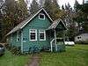 |
(#88003462) |
Ranger Station Rd., 1 mi. N of WA 20 48°32′25″N 121°26′56″W / 48.540278°N 121.448889°W |
Marblemount | |
| 3 | Backus-Marblemount Ranger Station House No. 1010 |  |
(#88003463) |
Ranger Station Rd., 1 mi. N of WA 20 48°32′28″N 121°26′51″W / 48.541111°N 121.4475°W |
Marblemount | |
| 4 | Baker River Bridge | 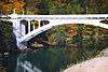 |
(#76001906) |
On WA 17A, over Baker River 48°32′28″N 121°44′34″W / 48.541111°N 121.742778°W |
Concrete | Historic Bridges and Tunnels in Washington TR |
| 5 | Bethsaida Swedish Evangelical Lutheran Church Parsonage |  |
(#90001863) |
1754 Chilberg Rd., Pleasant Ridge 48°23′29″N 122°26′32″W / 48.391389°N 122.442222°W |
La Conner | |
| 6 | Burlington Carnegie Library | 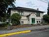 |
(#82004286) |
901 Fairhaven St. 48°28′33″N 122°19′18″W / 48.475833°N 122.321667°W |
Burlington | Carnegie Libraries of Washington TR |
| 7 | California Fruit Store |  |
(#87001949) |
909 Third St. 48°31′13″N 122°36′37″W / 48.520278°N 122.610278°W |
Anacortes | |
| 8 | Causland Park | 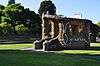 |
(#81000589) |
8th St. and M Ave. 48°30′59″N 122°36′55″W / 48.516389°N 122.615278°W |
Anacortes | |
| 9 | Deception Pass | 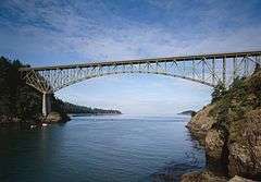 |
(#82004285) |
Rte. 20 48°24′31″N 122°38′37″W / 48.408611°N 122.643611°W |
Anacortes | Historic Bridges and Tunnels in Washington TR, also extends into Island County |
| 10 | Gilbert's Cabin | 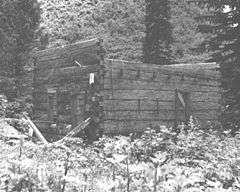 |
(#88003453) |
Cascade River Rd. W of Gilbert Creek 48°29′19″N 121°05′20″W / 48.488611°N 121.088889°W |
Stehekin | |
| 11 | Great Northern Depot | 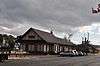 |
(#87001935) |
R Ave. & Seventh St. 48°31′02″N 122°36′28″W / 48.517222°N 122.607778°W |
Anacortes | |
| 12 | Hidden Lake Peak Lookout | 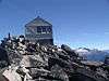 |
(#87001184) |
Mt. Baker Ranger District, Southernmost peak of Hidden Lake Peaks near North Cascades National Park boundary 48°29′44″N 121°12′15″W / 48.495556°N 121.204167°W |
Marblemount | |
| 13 | La Conner Historic District | 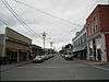 |
(#74001977) |
Roughly bounded by 2nd, Morris and Commercial Sts., and Snohomish Channel 48°23′25″N 122°29′46″W / 48.390278°N 122.496111°W |
La Conner | |
| 14 | LA MERCED | 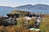 |
(#90000588) |
Anacortes Waterfront off Oakes Ave. 48°30′42″N 122°38′45″W / 48.511667°N 122.645833°W |
Anacortes | A schooner built in 1917; only its hull survives, as a breakwater for Lovric's boatyard on the north coast of Anacortes. |
| 15 | Lincoln Theater and Commercial Block |  |
(#87001987) |
301-329 Kincaid St. & 710-740 First St. 48°25′04″N 122°20′14″W / 48.417778°N 122.337222°W |
Mount Vernon | |
| 16 | Lower Baker River Hydroelectric Power Plant | 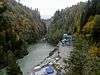 |
(#88002736) |
Baker River at S end of Shannan Lake 48°32′53″N 121°44′24″W / 48.548056°N 121.74°W |
Concrete | |
| 17 | Marine Supply and Hardware Complex | 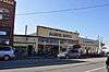 |
(#87001943) |
202-218 Commercial Ave. & 1009 Second St. 48°31′14″N 122°36′42″W / 48.520556°N 122.611667°W |
Anacortes | |
| 18 | Birdsey D. Minkler House | 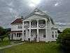 |
(#88002745) |
201 S. Main St. 48°31′31″N 122°03′30″W / 48.525278°N 122.058333°W |
Lyman | |
| 19 | Northern State Hospital | 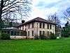 |
(#10001043) |
Roughly bounded by Thompson Dr. to the south, Hemlick Dr. to the east, Hub Dr. to the west, and 1/4 mile south of Mosier Rd. to the north. 48°31′50″N 122°12′24″W / 48.530564°N 122.206581°W |
Sedro-Woolley | |
| 20 | President Hotel |  |
(#10001021) |
310 Myrtle St. 48°25′07″N 122°20′17″W / 48.418611°N 122.338056°W |
Mount Vernon | |
| 21 | Rock Cabin |  |
(#88003457) |
Fisher Creek Trail S of Diablo Lake 48°34′42″N 120°59′47″W / 48.578333°N 120.996389°W |
Diablo | |
| 22 | Semar Block | 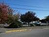 |
(#87001967) |
501 Q Ave. 48°31′07″N 122°36′33″W / 48.518611°N 122.609167°W |
Anacortes | Demolished in 1999, now a parking lot. |
| 23 | Skagit City School | 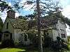 |
(#77001358) |
3.5 mi. S of Mount Vernon on Moore Rd. 48°22′12″N 122°21′59″W / 48.37°N 122.366389°W |
Mount Vernon | |
| 24 | Swamp-Meadow Cabin East | 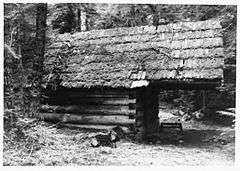 |
(#88003456) |
Thunder Creek Trail S of Diablo Lake 48°34′44″N 121°01′05″W / 48.578889°N 121.018056°W |
Diablo | |
| 25 | Swamp-Meadow Cabin West |  |
(#88003455) |
Thunder Creek Trail S of Diablo Lake 48°34′44″N 121°01′05″W / 48.578889°N 121.018056°W |
Diablo | |
| 26 | US Post Office-Sedro Woolley Main | 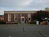 |
(#91000655) |
111 Woodworth St. 48°30′16″N 122°14′18″W / 48.504444°N 122.238333°W |
Sedro-Woolley | |
| 27 | W. T. PRESTON (snagboat) | 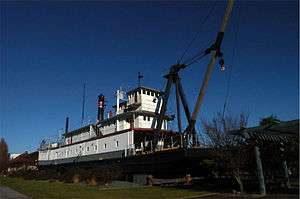 |
(#72001270) |
Anacortes waterfront, R Ave., at foot of 7th St. 48°30′59″N 122°36′29″W / 48.516389°N 122.608056°W |
Anacortes | |
| 28 | Wilson Hotel | 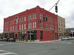 |
(#04001369) |
804 Commercial Ave. 48°31′03″N 122°36′47″W / 48.5175°N 122.613056°W |
Anacortes | The hotel was designed by Pickles and Sutton of Tacoma, built of bricks from See's Brickyard of Anacortes. The style is Romanesque with masticated stone bases, rounded windows and roman arches. The hotel was added to in 1927. Recently, the Wilson underwent complete restoration & earthquake retrofitting. The work was completed in 2007. The Wilson currently features retail on the main floor and low income housing on the upper floors. |
Former listings
| [3] | Name on the Register | Image | Date listed | Date removed | Location | City or town | Summary |
|---|---|---|---|---|---|---|---|
| 1 | Curtis Wharf |  |
(#87001941) | Jct. of O Ave. & Second St. |
Anacortes |
See also
- List of National Historic Landmarks in Washington
- National Register of Historic Places listings in Washington state
References
- ↑ The latitude and longitude information provided in this table was derived originally from the National Register Information System, which has been found to be fairly accurate for about 99% of listings. For about 1% of NRIS original coordinates, experience has shown that one or both coordinates are typos or otherwise extremely far off; some corrections may have been made. A more subtle problem causes many locations to be off by up to 150 yards, depending on location in the country: most NRIS coordinates were derived from tracing out latitude and longitudes off of USGS topographical quadrant maps created under the North American Datum of 1927, which differs from the current, highly accurate WGS84 GPS system used by most on-line maps. Chicago is about right, but NRIS longitudes in Washington are higher by about 4.5 seconds, and are lower by about 2.0 seconds in Maine. Latitudes differ by about 1.0 second in Florida. Some locations in this table may have been corrected to current GPS standards.
- ↑ "National Register of Historic Places: Weekly List Actions". National Park Service, United States Department of the Interior. Retrieved on December 2, 2016.
- 1 2 Numbers represent an ordering by significant words. Various colorings, defined here, differentiate National Historic Landmarks and historic districts from other NRHP buildings, structures, sites or objects.
- ↑ National Park Service (2008-04-24). "National Register Information System". National Register of Historic Places. National Park Service.
- ↑ The eight-digit number below each date is the number assigned to each location in the National Register Information System database, which can be viewed by clicking the number.

| Topics | |
|---|---|
| Lists by states |
|
| Lists by insular areas | |
| Lists by associated states | |
| Other areas | |
| |
Municipalities and communities of Skagit County, Washington, United States | ||
|---|---|---|
| Cities | | |
| Towns | ||
| CDPs | ||
| Unincorporated communities | ||
| Indian reservation | ||
| Ghost towns | ||
| Wikimedia Commons has media related to National Register of Historic Places in Skagit County, Washington. |
This article is issued from Wikipedia - version of the 4/30/2016. The text is available under the Creative Commons Attribution/Share Alike but additional terms may apply for the media files.