Stanwood, Washington
| Stanwood, Washington | |
|---|---|
| City | |
|
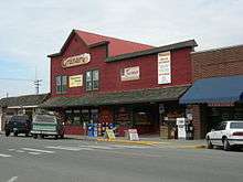
Looking west down Main Street | |
 Location of Stanwood, Washington | |
| Coordinates: 48°14′32″N 122°21′4″W / 48.24222°N 122.35111°WCoordinates: 48°14′32″N 122°21′4″W / 48.24222°N 122.35111°W | |
| Country | United States |
| State | Washington |
| County | Snohomish |
| Area[1] | |
| • Total | 2.84 sq mi (7.36 km2) |
| • Land | 2.82 sq mi (7.30 km2) |
| • Water | 0.02 sq mi (0.05 km2) |
| Elevation | 7 ft (2 m) |
| Population (2010)[2] | |
| • Total | 6,231 |
| • Estimate (2015)[3] | 6,779 |
| • Density | 2,209.6/sq mi (853.1/km2) |
| Time zone | Pacific (PST) (UTC-8) |
| • Summer (DST) | PDT (UTC-7) |
| ZIP code | 98292 |
| Area code | 360 |
| FIPS code | 53-67455 |
| GNIS feature ID | 1512690[4] |
| Website | www.ci.stanwood.wa.us |

Stanwood is a city in Snohomish County, Washington, United States. The population was 6,231 at the 2010 census.[6]
History
Stanwood was first settled in 1866 by Robert Fulton. Stanwood's Post Office was established as Centerville in 1870, and the name was changed to Stanwood in 1877 by D.O. Pearson after his wife's maiden name.[7][8] Stanwood was officially incorporated on October 19, 1903 and grew at the mouth of the Stillaguamish River one mile west of the 1891 Seattle-Montana Great Northern Railway tracks. East Stanwood (along the railroad tracks) was platted in 1906 and incorporated in 1922. The two towns consolidated in 1960.
Historic buildings
Two buildings in Stanwood are on the National Register of Historic Places:
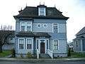 D. O. Pearson House, circa 1890, now part of the Stanwood Area History Museum.
 Stanwood IOOF Public Hall, 1903, now Floyd Norgaard Cultural Center.
Geography
Stanwood is located at 48°14′32″N 122°21′04″W / 48.242276°N 122.351171°W (48.242276, -122.351171).[9]
According to the United States Census Bureau, the city has a total area of 2.84 square miles (7.36 km2), of which, 2.82 square miles (7.30 km2) is land and 0.02 square miles (0.05 km2) is water.[1]
The Gateway Bridge connects Stanwood to Camano Island and provides the only road access to the island.
Police
Stanwood contracts with the Snohomish County Sheriff's Office for police services. Deputies assigned to Stanwood drive patrol cars marked with the city logo. There are currently 6 patrol deputies, one school resource officer, one detective, three sergeants, and one chief assigned full-time to the city.
Demographics
| Historical population | |||
|---|---|---|---|
| Census | Pop. | %± | |
| 1910 | 544 | — | |
| 1920 | 704 | 29.4% | |
| 1930 | 715 | 1.6% | |
| 1940 | 600 | −16.1% | |
| 1950 | 710 | 18.3% | |
| 1960 | 646 | −9.0% | |
| 1970 | 1,347 | 108.5% | |
| 1980 | 1,646 | 22.2% | |
| 1990 | 1,961 | 19.1% | |
| 2000 | 3,923 | 100.1% | |
| 2010 | 6,231 | 58.8% | |
| Est. 2015 | 6,779 | [10] | 8.8% |
| U.S. Decennial Census[11] 2015 Estimate[3] | |||
2010 census
As of the census[2] of 2010, there were 6,231 people, 2,388 households, and 1,541 families residing in the city. The population density was 2,209.6 inhabitants per square mile (853.1/km2). There were 2,584 housing units at an average density of 916.3 per square mile (353.8/km2). The racial makeup of the city was 89.7% White, 1.0% African American, 0.8% Native American, 1.7% Asian, 0.3% Pacific Islander, 2.6% from other races, and 3.9% from two or more races. Hispanic or Latino of any race were 7.0% of the population.
There were 2,388 households of which 38.0% had children under the age of 18 living with them, 47.7% were married couples living together, 12.1% had a female householder with no husband present, 4.7% had a male householder with no wife present, and 35.5% were non-families. 29.6% of all households were made up of individuals and 16.2% had someone living alone who was 65 years of age or older. The average household size was 2.55 and the average family size was 3.18.
The median age in the city was 35.9 years. 28.1% of residents were under the age of 18; 8% were between the ages of 18 and 24; 27.2% were from 25 to 44; 21.3% were from 45 to 64; and 15.3% were 65 years of age or older. The gender makeup of the city was 47.3% male and 52.7% female.
2000 census
As of the census of 2000, there were 3,923 people, 1,402 households, and 957 families residing in the city. The population density was 1,995.4 people per square mile (768.9/km2). There were 1,508 housing units at an average density of 767.0 per square mile (295.6/km2). The racial makeup of the city was 91.56% White, 0.59% African American, 0.94% Native American, 1.10% Asian, 0.23% Pacific Islander, 2.52% from other races, and 3.06% from two or more races. Hispanic or Latino of any race were 4.97% of the population.
There were 1,402 households out of which 42.3% had children under the age of 18 living with them, 51.3% were married couples living together, 12.3% had a female householder with no husband present, and 31.7% were non-families. 26.7% of all households were made up of individuals and 13.8% had someone living alone who was 65 years of age or older. The average household size was 2.65 and the average family size was 3.22.
In the city the age distribution of the population shows 31.5% under the age of 18, 6.6% from 18 to 24, 30.6% from 25 to 44, 14.5% from 45 to 64, and 16.9% who were 65 years of age or older. The median age was 34 years. For every 100 females there were 89.9 males. For every 100 females age 18 and over, there were 81.2 males.
The median income for a household in the city was $44,512, and the median income for a family was $52,996. Males had a median income of $40,457 versus $26,738 for females. The per capita income for the city was $16,775. About 9.0% of families and 12.0% of the population were below the poverty line, including 8.9% of those under age 18 and 23.4% of those age 65 or over.
Transportation
Amtrak's Cascades provides daily passenger rail service to Stanwood at a new station which opened on November 21, 2009.
Education
Stanwood has one high school, two middle schools, and three elementary schools in town with two others on Camano Island, one alternative high school, and one alternative middle school for 7th and 8th graders. Stanwood High School has about 1,800 students and 87 teachers, and is still growing. A bond was made in May 2006 for a new high school that would help relieve the growing population, but was turned down. When the school was built in 1971, it was originally made to hold 800 students. It was originally built as a "California-style" high school, where there were no hallways, and everything was accessed from outside. Since then, additions have been made in 1980, 1993, and 2001.
High schools
- Lincoln Hill High School (alternative school)
- Stanwood High School
Middle schools
Elementary schools
- Cedarhome Elementary School
- Elger Bay Elementary School (Camano Island)
- Stanwood Elementary School
- Twin City Elementary School
- Utsalady Elementary School (Camano Island)
- Saratoga School (K-12)
Notable people
- T. J. Oshie, center for the Washington Capitals,[12] and USA Olympian
References
- 1 2 "US Gazetteer files 2010". United States Census Bureau. Retrieved 2012-12-19.
- 1 2 "American FactFinder". United States Census Bureau. Retrieved 2012-12-19.
- 1 2 "Population Estimates". United States Census Bureau. Retrieved June 25, 2016.
- ↑ "US Board on Geographic Names". United States Geological Survey. 2007-10-25. Retrieved 2008-01-31.
- ↑ Prasse, Karen. River, Rail, & Road A Pictorial History of Stanwood & East Stanwood, Washington. Stanwood, Wash: Stanwood Area Historical Society, 2003.
- ↑ "2010 City Population and Housing Occupancy Status". U.S. Census Bureau. Retrieved December 9, 2012.
- ↑ Majors, Harry M. (1975). Exploring Washington. Van Winkle Publishing Co. p. 18. ISBN 978-0-918664-00-6.
- ↑ Meany, Edmond S. (1923). Origin of Washington geographic names. Seattle: University of Washington Press. p. 287.
- ↑ "US Gazetteer files: 2010, 2000, and 1990". United States Census Bureau. 2011-02-12. Retrieved 2011-04-23.
- ↑ "Annual Estimates of the Resident Population for Incorporated Places: April 1, 2010 to July 1, 2015". Retrieved July 2, 2016.
- ↑ United States Census Bureau. "Census of Population and Housing". Retrieved July 26, 2013.
- ↑ http://www.nhl.com/ice/trades.htm
External links
- Stanwood Library
- Stanwood Camano News
- Stanwood Area Historical Society
- City of Stanwood Official Website
| Wikimedia Commons has media related to Stanwood, Washington. |
Municipalities and communities of Snohomish County, Washington, United States | ||
|---|---|---|
| Cities | 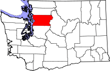 | |
| Towns | ||
| CDPs |
| |
| Other unincorporated communities | ||
| Ghost town | ||
| Indian reservation | ||
| Footnotes | ‡This populated place also has portions in an adjacent county or counties | |