| [3] |
Name on the Register[4] |
Image |
Date listed[5] |
Location |
City or town |
Description |
|---|
| 1 |
Archeological Site 3PP141 |
Upload image |
000000002006-11-08-0000November 8, 2006
(#06000837) |
Address Restricted
|
Atkins |
|
| 2 |
Archeological Site 3PP142 |
Upload image |
000000002006-11-08-0000November 8, 2006
(#06000839) |
Address Restricted
|
Atkins |
|
| 3 |
Archeological Site 3PP614 |
Upload image |
000000002007-05-23-0000May 23, 2007
(#07000203) |
Address Restricted
|
Sand Gap |
|
| 4 |
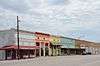
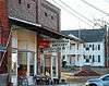
Atkins Commercial Historic District |
|
000000002009-09-18-0000September 18, 2009
(#09000739) |
Roughly bounded by Main, Church, and 1st Sts., Ave. 2.
35°14′33″N 92°56′18″W / 35.242544°N 92.938306°W / 35.242544; -92.938306 (Atkins Commercial Historic District) |
Atkins |
|
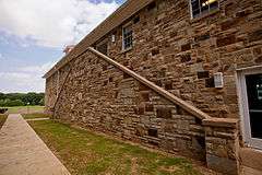
| 5 |
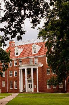
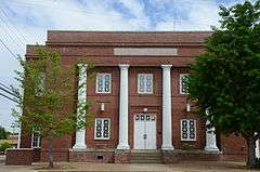
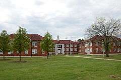
Caraway Hall-Arkansas Tech University |
|
000000001992-09-10-0000September 10, 1992
(#92001213) |
N. Arkansas St.
35°17′33″N 93°08′02″W / 35.2925°N 93.133889°W / 35.2925; -93.133889 (Caraway Hall-Arkansas Tech University) |
Russellville |
|
| 6 |
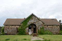
Center Valley Well House |
|
000000001992-09-10-0000September 10, 1992
(#92001206) |
Highway 124
35°19′47″N 93°05′09″W / 35.329722°N 93.085833°W / 35.329722; -93.085833 (Center Valley Well House) |
Center Valley |
|
| 7 |
Confederate Mothers Memorial Park |
|
000000001996-05-03-0000May 3, 1996
(#96000500) |
Junction of Highway 326 and S. Glenwood Ave.
35°15′30″N 93°08′26″W / 35.258333°N 93.140556°W / 35.258333; -93.140556 (Confederate Mothers Memorial Park) |
Russellville |
|
| 8 |
Crow Mountain Petroglyph |
Upload image |
000000001982-05-04-0000May 4, 1982
(#82004838) |
Address Restricted
|
Dover |
|
| 9 |
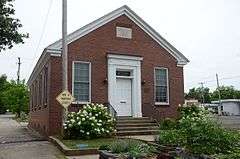
Fair View School |
|
000000002000-02-04-0000February 4, 2000
(#00000030) |
2367 Mill Creek Rd.
35°21′13″N 93°12′41″W / 35.353611°N 93.211389°W / 35.353611; -93.211389 (Fair View School) |
Russellville |
|
| 10 |
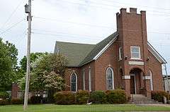
First Christian Church |
|
000000002006-05-24-0000May 24, 2006
(#06000418) |
103 S. Boston Ave.
35°16′47″N 93°07′55″W / 35.279722°N 93.131944°W / 35.279722; -93.131944 (First Christian Church) |
Russellville |
|
| 11 |
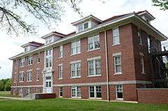
Girls' Domestic Science and Arts Building-Arkansas Tech University |
|
000000001992-09-18-0000September 18, 1992
(#92001212) |
East of N. El Paso St.
35°17′33″N 93°08′04″W / 35.2925°N 93.134444°W / 35.2925; -93.134444 (Girls' Domestic Science and Arts Building-Arkansas Tech University) |
Russellville |
|
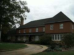
| 12 |
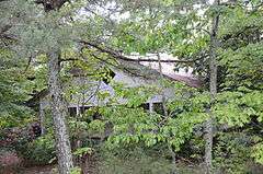
Thomas J. Hankins House |
|
000000002013-09-30-0000September 30, 2013
(#13000788) |
Western side of Highway 7 approximately 375 feet north of its junction with Highway 123
35°43′19″N 93°05′47″W / 35.722071°N 93.09652°W / 35.722071; -93.09652 (Thomas J. Hankins House) |
Pelsor |
|
| 13 |
Hughes Hall-Arkansas Tech University |
|
000000001992-09-18-0000September 18, 1992
(#92001210) |
W. M St.
35°17′32″N 93°08′20″W / 35.292222°N 93.138889°W / 35.292222; -93.138889 (Hughes Hall-Arkansas Tech University) |
Russellville |
|
| 14 |
Henry R. Koen Forest Service Building |
|
000000001989-12-11-0000December 11, 1989
(#89001628) |
605 W. Main St.
35°16′43″N 93°08′20″W / 35.278611°N 93.138889°W / 35.278611; -93.138889 (Henry R. Koen Forest Service Building) |
Russellville |
|
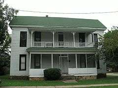
| 15 |
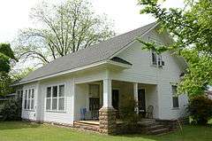
Latimore Tourist Home |
|
000000002012-01-27-0000January 27, 2012
(#11001049) |
318 S. Houston Ave.
35°16′36″N 93°08′26″W / 35.276656°N 93.140483°W / 35.276656; -93.140483 (Latimore Tourist Home) |
Russellville |
part of the Arkansas Highway History and Architecture Multiple Property Submission
|
| 16 |
Little Rock to Cantonment Gibson Rd-Fourth Street Segment |
|
000000002009-01-22-0000January 22, 2009
(#08001342) |
4th St. between Union Grove and Blackland Sts.
35°14′15″N 92°53′56″W / 35.237436°N 92.898761°W / 35.237436; -92.898761 (Little Rock to Cantonment Gibson Rd-Fourth Street Segment) |
Atkins |
A Trail of Tears site[6]
|
| 17 |
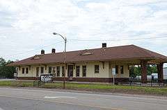
Missouri-Pacific Depot-Atkins |
|
000000001992-06-11-0000June 11, 1992
(#92000600) |
U.S. Route 64
35°14′30″N 92°56′07″W / 35.241667°N 92.935278°W / 35.241667; -92.935278 (Missouri-Pacific Depot-Atkins) |
Atkins |
|
| 18 |
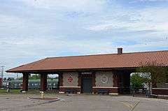
Missouri-Pacific Depot-Russellville |
|
000000001992-06-11-0000June 11, 1992
(#92000620) |
North of the junction of C St. and Denver Ave.
35°16′49″N 93°08′07″W / 35.280278°N 93.135278°W / 35.280278; -93.135278 (Missouri-Pacific Depot-Russellville) |
Russellville |
|
| 19 |
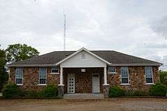
Mountain View School |
|
000000001992-09-10-0000September 10, 1992
(#92001207) |
109 Hilltop Dr. (Highway 326)
35°16′32″N 93°10′14″W / 35.2756°N 93.1706°W / 35.2756; -93.1706 (Mountain View School) |
Russellville |
Now used as a fire station
|
| 20 |
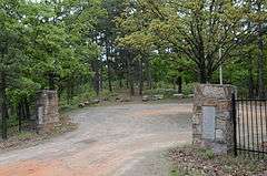
Norristown Cemetery |
|
000000001995-04-14-0000April 14, 1995
(#94001415) |
Off Highway 78 on Lock and Dam Rd.
35°14′35″N 93°09′01″W / 35.243056°N 93.150278°W / 35.243056; -93.150278 (Norristown Cemetery) |
Russellville |
|
| 21 |
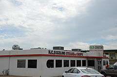
Old South Restaurant |
|
000000001999-09-03-0000September 3, 1999
(#99001064) |
1330 E. Main St.
35°16′41″N 93°07′01″W / 35.278056°N 93.116944°W / 35.278056; -93.116944 (Old South Restaurant) |
Russellville |
|
| 22 |
Physical Education Building-Arkansas Tech University |
|
000000001992-09-10-0000September 10, 1992
(#92001211) |
Southeastern corner of the junction of N. El Paso and W. O Sts.
35°17′36″N 93°08′11″W / 35.293333°N 93.136389°W / 35.293333; -93.136389 (Physical Education Building-Arkansas Tech University) |
Russellville |
|
| 23 |
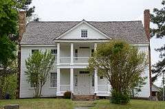
Potts Inn |
|
000000001970-06-22-0000June 22, 1970
(#70000123) |
Main and Center Sts.
35°14′54″N 93°02′42″W / 35.248333°N 93.045°W / 35.248333; -93.045 (Potts Inn) |
Pottsville |
|
| 24 |
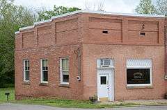
Pottsville Citizen's Bank |
|
000000002002-03-28-0000March 28, 2002
(#02000261) |
156 E. Ash St.
35°14′59″N 93°02′45″W / 35.249722°N 93.045833°W / 35.249722; -93.045833 (Pottsville Citizen's Bank) |
Pottsville |
|
| 25 |
Pottsville Commercial Historic District |
|
000000002005-01-20-0000January 20, 2005
(#04001510) |
155, 160, 162, and 164 E. Ash St.
35°15′07″N 93°02′50″W / 35.251944°N 93.047222°W / 35.251944; -93.047222 (Pottsville Commercial Historic District) |
Pottsville |
|
| 26 |
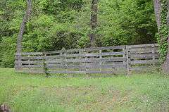
Pottsville Dipping Vat |
|
000000002006-03-02-0000March 2, 2006
(#06000086) |
Corner of Rankin Park on E. Ash St.
35°15′08″N 93°02′48″W / 35.252222°N 93.046667°W / 35.252222; -93.046667 (Pottsville Dipping Vat) |
Pottsville |
|
| 27 |
Riggs-Hamilton American Legion Post No. 20 |
|
000000001994-08-15-0000August 15, 1994
(#94000855) |
215 N. Denver Ave.
35°16′48″N 93°08′09″W / 35.28°N 93.135833°W / 35.28; -93.135833 (Riggs-Hamilton American Legion Post No. 20) |
Russellville |
|
| 28 |
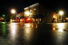
Russellville Downtown Historic District |
|
000000001996-09-03-0000September 3, 1996
(#96000941) |
Roughly bounded by W. 2nd St., Arkansas Ave., the former Missouri Pacific railroad tracks, and El Paso St.
35°16′44″N 93°08′06″W / 35.278889°N 93.135°W / 35.278889; -93.135 (Russellville Downtown Historic District) |
Russellville |
|
| 29 |
Russellville Masonic Temple |
|
000000002005-06-01-0000June 1, 2005
(#05000499) |
205 S. Commerce
35°16′39″N 93°08′07″W / 35.2775°N 93.135278°W / 35.2775; -93.135278 (Russellville Masonic Temple) |
Russellville |
|
| 30 |
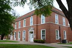
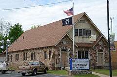
Russellville Public Library |
|
000000002000-11-20-0000November 20, 2000
(#00001319) |
114 E. 3rd St.
35°16′32″N 93°08′00″W / 35.275556°N 93.133333°W / 35.275556; -93.133333 (Russellville Public Library) |
Russellville |
1937 WPA Colonial Revival building, next to the current library.
|
| 31 |
Threlkeld House |
|
000000002000-06-02-0000June 2, 2000
(#00000610) |
1301 N. Boston Ave.
35°17′27″N 93°07′56″W / 35.290833°N 93.132222°W / 35.290833; -93.132222 (Threlkeld House) |
Russellville |
|
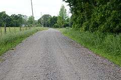
| 32 |
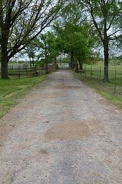
Old US 64, Scotia Segment |
|
000000002007-09-19-0000September 19, 2007
(#07000959) |
South of U.S. Route 64, east of Cedar Ln.
35°19′56″N 93°17′40″W / 35.332197°N 93.294358°W / 35.332197; -93.294358 (Old US 64, Scotia Segment) |
London |
A Trail of Tears site[6]
|
| 33 |
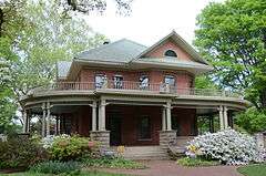
John W. White House |
|
000000001988-05-05-0000May 5, 1988
(#88000524) |
1509 W. Main St.
35°16′55″N 93°08′48″W / 35.281944°N 93.146667°W / 35.281944; -93.146667 (John W. White House) |
Russellville |
|
| 34 |
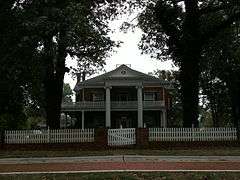
W.J. White House |
|
000000001978-12-13-0000December 13, 1978
(#78000617) |
1412 W. Main St.
35°16′57″N 93°08′54″W / 35.2825°N 93.148333°W / 35.2825; -93.148333 (W.J. White House) |
Russellville |
|
| 35 |
Williamson Hall-Arkansas Tech University |
|
000000001992-09-18-0000September 18, 1992
(#92001208) |
N. El Paso St.
35°17′25″N 93°08′13″W / 35.290278°N 93.136944°W / 35.290278; -93.136944 (Williamson Hall-Arkansas Tech University) |
Russellville |
|
| 36 |
Wilson Hall-Arkansas Tech University |
|
000000001992-09-18-0000September 18, 1992
(#92001209) |
N. El Paso St.
35°17′33″N 93°08′15″W / 35.2925°N 93.1375°W / 35.2925; -93.1375 (Wilson Hall-Arkansas Tech University) |
Russellville |
|
| 37 |
Wilson House |
|
000000001978-03-29-0000March 29, 1978
(#78000618) |
214 E. 5th St.
35°16′25″N 93°07′51″W / 35.273611°N 93.130833°W / 35.273611; -93.130833 (Wilson House) |
Russellville |
|