| [3] |
Name on the Register[4] |
Image |
Date listed[5] |
Location |
City or town |
Description |
|---|
| 1 |
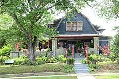
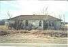
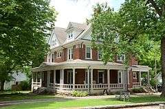
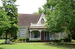
Adler House |
|
000000001982-12-22-0000December 22, 1982
(#82000833) |
292 Boswell St.
35°46′09″N 91°39′02″W / 35.769167°N 91.650556°W / 35.769167; -91.650556 (Adler House) |
Batesville |
|
| 2 |
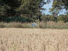
Akron Cemetery |
|
000000002002-10-04-0000October 4, 2002
(#02001072) |
Approximately 2 miles south of Newark on Highway 122
35°39′53″N 91°26′58″W / 35.664722°N 91.449444°W / 35.664722; -91.449444 (Akron Cemetery) |
Newark |
|
| 3 |
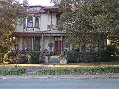
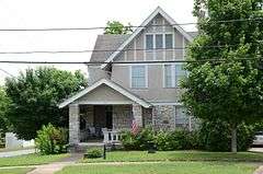
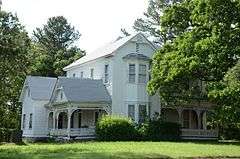
Bartlett-Kirk House |
|
000000001994-08-16-0000August 16, 1994
(#94000856) |
910 College St.
35°46′25″N 91°38′41″W / 35.773611°N 91.644722°W / 35.773611; -91.644722 (Bartlett-Kirk House) |
Batesville |
|
| 4 |
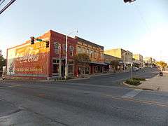
Batesville Commercial Historic District |
|
000000001982-10-07-0000October 7, 1982
(#82000834) |
Main and Central Sts.; also Main St. from north of Central to one block north of Church
35°46′19″N 91°39′14″W / 35.771944°N 91.653889°W / 35.771944; -91.653889 (Batesville Commercial Historic District) |
Batesville |
Second set of boundaries represents a boundary increase of 000000001990-10-05-0000October 5, 1990
|
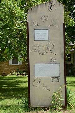
| 5 |
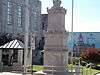
Batesville Confederate Monument |
|
000000001996-05-03-0000May 3, 1996
(#96000504) |
Northeastern corner of the courthouse lawn, at the junction of S. Broad St. and W. Main St.
35°46′13″N 91°39′10″W / 35.770278°N 91.652778°W / 35.770278; -91.652778 (Batesville Confederate Monument) |
Batesville |
|
| 6 |
Batesville East Main Historic District |
|
000000001983-12-22-0000December 22, 1983
(#83003546) |
Main St. between 7th and 11th Sts.; also 1011, 1041, 1063, and 1087 College Ave.
35°46′28″N 91°38′45″W / 35.774444°N 91.645833°W / 35.774444; -91.645833 (Batesville East Main Historic District) |
Batesville |
College Avenue addresses represent a boundary increase of 000000001996-12-27-0000December 27, 1996
|
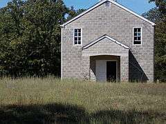
| 7 |
Bethel African Methodist Episcopal Church |
|
000000001986-10-16-0000October 16, 1986
(#86002875) |
895 Oak St.
35°46′20″N 91°38′14″W / 35.772222°N 91.637222°W / 35.772222; -91.637222 (Bethel African Methodist Episcopal Church) |
Batesville |
|
| 8 |
Big Botton Slough Bridge |
|
000000002004-09-24-0000September 24, 2004
(#04001042) |
County Road 58 (Padgett Island Rd.), approximately 2.5 miles south of Highway 69
35°40′19″N 91°28′38″W / 35.671944°N 91.477222°W / 35.671944; -91.477222 (Big Botton Slough Bridge) |
Magness |
|
| 9 |
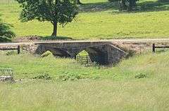
Cedar Creek Bridge |
|
000000001995-05-18-0000May 18, 1995
(#95000613) |
County Road 235 over Cedar Creek, approximately 1.5 miles south of its junction with Highway 14
35°38′34″N 91°32′26″W / 35.642778°N 91.540556°W / 35.642778; -91.540556 (Cedar Creek Bridge) |
Rosie |
|
| 10 |
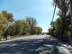
Central Avenue Bridge |
|
000000002010-01-21-0000January 21, 2010
(#09001248) |
Central Avenue over Polk Bayou
35°46′16″N 91°39′19″W / 35.771056°N 91.655158°W / 35.771056; -91.655158 (Central Avenue Bridge) |
Batesville |
|
| 11 |
Cook-Morrow House |
|
000000001977-07-29-0000July 29, 1977
(#77000256) |
875 Main St.
35°46′27″N 91°38′50″W / 35.774167°N 91.647222°W / 35.774167; -91.647222 (Cook-Morrow House) |
Batesville |
|
| 12 |
Dearing House |
|
000000001976-05-03-0000May 3, 1976
(#76000419) |
Highway 122
35°42′09″N 91°26′23″W / 35.7025°N 91.439722°W / 35.7025; -91.439722 (Dearing House) |
Newark |
|
| 13 |
Franklin Desha House |
Upload image |
000000001986-10-09-0000October 9, 1986
(#86002844) |
Address Restricted
|
Desha |
|
| 14 |
Edward Dickinson House |
|
000000001986-11-26-0000November 26, 1986
(#86002907) |
672 E. Boswell St.
35°46′17″N 91°38′48″W / 35.771389°N 91.646667°W / 35.771389; -91.646667 (Edward Dickinson House) |
Batesville |
|
| 15 |
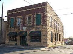
Dondy Building |
|
000000001982-12-22-0000December 22, 1982
(#82000824) |
154 S. 3rd
35°46′14″N 91°39′06″W / 35.770556°N 91.651667°W / 35.770556; -91.651667 (Dondy Building) |
Batesville |
|
| 16 |
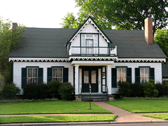
Garrott House |
|
000000001971-06-24-0000June 24, 1971
(#71000125) |
561 E. Main St.
35°46′21″N 91°38′59″W / 35.772628°N 91.649647°W / 35.772628; -91.649647 (Garrott House) |
Batesville |
|
| 17 |
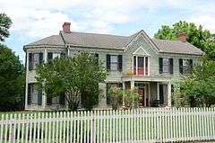
Glenn House |
|
000000001975-05-02-0000May 2, 1975
(#75000389) |
653 Water St.
35°46′26″N 91°38′58″W / 35.773889°N 91.649444°W / 35.773889; -91.649444 (Glenn House) |
Batesville |
|
| 18 |
Goff Petroglyph Site |
Upload image |
000000001982-05-04-0000May 4, 1982
(#82002117) |
Address Restricted
|
Salado |
|
| 19 |
Charles R. Handford House |
|
000000001975-05-02-0000May 2, 1975
(#75000390) |
658 E. Boswell St.
35°46′16″N 91°38′49″W / 35.771111°N 91.646944°W / 35.771111; -91.646944 (Charles R. Handford House) |
Batesville |
|
| 20 |
James S. Handford House |
|
000000001975-05-02-0000May 2, 1975
(#75000391) |
659 E. Boswell St.
35°46′18″N 91°38′50″W / 35.771667°N 91.647222°W / 35.771667; -91.647222 (James S. Handford House) |
Batesville |
|
| 21 |
Hankins' Store |
|
000000002014-05-23-0000May 23, 2014
(#14000248) |
NE. corner of Ferry Rd. & Main St.
35°37′56″N 91°27′47″W / 35.6322°N 91.4630°W / 35.6322; -91.4630 (Hankins' Store) |
Oil Trough |
|
| 22 |
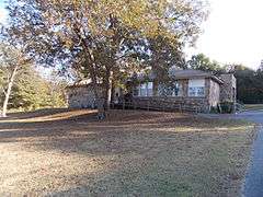
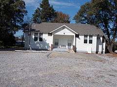
Hulsey Bend School |
|
000000001999-02-12-0000February 12, 1999
(#99000153) |
Freeze Bend Rd., 0.7 miles east of the junction of Highways 14 and 122
35°38′07″N 91°25′05″W / 35.635278°N 91.418056°W / 35.635278; -91.418056 (Hulsey Bend School) |
Oil Trough |
|
| 23 |
Jamestown School |
|
000000001992-09-04-0000September 4, 1992
(#92001106) |
North of Highway 230
35°41′50″N 91°42′13″W / 35.697222°N 91.703611°W / 35.697222; -91.703611 (Jamestown School) |
Jamestown |
|
| 24 |
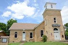
Lee's Chapel Church and Masonic Hall |
|
000000002001-05-10-0000May 10, 2001
(#01000482) |
8 miles east on Sandtown Rd.
35°54′09″N 91°38′32″W / 35.9025°N 91.642222°W / 35.9025; -91.642222 (Lee's Chapel Church and Masonic Hall) |
Cushman |
|
| 25 |
Luster Urban Farmstead |
|
000000001983-09-16-0000September 16, 1983
(#83001158) |
487 N. Central Ave.
35°46′20″N 91°39′24″W / 35.772222°N 91.656667°W / 35.772222; -91.656667 (Luster Urban Farmstead) |
Batesville |
|
| 26 |
Miller Creek Bridge |
|
000000002010-01-21-0000January 21, 2010
(#09001249) |
County Road 86 over Miller Creek
35°47′00″N 91°37′10″W / 35.783231°N 91.619414°W / 35.783231; -91.619414 (Miller Creek Bridge) |
Batesville |
|
| 27 |
Mitchell House |
|
000000001982-12-22-0000December 22, 1982
(#82000835) |
1138 Main St.
35°46′33″N 91°38′36″W / 35.775833°N 91.643333°W / 35.775833; -91.643333 (Mitchell House) |
Batesville |
|
| 28 |
Moorefield School |
|
000000001992-09-04-0000September 4, 1992
(#92001109) |
65 Ham St.
35°45′57″N 91°34′12″W / 35.7658°N 91.5700°W / 35.7658; -91.5700 (Moorefield School) |
Moorefield |
|
| 29 |
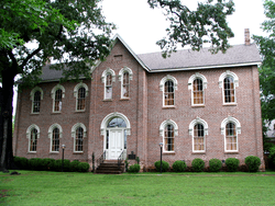
Morrow Hall |
|
000000001972-10-18-0000October 18, 1972
(#72000205) |
7th and Boswell Sts.
35°46′21″N 91°38′35″W / 35.7725°N 91.643056°W / 35.7725; -91.643056 (Morrow Hall) |
Batesville |
|
| 30 |
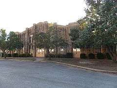
National Guard Armory |
|
000000001998-05-29-0000May 29, 1998
(#98000579) |
380 S. 9th St.
35°46′21″N 91°38′37″W / 35.7725°N 91.643611°W / 35.7725; -91.643611 (National Guard Armory) |
Batesville |
|
| 31 |
Pfeiffer House |
Upload image |
000000001989-05-01-0000May 1, 1989
(#89000172) |
U.S. Route 167
35°49′48″N 91°35′31″W / 35.83°N 91.591944°W / 35.83; -91.591944 (Pfeiffer House) |
Pfeiffer |
|
| 32 |
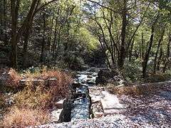
Ruddell Mill Site |
|
000000002007-08-28-0000August 28, 2007
(#07000434) |
Address Restricted
|
Batesville |
|
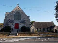
| 33 |
St. Paul's Parish Church |
|
000000001982-12-22-0000December 22, 1982
(#82000836) |
5th and Main
35°46′19″N 91°39′00″W / 35.771944°N 91.65°W / 35.771944; -91.65 (St. Paul's Parish Church) |
Batesville |
|
| 34 |
School Addition Historic District |
|
000000002007-02-01-0000February 1, 2007
(#06001315) |
560-770 Water, 210-293 N. 7th, 709-897 Rock, and 215-280 N. 8th
35°46′28″N 91°38′56″W / 35.774328°N 91.648856°W / 35.774328; -91.648856 (School Addition Historic District) |
Batesville |
|
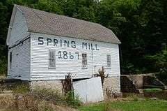
| 35 |
Spring Mill |
|
000000001974-03-01-0000March 1, 1974
(#74000477) |
Northwest of Batesville on Highway 69
35°49′42″N 91°43′24″W / 35.828333°N 91.723333°W / 35.828333; -91.723333 (Spring Mill) |
Batesville |
|
| 36 |
Thida Grove School |
|
000000001992-09-04-0000September 4, 1992
(#92001108) |
County Road 20
35°34′16″N 91°27′58″W / 35.571111°N 91.466111°W / 35.571111; -91.466111 (Thida Grove School) |
Thida |
|
| 37 |
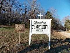
Walnut Grove Cemetery |
|
000000002013-09-30-0000September 30, 2013
(#13000786) |
Walden Rd.
35°50′16″N 91°23′14″W / 35.837746°N 91.387226°W / 35.837746; -91.387226 (Walnut Grove Cemetery) |
Cord |
|
| 37 |
Capt. John T. Warner House |
Upload image |
000000001982-09-02-0000September 2, 1982
(#82002115) |
822 E. College St.
35°46′23″N 91°38′44″W / 35.773056°N 91.645556°W / 35.773056; -91.645556 (Capt. John T. Warner House) |
Batesville |
|
| 39 |
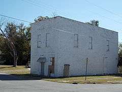
The Wheel Store |
|
000000001988-12-08-0000December 8, 1988
(#88002822) |
River and Broad Sts.
35°46′03″N 91°39′00″W / 35.7675°N 91.65°W / 35.7675; -91.65 (The Wheel Store) |
Batesville |
|
| 40 |
Wyatt House |
|
000000001999-03-05-0000March 5, 1999
(#99000263) |
Junction of Highway 25 and Gainer Ferry Rd.
35°44′13″N 91°40′31″W / 35.736944°N 91.675278°W / 35.736944; -91.675278 (Wyatt House) |
Desha |
|
| 41 |
Wyatt Petroglyphs |
Upload image |
000000001982-05-04-0000May 4, 1982
(#82002116) |
Address Restricted
|
Desha |
|
| 42 |
Wycough-Jones House |
|
000000001975-05-02-0000May 2, 1975
(#75000393) |
683 Water St.
35°46′27″N 91°38′57″W / 35.774167°N 91.649167°W / 35.774167; -91.649167 (Wycough-Jones House) |
Batesville |
|

.JPG)


%2C_Batesville_vicinity_(Independence_County%2C_Arkansas).jpg)