National Register of Historic Places listings in Greene County, Arkansas

Location of Greene County in Arkansas
This is a list of the National Register of Historic Places listings in Greene County, Arkansas.
This is intended to be a complete list of the properties and districts on the National Register of Historic Places in Greene County, Arkansas, United States. The locations of National Register properties and districts for which the latitude and longitude coordinates are included below, may be seen in a map.[1]
There are 17 properties and districts listed on the National Register in the county.
Contents: Counties in Arkansas
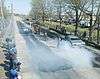
|
|
- This National Park Service list is complete through NPS recent listings posted December 16, 2016.[2]
Current listings
| [3] |
Name on the Register[4] |
Image |
Date listed[5] |
Location |
City or town |
Description |
|---|
| 1 |
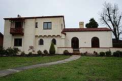
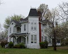
Beisel-Mitchell House |
|
000000001996-09-27-0000September 27, 1996
(#96001031) |
420 W. Court St.
36°03′21″N 90°29′27″W / 36.055833°N 90.490833°W / 36.055833; -90.490833 (Beisel-Mitchell House) |
Paragould |
|
| 2 |
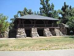
Crowley's Ridge State Park-Bathhouse |
|
000000001992-05-28-0000May 28, 1992
(#92000537) |
Main service center area access road in Crowley's Ridge State Park
36°02′45″N 90°39′50″W / 36.045833°N 90.663889°W / 36.045833; -90.663889 (Crowley's Ridge State Park-Bathhouse) |
Walcott |
|
| 3 |
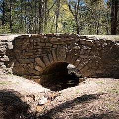
Crowley's Ridge State Park-Bridge |
|
000000001992-05-28-0000May 28, 1992
(#92000540) |
Main service center area access road in Crowley's Ridge State Park
36°02′42″N 90°39′47″W / 36.045°N 90.663056°W / 36.045; -90.663056 (Crowley's Ridge State Park-Bridge) |
Walcott |
|
| 4 |
Crowley's Ridge State Park-Comfort Station |
|
000000001992-05-28-0000May 28, 1992
(#92000538) |
Campground and cabin area access road in Crowley's Ridge State Park
36°02′37″N 90°39′37″W / 36.043611°N 90.660278°W / 36.043611; -90.660278 (Crowley's Ridge State Park-Comfort Station) |
Walcott |
|
| 5 |
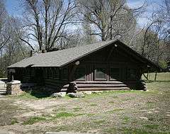
Crowley's Ridge State Park-Dining Hall |
|
000000001992-05-28-0000May 28, 1992
(#92000536) |
Employee housing area access road in Crowley's Ridge State Park
36°02′59″N 90°39′48″W / 36.049722°N 90.663333°W / 36.049722; -90.663333 (Crowley's Ridge State Park-Dining Hall) |
Walcott |
|
| 6 |
George Ray's Dragstrip |
|
000000002006-02-21-0000February 21, 2006
(#06000075) |
Highway 135, 0.5 miles south of U.S. Route 412
36°02′50″N 90°26′04″W / 36.047222°N 90.434444°W / 36.047222; -90.434444 (George Ray's Dragstrip) |
Paragould |
|
| 7 |
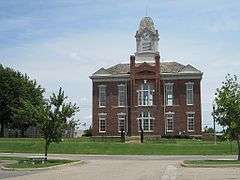
Greene County Courthouse |
|
000000001976-08-11-0000August 11, 1976
(#76000412) |
Court Sq.
36°03′14″N 90°29′12″W / 36.053889°N 90.486667°W / 36.053889; -90.486667 (Greene County Courthouse) |
Paragould |
|
| 8 |
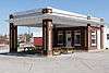
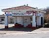
Gulf Oil Company Service Station |
|
000000001994-08-16-0000August 16, 1994
(#94000850) |
Southeastern corner of the junction of Main and S. 3rd Sts.
36°03′15″N 90°29′17″W / 36.054167°N 90.488056°W / 36.054167; -90.488056 (Gulf Oil Company Service Station) |
Paragould |
|
| 9 |
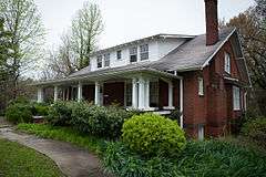
Highfill-McClure House |
|
000000002002-03-28-0000March 28, 2002
(#02000260) |
701 W. Highland St.
36°03′28″N 90°29′40″W / 36.057778°N 90.494444°W / 36.057778; -90.494444 (Highfill-McClure House) |
Paragould |
|
| 10 |
Jackson-Herget House |
|
000000001992-07-24-0000July 24, 1992
(#92000907) |
206 S. 4th St.
36°03′18″N 90°29′26″W / 36.055°N 90.490556°W / 36.055; -90.490556 (Jackson-Herget House) |
Paragould |
|
| 11 |
Linwood Mausoleum |
|
000000002007-01-29-0000January 29, 2007
(#06001314) |
Junction of W. Kingshighway and Linwood Dr.
36°03′04″N 90°30′11″W / 36.051111°N 90.503056°W / 36.051111; -90.503056 (Linwood Mausoleum) |
Paragould |
|
| 12 |
National Bank of Commerce Building |
|
000000001993-05-14-0000May 14, 1993
(#93000423) |
200 S. Pruett St.
36°03′19″N 90°29′11″W / 36.055278°N 90.486389°W / 36.055278; -90.486389 (National Bank of Commerce Building) |
Paragould |
|
| 13 |
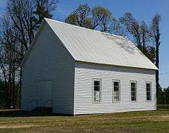
Old Bethel Methodist Church |
|
000000001978-04-19-0000April 19, 1978
(#78000590) |
West of Paragould off Highway 141
36°00′46″N 90°39′30″W / 36.012778°N 90.658333°W / 36.012778; -90.658333 (Old Bethel Methodist Church) |
Paragould |
|
| 14 |
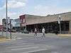
Paragould Downtown Commercial Historic District |
|
000000002003-07-18-0000July 18, 2003
(#03000646) |
Roughly bounded by 3rd Ave., Kings Highway, 3½ St., and W. Highland St.
36°03′19″N 90°29′13″W / 36.055278°N 90.486944°W / 36.055278; -90.486944 (Paragould Downtown Commercial Historic District) |
Paragould |
|
| 15 |
Paragould War Memorial |
|
000000001997-06-20-0000June 20, 1997
(#97000554) |
Junction of 3rd and Court Sts.
36°03′21″N 90°29′20″W / 36.055833°N 90.488889°W / 36.055833; -90.488889 (Paragould War Memorial) |
Paragould |
|
| 16 |
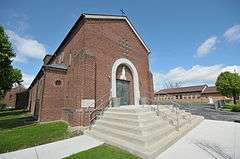
St. Mary's Catholic Church |
|
000000002015-01-27-0000January 27, 2015
(#14001198) |
301 W. Highland
36°03′30″N 90°29′16″W / 36.0584°N 90.4877°W / 36.0584; -90.4877 (St. Mary's Catholic Church) |
Paragould |
|
| 17 |
Texaco Station No. 1 |
|
000000002001-07-20-0000July 20, 2001
(#01000718) |
110 E. Main St.
36°03′16″N 90°29′09″W / 36.054444°N 90.485833°W / 36.054444; -90.485833 (Texaco Station No. 1) |
Paragould |
|
| [3] |
Name on the Register |
Image |
Date listed | Date removed |
Location |
City or town |
Summary |
|---|
| 1 |
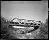
Big Slough Ditch Bridge |
Upload image |
000000002000-06-09-0000June 9, 2000
(#00000629) | 000000002004-09-24-0000September 24, 2004 |
County Road 855
|
Brighton vicinity |
|
| 2 |
Eight Mile Creek Bridge |
|
000000001990-01-01-00001990
(#90000524) | 000000002004-09-24-0000September 24, 2004 |
AR 135
|
Paragould vicinity |
|
See also
References
- ↑ The latitude and longitude information provided in this table was derived originally from the National Register Information System, which has been found to be fairly accurate for about 99% of listings. For about 1% of NRIS original coordinates, experience has shown that one or both coordinates are typos or otherwise extremely far off; some corrections may have been made. A more subtle problem causes many locations to be off by up to 150 yards, depending on location in the country: most NRIS coordinates were derived from tracing out latitude and longitudes off of USGS topographical quadrant maps created under the North American Datum of 1927, which differs from the current, highly accurate WGS84 GPS system used by most on-line maps. Chicago is about right, but NRIS longitudes in Washington are higher by about 4.5 seconds, and are lower by about 2.0 seconds in Maine. Latitudes differ by about 1.0 second in Florida. Some locations in this table may have been corrected to current GPS standards.
- ↑ "National Register of Historic Places: Weekly List Actions". National Park Service, United States Department of the Interior. Retrieved on December 16, 2016.
- 1 2 Numbers represent an ordering by significant words. Various colorings, defined here, differentiate National Historic Landmarks and historic districts from other NRHP buildings, structures, sites or objects.
- ↑ National Park Service (2009-03-13). "National Register Information System". National Register of Historic Places. National Park Service.
- ↑ The eight-digit number below each date is the number assigned to each location in the National Register Information System database, which can be viewed by clicking the number.
|
|---|
|
| Topics | |
|---|
|
| Lists by states | |
|---|
|
| Lists by insular areas | |
|---|
|
| Lists by associated states | |
|---|
|
| Other areas | |
|---|
|
-
 Portal Portal
-
 WikiProject WikiProject
|