| [3] |
Name on the Register[4] |
Image |
Date listed[5] |
Location |
City or town |
Description |
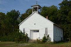
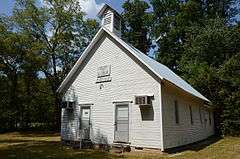
|---|
| 1 |
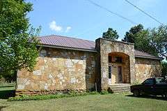
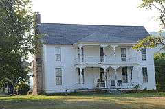
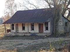
Jessie Abernathy House |
|
000000001985-09-17-0000September 17, 1985
(#85002216) |
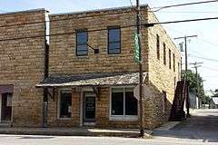
Off Highway 14
35°47′16″N 91°52′55″W / 35.787778°N 91.881944°W / 35.787778; -91.881944 (Jessie Abernathy House) |
Marcella |
|
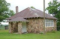
| 2 |
Alco School |
|
000000001992-09-04-0000September 4, 1992
(#92001125) |
Just north of Highway 66
35°53′28″N 92°22′21″W / 35.891111°N 92.3725°W / 35.891111; -92.3725 (Alco School) |
Alco |
|
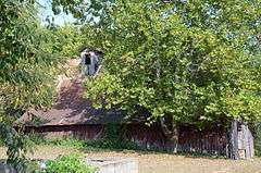
| 3 |
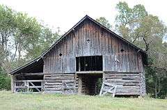
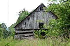
Clarence Anderson Barn |
|
000000001985-09-17-0000September 17, 1985
(#85002217) |
Highway 66
35°53′20″N 92°15′03″W / 35.888889°N 92.250833°W / 35.888889; -92.250833 (Clarence Anderson Barn) |
Newnata |
|
| 4 |
George Anderson House |
Upload image |
000000001985-09-17-0000September 17, 1985
(#85002218) |
West of Big Springs
35°54′03″N 92°16′56″W / 35.900833°N 92.282222°W / 35.900833; -92.282222 (George Anderson House) |
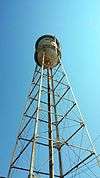
Big Springs |
|
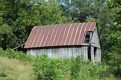
| 5 |
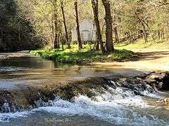
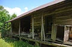
John Avey Barn |
|
000000001985-09-17-0000September 17, 1985
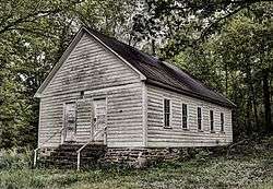
(#85002219) |
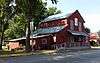
Off Highway 66
35°53′56″N 92°16′03″W / 35.898889°N 92.2675°W / 35.898889; -92.2675 (John Avey Barn) |
Big Springs |
|
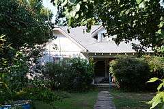
| 6 |
John Bettis House |
|
000000001985-09-17-0000September 17, 1985
(#85002220) |
Highway 14
35°48′53″N 91°54′18″W / 35.814722°N 91.905°W / 35.814722; -91.905 (John Bettis House) |
Pleasant Grove |
|
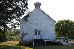
| 7 |
Bluff Springs Church and School |
|
000000001985-09-17-0000September 17, 1985
(#85002210) |
3.5 miles west of Onia
35°55′29″N 92°23′41″W / 35.924722°N 92.394722°W / 35.924722; -92.394722 (Bluff Springs Church and School) |
Onia |
|
| 8 |
Bonds House |
Upload image |
000000001992-02-03-0000February 3, 1992
(#91000691) |
County Road 2 east of Meadow Creek
35°46′17″N 92°20′43″W / 35.771389°N 92.345278°W / 35.771389; -92.345278 (Bonds House) |
Fox |
|
| 9 |
Brewer's Mill |
|
000000001985-09-17-0000September 17, 1985
(#85002221) |
Highway 66
35°52′05″N 92°07′15″W / 35.868056°N 92.120833°W / 35.868056; -92.120833 (Brewer's Mill) |
Mountain View |
|
| 10 |
A.B. Brewer Building |
|
000000001985-10-25-0000October 25, 1985
(#85003395) |
Highway 66
35°52′06″N 92°07′06″W / 35.868333°N 92.118333°W / 35.868333; -92.118333 (A.B. Brewer Building) |
Mountain View |
|
| 11 |
John F. Brewer House |
|
000000001985-10-25-0000October 25, 1985
(#85003398) |
Highway 9
35°52′03″N 92°07′06″W / 35.8675°N 92.118333°W / 35.8675; -92.118333 (John F. Brewer House) |
Mountain View |
|
| 12 |
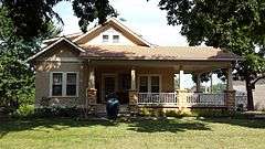
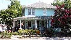
Samuel Brown House |
|
000000001985-09-17-0000September 17, 1985
(#85002204) |
Off Highway 9
35°49′49″N 92°08′39″W / 35.830278°N 92.144167°W / 35.830278; -92.144167 (Samuel Brown House) |
West Richwoods |
|
| 13 |
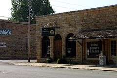
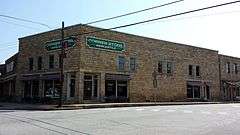
C.B. Case Motor Co. Building |
|
000000001985-09-17-0000September 17, 1985
(#85002222) |
103 E Main St
35°52′08″N 92°07′08″W / 35.868889°N 92.118889°W / 35.868889; -92.118889 (C.B. Case Motor Co. Building) |
Mountain View |
|
| 14 |
Clark-King House |
|
000000001985-09-17-0000September 17, 1985
(#85002234) |
Northeast of Mountain View
35°53′04″N 92°07′32″W / 35.884444°N 92.125556°W / 35.884444; -92.125556 (Clark-King House) |
Mountain View |
|
| 15 |
Commercial Hotel |
|
000000001985-09-17-0000September 17, 1985
(#85002223) |
100 W Washington St
35°52′10″N 92°07′03″W / 35.869444°N 92.1175°W / 35.869444; -92.1175 (Commercial Hotel) |
Mountain View |
|
| 16 |
Henry Copeland House |
|
000000001985-09-17-0000September 17, 1985
(#85002224) |
Highway 14
35°48′56″N 91°54′29″W / 35.815556°N 91.908056°W / 35.815556; -91.908056 (Henry Copeland House) |
Pleasant Grove |
|
| 17 |
Wesley Copeland House |
Upload image |
000000001985-09-17-0000September 17, 1985
(#85002208) |
Southeast of Timbo
35°51′11″N 92°18′25″W / 35.853056°N 92.306944°W / 35.853056; -92.306944 (Wesley Copeland House) |
Timbo |
|
| 18 |
Davis Barn |
Upload image |
000000001985-09-17-0000September 17, 1985
(#85002225) |
West of Pleasant Grove
35°48′43″N 91°55′40″W / 35.811944°N 91.927778°W / 35.811944; -91.927778 (Davis Barn) |
Pleasant Grove |
|
| 19 |
Dew Drop Inn |
|
000000001985-09-17-0000September 17, 1985
(#85002231) |
307 W. Washington St.
35°52′10″N 92°07′13″W / 35.869444°N 92.120278°W / 35.869444; -92.120278 (Dew Drop Inn) |
Mountain View |
|
| 20 |
William Dillard Homestead |
|
000000001985-09-17-0000September 17, 1985
(#85002214) |
Near the White River
35°56′00″N 92°02′04″W / 35.933333°N 92.034444°W / 35.933333; -92.034444 (William Dillard Homestead) |
Round Bottom |
|
| 21 |
H.J. Doughtery House |
Upload image |
000000001985-09-17-0000September 17, 1985
(#85002232) |
Highway 14
35°47′31″N 91°53′03″W / 35.791944°N 91.884167°W / 35.791944; -91.884167 (H.J. Doughtery House) |
Marcella |
|
| 22 |
Farmers and Merchants Bank |
|
000000001985-09-17-0000September 17, 1985
(#85002228) |
Highway 66
35°52′07″N 92°07′02″W / 35.868611°N 92.117222°W / 35.868611; -92.117222 (Farmers and Merchants Bank) |
Mountain View |
|
| 23 |
Zachariah Ford House |
|
000000001985-09-17-0000September 17, 1985
(#85002206) |
Near the White River
35°51′07″N 91°52′04″W / 35.851944°N 91.867778°W / 35.851944; -91.867778 (Zachariah Ford House) |
Pleasant Grove |
|
| 24 |
Fox Pictograph |
Upload image |
000000001982-05-04-0000May 4, 1982
(#82002143) |
Address Restricted
|
Fox |
|
| 25 |
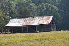
Orvall Gammill Barn |
|
000000001985-09-17-0000September 17, 1985
(#85002229) |
Northwest of Big Springs
35°54′36″N 92°16′25″W / 35.91°N 92.273611°W / 35.91; -92.273611 (Orvall Gammill Barn) |
Big Springs |
|
| 26 |
Walter Gray House |
|
000000001985-09-17-0000September 17, 1985
(#85002212) |
Off Highway 14
35°44′20″N 91°51′04″W / 35.738889°N 91.851111°W / 35.738889; -91.851111 (Walter Gray House) |
Melrose |
|
| 27 |
Joe Guffey House |
Upload image |
000000001985-09-17-0000September 17, 1985
(#85002211) |
Highway 110
35°43′12″N 92°24′34″W / 35.72°N 92.409444°W / 35.72; -92.409444 (Joe Guffey House) |
Old Lexington |
No longer standing
|
| 28 |
Binks Hess House and Barn |
Upload image |
000000001985-09-17-0000September 17, 1985
(#85002227) |
Off Highway 14
35°47′20″N 91°52′53″W / 35.788889°N 91.881389°W / 35.788889; -91.881389 (Binks Hess House and Barn) |
Marcella |
|
| 29 |
Thomas E. Hess House |
|
000000001983-12-27-0000December 27, 1983
(#83003548) |
Highway 14
35°47′19″N 91°53′05″W / 35.788611°N 91.884722°W / 35.788611; -91.884722 (Thomas E. Hess House) |
Marcella |
|
| 30 |
Thomas M. Hess House |
Upload image |
000000001985-09-17-0000September 17, 1985
(#85002226) |
Off Highway 14
35°47′24″N 91°52′45″W / 35.79°N 91.879167°W / 35.79; -91.879167 (Thomas M. Hess House) |
Marcella |
|
| 31 |
Miles Jeffery Barn |
Upload image |
000000001985-09-17-0000September 17, 1985
(#85002215) |
Off Highway 5
35°59′11″N 92°07′21″W / 35.986389°N 92.1225°W / 35.986389; -92.1225 (Miles Jeffery Barn) |
Optimus |
|
| 32 |
Lackey General Merchandise and Warehouse |
|
000000001985-09-17-0000September 17, 1985
(#85002233) |
Highway 66
35°52′07″N 92°07′03″W / 35.868611°N 92.1175°W / 35.868611; -92.1175 (Lackey General Merchandise and Warehouse) |
Mountain View |
|
| 33 |
George W. Lackey House |
|
000000001990-10-02-0000October 2, 1990
(#90000992) |
Junction of King and Washington Sts.
35°52′10″N 92°07′07″W / 35.869444°N 92.118611°W / 35.869444; -92.118611 (George W. Lackey House) |
Mountain View |
|
| 34 |
Fred Lancaster Barn |
|
000000001985-09-17-0000September 17, 1985
(#85002213) |
Near the White River
35°56′19″N 92°02′45″W / 35.938611°N 92.045833°W / 35.938611; -92.045833 (Fred Lancaster Barn) |
Round Bottom |
|
| 35 |
Luber School |
|
000000001992-09-04-0000September 4, 1992
(#92001124) |
County Road 214
35°46′11″N 92°05′15″W / 35.769722°N 92.0875°W / 35.769722; -92.0875 (Luber School) |
Luber |
|
| 36 |
H.S. Mabry Barn |
|
000000001985-09-17-0000September 17, 1985
(#85002236) |
Near Johnson Creek
35°49′11″N 92°06′53″W / 35.819722°N 92.114722°W / 35.819722; -92.114722 (H.S. Mabry Barn) |
East Richwoods |
|
| 37 |
Marcella Church & School |
|
000000001985-09-17-0000September 17, 1985
(#85002237) |
Highway 14
35°47′16″N 91°53′03″W / 35.787778°N 91.884167°W / 35.787778; -91.884167 (Marcella Church & School) |
Marcella |
|
| 38 |
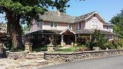
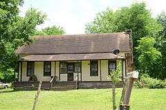
Owen Martin House |
|
000000001985-10-25-0000October 25, 1985
(#85003397) |
Highway 14
35°47′14″N 91°53′07″W / 35.787222°N 91.885278°W / 35.787222; -91.885278 (Owen Martin House) |
Marcella |
|
| 39 |
Noah McCarn House |
Upload image |
000000001985-09-17-0000September 17, 1985
(#85002238) |
Highway 5
35°49′16″N 92°02′27″W / 35.821111°N 92.040833°W / 35.821111; -92.040833 (Noah McCarn House) |
Mountain View |
Demolished in 2010
|
| 40 |
Mirror Lake Historic District |
|
000000001995-09-11-0000September 11, 1995
(#94001614) |
Forest Service Road 1110E
35°57′37″N 92°10′26″W / 35.960278°N 92.173889°W / 35.960278; -92.173889 (Mirror Lake Historic District) |
Ozark National Forest |
|
| 41 |
Jim Morris Barn |
Upload image |
000000001985-09-17-0000September 17, 1985
(#85002209) |
Highway 66
35°52′07″N 92°18′40″W / 35.868611°N 92.311111°W / 35.868611; -92.311111 (Jim Morris Barn) |
Timbo |
|
| 42 |
Mountain View Waterworks |
|
000000002006-10-05-0000October 5, 2006
(#06000906) |
Junction of Clarence St. and King St.
35°52′22″N 92°07′10″W / 35.872778°N 92.119444°W / 35.872778; -92.119444 (Mountain View Waterworks) |
Mountain View |
|
| 43 |
Newton Sutterfield Farmstead |
|
000000002003-05-20-0000May 20, 2003
(#03000398) |
1797 Horton Hill Rd.
35°54′44″N 92°23′29″W / 35.912222°N 92.391389°W / 35.912222; -92.391389 (Newton Sutterfield Farmstead) |
Alco |
|
| 44 |
Noricks Chapel School |
|
000000001998-06-04-0000June 4, 1998
(#98000615) |
Meisenheimer Rd., 10 miles southeast of Mountain View
35°47′08″N 92°01′12″W / 35.785556°N 92.02°W / 35.785556; -92.02 (Noricks Chapel School) |
Mountain View |
|
| 45 |
North Sylamore Creek Bridge |
Upload image |
000000002010-02-24-0000February 24, 2010
(#10000034) |
Forest Service Road 1102 over N. Sylamore Creek
35°59′44″N 92°12′46″W / 35.99555°N 92.212736°W / 35.99555; -92.212736 (North Sylamore Creek Bridge) |
Ozark National Forest |
|
| 46 |
Pictograph Cave |
Upload image |
000000001982-05-04-0000May 4, 1982
(#82002144) |
Address Restricted
|
Mountain View |
|
| 47 |
Pinky Pruitt Barn |
|
000000001985-09-17-0000September 17, 1985
(#85002239) |
Highway 14
35°50′17″N 91°56′07″W / 35.838056°N 91.935278°W / 35.838056; -91.935278 (Pinky Pruitt Barn) |
St. James |
|
| 48 |
Roasting Ear Church and School |
|
000000001985-09-17-0000September 17, 1985
(#85002230) |
Northeast of Onia
35°56′51″N 92°17′20″W / 35.9475°N 92.288889°W / 35.9475; -92.288889 (Roasting Ear Church and School) |
Onia |
|
| 49 |
C.L. Smith & Son General Store |
|
000000001985-09-17-0000September 17, 1985
(#85002240) |
Highway 66
35°52′06″N 92°07′05″W / 35.868333°N 92.118056°W / 35.868333; -92.118056 (C.L. Smith & Son General Store) |
Mountain View |
|
| 50 |
Stegall General Store |
|
000000001985-09-17-0000September 17, 1985
(#85002241) |
104 W. Main St.
35°52′06″N 92°07′05″W / 35.868333°N 92.118056°W / 35.868333; -92.118056 (Stegall General Store) |
Mountain View |
|
| 51 |
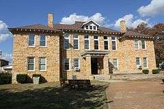
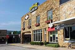
Stone County Courthouse |
|
000000001976-09-29-0000September 29, 1976
(#76000470) |
Courthouse Sq.
35°52′08″N 92°07′05″W / 35.868889°N 92.118056°W / 35.868889; -92.118056 (Stone County Courthouse) |
Mountain View |
|
| 52 |
Sugarloaf Fire Tower Historic District |
Upload image |
000000001995-09-11-0000September 11, 1995
(#94001615) |
Forest Service Road 1123
36°05′02″N 92°09′48″W / 36.083889°N 92.163333°W / 36.083889; -92.163333 (Sugarloaf Fire Tower Historic District) |
Ozark National Forest |
|
| 53 |
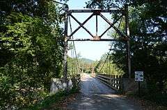
Sylamore Creek Bridge |
|
000000001999-11-18-0000November 18, 1999
(#99001353) |
County Road 283 over Sylamore Creek
35°56′09″N 92°07′18″W / 35.935833°N 92.121667°W / 35.935833; -92.121667 (Sylamore Creek Bridge) |
Allison |
|
| 54 |
Taylor-Stokes House |
Upload image |
000000001985-09-17-0000September 17, 1985
(#85002207) |
Off Highway 14
35°45′36″N 91°51′57″W / 35.76°N 91.865833°W / 35.76; -91.865833 (Taylor-Stokes House) |
Marcella |
|
| 55 |
Turkey Creek School |
|
000000001985-10-25-0000October 25, 1985
(#85003396) |
Highway 9
35°45′31″N 92°13′54″W / 35.758611°N 92.231667°W / 35.758611; -92.231667 (Turkey Creek School) |
Turkey Creek |
|
| 56 |
West Richwoods Church & School |
|
000000001985-09-17-0000September 17, 1985
(#85002205) |
Highway 9
35°49′35″N 92°10′19″W / 35.826389°N 92.171944°W / 35.826389; -92.171944 (West Richwoods Church & School) |
West Richwoods |
|


.JPG)


.JPG)