Hume Highway
| Hume Highway Hume Freeway / Hume Motorway New South Wales–Victoria | |
|---|---|
 | |
| General information | |
| Type | Freeway |
| Length | 838 km (521 mi) |
| Opened | 1817 |
| Route number(s) |
|
| Former route number | see Former route allocations |
| Major junctions | |
| NE end | |
| |
| SW end | |
| Location(s) | |
| Major suburbs / towns | Goulburn, Yass, Tarcutta, Albury, Wodonga, Wangaratta, Benalla, Seymour, Craigieburn |
| Highway system | |
|
Highways in Australia National Highway • Freeways in Australia Highways in New South Wales Highways in Victoria | |
| |
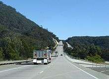
The Hume Highway, inclusive of the sections now known as the Hume Freeway and Hume Motorway, is one of Australia's major inter-city highways, running for 807 kilometres (501 mi) between Melbourne and Sydney.[1] Upgrading of the entire route to dual carriageway was completed on 7 August 2013.[2]
The road is called the Hume Freeway in Victoria, the Hume Motorway between Prestons and Berrima, New South Wales, and the Hume Highway elsewhere in New South Wales. It is part of the Auslink National Network and is a vital link for road freight to transport goods to and from the two cities as well as serving Albury-Wodonga and Canberra.
The main alternative route between Sydney and Melbourne is the Princes Highway/Princes Freeway/Princes Motorway route (A1/M1) which follows the coast for most of its length. Other inland alternate routes include the Olympic Highway route (A41) between Albury and Sydney via Cowra and Bathurst, and also the Federal Highway / Monaro Highway route (M23/A23/B23) via Canberra which links with the Hume Highway near Goulburn and the Princes Highway in East Gippsland.
In NSW during 2013, the National Highway shield, National Highway 31, was replaced with a standard alphanumeric route number, the M31 south of Prestons (along with the A22 east of Liverpool into the Sydney CBD and the A28 for a short length through Liverpool). This re-numbering for the first time in over 20 years created one continuously signed route along the Hume Highway, having already been signed the M31 in Victoria during the 1990s. During 2013 the route between Berrima and Prestons was also renamed the Hume Motorway.
History
The coast of New South Wales from the Queensland border to the Victorian border is separated from the inland by an escarpment, forming the eastern edge of the Great Dividing Range. There are few easy routes up this escarpment. To climb from the coast to the tablelands the Hume Highway uses the Bargo Ramp, a geological feature which provides one of the few easy crossings of the escarpment.
In the first twenty years of European settlement at Sydney (established 1788), exploration southwest of Sydney was slow. This area was heavily wooded at the time, especially the "Bargo brush", which was regarded as almost impenetrable. In 1798 explorers (Wilson, Price, Hacking, and Collins) reached the Moss Vale and Marulan districts, but this was not followed up. Any settlement would have to await the construction of an adequate access track, which would have been beyond the colony's resources at the time, and would have served little purpose as a source of supplies for Sydney, due to the time taken to reach Sydney. In 1804, Charles Throsby penetrated through the Bargo brush to the country on the tablelands near Moss Vale and Sutton Forest. On another expedition in 1818, he reached Lake Bathurst and the "Goulburn Plains".[3] Many of the early explorers would most likely have used aboriginal guides, but they do not appear to have given them credit.
After Charles Throsby's 1818 journey towards present day Goulburn, followed by Hamilton Hume and William Hovell's overland journey from Appin (near Campbelltown) to Port Phillip and return in 1824, development of the Southern Tablelands for agriculture was rapid. The present route of the Hume Highway is much the same as that used by the pioneers.
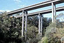
The route taken by the Hume Highway to climb from the coast to the Southern Tablelands and thence across the Great Divide is situated between the parallel river gorge systems of the Wollondilly and Shoalhaven Rivers. This country consists generally of a gently sloping plateau which is deeply dissected by the Nepean River and its tributaries. The route of the Highway, by using four high-level bridges to cross these gorges, avoids the Razorback Range, and has minimal earthworks. The climb from the western side of the Nepean River at Menangle up to Mittagong is fairly sustained, a fact that is hard to appreciate at high speed on the modern freeway. The highway climbs non-stop over a distance of 16 km from the Pheasant's Nest bridge over the Nepean River to Yerrinbool, before dropping slightly before the final climb to reach the tablelands at Aylmerton.
Early road construction
Governor Lachlan Macquarie ordered the construction of a road, which became known as the Great South Road (the basis of the northern end of the Hume Highway) in 1819 from Picton to the Goulburn Plains and he travelled to Goulburn in 1820, but it is unlikely that even a primitive road was finished at that time.
The Great South Road was rebuilt and completely re-routed between Yanderra and Goulburn by Surveyor-General Thomas Mitchell in 1833. The Main Roads Management Act of June 1858 declared the Great Southern Road, from near Sydney through Goulburn and Gundagai to Albury, as one of the three main roads in the colony. However, its southern reaches were described as only a 'scarcely formed bullock track' as late as 1858. The road was improved in the mid-1860s with some sections near Gundagai "metalled" and all creeks bridged between Adelong Creek (approximately 10 kilometres south of Gundagai and now known as the village of Tumblong) and Albury.[4]
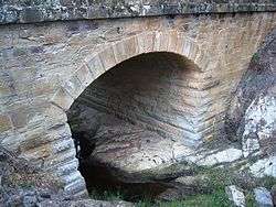
Mitchell's route, except for the bypasses at Mittagong, Berrima and Marulan (dual carriageways were completed in 1986) is still largely followed by the current highway. Mitchell intended to straighten the route north of Yanderra, but was not granted funding, although his proposed route through Pheasants Nest has similarities to the freeway route opened in 1980.[5] Mitchell's work on the Great South Road is best preserved at Towrang Creek (10 kilometres north of Goulburn), where his stone arch culvert still stands, although it was superseded in 1965 by a concrete box culvert which in turn was superseded by the current route of the highway when it was duplicated in 1972.
In 1914 the NSW section of the highway was declared a main road. Until it was named the Hume Highway in 1928 it was known as the "Great South Road" in NSW and "Sydney Road" in Victoria. It was named after Hamilton Hume, who with William Hovell were the first Europeans to traverse an overland route between Sydney and Port Phillip, in what later became Victoria.
Timeline of duplication and bypass works
Duplication works on the highway began in the 1960s and concluded in 2013.[2] The entire route between Sydney and Melbourne is now a dual carriageway, limited access highway.
- 1962 - Chiltern to Barnawartha opened January, 1962. This is referred to as the ‘Hume By-pass Road’. Although initially opened as a single carriageway, two lane bypass, it was the first rural bypass of a Victorian town (Chiltern) on the Hume Highway and was designed to allow for the future construction of a second carriageway.[6]
- 1962 - Craigieburn ‘Hume By-pass Road’ opened January, 1962 at a cost of 388,000 Australian Pounds. This dual carriageway bypass over the Sydney to Melbourne railway and Craigieburn Road has since been bypassed itself by the M31 Hume Freeway bypass, opened in 2007.[6]
- 1965/66 - Broadford to Tallarook. Duplication of 4 miles completed during the financial year.[7]
- 1966 - 1.6 km of dual carriageway opened over Bendooley Hill between Mittagong and Berrima (superseded by Berrima bypass in 1989).
- 1966/67 - Craigieburn to Kalkallo. 4.4 miles of dual carriageways completed during the financial year.[8]
- 1966/67 - Tallarook. 1.4 miles completed south of Tallarook and 1.3 miles completed north of Tallarook during the financial year.[8]
- 1967/68 - Kalkallo to Beveridge. 4.1 miles of dual carriageways completed during the financial year.[9]
- 1969/70 - Beveridge. Completion of 11 miles of dual carriageway during the financial year, including a deviation at Beveridge and continuation south to connect with existing dual carriageways north of Craigieburn.[10]
- 1970/71 - Tallarook bypass. 4.5 mile bypass of Tallarook opened during the financial year.[11]
- 1973 - stage 1 of Camden bypass (Macarthur Bridge across Nepean River floodplain) opened.
- 1973 - first section of South Western Expressway (9.8 km), later subsumed into the Hume Highway, was opened from Cross Roads to Campbelltown Rd Raby on 26 October.
- 1974 - stage 2 of Camden bypass (new dual carriageway route Narellan Rd-Macarthur Bridge) opened.
- 1974 - second section of South Western Expressway (5.8 km), also later subsumed into the Hume Highway, was opened from Campbelltown Rd Raby to Narellan Rd Macarthur on 16 December.
- 1976 - Wallan to Broadford section opened 3 May 1976, by the Premier of Victoria, the Hon R J Hamer, ED, MP. At that time it was the longest section of freeway ever opened at one time in Victoria (34 km) and was the 'single biggest construction project carried out by the CRB since its inception in 1913'.[12]
- 1977 - new route of Hume Highway, built to freeway standard, opened from Yanderra to Aylmerton (13.5 km) on 24 May.
- 1979 - Violet Town to Baddaginnie. 10 km of dual carriageways opened early 1979 at a cost of A$5.1m.[13]
- 1979 - Avenel to Tubbs Hill, near Longwood. 14.5 km duplication opened 19 December 1979, by the Minister for Transport, the Hon Robert Maclellan MLA, at a cost of A$6.5m.[13]
- 1980 - Violet Town bypass. 12 km from Wibrahams Road to the existing freeway at One Mile Creek, opened 21 March 1980, by the Minister for Transport, the Hon Robert Maclellan MLA at a cost of A$11m.[14]
- 1980 – 35 km deviation of Hume Highway bypassing the Razorback Range opened on 15 December from Narellan Rd Macarthur to Yanderra, connecting sections opened December 1974 and May 1977.
- 1981 - Avenel bypass. 16 km north-east from the Goulburn Valley Highway interchange, opened 1 December 1981 by the Minister for Transport, the Hon Robert Maclellan MLA at a cost of A$25m.[15]
- 1982 – Seymour bypass opened 14 December 1982 by the Minister for Transport, the Hon. Steve Crabb MP. The 9 km bypass cost A$26m to complete. At this stage, although largely opened to traffic, a one kilometre section of south bound carriageway south of Seymour was still under construction.[16]
- 1984 – Longwood section. This 10 km section from Oxenburys Road to Creighton Road was opened by the Assistant Minister of Transport, the Hon. Jack Simpson MP, on 18 May 1984. The project cost A$10m. The opening marked the halfway point for the duplication of the highway within Victoria, with the total length of dual carriageways at that point measuring 151 km.[17]
- 1985 – Barnawartha to Wodonga duplication, from Hanson Road to Parkers Road. An initial 4 km of the 12.6 km duplicate carriageway was completed in 1985.[18]
- 1986 - 7.3 km Marulan Bypass opened on 27 November 1986.[19]
- 1987 – Benalla bypass opened March 1987. The 36.5 km bypass was at this time the longest stretch of highway duplication opened at once in Victoria. The project cost was A$70m and extended from south of Baddaginnie to Chivers Road, south of Glenrowan.[18]
- 1987/88 – Barnawartha to Wodonga, from Hanson Road to Parkers Road. The remaining 8.6 km of the 12.6 km duplicate carriageway was expected to be open to traffic in ‘the second half of 1987’.[18]
- 1987/88 – Chiltern to Barnawartha. 21 km A$31m duplication from Gilmours Road to Hanson Road was expected to be ‘opened to traffic in stages from July 1987 until late 1989’.[18]
- 1988/89 – 12.5 km Glenrowan bypass completed during the financial year at a cost of A$31.5m.[20]
- 1989 - Berrima Bypass. 15.5 km-long bypass officially opened to traffic on 22 March 1989 at a total cost of A$80m.[19]
- 1990 – Springhurst to Chiltern, Victoria. This 5.2 km duplication opened to traffic in March 1990, at a cost of A$8.5m.[21]
- 1990 – Euroa to Balmattum, Victoria. Duplication of this 8 km section was opened to traffic in June 1990, at a cost of A$16m.[21]
- 1990 – The 3.3 km Barnawartha (Victoria) bypass was fully completed and opened to traffic in June 1990, at a cost of A$11m.[21]
- 1991 – 3.3 km duplication north of Springhurst opened in November 1991.[22]
- 1991 – 10 km duplication from Coppabella Road to Reedy Creek completed on 17 December 1991.[19]
- 1992 – Euroa bypass opened to traffic on 3 April 1992, at a cost of A$43m - A$2m under budget.[22]
- 1992 - Mittagong Bypass. Originally part of the 1970s/1980's F5 project, this 8.2 km-long bypass was opened on 17 August 1992 at a completed cost of A$83m.[19][23]
- 1992 – 13 km Goulburn Bypass opened to traffic on 5 December 1992 at a completed cost of A$84m.[19][23]
- 1993 - Cullerin Range Deviation. 34 km-long freeway-grade deviation officially opened on 5 April 1993 at a cost of A$132m.[19][23]
- 1994 - Springhurst bypass. 5 km opened to traffic in March 1994, at a cost of A$7.7m.[24]
- 1994 - Wangaratta bypass. A$80m 20 km bypass opened to traffic in April 1994, eight months ahead of schedule and A$30m under budget. This was the final section of the Hume Highway in Victoria to be duplicated.[24]
- 1994 - Yass Bypass. 18 km dual-carriageway officially opened on 25 July 1994 at a total cost of A$106m.[19][25]
- 1995 - Cullerin to Yass Duplication. First 11 km section opened on 14 September 1994, followed by the second 6 km section on 3 May 1995. Final cost was A$59.1m.[19][25]
- 1995 - Jugiong Bypass. 13 km dual-carriageway opened on 11 October 1995 at a total cost of A$85.5m.[19][26]
- 1996 - Tarcutta Range Deviation. A$52.6m 9.4 km-long upgrade south of Tumblong opened to traffic on 3 May 1996.[19][26]
- 2004 - Craigieburn bypass (section one) opened to traffic December 2004 between the Metropolitan Ring Road and Cooper Street.[27]
- 2005 - Craigieburn bypass (section two) opened December 2005, completing the A$305m 17 km bypass.[28]
- 2007 - Albury-Wodonga bypass. Construction commenced in May 2005 and was opened to traffic on 6 March 2007. The NSW section comprised 14.6 km from Ettamogah to the Murray River through the city of Albury. The Australian Government fully funded the A$374 million NSW section of the project.[29] The A$150m Victorian section was largely funded by the federal government, with the A$5.8m Bandiana Link funded by the State Government of Victoria.[30]
- 2009 - Southern Hume Highway Duplication. Work began in October 2007 and the 65 km section (2 km shorter than the previous highway route) was progressively opened to traffic from mid 2009 and completed in December 2009. Completion of this section left only 21 km of the Hume Highway as single carriageway, through the towns of Tarcutta, Holbrook and Woomargama.[31]
.jpg)
- 2009 - Coolac Bypass. Construction began in May 2007. The 12 km bypass was opened to traffic in August 2009. The project was fully funded by the Australian Government at a cost of A$171 million.[31]
- 2009 - Sheahan Bridge duplication, Gundagai. This A$70.6 million project was fully funded by the Australian Government and was completed in 2009. Traffic was switched to the new bridge in May 2009 to enable essential maintenance on the existing bridge. Both bridges were available to traffic as dual carriageways in December 2009.[31]
- 2011 - Woomargama Bypass. This 9 km bypass was opened on 7 November 2011. The A$265 million project was funded by the Australian Government.[32]
- 2011 - Tarcutta Bypass. The 7 km Tarcutta Bypass was opened to traffic on 15 November 2011. The A$290 million project was funded by the Australian Government.[32]
- 2013 - Holbrook bypass. In June 2013, Roads and Maritime celebrated the imminent completion of the duplication of the Hume Highway with a community day at the Holbrook Bypass.[33]
Route
_Distances_Updated.gif)
_Distances.gif)
At its Sydney end, the Hume Highway begins at Parramatta Road, in Summer Hill. This route is numbered as A22. The first 35 km of the highway was known as Liverpool Road until August 1928, when it was renamed as part of the Hume or Great Southern Highway, as part of the creation of the NSW highway system. Sections of the highway through Sydney's suburbs continue to be also known by its former names of Liverpool Road, Sydney Road and Copeland Street (through Liverpool).
The main Hume Highway effectively commences at the junction of the M5 South Western Motorway and the Westlink M7 at Casula. Heading eastbound, the M5 provides access to Sydney Airport and the CBD; while the M7 provides access to Newcastle and Brisbane bypassing the Sydney CBD. Both of these routes are tolled.
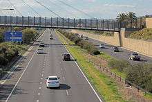
Other than sections within the urban areas of Sydney and Melbourne, the Hume Highway is dual carriageway or expressway standard for its full length in Victoria and New South Wales.
Although the full length of the Hume Highway is dual carriageway (with at-grade intersections and restricted entry from adjoining land), there are considerable lengths of the highway which are of full freeway standard. Most of these sections are bypasses of the larger towns on the route, where the need to deviate the route to construct the bypass made it practical to deny access from adjoining land and thus provide full freeway conditions. In addition to these bypasses the sections between Casula (in southwestern Sydney) and Berrima (built 1973–92), and Broadford to Wallan (1976), which both were constructed as major deviations, are also of full freeway standard. The entire section in Victoria is categorised as a freeway by government roads authority VicRoads, although there a few intersections along the route that are not yet grade-separated. The speed limit on the full length of the highway is 110 km/h (70 mph).
As the Hume Freeway approaches Melbourne at the suburb of Craigieburn, 27 km north of the city centre, the Craigieburn Bypass now diverts the Hume Freeway (and the M31 designation) to the east of the former route, to terminate at the Western Ring Road/Metropolitan Ring Road (M80). This bypass was opened in two stages, in December 2004 and December 2005.
At its Melbourne end, the original alignment of the Melbourne–Sydney route followed Royal Parade northward from where it begins at its intersection with Elizabeth Street and Flemington Road. Royal Parade becomes Sydney Road at Brunswick Road and then became the Hume Highway itself at Campbellfield. This ceased to be the designated route of the Hume Highway in 1992, with the completion of Stage 1 of the Western Ring Road, at which point the designation of the southbound highway was truncated. The former highway south from the Western Ring Road to Elizabeth street is route is now numbered as State Route 55 and is now officially called Sydney Road (Hume Highway).
Recent New South Wales upgrading

Between February 2009 and March 2012, both carriageways were widened between Brooks Road and Narellan Road. This work was undertaken in 3 stages. The first stage, widening to 4 lanes each way between Brooks Road and St Andrews Road St Andrews was completed in 2010. The second stage, widening to 4 lanes each way between St Andrews Road and Raby Road commenced in 2009 and was completed in mid-2011. The final stage, widening to 3 lanes each way between Raby Road and Narellan Road, commenced in September 2010 and was completed in March 2012.[34] Construction of a pedestrian bridge over the highway to link Claymore and Woodbine was also completed. This section of the highway, opened as part of the two stages opened in October 1973 and December 1974, was originally designed for widening of the carriageways to three lanes.
Work commenced in 2010 on a 9.5 km (5.9 mi) bypass of Holbrook. The bypass was opened to traffic on 7 August 2013 after being postponed due to wet weather.[35][36][37] The opening of the bypass resulted in dual carriageway (much to freeway standard) over the full length of the Hume Highway for the first time.
Current Victorian Upgrade Projects
VicRoads has undertaken a planning study for the upgrading of the Hume Freeway by removal of direct access from adjoining properties and grade-separation of the intersections between Kalkallo and Beveridge. These intersections have the highest accident rate of the Hume Freeway in Victoria.[38] The study, completed in March 2009, intended to amend council planning schemes so as to reserve space for the upgrade, but no timetable has been set for the project.[39]
In addition a 4-level interchange between the Hume Freeway and the Outer Metropolitan Ring Road is proposed for construction after 2020.[40][41]
Landscapes
Heading north from Melbourne, the road passes through the hills of the Great Dividing Range, some of which is covered with box eucalypt forest but of which much is cleared for farmland, before levelling out near Seymour to cross flat, mostly cleared farming country to Wodonga and the Victoria-New South Wales border. Victoria's landscape differs to that of the typical 'true Australian Outback', but a dry summer can leave the ground parched. Mount Buffalo can be seen in the distance to the east as the highway comes down off the Warby Range near Glenrowan, and a museum commemorating Ned Kelly is located nearby. At Wangaratta the highway passes close to the Rutherglen and Milawa wine-producing areas.
Continuing north, the Murray River, the south bank of which is the Victoria-New South Wales border, is crossed on the bypass of Albury-Wodonga. From Albury, the highway skirts Lake Hume and continues across undulating country generally north-east towards Holbrook and then Tarcutta. Just north of Tarcutta the highway encounters the first of several ranges which form outliers of the Great Dividing Range, and which are crossed as the highway climbs the slopes to the tablelands west of Yass. From here the highway runs eastward, to Goulburn where it again turns northeast. Most of the New South Wales countryside from Albury to Marulan has been developed for wool production, with Yass and Goulburn in particular noted for their fine wool.
Fixed speed camera locations
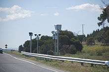
In April 2007, 'point-to-point' fixed speed-camera sites were installed, in the median strip along the Craigieburn Bypass section and northward to Broadford, in Victoria, at roughly 15–20 km intervals. These measure both instantaneous (flash photography) speed and its speciality in the point-to-point versions (between two or more sites and then the average speed is measured to the fixed speed limit, comparing how long it takes a vehicle to reach one point from another). There are five sites, with two cameras (radar version) at each, totalling ten altogether.[42]
In Sydney: next to Ashfield Primary School, near Culdees Road Burwood, Willee St Enfield, Stacey St Bankstown, Brennan St Yagoona, and Knight St Lansvale.
Former route allocations
The Hume Highway has many former route allocations including former National Route 31.[43] Where and when the former route numbers were implemented are stated below.
- Summer Hill - Chullora:
-
 National Route 31 (1954-1994)
 -
 Metroad 5 (1994-2001)
 -
 State Route 31 (2001-2013)
-
- Chullora - Casula:[44]
- National Route 31 (1954-1994)
- State Route 31 (1994-2013)
-
- Casula - Prestons:
- National Route 31 (1954-1979)
-
 National Highway 31 (1979-1992/93)
 - Metroad 5 (1992/93-1994)
-
 No Shield (1994-2013)
-
- Prestons - Campbelltown:[45]
- National Route 31 (1954-1979)
- National Highway 31 (1979-1998)
- Metroad 5 (1998-2013)
-
- Campbelltown - NSW/Vic. Border:
- National Route 31 (1954-1979)
- National Highway 31 (1979-2013)
-
- NSW/Vic. Border - Campbellfield:
- National Route 31 (1954-1979)
- National Highway 31 (1979-1996/97)
-
 National Highway M31 (1997-2014)
-
Exits and major intersections
| Hume Motorway Hume Highway Hume Freeway | |||
| Northbound exits / intersections |
Distance to Sydney (km) |
Distance to Melbourne (km) |
Southbound exits / intersections |
| End Hume Motorway continues as South Western Motorway to Bankstown / Sydney |
42 | 832 | Start Hume Motorway from South Western Motorway and Westlink M7 |
| Parramatta, Newcastle, Coffs Harbour, Brisbane Westlink M7 | |||
| Liverpool Camden Valley Way | |||
| no exit | 47 | 827 | Ingleburn Brooks Road |
| Denham Court, Ingleburn Campbelltown Road |
48 | 826 | no exit |
| no exit | 52 | 822 | Campbelltown Campbelltown Road |
| Camden, Campbelltown, Bulli Narellan Road Appin Road |
58 | 816 | Campbelltown, Penrith Appin Road Narellan Road |
| Picton, Wollongong Picton Road |
80 | 794 | Picton, Wollongong Picton Road |
| Bargo, Picton Remembrance Drive / Old Hume Highway |
92 | 782 | Bargo Avon Dam Road |
| Colo Vale, Yerrinbool Church Avenue / Old Hume Highway |
105 | 769 | Yerrinbool, Colo Vale Old Hume Highway / Church Avenue |
| no exit | 107 | 767 | Mittagong, Bowral Old Hume Highway |
| Richlands, Mittagong, Bowral Wombeyan Caves Road / Old Hume Highway |
115 | 759 | no exit |
| End Hume Highway continues as Hume Motorway |
128 | 746 | Berrima, Medway Medway Road |
| Berrima Mereworth Road / Old Hume Highway |
Start Hume Highway from Hume Motorway[46] | ||
| Moss Vale, Wollongong Illawarra Highway |
139 | 735 | Moss Vale, Canyonleigh Illawarra Highway |
| Exeter, Bundanoon, Service Centre Sallys Corner Road |
142 | 732 | Exeter, Bundanoon, Service Centre Sallys Corner Road |
| Heavy vehicle checking station | 166 | 708 | Marulan, Heavy vehicle checking station George Street |
| Marulan, Service Centre George Street |
167 | 707 | Service Centre |
| Goulburn Sydney Road |
190 | 684 | Goulburn Sydney Road |
| Goulburn Hume Street |
200 | 674 | Goulburn Hume Street |
| Canberra, Queanbeyan, Cooma via U-turn |
208 | 666 | Barkers Lane |
| no exit | 209 | 665 | Canberra, Queanbeyan, Cooma Federal Highway |
| Breadalbane Cullerin Road |
219 | 655 | Breadalbane Cullerin Road |
| Gunning, Gundaroo Gundaroo Road |
242 | 632 | Gunning, Collector Gunning-Collector Road |
| Yass, Canberra, Queanbeyan Barton Highway |
272 | 602 | Yass, Canberra Barton Highway |
| Yass, Service Centre Yass Valley Way |
281 | 593 | Yass, Service Centre Yass Valley Way |
| Boorowa, Cowra Lachlan Valley Way |
284 | 590 | Boorowa, Cowra Lachlan Valley Way |
| Harden, Temora Burley Griffin Way |
293 | 581 | Harden, Temora Burley Griffin Way |
| no exit | 334 | 540 | Jugiong, Harden Riverside Drive |
| Murrumburrah, Jugiong Jugiong Road |
337 | 537 | no exit |
| no exit | 339 | 535 | Jugiong Riverside Drive |
| Coolac, Cootamundra Cootamundra Road |
357 | 517 | Coolac, Cootamundra Cootamundra Road |
| Pettit Coleman Street |
361 | 513 | Pettit Gobarralong Road |
| Dog on the Tuckerbox, Service Centre |
369 | 505 | Dog on the Tuckerbox, Service Centre |
| no exit | 373 | 501 | Gundagai West Street |
| Gundagai Sheridan Street |
376 | 498 | Gundagai Sheridan Street |
| South Gundagai Cross Street |
378 | 496 | South Gundagai Middle Street |
| South Gundagai Mount Street | |||
| Tumblong Grahamstown Road |
389 | 485 | Tumblong Grahamstown Road |
| Adelong, Tumut, Cooma Snowy Mountains Highway |
403 | 471 | Adelong, Tumut Snowy Mountains Highway |
| Wagga Wagga, Narrandera Sturt Highway |
412 | 462 | Wagga Wagga, Narrandera, Mildura, Adelaide Sturt Highway |
| no exit | 418 | 456 | Tarcutta Sydney Street / Old Hume Highway |
| Tarcutta Sydney Street / Old Hume Highway |
422 | 452 | no exit |
| Tumbarumba, Wagga Wagga Tumbarumba Road |
447 | 427 | Tumbarumba, Wagga Wagga Tumbarumba Road |
| Cookardinia, Holbrook Wagga Wagga-Holbrook Road |
487 | 387 | Holbrook, Cookardinia Wagga Wagga-Holbrook Road |
| Holbrook, Jingellic Albury Street / Old Hume Highway |
491 | 383 | Holbrook, Jingellic, Culcairn Albury Street / Old Hume Highway |
| Woomargama Woomargama Way / Old Hume Highway |
505 | 369 | Woomargama Woomargama Way / Old Hume Highway |
| Culcairn, Wagga Wagga, Cowra Olympic Highway |
529 | 345 | Culcairn, Wagga Wagga Olympic Highway |
| no exit | 538 | 336 | Ettamogah, Jindera Wagga Road |
| Springdale Heights, Thurgoona Thurgoona Drive |
543 | 331 | Thurgoona Thurgoona Drive |
| North Albury, Wirlinga Dallinger Road |
545 | 329 | no exit |
| Albury, Lake Hume, Corowa Riverina Highway |
549 | 325 | Lake Hume, Albury Riverina Highway |
| South Albury Bridge Street |
550 | 324 | Albury Bridge Street |
| Start Hume Highway |
552 | 322 | End Hume Highway |
| MURRAY RIVER | MURRAY RIVER | ||
| NEW SOUTH WALES STATE BORDER VICTORIA | |||
| End Hume Freeway |
552 | 322 | Start Hume Freeway |
| no exit | 553 | 321 | Tallangatta Bandiana Link |
| continues as |
554 | 320 | Wodonga High Street Albury Lincoln Causeway |
| Albury Lincoln Causeway Tallangatta Bandiana Link Wodonga High Street |
continues as | ||
| no exit | 556 | 318 | Wodonga Melrose Drive / Moloney Drive |
| Wodonga Melbourne Road |
558 | 316 | no exit |
| continues as |
570 | 304 | Yarrawonga, Echuca Murray Valley Highway |
| Yarrawonga, Echuca Murray Valley Highway |
continues as | ||
| Barnawartha, Upper Indigo Indigo Creek Road |
576 | 298 | Barnawartha, Upper Indigo Indigo Creek Road |
| Chiltern Chiltern-Howlong Road
|
585 | 289 | Beechworth Beechworth-Chiltern Road Chiltern Chiltern-Howlong Road |
| Springhurst, Rutherglen Rutherglen-Springhurst Road |
597 | 277 | Springhurst, Rutherglen Rutherglen-Springhurst Road |
| Bowser, Wangaratta Wangaratta Road |
614 | 260 | Bowser, Wangaratta Wangaratta Road |
| Wangaratta, Beechworth, Bright, Mount Hotham Great Alpine Road |
621 | 253 | Wangaratta, Bright, Mount Hotham Great Alpine Road |
| Wangaratta, Greta Greta Road |
629 | 245 | Wangaratta, Greta Greta Road |
| Wangaratta Wangaratta Road |
632 | 242 | no exit |
| Milawa Snow Road |
634 | 240 | no exit |
| Service Centre | 636 | 238 | Service Centre |
| no exit | 639 | 235 | Glenrowan, Moyhu Glenrowan-Moyhu Road |
| Glenrowan, Winton Winton-Glenrowan Road |
641 | 233 | no exit |
| Winton, Benalla Benalla-Winton Road |
656 | 218 | Winton, Benalla Benalla-Winton Road |
| Benalla, Shepparton, Mansfield Midland Highway |
668 | 206 | Mansfield, Shepparton Midland Highway |
| Violet Town Murchison-Violet Town Road Harrys Creek Harrys Creek Road |
691 | 183 | Harrys Creek Harrys Creek Road Violet Town Murchison-Violet Town Road |
| Euroa Euroa Main Road |
708 | 166 | Euroa Euroa Main Road |
| Euroa Euroa Main Road |
715 | 159 | Euroa Euroa Main Road |
| Avenel, Nagambie Avenel-Nagambie Road Tarcombe Tarcombe Road |
747 | 127 | Tarcombe Tarcombe Road Avenel, Nagambie Avenel-Nagambie Road |
| Nagambie, Shepparton, Brisbane Goulburn Valley Freeway Seymour, Yea Goulburn Valley Highway |
760 | 114 | Seymour, Yea Goulburn Valley Highway Nagambie, Shepparton Goulburn Valley Freeway |
| Seymour, Puckapunyal, Tooborac Seymour-Tooborac Road |
768 | 106 | Seymour, Puckapunyal, Tooborac Seymour-Tooborac Road |
| Service Centre | 771 | 103 | Service Centre |
| no exit | 774 | 100 | Tallarook Upper Goulburn Road |
| Tallarook Upper Goulburn Road |
777 | 97 | no exit |
| no exit | 787 | 87 | Broadford, Kilmore Broadford-Kilmore Road |
| Broadford, Flowerdale Strath Creek Road |
788 | 86 | no exit |
| Waterford Park, Clonbinane Broadford-Wallan Road |
797 | 77 | Waterford Park, Clonbinane Broadford-Wallan Road |
| Kilmore, Wandong Epping-Kilmore Road |
805 | 69 | Wandong, Kilmore Epping-Kilmore Road |
| Service Centre | 809 | 65 | Service Centre |
| no exit | 814 | 60 | Whittlesea, Wallan Wallan-Whittlesea Road |
| Wallan, Echuca Northern Highway |
818 | 56 | no exit |
| Beveridge Lithgow Street |
821 | 53 | Beveridge Old Hume Highway |
| Mickleham, Donnybrook Donnybrook Road |
829 | 45 | Mickleham, Donnybrook Donnybrook Road |
| Craigieburn Sydney Road Amaroo Road |
833 | 41 | Craigieburn Sydney Road |
| Craigieburn, Wollert Craigieburn Road East |
836 | 38 | no exit |
| Roxburgh Park, Epping Cooper Street |
843 | 31 | Epping, Roxburgh Park Cooper Street |
| Start Hume Freeway from Western & Metropolitan Ring Road |
848 | 26 | Greensborough Metropolitan Ring Road |
| End Hume Freeway continues as Western Ring Road to Melbourne and Geelong | |||
Sources
Towns
In New South Wales, all towns on the Hume Highway have been bypassed. From Sydney, southwards to the Victorian border, the bypassed towns include Campbelltown, Camden, Picton, Mittagong, Berrima, Marulan, Goulburn, Gunning, Yass, Bowning, Bookham, Jugiong, Coolac, Gundagai, Tarcutta, Holbrook, Woomargama and Albury.
In Victoria, all towns have been bypassed. They are, in order from the NSW border, Wodonga, Chiltern, Wangaratta, Benalla, Euroa, Violet Town, Seymour, Broadford and Craigieburn.
Camden
Camden dates from 1840 and lies 60 km south west of Sydney on the Nepean River. It retains a rural character and has many historic buildings. There is an aviation museum at nearby Narellan. Urban sprawl has made Camden part of the Sydney metropolitan area.
Before the mid-1980s, the Hume Highway ran west from the Cross Roads at Prestons, 4 km south of Liverpool to Carnes Hill, where it followed the route of what is now Cowpasture Road. It then ran southwest to Camden. This section is now the Camden Valley Way.
The Hume Highway has twice bypassed Camden. The first bypass was opened in 1973, via the Macarthur Bridge, and ran from Narellan to Benkennie (South Camden). This was in turn bypassed in December 1980 when a section of what was then called the South Western Freeway (route F5) from Campbelltown to Yerrinbool opened. From the north, the freeway then ran from the Cross Roads to Campbelltown Rd at St Andrews (opened August 1973) and St Andrews-Camden Road (opened December 1974) joining the southern section from Yerrinbool to Aylmerton (opened May 1977). This became the route of the Hume Highway and national route 31 in the mid 1980s.
The former highway from Camden south to Aylmerton is now called Remembrance Drive. It climbs southwards from Camden, goes through the Razorback Ridge to Picton, and then climbs to Tahmoor and Bargo. It reaches the Southern Tablelands and rejoins the present Hume Highway at Aylmerton, 6 km north of Mittagong. The whole route from Cross Roads to Aylmerton is now state route 89.
An alternative route to the highway runs from Aylmerton through Mittagong and Bowral to join the Illawarra Highway at Moss Vale and then follows the Illawarra Highway through Sutton Forest to rejoin the Hume Highway at Hoddles Crossroads (named after Surveyor Robert Hoddle who also laid out the Melbourne CBD).
Mittagong
Mittagong lies 110 km south-west of Sydney, just off the Hume Highway at the edge of the Southern Tablelands. It is notable for being the location of Australia's first ironworks. Mittagong's streets are lined with various species of deciduous trees and it has a busy town centre.
Until August 1992 when the Mittagong bypass was opened, the town was dominated by trucks and in winter it was also busy with skiers' traffic on the way to the Australian Alps. Today the Hume Highway bypasses Mittagong and all the towns of the Southern Tablelands. In the late 1990s, engineers detected subsidence under part of the bypass where it runs along a steep slope near the Nattai River. This was caused by features of the local geology, and mining activity at the adjacent Mount Alexandra coalmine from the 1950s to the 1970s.[47] The problem was remedied by closing one carriageway at a time and building a pair of 'land bridges' across the unstable section of the slope.
Moss Vale
Moss Vale has several beautiful old and attractive buildings and Leighton Gardens, in the centre of the main street, is a pleasant park. It is best during spring when its flowers are in blossom or in autumn when the leaves of its exotic deciduous trees are changing colour.

Sutton Forest is surrounded by farms, vineyards and is home to elegant country homes and estates. It has a church, an inn, a couple of restaurants and one or two specialty shops.
Berrima
Berrima has flourished since it was bypassed in March 1989, with tourists finding it an easy day trip from either Sydney or Canberra to enjoy the town square and the Georgian architecture of this historic town.
Marulan
The Marulan bypass was opened in 1986. The southern part of Governor Lachlan Macquarie's road of 1819 ran from Sutton Forest roughly along existing minor roads through what is now Penrose State Forest to Canyonleigh, Brayton, Carrick and Towrang, where it joined the current route to Goulburn. Branching from this route (now part of the Illawarra Highway) just west of Sutton Forest, a road, now known as Old Argyle Road, developed in the 1820s. It ran to Bungonia, via Wingello, Tallong, and the southern outskirts of Marulan. Marulan lies on the 150th meridian east.
When Thomas Mitchell rerouted the Great South Road in the 1830s, he decided to bring these two roads together to meet at old Marulan, with roads proceeding west to Goulburn and south to Bungonia. When the railway reached Marulan in 1868, the town migrated 3 km north to the railway station. Nevertheless, the old cemetery remains at the Bungonia Road intersection. A quarry is about to be developed near the intersection, so an interchange has been built. It is at this point that the highway climbs the Marulan Ramp, which is part of the divide between the Shoalhaven and Wollondilly River systems.
Towrang Stockade
Towrang Creek was the site of a major stockade for chain-bound convicts and others involved in the construction of the Great South Road. The stockade was located on the western side of the Highway and was used from around 1836 to 1842. The stockade became the principal penal establishment in the southern district and was noted for its harsh discipline. There were usually at least 250 convicts stationed there. They slept on bare boards with a blanket apiece, 10 men to a box or cell. One of the two official floggers was later found murdered[48] The stockade used to be accessible by a stile, but this has been taken down to discourage use of the once daunting intersection of the Highway with Towrang Road. There are the remains of the powder magazine next to the Wollondilly River, three graves on the north bank of Towrang Creek, and the remains of a weir on Towrang Creek built for the stockade. Aboriginal stone tools have also been found on the banks of Towrang Creek, indicating that this was a route well-travelled long before Hamilton Hume came this way in 1824.
There is also a rest area on the eastern side of the highway, where a well-preserved bridge dating from 1839 (possibly designed by David Lennox) and a 1960s concrete box culvert can be viewed.
Goulburn
Goulburn is the first city along the Hume Highway from Sydney. It is the centre of a rich agricultural area specialising in fine wool production. From this area comes some of the world's finest wool. Goulburn was bypassed on 5 December 1992 and the main street (Auburn Street) is quieter, but still busy during Saturday morning shopping. Picturesque Belmore Park is located midway along Auburn Street. A number of architecturally and historically significant buildings are located near Belmore Park, including the courthouse, the post office and the railway station. Also in central Goulburn are two cathedrals, both of architectural note. A number of old houses and hotels are located near the railway station on Sloane Street.
Gunning
Gunning's 19th century main street was built very wide, for the time of horse and bullock-drawn wagons. This served the town well when the main highway between Sydney and Melbourne carried cars and trucks through the town. This ceased when the bypass was completed on 5 April 1993. The town is now much quieter, and it has been able to resume a more rural pace of life. It has developed something of an industry in providing bed and breakfast accommodation. The recently built Gunning Wind Farm is located beside the highway, with its wind turbines providing a distinctive landmark.
Yass
Yass has an historic main street, with well-preserved 19th century verandah-post pubs (mostly converted to other uses). It is popular with tourists, some from Canberra and others taking a break from the Hume Highway. Hamilton Hume's farm Cooma Cottage is located east of Yass, close to the intersection of the former routes of the Hume and Barton Highways. He lived there until his death in 1873. The Yass Bypass opened on 25 July 1994.
Bookham
Bookham is situated 29 km west of Yass. The Hume Highway once passed through the village, but now bypasses it. This bypass was completed in two stages, the south stage opened on 18 February 1998 and the north stage opened on 11 July 2001.
Coolac

The 11 kilometre section at Coolac was the last two lane section of highway between Sydney and Gundagai until it was bypassed with a dual carriageway on 14 August 2009,[49] after a delay due to indigenous heritage issues, the construction contract was awarded to Abigroup Contractors Pty Ltd in February 2007.[50][51]
Gundagai

At Snake Gully, adjacent to the highway north of Gundagai is the "Dog on the Tuckerbox". A statue (with a souvenir shop next door) was erected five miles (eight kilometres) from Gundagai. Snake Gully serves as a way station for many highway travellers.
Gundagai was bypassed on 25 March 1977 with the completion of the first Sheahan Bridge over the Murrumbidgee River. This bridge was the second longest road bridge in New South Wales (the Sydney Harbour Bridge being the longest), until the completion of the duplicate Sheahan Bridge on 17 May 2009,[52] This is now the 4th longest road bridge in New South Wales - 1 m longer than the Sydney Harbour Bridge. The original Sheahan Bridge was only 1 lane in each direction.
The Prince Alfred Bridge, on the old route of the highway across the Murrumbidgee floodplain, is of major engineering interest, as it is one of Australia's longest timber trestle bridges, as is the adjacent 1903 railway bridge. Gundagai was originally located on the river flats directly beside the Murrumbidgee River, but a disastrous flood in 1852 destroyed the town and drowned 89 people. The town was then relocated to its present position. A grade-separated interchange was completed at the intersection of the Highway and West Street in December 2006.[53]
Tumblong

The route of the highway between Tumblong and Tarcutta is the third route of the highway in this location. The original route led west from Tumblong along the Murrumbidgee River, before turning south over difficult country, crossing what is now the Sturt Highway and rejoining the current route of the highway as Lower Tarcutta Road. This was replaced in December 1938 by the first Tumblong deviation, to the east of the current route. The main features of this section of the highway were a deep, narrow cutting and the reinforced concrete bowstring arch bridge over Hillas Creek. This bridge has been preserved as it is one of only two bridges in New South Wales built to this design, and is visible on the western side of the highway close to the interchange with the Snowy Mountains Highway. The second and current deviation opened to traffic on 21 November 1983.
38 km southwest of Gundagai is the interchange with the Sturt Highway, which leads to Wagga Wagga, Mildura and Adelaide.
Tarcutta
Tarcutta is located almost exactly halfway between Sydney and Melbourne and has been a popular stopover and change-over point for truck drivers making their way between the two cities. There is a memorial to truck drivers who have died on the local stretch of the Hume Highway.
It was near Tarcutta that the final section of the Hume Highway was sealed in 1940. Construction began on a 7 km bypass of Tarcutta in 2010. The bypass, which passes west of the town, was opened to traffic on 15 November 2011.[54]
As improvements to the Hume Highway have reduced travelling time between Sydney and Melbourne to about nine hours driving time in good conditions, the town's importance to the average motorist has diminished.
Holbrook
Holbrook was called Germanton until anti-German sentiment during World War 1 led to the town and the shire being renamed in honour of the wartime submarine captain, Lt Holbrook who was awarded the Victoria Cross. From 1995, a feature of the town has been a partial reconstruction of HMAS Otway, an Oberon class submarine. This landmark was in recognition of the town's namesake's connections with submarines. Holbrook had the only set of traffic signals (for pedestrians) that remained on the Hume Highway between the Sydney Orbital and Melbourne's Western Ring Road. A bypass, that was officially opened by Prime Minister, Julia Gillard and Minister for Infrastructure and Transport, Anthony Albanese on 23 June 2013, did not open for traffic until August 2013.[55][56]
Woomargama
Woomargama, is a village between Holbrook and Albury which acts as a local service centre for a rich woolgrowing area. The 9 km bypass of Woomargama was opened on 7 November 2011.[57]
Table Top
Table Top is about 16 km north of Albury. Its population is about 4510.
Albury-Wodonga

Albury's history is linked with the two famous Australian explorers, Hamilton Hume and William Hovell, as the city's location sprung from their crossing of the Murray River. Albury, commonly associated with its Victorian twin, Wodonga, is one of the few rural Australian cities to experience a boom, mainly from industrialisation in recent times.
The Albury bypass, was first proposed in 1964 but only opened on 6 March 2007. Following a series of announcements and changes of plans through the 1990s, when Albury residents failed to agree on whether an 'internal' or 'external' bypass route was more appropriate, the 'internal bypass' option was chosen. Approval was granted in 2004 and construction, by Abigroup,[58] began in January 2005. The route is parallel to and on the eastern side of the Sydney–Melbourne railway, beginning at the railway overpass 10 km north of Albury. After crossing the Murray River, the bypass crosses the railway to rejoin the previous highway at the southern end of the Lincoln Causeway, connecting to the Wodonga bypass. The Albury bypass includes a freeway standard connection to the Murray Valley Highway at Bandiana, east of Wodonga.
Wangaratta
Wangaratta is, after Wodonga, the largest centre in northeast Victoria (population 17,000). It is at the junction of the Hume and Ovens Highways (the 'Great Alpine Road'). Hume and Hovell passed through this area on their 1824 expedition and the town was founded in 1837 when the surrounding area was opened for farming. The town was bypassed in 1994.
Attractions include Merriwa Park, a sunken garden adjacent to the King River, Airworld at Wangaratta Airport, and old goldfield areas of nearby Beechworth and Chiltern.
Benalla
Benalla is a large town located just off the Hume Freeway between Melbourne and Wangaratta. Founded in 1848, growth was slow until a goldrush in the 1850s. It had many associations with the Kelly gang and the courthouse was the venue for a number of their trials. It also has a memorial to the Australian war hero Sir Edward 'Weary' Dunlop, an Australian doctor who acted as a leader to allied troops on the Thailand-Burma Railway in World War II. Its population estimate in 2011 was 10,332 .
Euroa
Euroa is famous for a Ned Kelly bank robbery. The town is located on the Seven Creeks and has pretty gardens and a number of attractive 19th century buildings. Its estimated 2011 population was 3,167 .
Seymour
The Hume Highway bypass of Seymour opened in December 1982. Seymour remains on the Goulburn Valley Highway. The town is in the rich Goulburn Valley which supports the local vineyards. The large Puckapunyal military base is located west of Seymour. Once the centre of the bushranging area of Victoria, it has a museum which displays many period relics of that era. It was until the 1970s a major railway maintenance centre, and part of the railway workshops now houses a railway museum. The museum's collection of rolling stock, including State carriages used by governors and monarchs, is extensive.
Kalkallo
Construction of the Donnybrook Road interchange, immediately to the north of the Craigieburn Bypass, replaced the dangerous[59] at-grade intersection with (C723) at Kalkallo an overpass and entry/exit ramps in both directions, at a cost of $32 million. Works commenced in December 2007 and completion occurred in March 2009, 3 months ahead of schedule.[60]
Craigieburn

Prior to the opening of the Craigieburn Bypass in 2005, the Hume Highway skirted Craigieburn (the town centre was bypassed in the 1950s). The section of the Highway from Craigieburn to Campbellfield (on Melbourne's outskirts) was a significant bottleneck, with 12 sets of traffic signals in 17 km section of road. The Craigieburn Bypass now links directly to the Western Ring Road/Metropolitan Ring Road. By 2013, the Hume Highway (Sydney Rd)section from Fawkner to Campbellfield was again becoming a bottleneck due to poor traffic signal coordination.
There was some opposition for the bypass by several local governments in the northern suburbs of Melbourne, including the City of Darebin and the City of Moreland, as well as local environmental groups. Their alternative proposal was rejected by the state government.[61]
A pedestrian and cyclist cement path – the Galada Tamboore Pathway – runs the length of the bypass and connects with the Metropolitan Ring Road path, from where it is possible to connect to the Merri Creek Trail, Western Ring Road Trail, the City of Whittlesea Public Gardens and Edgars Road.
The Craigieburn Bypass is shown in the 1969 Melbourne Transportation Plan as part of the F2 Freeway corridor, which extended south along Merri Creek, Hoddle St, Barkly St in St. Kilda, south through Elwood and Brighton, then east along South Road, connecting to the Dingley Freeway corridor.
See also
- Old Hume Highway
- Highways in Australia
- Highways in New South Wales
- Highways in Victoria
- Freeways in Australia
- Freeways in New South Wales
- Freeways in Victoria
References
- ↑ Dixon, Emma; Hay, Cassandra (2009-09-06). "Chapter 1. Introduction" (PDF). In Reviewed and approved by Hugh Swinbourne. Hume Highway Holbrook Bypass Environmental Assessment (Report). NSW Roads and Traffic Authority. p. 1. Retrieved 2013-02-09.
The total length of the Hume Highway is 807 kilometres from Sydney to Melbourne
- 1 2 https://au.prime7.yahoo.com/v1/news/a/-/local/18411793/four-lanes-at-last-as-bypass-opens-video/
- ↑ "Official Year Book of the Commonwealth of Australia 1931". Australian Bureau of Statistics www.abs.gov.au. Retrieved 2006-04-28.
- ↑ "Hillas Creek Bridge". Heritage and conservation register. Roads and Traffic Authority of New South Wales. 2004. Retrieved 2008-03-16.
- ↑ Lay, Max (1984). History of Australian Roads. Australian Road Research Board. ISBN 0-86910-164-1.
- 1 2 Country Roads Board Victoria. Forty-Ninth Annual Report for the Year Ended 30th June, 1962, Melbourne, Victoria: Government Printer, 1962. p. 7, p. 22
- ↑ Country Roads Board Victoria. Fifty-third Annual Report for the Year Ended 30th June, 1966, Melbourne, Victoria: Government Printer, 1967. p. 11
- 1 2 Country Roads Board Victoria. Fifty-Fourth Annual Report: for the year ended 30th June, 1967, Burwood, Victoria: Brown, Prior, Anderson, 1968. p. 34
- ↑ Country Roads Board Victoria. Fifty-Fifth Annual Report: for the year ended 30th June, 1968, Burwood, Victoria: Brown, Prior, Anderson, 1969
- ↑ Country Roads Board Victoria. Fifty-Seventh Annual Report: for the year ended 30th June, 1970, Burwood, Victoria: Brown, Prior, Anderson, 1971. p. 3
- ↑ Country Roads Board Victoria. Fifty-eighth Report: for the year ended 30th June, 1971, Burwood, Victoria: Brown, Prior, Anderson, 1971. p. 21
- ↑ Country Roads Board Victoria. Sixty-Third Annual Report: for the year ended 30th June, 1976, Burwood, Victoria: Brown, Prior, Anderson, 1976. p. 10
- 1 2 Country Roads Board Victoria. 66th Annual Report. 1978-1979, Burwood, Victoria: Brown, Prior, Anderson, 1979. p. 19
- ↑ Country Roads Board Victoria. 67th Annual Report. 1979-1980, Kew, Victoria: Country Roads Board Victoria. 1980
- ↑ Country Roads Board Victoria. 69th Annual Report. 1981-1982, Kew, Victoria: Country Roads Board Victoria. 1982. p. 11
- ↑ Country Roads Board Victoria. Activity Report 1982/83, Kew, Victoria: Country Roads Board Victoria, 1983. p. 8
- ↑ Road Construction Authority Victoria. 1st Annual Report 1983-84, Kew, Victoria: Road Construction Authority, Victoria, 1984. p. 11
- 1 2 3 4 Road Construction Authority Victoria. Annual Report 1986-87, Kew, Victoria: Road Construction Authority, Victoria, 1987. p. 63
- 1 2 3 4 5 6 7 8 9 10 History Begins With a Road (RMS)
- ↑ Road Construction Authority Victoria. Annual Report 1988-1989, Kew, Victoria: Road Construction Authority, Victoria, 1989. p. 48
- 1 2 3 VicRoads. VicRoads Annual Report, 1989-1990, Kew, Victoria: VicRoads, 1990, p. 57
- 1 2 VicRoads. VicRoads Annual Report, 1991-1992, Kew, Victoria: VicRoads, 1992, p. 40
- 1 2 3 RTA Annual Report 1992-1993, p. 6
- 1 2 VicRoads. VicRoads Annual Report 1993-94, Kew, Victoria: VicRoads, 1994, p. 17
- 1 2 RTA Annual Report 1994-1995, p. 74
- 1 2 RTA Annual Report 1995-1996, p. 79
- ↑ VicRoads. VicRoads Annual Report 2004-05, Kew, Victoria: VicRoads, 2005, p. 33
- ↑ VicRoads. VicRoads Annual Report 2005-06, Kew, Victoria: VicRoads, 2006, p. 45
- ↑ Roads and Traffic Authority NSW. Annual report 2007, Sydney, New South Wales: RTA, 2007. p. 35-36
- ↑ VicRoads. VicRoads Annual Report 2006-07, Kew, Victoria: VicRoads, 2007, p. 38
- 1 2 3 Roads and Traffic Authority NSW. Annual report 2009-10, Sydney, New South Wales: RTA, 2010. p. 25
- 1 2 New South Wales. Roads and Maritime Services. Annual report 2011-12, Sydney, New South Wales: NSW Government, 2012. p. 18
- ↑ New South Wales. Roads and Maritime Services. Annual report 2012-13, Sydney, New South Wales: NSW Government, 2013. p. 18
- ↑ F5 Freeway widening – RTA
- ↑ "Holbrook bypass opens to traffic". Roads and Maritime Services. NSW Government. 6 August 2013. Retrieved 6 August 2013.
- ↑ "Four lanes at last as bypass opens". Prime7. Yahoo!7. 8 August 2013. Retrieved 8 August 2013.
- ↑ Lambert, Olivia (8 August 2013). "Lawrence adds dash to Holbrook bypass opening". The Border Mail. Retrieved 8 August 2013.
- ↑ "Hume Kalkallo Land Use Business and Agriculture" (PDF). VicRoads. Retrieved 2008-06-08.
- ↑ "Hume Highway, Kalkallo to Beveridge – Access restoration planning". VicRoads. Retrieved 2009-06-08.
- ↑ "Outer Metropolitan Ring Road planning study". VicRoads. Retrieved 2009-06-24.
- ↑ "Map of recommended option for Outer Metropolitan Ring Road" (jpg). VicRoads. Retrieved 2009-06-24.
- ↑ "Point-To-Point Speed Cameras - Hume Fwy". Speed & Red Light Cameras. Cameras Save Lives - Department of Justice (Victorian Government) [non-VicRoads]. 2012. Retrieved 2013-11-27.
- ↑ National Routes, Ozroads, Retrieved on 1 June 2013.
- ↑ NSW State Route 31, Ozroads, Retrieved on 1 June 2013.
- ↑ NSW Metroad 5, Ozroads, Retrieved on 1 June 2013.
- ↑ Google Maps street level view showing "end freeway" sign
- ↑ "Media release: Plan to Bridge the Hume Highway at Mittagong". Department of Transport and Regional Services www.dotars.gov.au. 2001. Archived from the original on 24 Jun 2005. Retrieved 26 Apr 2006.
- ↑ "Travel – Goulburn". Sydney Morning Herald www.smh.com.au. 8 February 2004. Retrieved 2006-04-26.
- ↑ "Coolac Bypass". Roads and Traffic Authority. Retrieved 2009-08-25.
- ↑ "More delays to highway bypass". Australian Broadcasting Corporation. 14 February 2006. Retrieved 2007-03-05.
- ↑ "Contract awarded to construct Coolac bypass" (Press release). Australian Government. 1 March 2007. Retrieved 2007-03-05.
- ↑ Sheahan Bridge duplication – NSW RTA, accessed 2009-06-13
- ↑ Hume Highway West Street Interchange Gundagai – NSW RTA, accessed 2009-06-13
- ↑ "Tarcutta bypass". Roads and Maritime Services. 2011-12-01. Retrieved 2011-12-08.
- ↑ "PM opens Holbrook bypass". The Weekly Times. 26 June 2013. Retrieved 16 July 2014.
- ↑ "Completion of Hume Highway Duplication". Roads and Maritime Services. NSW Government. 23 April 2014. Retrieved 16 July 2014.
- ↑ "Woomargama bypass". Roads and Maritime Services. 2011-12-01. Retrieved 2011-12-08.
- ↑ Albury Wodonga Hume Freeway project Archived 8 September 2009 at the Wayback Machine.
- ↑ "Fix for deadly" – Star News Group – article, 22 May 2007
- ↑ "Donnybrook Road Interchange Project". VicRoads. Retrieved 2009-06-08.
- ↑ BATCHELOR SLAMS COUNCILS OVER FLAWED RUSSELL REPORT – Media release, accessed 2009-06-13
Bibliography
- Carroll, Brian (1983). The Hume - Australia's highway of history. Kangaroo Press. ISBN 0949924482
- McGirr, Michael. (2005). Bypass: The Story of a road ISBN 9780330421904
- The Old Hume Highway : History Begins with a Road R&MS NSW 2013
External links
| Wikimedia Commons has media related to Hume Highway. |
- Driving the Hume Hwy – 900km in 6 minutes – Youtube video
- Hume Highway to receive $785m upgrade: Vaile
- Libs to finish Hume duplication by 2012
- QBR (Queensland Business review) Coalition to complete duplication of Hume Highway by 2012
- ALP to fix NSW rural transport corridors
- Vaile exhorts colleagues to keep up the fight to win
Construction news
- Coolac Bypass, RTA
- Coolac bypass better projects, RTA
- Hume Highway, Abigroup
- Coolac bypass, Abigroup
- Hume Highway duplication package, RTA
- Southern Alliance
- Northern Alliance
- Hume Highway to receive $785m upgrade: Vaile
- Liberals to finish Hume duplication by 2012
- QBR (Queensland Business review) Coalition to complete duplication of Hume Highway by 2012
- ALP to fix NSW rural transport corridors
- Media release – Warren Truss, Minister for Transport and Regional Services
| Tollways | ||
|---|---|---|
| Freeways | ||
| Highways |
| |
| Bypasses | ||
| Bridges and tunnels | ||
| Proposals | ||
| ||