Boonah, Queensland
| Boonah Queensland | |||||||||||||
|---|---|---|---|---|---|---|---|---|---|---|---|---|---|
 Main street of Boonah, 2008 | |||||||||||||
 Boonah | |||||||||||||
| Coordinates | 28°00′S 152°41′E / 28.000°S 152.683°ECoordinates: 28°00′S 152°41′E / 28.000°S 152.683°E | ||||||||||||
| Population | 2,474 (2011 census)[1] | ||||||||||||
| Established | 1882 | ||||||||||||
| Postcode(s) | 4310 | ||||||||||||
| Location |
| ||||||||||||
| LGA(s) | Scenic Rim Region | ||||||||||||
| State electorate(s) | Beaudesert | ||||||||||||
| Federal Division(s) | Wright | ||||||||||||
| |||||||||||||
Boonah is both a town and a locality of the Scenic Rim Region in south-eastern Queensland, Australia.[2][3] At the 2011 census, the town had a population of 2,474.[1]
Geography
The town is positioned near the Fassifern Valley, McPherson Range and Main Range. It is surrounded by hills, including Mount French and other Moogerah Peaks. Frog Buttress is a popular rock climbing cliff on the north-west side of Mount French.
History
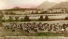
The history of Boonah township is connected to the nearby settlement of Dugandan which was named after a pastoral run of the same name that was taken up in August 1844 by Macquarie McDonald and his brother Campbell Livingstone McDonald.[4][5] Dugandan was one of the earliest pastoral holdings in Queensland.[6] In its early years the area was stocked with sheep but the region was discovered to be well suited for cattle and over time became renowned for the quality of its beef and dairy herds.[7] Adjacent to the property of Dugandan was Coochin Coochin station.[8] In 1873, part of the Coochin Coochin pastoral run was acquired by Frederick Macarthur Bowman who named his property Denelgin. Frederick Bowman took advantage of the suitability of the area for cattle and is considered one of the dairying pioneers of the region.[9]
Variously known as Dugandan Scrub and Blumbergville, Boonah was also positioned within the boundaries of the early Dugandan property. Following the introduction of the Crown Lands Alienation Act of 1868 and the subdivision of the large pastoral runs, the settlement fell within the boundaries of a new 320 acre property acquired by John Hooper in 1878.[10]
Due to the scattered distribution of European settlers, the close proximity of the two settlements that would eventually become the townships of Dugandan and Boonah and the lack of a clear geographical centre, during the 1870s - 1880s the names Dugandan, Blumbergville and Boonah were used interchangeably.[11] As late as 1888, the courts of petty sessions were described as occurring at "Boonah, otherwise known as Blumbergville".[12]
The Dugandan Provisional School opened on 15 July 1878 [13][14] between Dugandan Scrub and Dugandan Flats next to the Teviot Brook on land which would eventually fall within the boundaries of the Blumbergville/Boonah township.[15] The school was the first building in the township [16] and by 1880, 40 families were living in the Dugandan Scrub area and Blumbergville [8] was starting to be established.
Blumbergville took its name from a store owned by three brothers, Max, Levi and Adolf Blumberg, located on the later site of the Commercial Hotel in High Street, Boonah.[17][18][19] Around 1884, the Blumbergville Post Office was opened[20] and on 30 May 1887 the Dugandan Provisional School was upgraded to State School status.[14]
In 1887, the railway line from Ipswich was extended to the area,[21] with the name Boonah given to a rail siding at Blumbergville[5] located one stop before the terminus at the settlement of nearby Dugandan.[17][22] The railway siding took its name from an Aboriginal word from the Yuggera and Yugumbir language groups meaning bloodwood tree (Eucalyptus Corymbosa) or Brigalow tree (Acacia harpadhylla).[23][24]
The local government, the Goolman Division, had its office in Flinders, but the coming of the railway to Boonah resulted in the relocation of the Goolman Division to Boonah in 1888.[8]
Following devastating floods in 1887,[25] the main commercial interests for the district relocated from the lower lying Dugandan, near the railway terminus, to the higher ground of Boonah.[26] The Post Office was renamed Boonah around 1888[20] and in 1895 the school changed its name from Dugandan to Boonah State School.[14][27]

By the end of 1900, the Fassifern Butter Factory owned by Mr. S. Dover was operating in Church Street.[28][29] On 5 July 1916 a larger factory, known as the Boonah Butter Factory, was officially opened on a new site on the northern entry to the town.[30]
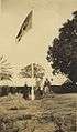
The Goolman Shire War Memorial was unveiled in Boonah (then part of the Goolman Shire) on 19 May 1920 by General Birdwood and Councillor Alexander John Tait McKay. It is generally known as the Boonah War Memorial.[31]
Initially only a primary school, Boonah State School had a secondary class added in February 1955, which it retained until 25 January 1965 when Boonah State High School opened.[13][14][32] Boonah was the centre of the Shire of Boonah local government area until council amalgamations occurred in 2008.
Heritage listings
Boonah has a number of heritage-listed sites, including:
- 8-10 Church Street: Christ Church [33]
- Cossart Street and Macquarie Street: Boonah Showgrounds [33]
- 32 High Street: Australian Hotel [33]
- 39 High Street and Yeates Avenue: Commercial Hotel [33]
- J Bell Road: Coochin Coochin Homestead[34]
- Park Street: Boonah War Memorial and Memorial Park[35]
- 8 Railway Street: former offices of the Qld Farmers Co-operative Association Boonah Butter Factory (now home to Flavour’s Café) [33]
 The Bell family of Coochin Coochin at the property, circa 1920
 Boonah war memorial, 2008
Dams
The Wyaralong Dam was constructed east of Boonah on Teviot Brook, a tributary of the Logan River. At full supply level, water would have inundated parts of the road connecting Boonah and Beaudesert, so a new section of road has been built.[36] Water for the town is supplied from Lake Moogerah on Reynold's Creek, a tributary of the Bremer River. Maroon Dam is another reservoir built 25 kilometres (16 mi) south of Boonah at the base of the McPherson Range.
Climate
Boonah experiences sub-tropical climatic conditions typically with warm wet summers and mild dry winters. Boonah township is approximately 80 metres above sea level. Average annual rainfall for the region is 866 mm, equating to an average of 89 days of rainfall. Temperatures range between daytime averages of mid thirty degrees Celsius in summer, to low twenty degrees Celsius in winter.
Agriculture
The area produces vegetables for the nearby Brisbane Markets notably carrots, potatoes, and cereal crops. Beef, pork and timber are also produced locally. In the 2000/01 financial year the Shire of Boonah produced $67 million worth of agricultural products.[37] More than 135,000 hectares of farmland were used to produce about $20 million worth of crops and $46 million from livestock.[37] Vegetables accounted for more than 20% of agricultural products in the area. The main crops were carrots, French and runner beans, lucerne and potatoes. The shire produced 7% of the state's hay and 8% of the state's soybeans.[38] Dairy cows, meat cattle, meat chicken and pigs were the main livestock commodities, producing 1% of the total value of the state's production in these commodities.[38] Nearly two-thirds of the recorded food and fibre businesses in the Boonah area produced beef cattle. More than 180 farms used irrigation.[37] The town has a local office of Primary Industries and Fisheries.
Media
The town is serviced by the daily newspaper The Queensland Times and the weekly newspaper The Fassifern Guardian.
Education
The Bremer Institute of TAFE had a campus at Boonah, which has operated at limited functionality for several years due to cutbacks. Bremer has since merged into TAFE South Queensland and the Boonah campus has closed.
See also
References
- 1 2 Australian Bureau of Statistics (31 October 2012). "Boonah (Urban Centre/Locality)". 2011 Census QuickStats. Retrieved 17 January 2013.
- ↑ "Boonah (town) (entry 3730)". Queensland Place Names. Queensland Government. Retrieved 28 April 2014.
- ↑ "Boonah (locality) (entry 45116)". Queensland Place Names. Queensland Government. Retrieved 28 April 2014.
- ↑ Cilento, R; Lack, C (1959). "Triumph in the Tropics: An historical sketch of Queensland" (PDF). Queensland Governments Statistician's Office. Queensland Government. Retrieved 30 September 2016.
- 1 2 Queensland Environmental Protection Agency (2000). Heritage Trails of the Great South East. State of Queensland. p. 37. ISBN 0-7345-1008-X.
- ↑ Fox, Matthew J. (1927). "The history of Queensland : its people and industries : an historical and commercial review descriptive and biographical facts, figures and illustrations : an epitome of progress" (PDF). University of Queensland. States Publishing Company. Retrieved 30 September 2016.
- ↑ Fox, Matthew J. (1927). "The history of Queensland : its people and industries : an historical and commercial review descriptive and biographical facts, figures and illustrations : an epitome of progress" (PDF). University of Queensland. States Publishing Company. Retrieved 30 September 2016.
- 1 2 3 "Boonah". Queensland Places. Centre for the Government of Queensland, University of Queensland. Retrieved 28 April 2014.
- ↑ Cilento, R; Lack, C (1959). "Triumph in the Tropics: An historical sketch of Queensland" (PDF). Queensland Governments Statistician's Office. Queensland Government. Retrieved 30 September 2016.
- ↑ Cilento, R; Lack, C (1959). "Triumph in the Tropics: An historical sketch of Queensland" (PDF). Queensland Governments Statistician's Office. Queensland Government. Retrieved 30 September 2016.
- ↑ Jenner, Margeret (1984). "Pioneer life in the Fassifern : Problems and prospects" (PDF). University of Queensland. Retrieved 1 October 2016.
- ↑ "PUBLIC ANNOUNCEMENTS.". Queensland Times, Ipswich Herald And General Advertiser. XXVIII, (4024). Queensland, Australia. 31 March 1888. p. 7. Retrieved 30 September 2016 – via National Library of Australia.
- 1 2 "Opening and closing dates of Queensland Schools". Queensland Government. Retrieved 28 April 2014.
- 1 2 3 4 "Agency ID4991, Boonah State School". Queensland State Archives. Retrieved 28 April 2014.
- ↑ Jenner, Margeret (1984). "Pioneer life in the Fassifern : Problems and prospects" (PDF). University of Queensland. Retrieved 1 October 2016.
- ↑ Jenner, Margeret (1984). "Pioneer life in the Fassifern : Problems and prospects" (PDF). University of Queensland. Retrieved 1 October 2016.
- 1 2 "OPENED 50 YEARS AGO.". Queensland Times. LXXVII, (15,790). Queensland, Australia. 26 June 1937. p. 6 (DAILY.). Retrieved 30 September 2016 – via National Library of Australia.
- ↑ "BLUMBERGVILLE.". Queensland Times, Ipswich Herald And General Advertiser. XXVII, (3729). Queensland, Australia. 4 May 1886. p. 5. Retrieved 30 September 2016 – via National Library of Australia.
- ↑ "Letters to the Editor MORE ON THE ORIGIN OF "BOONAH"". Queensland Times (24,851). Queensland, Australia. 5 November 1953. p. 3 (Daily). Retrieved 30 September 2016 – via National Library of Australia.
- 1 2 Premier Postal History. "Post Office List". Premier Postal Auctions. Retrieved 16 June 2012.
- ↑ A Short History of the Fassifern Branch Line Armstrong, J. Australian Railway Historical Society Bulletin, February 1969 pp. 26—47
- ↑ http://monumentaustralia.org.au/themes/technology/industry/display/90593-fassifern-branch-railway-memorial
- ↑ https://www.dnrm.qld.gov.au/qld/environment/land/place-names/search#/search=boonah&types=0&place=Boonah3730
- ↑ Fox, Matthew J. (1927). "The history of Queensland : its people and industries : an historical and commercial review descriptive and biographical facts, figures and illustrations : an epitome of progress" (PDF). University of Queensland. States Publishing Company. Retrieved 30 September 2016.
- ↑ Jenner, Margeret (1984). "Pioneer life in the Fassifern : Problems and prospects" (PDF). University of Queensland. Retrieved 1 October 2016.
- ↑ "FLOODS RELIEF FUND.". The Brisbane Courier. XLIII, (9,073). Queensland, Australia. 12 February 1887. p. 6. Retrieved 30 September 2016 – via National Library of Australia.
- ↑ "DUGANDAN.". Queensland Times, Ipswich Herald And General Advertiser. XXVIII, (3844). Queensland, Australia. 29 January 1887. p. 3. Retrieved 30 September 2016 – via National Library of Australia.
- ↑ "QUEENSLAND.". The Brisbane Courier. LVI, (13,199). Queensland, Australia. 2 May 1900. p. 5. Retrieved 30 September 2016 – via National Library of Australia.
- ↑ "BUTTER FACTORY FOR BOONAH.". The Queenslander (2052). Queensland, Australia. 8 July 1905. p. 37. Retrieved 30 September 2016 – via National Library of Australia.
- ↑ "BOONAH BUTTER FACTORY.". Queensland Times. LVII, (9591). Queensland, Australia. 6 July 1916. p. 7 (DAILY.). Retrieved 30 September 2016 – via National Library of Australia.
- ↑ "Boonah War Memorial". Monument Australia. Retrieved 4 April 2014.
- ↑ "Agency ID4873, Boonah State High School". Queensland State Archives. Retrieved 28 April 2014.
- 1 2 3 4 5 "Local Heritage Register" (PDF). Scenic Rim Regional Council. Retrieved 9 February 2015.
- ↑ "Coochin Coochin Homestead (entry 600034)". Queensland Heritage Register. Queensland Heritage Council. Retrieved 12 July 2013.
- ↑ "Boonah War Memorial and Memorial Park (entry 600035)". Queensland Heritage Register. Queensland Heritage Council. Retrieved 12 July 2013.
- ↑ Queensland Water Infrastructure Pty Ltd – Wyaralong Dam Project
- 1 2 3 "An overview of food and fibre industries for Boonah and Beaudesert Shires" (PDF). Food and Fibre Futures Project. Department of Primary Industries and Fisheries. March 2007. Retrieved 16 September 2012.
- 1 2 "Regional Agricultural Profile – South East Queensland NRM Region: Agricultural profile of Boonah Shire" (PDF). Derived from the Agricultural Census 2000–01. The State of Queensland. Retrieved 16 September 2012.
External links
![]() Media related to Boonah, Queensland at Wikimedia Commons
Media related to Boonah, Queensland at Wikimedia Commons
| Wikivoyage has a travel guide for Boonah. |
- Dugandan: Queensland Places
- Boonah: Queensland Places
- Dugandan Trinity Lutheran cemetery
- Information about Boonah, Queensland