Greenbank, Queensland
| Greenbank Logan City, Queensland | |||||||||||||
|---|---|---|---|---|---|---|---|---|---|---|---|---|---|
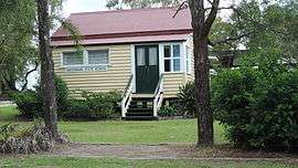 Original Greenbank State School building, 2014 | |||||||||||||
| Population | 7,328 (2011 Census) (2011 census)[1] | ||||||||||||
| Postcode(s) | 4124 | ||||||||||||
| Location | 33 km (21 mi) from Brisbane GPO | ||||||||||||
| LGA(s) | Logan City | ||||||||||||
| State electorate(s) | Logan, Algester, Lockyer | ||||||||||||
| Federal Division(s) | Forde, Rankin | ||||||||||||
| |||||||||||||
Greenbank is a rural-residential suburb within Logan City in Queensland, Australia.[2]
Geography

Once divided between Shire of Beaudesert and Logan City, the Queensland Government's council amalgamations resulted in Greenbank becoming entirely within Logan City, since 15 March 2008.
The suburb is surrounded by farmland and includes the forested Greenbank Military Range, which is a registered Australian Heritage Site. A strip of parkland runs right through the middle of the residential part of Greenbank, on either side of a small watercourse. A bike path, which extends along its length, connects up with neighbouring Boronia Heights.
The size of Greenbank is approximately 49 km². It has 7 parks covering nearly 18% of the total area.
History
The early name of the district was Teviot but derives its present name Greenbank from the name of a cattle property belonging to William Slack.[3]
Greenbank was first settled by Europeans in the 1840s. In the 1880s the main industries were dairying, farming and timber cutting. Cobb and Co had a changing station for their coaches at a hotel on the corner of Teviot Road and Pub Lane; from there, they would travel to Beaudesert via the Old Paradise Road between Acacia Ridge and Jimboomba. When the coach service ceased in 1924, the hotel licence lapsed.[4]
Greenbank Provision School was built by volunteer labour and opened on 23 January 1893 with 12 pupils under teacher Mary Mulroney who received an annual salary of £50.[5][6] It became Greenbank State School in 1909.[7] It closed between 1943 and 1950 due to low student numbers.[4]
Education
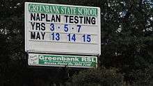
Greenbank State School, a government co-educational primary (P-6) school, is located at 24-36 Goodna Road (27°42′39″S 152°58′39″E / 27.710812°S 152.977376°E).[8] In 2013, the school had an enrolment of 1117 students with 72 teachers (63 full-time equivalent).[9]
Amenities
The Greenbank Community Centre and Library, operated by the Logan City Council, is located at 145-167 Teviot Road (27°43′49″S 152°59′01″E / 27.73040°S 152.98357°E). [10][11]
Sports

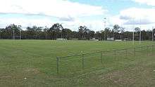
The Greenbank Recreation Reserve is home to the Greenbank Sports & Recreation Club and the Greenbank Raiders Rugby League Club. Situated on Middle Rd (27°43′11″S 152°59′01″E / 27.71971°S 152.98365°E) the rugby club caters for teams from under 6 to under 18 in 2009. Three teams won premierships in 2009. Under 15 division 4, Under 18 division 1 and the very successful under 16 division 2 which completed the year undefeated. They were minor premiers and won the grand final.
Greenbank is also home to the successful Greenbank Football Club. In 2011, the team made history by winning three senior Premierships and two Championships in three divisions. Greenbank FC is affiliated with Football Brisbane and provides an avenue for both junior and senior players. In 2011, Greenbank FC fielded teams from squirts up to under 14 age groups and both men and women teams.
2016 will be Greenbank FC's 40th Year Anniversary.
Demographics
The population of Greenbank in 1996 was 5,098 people. By 2001 the population was 5,261 showing a population growth of 3% in the area during that time. In 2011, the figure had grown to 7,328.[1]
Mostly consisting of acreage blocks close to the Springfield, Queensland, households in Greenbank are primarily couples with children and are likely to be repaying between $800.00 – $1000.00 per month on mortgage repayments. In general, people in Greenbank work in a trades occupation. In 1996, 84% of the homes in Greenbank were owner-occupied compared with 86% in 2001. Currently the median sale price of houses in the area is $395,000.
In the 2011 census, Greenbank recorded a population of 7,328 people, 49.4% female and 50.6% male. The median age of the Greenbank population was 36 years, 1 year below the national median of 37. 75.1% of people living in Greenbank were born in Australia. The other top responses for country of birth were England 5.8%, New Zealand 5.5%, Vietnam 0.9%, Taiwan 0.7%, South Africa 0.6%. 87.6% of people spoke only English at home; the next most common languages were 1.5% Vietnamese, 1.1% Mandarin, 0.6% Hmong, 0.5% Mon-Khmer, 0.5% Spanish.[1]
References
- 1 2 3 Australian Bureau of Statistics (31 October 2012). "Greenbank". 2011 Census QuickStats. Retrieved 27 December 2012.
- ↑ "Greenbank (entry 45266)". Queensland Place Names. Queensland Government. Retrieved 7 May 2014.
- ↑ "News and Notes of General Interest for the Man on the Land.". The Brisbane Courier. National Library of Australia. 4 October 1930. p. 9. Retrieved 8 May 2014.
- 1 2 "Greenbank". Suburbs. Logan City Council. Retrieved 7 May 2014.
- ↑ "Opening and closing dates of Queensland Schools". Queensland Government. Retrieved 7 May 2014.
- ↑ "How old is Greenbank State School?". Greenbank State School. 29 November 2012. Retrieved 18 August 2014.
- ↑ "Agency ID5273, Greenbank State School". Queensland State Archives. Retrieved 7 May 2014.
- ↑ "Queensland State and Non-State Schools". Queensland Government. Retrieved 7 May 2014.
- ↑ "2013 School Annual Report" (PDF). Greenbank State School. Retrieved 18 August 2014.
- ↑ "Greenbank Library". Library locations. Logan City Council. Retrieved 7 May 2014.
- ↑ "Greenbank Community Centre". Community centres. Logan City Council. Retrieved 7 May 2014.
Further reading
- Scott, Joanne; Greenbank State School (1993), Greenbank State School centenary book : including New Beith, North Maclean and Maclean schools, Greenbank State School, ISBN 978-0-646-14341-5
External links
| Wikimedia Commons has media related to Greenbank, Queensland. |
- University of Queensland: Queensland Places: Greenbank
- "News and Notes of General Interest for the Man on the Land.". The Brisbane Courier. National Library of Australia. 4 October 1930. — a description of Greenbank in 1930
Coordinates: 27°41′S 152°59′E / 27.683°S 152.983°E