Rathdowney, Queensland
| Rathdowney Queensland | |
|---|---|
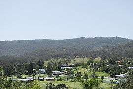 Rathdowney seen from the town's scenic lookout | |
 Rathdowney | |
| Coordinates | 28°12′0″S 152°51′0″E / 28.20000°S 152.85000°ECoordinates: 28°12′0″S 152°51′0″E / 28.20000°S 152.85000°E |
| Population | 434 (2011 census)[1] |
| Postcode(s) | 4287 |
| LGA(s) | Scenic Rim Region |
| State electorate(s) | Beaudesert |
| Federal Division(s) | Forde |
Rathdowney is a small town in south-eastern Queensland, Australia. It is on the Mount Lindesay Highway 32 kilometres (20 mi) south of Beaudesert at the base of the McPherson Range. It is located in the Scenic Rim local government area. At the 2011 census, Rathdowney had a population of 434.[1]
History
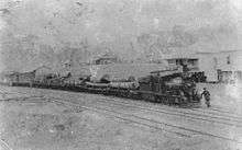
The town was named after the former Rathdowney station,[2] which derived its name from Rathdowney in Ireland. The Beaudesert Shire Tramway was extended to Rathdowney in 1911 but closed in 1944.[3] Timber clearing was the first major industry in the area. Cattle grazing and dairy farming are now the main industries.
Heritage listings
Rathdowney has the following heritage-listed sites:
- 8-12 Hardgrave Street and 14-18 Prior Street: St David’s Church of England [4]
- 157-159 Mount Lindesay Highway: St Joseph’s Catholic Church [4]
Geography
The eastern boundary is marked by the Logan River. It is also close to some of the areas of greatest biodiversity in Australia, and a gateway to various National Parks such as Border Ranges National Park and Mount Barney National Park with a variety of lush rainforest, eucalypt forest, mountain heath and other habitats. In the west, where Burnetts Creek enters the Logan is Bigriggen Reserve Park. The park provides camp sites with a kiosk by the river with access available to caravans, motorhomes and buses.[5]
Attractions
There are many tours, farm stays, guest houses and other opportunities available for visitors to experience this region, which is about a 90-minute drive from Brisbane or the Gold Coast. In Autumn every year the population rises by several thousand for one day at the Rathdowney Heritage Festival, organised by the Rathdowney and District Historical Association (RADHA), who also run an information centre with information on natural heritage, indigenous heritage and history of white settlement from the time of the first pioneers to present day.
Mount Maroon is 12 km west of Rathdowney. At 966 m the summit provides 360 degree views.[6]
Amenities
Currently the small town has a police station, a small shop, a pub, a service station, a post office, memorial grounds, information centre, a bowls club and a small school. The Rathdowney Primary School has a 25 m swimming pool in which every spring and summer the swimming club has races on a Friday night. The swimming club also has swimming training during the week after school.
See also
References
- 1 2 Australian Bureau of Statistics (31 October 2012). "Rathdowney (State Suburb)". 2011 Census QuickStats. Retrieved 12 July 2013.
- ↑ "For the man on the land.". The Brisbane Courier (22,296). Queensland, Australia. 13 July 1929. p. 11. Retrieved 28 March 2016 – via National Library of Australia.
- ↑ Queensland Environmental Protection Agency (2000). Heritage Trails of the Great South East. State of Queensland. p. 31. ISBN 0-7345-1008-X.
- 1 2 "Local Heritage Register" (PDF). Scenic Rim Regional Council. Retrieved 9 February 2015.
- ↑ "Welcome To Bigriggen Park in the Scenic Rim". Retrieved 28 March 2016.
- ↑ "Mt Maroon - Aussie Bushwalking". Aussie Bushwalking. Retrieved 28 March 2016.
External links
![]() Media related to Rathdowney, Queensland at Wikimedia Commons
Media related to Rathdowney, Queensland at Wikimedia Commons