Scenic Rim

The Scenic Rim is a group of forested mountain ranges of the Great Dividing Range straddling the border between south-eastern Queensland and north-eastern New South Wales, Australia.
Description
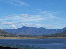
The mountainous landscape forms a quarter circle ridge positioned roughly from south of Toowoomba around to Springbrook. Tamborine Mountain, Lever's Plateau and the Lamington Plateau are part of the rim formation.[1] The scenic rim is considered part of the Gold Coast hinterland. Parts of the rim are well developed, crossed by highways with facilities for tourists like Cunninghams Gap, others are privately owned agricultural properties and rural villages such as Beechmont and Tamborine Mountain. Much of the rest is protected in national parks and nature reserves.
Ranges

The ranges include the Little Liverpool Range, Main Range, Mistake Ranges, McPherson Range, Teviot Range and the Tweed Range. Valleys of the Scenic Rim include Laidley Creek, Christmas Creek, Lockyer Valley, Fassifern Valley, Numinbah Valley, the Albert River, Logan River, Coomera River and the Bremer River.
Environment
The geology and landscape of the Scenic Rim is largely volcanic in origin, deriving from the prehistoric Tweed Volcano, including the Mount Warning shield volcano, and the Focal Peak and Main Range volcanic rocks. Some areas of sedimentary origin include parts of Mount Barney and eastern Lamington national parks. The deeply weathered, mainly basaltic, soils support rainforest and vine thicket ecosystems, as well as rare eucalypt and grassland communities. The area has a subtropical climate with (at the lowest altitudes) average minimum winter temperatures of 6°C, average maximum summer temperatures of 29°C, and average annual rainfall of 1555 mm.[2]
Protected areas

Areas protected in national parks and other conservation reserves include the Border Ranges National Park, Glen Rock Regional Park, Koreelah National Park, Lamington National Park, Limpinwood Nature Reserve, Main Range National Park, Mebbin National Park, Moogerah Peaks National Park, Mount Barney National Park, Mount Chinghee National Park, Mount Clunie National Park, Mount Nothofagus National Park, Mount Warning National Park, Numinbah Nature Reserve and Springbrook National Park. Parts of the Scenic Rim are listed as a World Heritage site, and some are designated Wilderness Areas.[2]
Important Bird Area
A 1351 km2 area encompassing the Scenic Rim has been identified by BirdLife International as an Important Bird Area (IBA) because it supports populations of endangered eastern bristlebirds, black-breasted button-quails, rufous scrub-birds, Albert's lyrebirds, pale-yellow robins, paradise riflebirds, green catbirds, regent bowerbirds and Australian logrunners.[3] There are also historical and recent sight records of the critically endangered Coxen's fig parrot.[2]
Tourism
There are many recreational activities for day-trippers, rockclimbers, hikers and nature lovers on the ranges. The concept of the Scenic Rim was first described by Arthur Groom and Romeo Lahey in the 1920s.[4] They were campaigning for the protection of the forests from Main Range to the Lamington Plateau. At about the same time the Binna Burra lodge and O'Reilly's Guesthouse were established as the popularity of the area grew with tourists.
See also
References
- ↑ Rankin, Robert. (1992) Secrets of the Scenic Rim. Rankin Publishers ISBN 0-9592418-3-3
- 1 2 3 BirdLife International. (2011). Important Bird Areas factsheet: Scenic Rim. Downloaded from http://www.birdlife.org on 2011-10-03.
- ↑ "IBA: Scenic Rim". Birdata. Birds Australia. Retrieved 2011-10-03.
- ↑ Queensland Environmental Protection Agency (2000). Heritage Trails of the Great South East. State of Queensland. p. 18. ISBN 0-7345-1008-X.
External links
Coordinates: 28°07′22″S 153°11′22″E / 28.12278°S 153.18944°E