Mason County, West Virginia
| Mason County, West Virginia | |
|---|---|
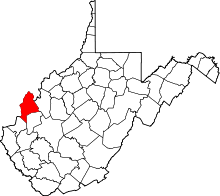 Location in the U.S. state of West Virginia | |
 West Virginia's location in the U.S. | |
| Founded | January 2, 1804 |
| Seat | Point Pleasant |
| Largest city | Point Pleasant |
| Area | |
| • Total | 445 sq mi (1,153 km2) |
| • Land | 431 sq mi (1,116 km2) |
| • Water | 14 sq mi (36 km2), 3.1% |
| Population (est.) | |
| • (2015) | 27,037 |
| • Density | 63/sq mi (24/km²) |
| Congressional district | 3rd |
| Time zone | Eastern: UTC-5/-4 |
| Website |
www |
Mason County is a county located in the U.S. state of West Virginia. As of the 2010 census, the population was 27,324.[1] Its county seat is Point Pleasant.[2] The county was founded in 1804 and was named for George Mason,[3] delegate to the U.S. Constitutional Convention. Before the Civil War, the county was located in the State of Virginia.
Mason County is part of the Point Pleasant, WV-OH Micropolitan Statistical Area.
History
In the second half of 1749, the French explorer, Pierre Joseph Céloron de Blainville, claimed French sovereignty over the Ohio Valley, burying a lead plaque at the meeting point of the Ohio and Kanawha Rivers, naming the place Point Pleasant.
In the Battle of Point Pleasant (October 10, 1774), fought on the future site of the town, over one thousand Virginia militiamen, led by Colonel Andrew Lewis (1720–1781), defeated a roughly equal force of an Algonquin confederation of Shawnee and Mingo warriors led by Shawnee Chief Cornstalk (ca. 1720-1777). The event is celebrated locally as the "First Battle of the American Revolutionary War" and in 1908 the U.S. Senate authorized erection of a local monument to commemorate it as such. Most historians, however, regard it not as a battle of the Revolution (1775–1783), but as a part of Lord Dunmore's War (1774). "Camp Point Pleasant" was established by Col. Lewis at the time of the Battle and the settlement that followed also took that name. Although not certain, Point Pleasant may have been permanently settled by whites as early as 1774.
According to Hardesty's West Virginia Counties (1883), regarding the first white settlers in Mason County south of Point Pleasant:
All that part of the district lying on the Ohio river bottoms above Eighteen-mile Creek, was included in the grant made by Congress to the heirs of General Mercer, who was killed at the battle of Princeton, New Jersey, January 3, 1777, while fighting by the side of Washington; hence the name Mercer Bottom. Who located and surveyed the lands cannot now be learned, but his grandson, Charles Fenton Mercer, of Virginia, afterward put the lands in market and sold them in quantities to suit purchasers. Thomas Hannan, whose name is preserved in that of the district, was the first actual settler - locating in the year 1790. Andrew Fleming and a Mr. Mercer, two hunters, had previously erected a cabin on the land which he purchased, and this was occupied by him until he could build a better one. Soon Jesse George purchased seventy acres of land at the mouth of Flatfoot Creek ... and became the second actual settler. Then came John Hereford, Robert Hereford, Thomas Powell, Edward S. Menager, John Morris — who discovered the first salt water on Kanawha river — George Withers, Robert Cremeans, James George, Rev. John Canterbury ...
The settlement at Point Pleasant did not receive an official charter until 1794. The first road through what later became Mason County was laid out by Thomas Hannan (1757-1835) in 1798 under contract to the federal government. It traversed the distance from present-day St Albans, [West] Virginia to Chillicothe, Ohio. This road (parts are still known as "Hannan Trace Road") is one of the oldest roads in Ohio. It became a main highway connecting Chillicothe and points east during the time when that settlement served as the capital of the Northwest Territory and the first capital of Ohio.
Mason County was officially created, from Kanawha County, on January 2, 1804. It was named for George Mason IV (1725–1792), known as the "Father of the United States Bill of Rights" and a Founding Father of the United States. By 1810, the total county population stood at almost two thousand people.
Geography
According to the U.S. Census Bureau, the county has a total area of 445 square miles (1,150 km2), of which 431 square miles (1,120 km2) is land and 14 square miles (36 km2) (3.1%) is water.[4]
Major highways
 U.S. Highway 35
 West Virginia Route 2
 West Virginia Route 62
 West Virginia Route 87
 West Virginia Route 817
Adjacent counties
- Meigs County, Ohio (north)
- Jackson County (east)
- Putnam County (southeast)
- Cabell County (southwest)
- Gallia County, Ohio (west)
National protected area
Demographics
| Historical population | |||
|---|---|---|---|
| Census | Pop. | %± | |
| 1810 | 1,991 | — | |
| 1820 | 4,868 | 144.5% | |
| 1830 | 6,534 | 34.2% | |
| 1840 | 6,777 | 3.7% | |
| 1850 | 7,539 | 11.2% | |
| 1860 | 9,173 | 21.7% | |
| 1870 | 15,978 | 74.2% | |
| 1880 | 22,293 | 39.5% | |
| 1890 | 22,863 | 2.6% | |
| 1900 | 24,142 | 5.6% | |
| 1910 | 23,019 | −4.7% | |
| 1920 | 21,459 | −6.8% | |
| 1930 | 20,788 | −3.1% | |
| 1940 | 22,270 | 7.1% | |
| 1950 | 23,537 | 5.7% | |
| 1960 | 24,459 | 3.9% | |
| 1970 | 24,306 | −0.6% | |
| 1980 | 27,045 | 11.3% | |
| 1990 | 25,178 | −6.9% | |
| 2000 | 25,957 | 3.1% | |
| 2010 | 27,324 | 5.3% | |
| Est. 2015 | 27,037 | [5] | −1.1% |
| U.S. Decennial Census[6] 1790–1960[7] 1900–1990[8] 1990–2000[9] 2010–2015[1] | |||
2000 census
As of the census[10] of 2000, there were 25,957 people, 10,587 households, and 7,569 families residing in the county. The population density was 60 people per square mile (23/km²). There were 12,056 housing units at an average density of 28 per square mile (11/km²). The racial makeup of the county was 98.37% White, 0.50% Black or African American, 0.18% Native American, 0.27% Asian, 0.01% Pacific Islander, 0.11% from other races, and 0.56% from two or more races. 0.47% of the population were Hispanic or Latino of any race.
There were 10,587 households out of which 30.60% had children under the age of 18 living with them, 57.60% were married couples living together, 10.10% had a female householder with no husband present, and 28.50% were non-families. 25.50% of all households were made up of individuals and 11.50% had someone living alone who was 65 years of age or older. The average household size was 2.42 and the average family size was 2.89.
In the county, the population was spread out with 22.70% under the age of 18, 8.30% from 18 to 24, 27.70% from 25 to 44, 26.10% from 45 to 64, and 15.20% who were 65 years of age or older. The median age was 40 years. For every 100 females there were 96.20 males. For every 100 females age 18 and over, there were 92.10 males.
The median income for a household in the county was $27,134, and the median income for a family was $32,953. Males had a median income of $32,382 versus $17,074 for females. The per capita income for the county was $14,804. About 16.60% of families and 19.90% of the population were below the poverty line, including 27.30% of those under age 18 and 14.50% of those age 65 or over.
2010 census
As of the 2010 United States Census, there were 27,324 people, 11,149 households, and 7,649 families residing in the county.[11] The population density was 63.4 inhabitants per square mile (24.5/km2). There were 13,006 housing units at an average density of 30.2 per square mile (11.7/km2).[12] The racial makeup of the county was 97.7% white, 0.6% black or African American, 0.3% Asian, 0.2% American Indian, 0.1% from other races, and 1.0% from two or more races. Those of Hispanic or Latino origin made up 0.4% of the population.[11] In terms of ancestry, 19.4% were German, 11.3% were Irish, 11.2% were American, and 7.6% were English.[13]
Of the 11,149 households, 29.8% had children under the age of 18 living with them, 52.5% were married couples living together, 11.6% had a female householder with no husband present, 31.4% were non-families, and 27.4% of all households were made up of individuals. The average household size was 2.39 and the average family size was 2.89. The median age was 42.4 years.[11]
The median income for a household in the county was $36,027 and the median income for a family was $42,054. Males had a median income of $41,607 versus $25,444 for females. The per capita income for the county was $19,609. About 14.6% of families and 18.9% of the population were below the poverty line, including 27.3% of those under age 18 and 10.2% of those age 65 or over.[14]
Politics
| Year | Republican | Democrat |
|---|---|---|
| 2016 | 74.49% 7,597 | 20.29% 2,069 |
| 2012 | 58.64% 5,741 | 38.59% 3,778 |
| 2008 | 55.20% 5,853 | 42.29% 4,484 |
| 2004 | 54.10% 6,487 | 45.10% 5,408 |
| 2000 | 53.21% 5,972 | 44.22% 4,963 |
Education

There are 3 junior/senior high schools, 7 elementary schools and 1 primary school in Mason County.
- Point Pleasant Primary School
- Ashton Elemenrary School
- Beale Elementary School
- Leon Elementary School
- Mason Elementary School
- Point Pleasant Intermediate School
- Roosevelt Elementary School
- Hannan Junior/Senior High School
- Point Pleasant Junior/Senior High School
- Wahama Junior/Senior High School
- New Haven Elementary School
The superintendent of Mason County schools is Suzanne Dickens.
Mason County Fair
The Mason County Fair, held at the Mason County Fair Grounds in Point Pleasant, is the largest county fair in West Virginia (in terms of attendance). It is held every year during the first week of August.
Communities
City
- Point Pleasant (county seat)
Towns
Census-designated places
Unincorporated communities
Notable natives and residents
See also
- Chief Cornstalk Wildlife Management Area
- County (United States)
- Green Bottom Wildlife Management Area
- Kanawha River
- National Register of Historic Places listings in Mason County, West Virginia
- Ohio River
- Tu-Endie-Wei State Park
References
- 1 2 "State & County QuickFacts". United States Census Bureau. Retrieved January 10, 2014.
- ↑ "Find a County". National Association of Counties. Retrieved 2011-06-07.
- ↑ "Mason County history sources". Wvculture.org. Retrieved 2013-12-27.
- ↑ "2010 Census Gazetteer Files". United States Census Bureau. August 22, 2012. Retrieved July 30, 2015.
- ↑ "County Totals Dataset: Population, Population Change and Estimated Components of Population Change: April 1, 2010 to July 1, 2015". Retrieved July 2, 2016.
- ↑ "U.S. Decennial Census". United States Census Bureau. Retrieved January 10, 2014.
- ↑ "Historical Census Browser". University of Virginia Library. Retrieved January 10, 2014.
- ↑ "Population of Counties by Decennial Census: 1900 to 1990". United States Census Bureau. Retrieved January 10, 2014.
- ↑ "Census 2000 PHC-T-4. Ranking Tables for Counties: 1990 and 2000" (PDF). United States Census Bureau. Retrieved January 10, 2014.
- ↑ "American FactFinder". United States Census Bureau. Retrieved 2011-05-14.
- 1 2 3 "DP-1 Profile of General Population and Housing Characteristics: 2010 Demographic Profile Data". United States Census Bureau. Retrieved 2016-04-03.
- ↑ "Population, Housing Units, Area, and Density: 2010 - County". United States Census Bureau. Retrieved 2016-04-03.
- ↑ "DP02 SELECTED SOCIAL CHARACTERISTICS IN THE UNITED STATES – 2006-2010 American Community Survey 5-Year Estimates". United States Census Bureau. Retrieved 2016-04-03.
- ↑ "DP03 SELECTED ECONOMIC CHARACTERISTICS – 2006-2010 American Community Survey 5-Year Estimates". United States Census Bureau. Retrieved 2016-04-03.
- ↑ "Dave Leip's Atlas of U.S. Presidential Elections". Retrieved 2016-11-18.
External links
| Wikimedia Commons has media related to Mason County, West Virginia. |
- Mason County Convention and Visitors Bureau
- Mason County Area Chamber of Commerce
- City of Point Pleasant
- Point Pleasant Internet Directory
- The Point Pleasant Register
- Mason County Fair
 |
Meigs County, Ohio | | ||
| Gallia County, Ohio | |
Jackson County | ||
| ||||
| | ||||
| Cabell County | Putnam County |
Coordinates: 38°46′N 82°01′W / 38.77°N 82.02°W