Summers County, West Virginia
| Summers County, West Virginia | ||
|---|---|---|
 The Summers County Courthouse in Hinton | ||
| ||
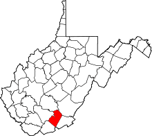 Location in the U.S. state of West Virginia | ||
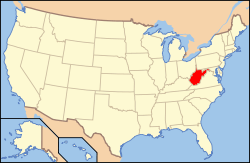 West Virginia's location in the U.S. | ||
| Founded | February 27, 1871 | |
| Named for | George W. Summers | |
| Seat | Hinton | |
| Largest city | Hinton | |
| Area | ||
| • Total | 368 sq mi (953 km2) | |
| • Land | 360 sq mi (932 km2) | |
| • Water | 7.3 sq mi (19 km2), 2.0% | |
| Population (est.) | ||
| • (2015) | 13,239 | |
| • Density | 37/sq mi (14/km²) | |
| Congressional district | 3rd | |
| Time zone | Eastern: UTC-5/-4 | |
| Website |
summerscountywv | |

Summers County is a county located in the U.S. state of West Virginia. As of the 2010 census, the population was 13,927.[1] Its county seat is Hinton.[2] The county was created by an act of the West Virginia Legislature on February 27, 1871 from parts of Fayette, Greenbrier, Mercer and Monroe counties and named in honor of George W. Summers (1804-1868).[3]
Geography
According to the U.S. Census Bureau, the county has a total area of 368 square miles (950 km2), of which 360 square miles (930 km2) is land and 7.3 square miles (19 km2) (2.0%) is water.[4]
Major highways
 Interstate 64
 West Virginia Route 3
 West Virginia Route 12
 West Virginia Route 20
 West Virginia Route 107
Adjacent counties
- Greenbrier County (northeast)
- Monroe County (east)
- Mercer County (southwest)
- Raleigh County (west)
- Fayette County (northwest)
- Giles County, Virginia (south)
National protected areas
Demographics
| Historical population | |||
|---|---|---|---|
| Census | Pop. | %± | |
| 1880 | 9,033 | — | |
| 1890 | 13,117 | 45.2% | |
| 1900 | 16,265 | 24.0% | |
| 1910 | 18,429 | 13.3% | |
| 1920 | 19,092 | 3.6% | |
| 1930 | 20,469 | 7.2% | |
| 1940 | 20,409 | −0.3% | |
| 1950 | 19,183 | −6.0% | |
| 1960 | 15,640 | −18.5% | |
| 1970 | 13,213 | −15.5% | |
| 1980 | 15,875 | 20.1% | |
| 1990 | 14,204 | −10.5% | |
| 2000 | 12,999 | −8.5% | |
| 2010 | 13,927 | 7.1% | |
| Est. 2015 | 13,239 | [5] | −4.9% |
| U.S. Decennial Census[6] 1790–1960[7] 1900–1990[8] 1990–2000[9] 2010–2015[1] | |||
2000 census
As of the census[10] of 2000, there were 12,999 people, 5,530 households, and 3,754 families residing in the county. The population density was 36 people per square mile (14/km²). There were 7,331 housing units at an average density of 20 per square mile (8/km²). The racial makeup of the county was 96.57% White, 2.15% Black or African American, 0.25% Native American, 0.09% Asian, 0.04% Pacific Islander, 0.10% from other races, and 0.79% from two or more races. 0.55% of the population were Hispanic or Latino of any race.
There were 5,530 households out of which 25.70% had children under the age of 18 living with them, 53.80% were married couples living together, 10.00% had a female householder with no husband present, and 32.10% were non-families. 29.10% of all households were made up of individuals and 14.40% had someone living alone who was 65 years of age or older. The average household size was 2.32 and the average family size was 2.84.
In the county, the population was spread out with 20.50% under the age of 18, 7.50% from 18 to 24, 24.70% from 25 to 44, 27.30% from 45 to 64, and 19.90% who were 65 years of age or older. The median age was 43 years. For every 100 females there were 95.60 males. For every 100 females age 18 and over, there were 93.00 males.
The median income for a household in the county was $21,147, and the median income for a family was $27,251. Males had a median income of $27,485 versus $18,491 for females. The per capita income for the county was $12,419. 24.40% of the population and 20.30% of families were below the poverty line. Out of the total population, 34.30% of those under the age of 18 and 14.50% of those 65 and older were living below the poverty line.
2010 census
As of the 2010 United States Census, there were 13,927 people, 5,572 households, and 3,632 families residing in the county.[11] The population density was 38.6 inhabitants per square mile (14.9/km2). There were 7,680 housing units at an average density of 21.3 per square mile (8.2/km2).[12] The racial makeup of the county was 93.0% white, 4.8% black or African American, 0.3% American Indian, 0.2% Asian, 0.4% from other races, and 1.3% from two or more races. Those of Hispanic or Latino origin made up 1.4% of the population.[11] In terms of ancestry, 20.2% were Irish, 18.2% were German, 17.1% were English, and 10.2% were American.[13]
Of the 5,572 households, 24.5% had children under the age of 18 living with them, 48.8% were married couples living together, 10.9% had a female householder with no husband present, 34.8% were non-families, and 30.8% of all households were made up of individuals. The average household size was 2.26 and the average family size was 2.79. The median age was 45.7 years.[11]
The median income for a household in the county was $27,720 and the median income for a family was $39,235. Males had a median income of $27,382 versus $25,011 for females. The per capita income for the county was $15,190. About 15.6% of families and 21.6% of the population were below the poverty line, including 23.4% of those under age 18 and 18.8% of those age 65 or over.[14]
Politics
| Year | Republican | Democrat |
|---|---|---|
| 2016 | 70.60% 3,444 | 24.31% 1,186 |
| 2012 | 62.84% 2,981 | 34.17% 1,621 |
| 2008 | 54.38% 2,891 | 43.08% 2,290 |
| 2004 | 53.91% 2,978 | 45.33% 2,504 |
| 2000 | 48.89% 2,304 | 48.78% 2,299 |
Government and infrastructure

The Federal Bureau of Prisons Federal Prison Camp, Alderson is partly in unincorporated Monroe County and partly in unincorporated Summers County.[16][17]
Education
Public schools in Summers County are governed by the Summers County Schools school district; per West Virginia state law, all school districts in West Virginia follow county boundaries.[18] 1,548 students are enrolled in the five public schools in Summers County.[19] Summers County has one public high school, Summers County High School, which serves students in grades 9-12; one middle school, Summers Middle School, which serves students in grades 5-8; and three elementary schools, Hinton Area Elementary School, serving Pre-K through 4th grades, and Jumping Branch Elementary School and Talcott Elementary School which serve students in grades Pre-K through 5.[19] Summers County High School has a total enrollment of 458 students and a graduation rate of 78.45%[20] Summers Middle School has an enrollment of 334 students, and Hinton Area Elementary School, Jumping Branch Elementary School, and Talcott Elementary School have enrollments of 469, 132, and 155 students respectively.[21][22][23][24]
Summers County is also home to one private school, Pipestem Christian Academy.[25][26] Pipestem Christian Academy is part of the West Virginia Christian Education Association and has a total enrollment of 89 students in grades Pre-K through 11.[27][28] Greenbrier Academy, a therapeutic boarding school for girls, is also located in Summers County, in the community of Pence Springs.[29] Additionally, 28 home schools serving 38 students are located in Summers County.[25][28]
Communities
City
- Hinton (county seat)
Other places
See also
References
- 1 2 "State & County QuickFacts". United States Census Bureau. Retrieved January 11, 2014.
- ↑ "Find a County". National Association of Counties. Retrieved 2011-06-07.
- ↑ http://www.polsci.wvu.edu/wv/history.html
- ↑ "2010 Census Gazetteer Files". United States Census Bureau. August 22, 2012. Retrieved July 30, 2015.
- ↑ "County Totals Dataset: Population, Population Change and Estimated Components of Population Change: April 1, 2010 to July 1, 2015". Retrieved July 2, 2016.
- ↑ "U.S. Decennial Census". United States Census Bureau. Retrieved January 11, 2014.
- ↑ "Historical Census Browser". University of Virginia Library. Retrieved January 11, 2014.
- ↑ "Population of Counties by Decennial Census: 1900 to 1990". United States Census Bureau. Retrieved January 11, 2014.
- ↑ "Census 2000 PHC-T-4. Ranking Tables for Counties: 1990 and 2000" (PDF). United States Census Bureau. Retrieved January 11, 2014.
- ↑ "American FactFinder". United States Census Bureau. Retrieved 2011-05-14.
- 1 2 3 "DP-1 Profile of General Population and Housing Characteristics: 2010 Demographic Profile Data". United States Census Bureau. Retrieved 2016-04-03.
- ↑ "Population, Housing Units, Area, and Density: 2010 - County". United States Census Bureau. Retrieved 2016-04-03.
- ↑ "DP02 SELECTED SOCIAL CHARACTERISTICS IN THE UNITED STATES – 2006-2010 American Community Survey 5-Year Estimates". United States Census Bureau. Retrieved 2016-04-03.
- ↑ "DP03 SELECTED ECONOMIC CHARACTERISTICS – 2006-2010 American Community Survey 5-Year Estimates". United States Census Bureau. Retrieved 2016-04-03.
- ↑ "Dave Leip's Atlas of U.S. Presidential Elections". Retrieved 2016-11-18.
- ↑ "Martha's Prison Thanksgiving." The Cincinnati Post. November 24, 2004. Retrieved on January 5, 2010. "Mullins said the prison dormitories are in Summers County."
- ↑ "FPC Alderson Contact Information." Federal Bureau of Prisons. Retrieved on January 5, 2010.
- ↑ "West Virginia Code §18-1-3". West Virginia Legislature. Retrieved June 7, 2010.
- 1 2 "School District Profile - Summers County". West Virginia Department of Education. Retrieved June 7, 2010.
- ↑ "Summers County High School Profile". West Virginia Department of Education. Retrieved June 7, 2010.
- ↑ "Summers Middle School Profile". West Virginia Department of Education. Retrieved June 7, 2010.
- ↑ "Hinton Area Elementary School Profile". West Virginia Department of Education. Retrieved June 7, 2010.
- ↑ "Jumping Branch Elementary School Profile". West Virginia Department of Education. Retrieved June 7, 2010.
- ↑ "Talcott Elementary School Profile". West Virginia Department of Education. Retrieved June 7, 2010.
- 1 2 "Number of Non-Public Schools in West Virginia by County". West Virginia Department of Education. 2008–2009. Retrieved June 2, 2010.
- ↑ "Summers County Private Schools". Private School Review. Retrieved June 2, 2010.
- ↑ "WVCEA Member Schools". West Virginia Christian Education Association. Retrieved June 2, 2010.
- 1 2 "Enrollment in Non-Public Schools". West Virginia Department of Education. Retrieved June 2, 2010.
- ↑ "Greenbrier Academy Home Page". Greenbrier Academy. Retrieved June 2, 2010.
 |
Fayette County | Greenbrier County | | |
| Raleigh County | |
Monroe County | ||
| ||||
| | ||||
| Mercer County | Giles County, Virginia |
Municipalities and communities of Summers County, West Virginia, United States | ||
|---|---|---|
| City | | |
| Unincorporated communities |
| |
| Ghost towns | ||
| Footnotes | ‡This populated place also has portions in an adjacent county or counties | |
Coordinates: 37°40′N 80°52′W / 37.66°N 80.86°W