Pocahontas County, West Virginia
| Pocahontas County, West Virginia | |
|---|---|
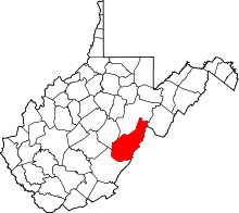 Location in the U.S. state of West Virginia | |
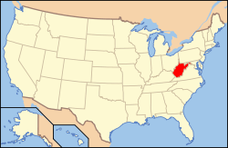 West Virginia's location in the U.S. | |
| Founded | December 21, 1821 |
| Named for | Pocahontas |
| Seat | Marlinton |
| Largest town | Marlinton |
| Area | |
| • Total | 942 sq mi (2,440 km2) |
| • Land | 940 sq mi (2,435 km2) |
| • Water | 1.5 sq mi (4 km2), 0.2% |
| Population (est.) | |
| • (2015) | 8,607 |
| • Density | 9.2/sq mi (4/km²) |
| Congressional district | 3rd |
| Time zone | Eastern: UTC-5/-4 |
| Website |
www |
Pocahontas County is a county located in the U.S. state of West Virginia. As of the 2010 census, the population was 8,719.[1] Its county seat is Marlinton.[2] The county was established in 1821 and is named after the Native American chief's daughter from Jamestown, Virginia.[3]
Pocahontas County is the home to the National Radio Astronomy Observatory Green Bank Telescope and is part of the National Radio Quiet Zone.
History
When Andrew Lewis, early American pioneer, soldier, surveyor, and soldier from Virginia, came to survey one of the land grants for the Greenbrier Company in 1751, he found Jacob Marlin and Stephen Sewell living where Marlinton is found today. They had come from Frederick, Maryland, in 1749 and are considered the first settlers west of the Alleghenies. They built their original cabin where Marlin Run met Knapp’s Creek but Lewis found Sewell living in a large hollow sycamore tree near the cabin in what is now the area between Eighth and Ninth Avenues between Eighth and Ninth Streets.
The move Westward by settlers was not met well by the Indians as this was one of their many favored hunting areas. A treaty of 1758 confirmed the land west of the Allegheny Mountains to the Indians and forbidding any of his Majesty’s subjects to settle or hunt.
As the white settlers encroached onto the Indian land, there were many raids and massacres reported. After the Revolution, the Indian squabbles quieted and the settlers’ land claims were secured in an orderly manner.
In June 1863, West Virginia became the 35th state of the Union. Although part of Virginia at the time, the two areas differed culturally and pioneering individuals traditionally settled the western portion, while a slave-holding aristocratic society developed in the eastern portion. When Virginia seceded from the Union in 1861, the residents of the western counties, few of whom owned slaves, decided to stay with the Union. For West Virginia it truly was a Civil War.
The railroads came late to Pocahontas County as building rails over the mountains was not only a tedious job, but an expensive job. It was not until 1899 that construction began but after that, the task moved with startling speed. The 1900 census of the county indicates that many Europeans came to the region to build the railroads.
Commercial timbering quickly began upon completion of the railroads, including a large mill owned by the West Virginia Pulp & Paper Company (now MeadWestvaco) at Cass. By the end of 1920, dozens of small railroading towns dotted the landscape along the Chesapeake & Ohio Railway line.[4]
Geography
According to the U.S. Census Bureau, the county has a total area of 942 square miles (2,440 km2), of which 940 square miles (2,400 km2) is land and 1.5 square miles (3.9 km2) (0.2%) is water.[5] It is the third-largest county in West Virginia by area.
The highest point is Thorny Flat on Cheat Mountain in the northwestern part of the county, elevation 4848 feet (1478 m).[6]
Birthplace of rivers
The county is the site of the headwaters for eight rivers: Cherry River, Cranberry River, Elk River, Gauley River, Greenbrier River, Tygart Valley River, Williams River, and Shavers Fork of the Cheat River. The Monongahela National Forest protects much of the river headwaters, thereby helping to ensure improved downstream water quality.
Major highways
National protected areas
Demographics
| Historical population | |||
|---|---|---|---|
| Census | Pop. | %± | |
| 1830 | 2,542 | — | |
| 1840 | 2,922 | 14.9% | |
| 1850 | 3,598 | 23.1% | |
| 1860 | 3,958 | 10.0% | |
| 1870 | 4,069 | 2.8% | |
| 1880 | 5,561 | 36.7% | |
| 1890 | 6,814 | 22.5% | |
| 1900 | 8,570 | 25.8% | |
| 1910 | 14,740 | 72.0% | |
| 1920 | 15,002 | 1.8% | |
| 1930 | 14,555 | −3.0% | |
| 1940 | 13,906 | −4.5% | |
| 1950 | 12,480 | −10.3% | |
| 1960 | 10,136 | −18.8% | |
| 1970 | 8,870 | −12.5% | |
| 1980 | 9,919 | 11.8% | |
| 1990 | 9,008 | −9.2% | |
| 2000 | 9,131 | 1.4% | |
| 2010 | 8,719 | −4.5% | |
| Est. 2015 | 8,607 | [7] | −1.3% |
| U.S. Decennial Census[8] 1790–1960[9] 1900–1990[10] 1990–2000[11] 2010–2015[1] | |||
2000 census
As of the census[12] of 2000, there were 9,131 people, 3,835 households, and 527 families residing in the county. The population density was 10 people per square mile (4/km²). There were 7,594 housing units at an average density of 8 per square mile (3/km²). The racial makeup of the county was 98.38% White, 0.78% Black or African American, 0.07% Native American, 0.14% Asian, 0.05% from other races, and 0.58% from two or more races. 0.43% of the population were Hispanic or Latino of any race.
There were 3,835 households out of which 25.80% had children under the age of 18 living with them, 53.90% were married couples living together, 7.90% had a female householder with no husband present, and 34.10% were non-families. 29.60% of all households were made up of individuals and 14.40% had someone living alone who was 65 years of age or older. The average household size was 2.30 and the average family size was 2.83.
In the county, the population was spread out with 20.90% under the age of 18, 7.00% from 18 to 24, 27.50% from 25 to 44, 27.40% from 45 to 64, and 17.30% who were 65 years of age or older. The median age was 42 years. For every 100 females there were 106.20 males. For every 100 females age 18 and over, there were 103.60 males.
The median income for a household in the county was $26,401, and the median income for a family was $32,511. Males had a median income of $26,173 versus $16,780 for females. The per capita income for the county was $14,384. About 12.70% of families and 17.10% of individuals were below the poverty line, including 20.20% of those under age 18 and 14.60% of those age 65 or over.
2010 census
As of the 2010 United States Census, there were 8,719 people, 3,758 households, and 2,373 families residing in the county.[13] The population density was 9.3 inhabitants per square mile (3.6/km2). There were 8,847 housing units at an average density of 9.4 per square mile (3.6/km2).[14] The racial makeup of the county was 97.8% white, 0.7% black or African American, 0.2% American Indian, 0.2% from other races, and 1.0% from two or more races. Those of Hispanic or Latino origin made up 0.8% of the population.[13] In terms of ancestry, 23.0% were German, 20.1% were Irish, 12.7% were English, 9.9% were American, 5.2% were Scottish, and 5.1% were Dutch.[15]
Of the 3,758 households, 24.1% had children under the age of 18 living with them, 49.1% were married couples living together, 9.1% had a female householder with no husband present, 36.9% were non-families, and 31.3% of all households were made up of individuals. The average household size was 2.24 and the average family size was 2.75. The median age was 47.1 years.[13]
The median income for a household in the county was $32,161 and the median income for a family was $40,906. Males had a median income of $32,411 versus $25,321 for females. The per capita income for the county was $19,763. About 11.8% of families and 15.3% of the population were below the poverty line, including 20.6% of those under age 18 and 11.7% of those age 65 or over.[16]
Politics
| Year | Republican | Democrat |
|---|---|---|
| 2016 | 67.82% 2,474 | 25.33% 924 |
| 2012 | 60.76% 2,182 | 36.29% 1,303 |
| 2008 | 55.22% 2,011 | 42.50% 1,548' |
| 2004 | 58.58% 2,295 | 40.15% 1,573 |
| 2000 | 56.82% 1,970 | 40.15% 1,392 |
Economy
Tourism
As of 2008, there were approximately 30,000 out-of-towners who own property in Pocahontas County. The tourism industry has continued to be one of the county's largest economic industries. The main tourist attraction is Snowshoe Mountain, which attracts thousands of visitors every summer and winter.
Communities
Towns
- Town of Durbin
- Town of Hillsboro
- Town of Marlinton (county seat)
Census-designated places
Unincorporated communities
Notable people
- Pearl S. Buck, author, was born in Hillsboro.
- W. E. Blackhurst, author
See also
- The Pearl S. Buck Birthplace
- Cass Scenic Railroad State Park
- Droop Mountain Battlefield State Park
- Greenbrier River Trail
- Handley Wildlife Management Area
- National Radio Astronomy Observatory
- National Register of Historic Places listings in Pocahontas County, West Virginia
- Watoga State Park
- Shavers Mountain
- Spice Run Wilderness
References
- 1 2 "State & County QuickFacts". United States Census Bureau. Retrieved January 11, 2014.
- ↑ "Find a County". National Association of Counties. Retrieved 2011-06-07.
- ↑ http://www.wvculture.org/history/wvcounties.html
- ↑ http://www.pocahontascountywv.com/county_history.aspx
- ↑ "2010 Census Gazetteer Files". United States Census Bureau. August 22, 2012. Retrieved July 30, 2015.
- ↑ "West Virginia High Points". Peakbagger.com. Retrieved 12 August 2014.
- ↑ "County Totals Dataset: Population, Population Change and Estimated Components of Population Change: April 1, 2010 to July 1, 2015". Retrieved July 2, 2016.
- ↑ "U.S. Decennial Census". United States Census Bureau. Retrieved January 11, 2014.
- ↑ "Historical Census Browser". University of Virginia Library. Retrieved January 11, 2014.
- ↑ "Population of Counties by Decennial Census: 1900 to 1990". United States Census Bureau. Retrieved January 11, 2014.
- ↑ "Census 2000 PHC-T-4. Ranking Tables for Counties: 1990 and 2000" (PDF). United States Census Bureau. Retrieved January 11, 2014.
- ↑ "American FactFinder". United States Census Bureau. Retrieved 2011-05-14.
- 1 2 3 "DP-1 Profile of General Population and Housing Characteristics: 2010 Demographic Profile Data". United States Census Bureau. Retrieved 2016-04-03.
- ↑ "Population, Housing Units, Area, and Density: 2010 - County". United States Census Bureau. Retrieved 2016-04-03.
- ↑ "DP02 SELECTED SOCIAL CHARACTERISTICS IN THE UNITED STATES – 2006-2010 American Community Survey 5-Year Estimates". United States Census Bureau. Retrieved 2016-04-03.
- ↑ "DP03 SELECTED ECONOMIC CHARACTERISTICS – 2006-2010 American Community Survey 5-Year Estimates". United States Census Bureau. Retrieved 2016-04-03.
- ↑ "Dave Leip's Atlas of U.S. Presidential Elections". Retrieved 2016-11-18.
External links
| Wikisource has the text of an 1879 American Cyclopædia article about Pocahontas County, West Virginia. |
| Wikimedia Commons has media related to Pocahontas County, West Virginia. |
- Historical Sketches of Pocahontas County, West Virginia by William T. Price
- Free Libraries of Pocahontas County
- Durbin Public Library
- Green Bank Public Library
- Hillsboro Public Library
- McClintic Public Library
 |
Webster County | Randolph County | Pendleton County | |
| |
Highland County, Virginia | |||
| ||||
| | ||||
| Greenbrier County | Bath County, Virginia |
Coordinates: 38°19′N 80°01′W / 38.32°N 80.01°W