Upshur County, West Virginia
| Upshur County, West Virginia | |
|---|---|
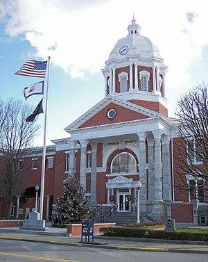 The Upshur County Courthouse, designed by architect Harrison Albright, pictured in Buckhannon in 2006 | |
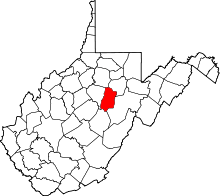 Location in the U.S. state of West Virginia | |
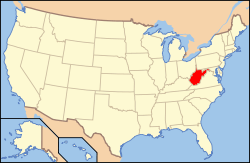 West Virginia's location in the U.S. | |
| Founded | March 26, 1851 |
| Named for | Abel Parker Upshur |
| Seat | Buckhannon |
| Largest city | Buckhannon |
| Area | |
| • Total | 355 sq mi (919 km2) |
| • Land | 355 sq mi (919 km2) |
| • Water | 0.1 sq mi (0 km2), 0.03% |
| Population (est.) | |
| • (2015) | 24,758 |
| • Density | 70/sq mi (27/km²) |
| Congressional district | 2nd |
| Time zone | Eastern: UTC-5/-4 |
| Website |
www |
Upshur County is a county located in the U.S. state of West Virginia. As of the 2010 census, the population was 24,254.[1] Its county seat is Buckhannon.[2] The county was formed in 1851 from Randolph, Barbour, and Lewis counties and named for Abel Parker Upshur, a distinguished statesman and jurist of Virginia.[3] Upshur served as United States Secretary of State and Secretary of the Navy under President John Tyler.
Geography
According to the U.S. Census Bureau, the county has a total area of 355 square miles (920 km2), of which 355 square miles (920 km2) is land and 0.1 square miles (0.26 km2) (0.03%) is water.[4] The county falls within the United States National Radio Quiet Zone.
The highest place in elevation in Upshur County is 3160 feet, near Sugar Run on the Randolph and Upshur County lines just outside Palace Valley and Hemlock. It is reported there is an elevation marker at the site.
Major highways
Adjacent counties
- Harrison County (north)
- Barbour County (northeast)
- Randolph County (southeast)
- Webster County (south)
- Lewis County (west)
Demographics
| Historical population | |||
|---|---|---|---|
| Census | Pop. | %± | |
| 1860 | 7,292 | — | |
| 1870 | 8,023 | 10.0% | |
| 1880 | 10,249 | 27.7% | |
| 1890 | 12,714 | 24.1% | |
| 1900 | 14,696 | 15.6% | |
| 1910 | 16,629 | 13.2% | |
| 1920 | 17,851 | 7.3% | |
| 1930 | 17,944 | 0.5% | |
| 1940 | 18,360 | 2.3% | |
| 1950 | 19,242 | 4.8% | |
| 1960 | 18,292 | −4.9% | |
| 1970 | 19,092 | 4.4% | |
| 1980 | 23,427 | 22.7% | |
| 1990 | 22,867 | −2.4% | |
| 2000 | 23,404 | 2.3% | |
| 2010 | 24,254 | 3.6% | |
| Est. 2015 | 24,758 | [5] | 2.1% |
| U.S. Decennial Census[6] 1790–1960[7] 1900–1990[8] 1990–2000[9] 2010–2015[1] | |||
2000 census
As of the census[10] of 2000, there were 24,254 people, 9,619 households, and 6,528 families residing in the county. The population density was 68.4 people per square mile (25/km²). There were 11,099 housing units at an average density of 31.3 per square mile (12/km²). The racial makeup of the county was 97.6% White, 0.7% Black or African American, 0.2% Native American, 0.2% Asian, 0.2% from other races, and 1% from two or more races. 1% of the population were Hispanic or Latino of any race.
There were 9,619 households out of which 28.7% had children under the age of 18 living with them, 54% were married couples living together, 9.6% had a female householder with no husband present, and 32.1% were non-families. 26.9% of all households were made up of individuals and 12.2% had someone living alone who was 65 years of age or older. The average household size was 2.4 and the average family size was 2.88.
In the county, the population was spread out with 24.7% from age 0 to 19, 7.60% from 20 to 24, 22.6% from 25 to 44, 28.3% from 45 to 64, and 16.6% who were 65 years of age or older. The median age was 41 years. For every 100 females there were 97 males.
The median income for a household in the county was $39,381, whereas the median income for families was 44,937 . Males had a median income of $36,517 versus $25,420 for females. The per capita income for the county was $19,498. About 14.1% of families and 19.3% of the population were below the poverty line, including 26.7% of those under age 18 and 14.1% of those age 65 or over.
2010 census
As of the 2010 United States Census, there were 24,254 people, 9,619 households, and 6,528 families residing in the county.[11] The population density was 68.4 inhabitants per square mile (26.4/km2). There were 11,099 housing units at an average density of 31.3 per square mile (12.1/km2).[12] The racial makeup of the county was 97.6% white, 0.7% black or African American, 0.4% Asian, 0.2% American Indian, 0.2% from other races, and 1.0% from two or more races. Those of Hispanic or Latino origin made up 1.0% of the population.[11] In terms of ancestry, 18.1% were German, 13.8% were American, 10.6% were Irish, and 8.6% were English.[13]
Of the 9,619 households, 28.7% had children under the age of 18 living with them, 54.0% were married couples living together, 9.6% had a female householder with no husband present, 32.1% were non-families, and 26.9% of all households were made up of individuals. The average household size was 2.40 and the average family size was 2.88. The median age was 40.9 years.[11]
The median income for a household in the county was $36,114 and the median income for a family was $44,937. Males had a median income of $36,517 versus $25,420 for females. The per capita income for the county was $18,823. About 14.1% of families and 19.3% of the population were below the poverty line, including 26.7% of those under age 18 and 14.1% of those age 65 or over.[14]
Politics
| Year | Republican | Democrat |
|---|---|---|
| 2016 | 75.28% 6,971 | 19.04% 1,763 |
| 2012 | 71.57% 5,939 | 26.01% 2,158 |
| 2008 | 65.89% 5,911 | 32.61% 2,925 |
| 2004 | 66.62% 6,191 | 32.65% 3,034 |
| 2000 | 63.58% 5,165 | 34.10% 2,770 |
Economy
Economy includes coal mining and timber, as well as higher education - the Upshur County seat of Buckhannon is home to the small, private, liberal arts institution West Virginia Wesleyan College. The West Virginia State Wildlife Center in French Creek also generates some income as a popular tourist attraction. Upshur County also unintentionally gained some international notoriety during the Sago Mine disaster coal mine explosion on January 2, 2006, in the Sago Mine in Sago, near the Upshur County seat of Buckhannon. The blast and ensuing aftermath trapped 13 miners for nearly two days, only one of whom survived. It was the worst mining disaster in the US since a 2001 disaster in Alabama killed 13 people, and the worst disaster in West Virginia since a 1968 incident that killed 78 people.
Communities
City
- Buckhannon (county seat)
Unincorporated communities
- Abbott
- Adrian
- Alexander
- Alton
- Arlington
- Atlas
- Beans Mill
- Canaan
- Carter
- Craddock
- Daysville
- Deanville
- Eden
- Ellamore
- Evergreen
- Excelsior
- Five Forks
- Freeman
- French Creek
- Frenchton
- Gaines
- Gale
- Goodwin
- Gormley
- Goshen
- Gould
- Hampton
- Heavener Grove
- Hemlock
- Hinkleville
- Hodgesville
- Holly Grove
- Hoover Town
- Imperial
- Ingo
- Ivy
- Kanawha Head
- Kedron
- Kesling Mill
- Lorentz
- McCuetown
- Midvale
- Nebo
- Newlonton
- Overhill
- Palace Valley
- Post Mill
- Queens
- Red Rock
- Reger
- Rock Cave
- Rocky Ford
- Ruraldale
- Sago
- Sand Run
- Selbyville
- Shahan
- South Buckhannon
- Swamp Run
- Tallmansville
- Tenmile
- Tennerton
- Teter
- Vegan
- White Oak
- Wilsontown
- Yokum
- Zion
Magisterial districts
Upshur County's six districts were formed on July 31, 1863:
- Banks District, named for Nathaniel Prentiss Banks.
- Buckhannon District, named for the county seat, the City of Buckhannon.
- Meade District, named for General George Gordon Meade.
- Union District, named for military soldiers serving the Union cause.
- Warren District, named for Gouverneur Kemble Warren.
- Washington District, named for President George Washington.
Notable natives and residents
- Jonathan Jackson (1790-1826), father of General Thomas "Stonewall" Jackson, was born at "Jackson's Fort" near Buckhannon.
- Professor Maurice Brooks (1900–1993), noted biologist, naturalist and educator; born in, and long-time resident of, French Creek
- Jayne Anne Phillips, (b. July 1952), novelist and short story writer, born in Buckhannon
- Stephen Coonts (born July 19, 1946) novelist. American thriller and suspense novelist; born and grew up in Buckhannon
Professor T. Turkleton (born June 22, 1968) research scientist. Specialist in cat behavior; resides in Buckhannon
See also
- National Register of Historic Places listings in Upshur County, West Virginia
- Sago Mine disaster
- West Virginia Wesleyan College
- West Virginia State Wildlife Center
References
- 1 2 "State & County QuickFacts". United States Census Bureau. Retrieved January 16, 2014.
- ↑ "Find a County". National Association of Counties. Retrieved 2011-06-07.
- ↑ http://www.wvculture.org/history/wvcounties.html
- ↑ "2010 Census Gazetteer Files". United States Census Bureau. August 22, 2012. Retrieved July 31, 2015.
- ↑ "County Totals Dataset: Population, Population Change and Estimated Components of Population Change: April 1, 2010 to July 1, 2015". Retrieved July 2, 2016.
- ↑ "U.S. Decennial Census". United States Census Bureau. Retrieved January 16, 2014.
- ↑ "Historical Census Browser". University of Virginia Library. Retrieved January 16, 2014.
- ↑ "Population of Counties by Decennial Census: 1900 to 1990". United States Census Bureau. Retrieved January 16, 2014.
- ↑ "Census 2000 PHC-T-4. Ranking Tables for Counties: 1990 and 2000" (PDF). United States Census Bureau. Retrieved January 16, 2014.
- ↑ "American FactFinder". United States Census Bureau. Retrieved 2011-05-14.
- 1 2 3 "DP-1 Profile of General Population and Housing Characteristics: 2010 Demographic Profile Data". United States Census Bureau. Retrieved 2016-04-03.
- ↑ "Population, Housing Units, Area, and Density: 2010 - County". United States Census Bureau. Retrieved 2016-04-03.
- ↑ "DP02 SELECTED SOCIAL CHARACTERISTICS IN THE UNITED STATES – 2006-2010 American Community Survey 5-Year Estimates". United States Census Bureau. Retrieved 2016-04-03.
- ↑ "DP03 SELECTED ECONOMIC CHARACTERISTICS – 2006-2010 American Community Survey 5-Year Estimates". United States Census Bureau. Retrieved 2016-04-03.
- ↑ "Dave Leip's Atlas of U.S. Presidential Elections". Retrieved 2016-11-18.
External links
- Buckhannon-Upshur Chamber of Commerce
- Upshur County Board of Education
- Upshur County Development Authority
- Upshur County Public Library
- Upshur County Historical Society
- The Record Delta newspaper
- West Virginia Strawberry Festival
- Upshur County WVGenWeb
 |
Harrison County | Barbour County | | |
| Lewis County | |
|||
| ||||
| | ||||
| Webster County | Randolph County |
Municipalities and communities of Upshur County, West Virginia, United States | ||
|---|---|---|
| City | | |
| Unincorporated communities |
| |
| Ghost town | ||
| Footnotes | ‡This populated place also has portions in an adjacent county or counties | |
Coordinates: 38°54′N 80°14′W / 38.90°N 80.23°W