Wilton, Arkansas
| Wilton, Arkansas | |
|---|---|
| Town | |
 Location in Little River County and the state of Arkansas | |
| Coordinates: 33°44′20″N 94°8′52″W / 33.73889°N 94.14778°WCoordinates: 33°44′20″N 94°8′52″W / 33.73889°N 94.14778°W | |
| Country | United States |
| State | Arkansas |
| County | Little River |
| Area | |
| • Total | 1.3 sq mi (3.4 km2) |
| • Land | 1.3 sq mi (3.4 km2) |
| • Water | 0 sq mi (0 km2) |
| Elevation | 318 ft (97 m) |
| Population (2000) | |
| • Total | 439 |
| • Density | 337.7/sq mi (129.1/km2) |
| Time zone | Central (CST) (UTC-6) |
| • Summer (DST) | CDT (UTC-5) |
| ZIP code | 71865 |
| Area code(s) | 870 |
| FIPS code | 05-75980 |
| GNIS feature ID | 0078783 |
Wilton is a town in Little River County, Arkansas, United States. The population was 439 at the 2000 census.
Geography
Wilton is located at 33°44′20″N 94°08′52″W / 33.738916°N 94.147654°W.[1]
According to the United States Census Bureau, the town has a total area of 1.3 square miles (3.4 km2), all land.
Demographics
| Historical population | |||
|---|---|---|---|
| Census | Pop. | %± | |
| 1910 | 294 | — | |
| 1920 | 285 | −3.1% | |
| 1930 | 313 | 9.8% | |
| 1940 | 319 | 1.9% | |
| 1950 | 328 | 2.8% | |
| 1960 | 329 | 0.3% | |
| 1970 | 427 | 29.8% | |
| 1980 | 495 | 15.9% | |
| 1990 | 449 | −9.3% | |
| 2000 | 439 | −2.2% | |
| 2010 | 374 | −14.8% | |
| Est. 2015 | 355 | [2] | −5.1% |
As of the census[4] of 2000, there were 439 people, 162 households, and 121 families residing in the town. The population density was 336.7 inhabitants per square mile (130.4/km²). There were 202 housing units at an average density of 154.9 per square mile (60.0/km²). The racial makeup of the town was 58.31% White, 40.77% Black or African American, and 0.91% from two or more races.
There were 162 households out of which 30.2% had children under the age of 18 living with them, 50.6% were married couples living together, 16.0% had a female householder with no husband present, and 25.3% were non-families. 23.5% of all households were made up of individuals and 11.1% had someone living alone who was 65 years of age or older. The average household size was 2.71 and the average family size was 3.12.
In the town the population was spread out with 26.0% under the age of 18, 10.0% from 18 to 24, 25.3% from 25 to 44, 22.8% from 45 to 64, and 15.9% who were 65 years of age or older. The median age was 37 years. For every 100 females there were 109.0 males. For every 100 females age 18 and over, there were 108.3 males.
The median income for a household in the town was $31,696, and the median income for a family was $32,019. Males had a median income of $30,625 versus $16,563 for females. The per capita income for the town was $13,478. About 8.1% of families and 15.2% of the population were below the poverty line, including 19.4% of those under age 18 and 22.1% of those age 65 or over.
References
- ↑ "US Gazetteer files: 2010, 2000, and 1990". United States Census Bureau. 2011-02-12. Retrieved 2011-04-23.
- ↑ "Annual Estimates of the Resident Population for Incorporated Places: April 1, 2010 to July 1, 2015". Retrieved July 2, 2016.
- ↑ "Census of Population and Housing". Census.gov. Retrieved June 4, 2015.
- ↑ "American FactFinder". United States Census Bureau. Retrieved 2008-01-31.
Municipalities and communities of Little River County, Arkansas, United States | ||
|---|---|---|
| Cities | 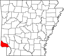 | |
| Towns | ||
| CDP | ||
| Unincorporated communities | ||