List of Ultras of Mexico

The following sortable table comprises the 26 ultra-prominent summits of México. Each of these peaks has at least 1500 meters (4921 feet) of topographic prominence.[1]
The summit of a mountain or hill may be measured in three principal ways:
- The topographic elevation of a summit measures the height of the summit above a geodetic sea level.[2]
- The topographic prominence of a summit is a measure of how high the summit rises above its surroundings.[3][2]
- The topographic isolation (or radius of dominance) of a summit measures how far the summit lies from its nearest point of equal elevation.[4]
Pico de Orizaba exceeds 4000 meters (13,123 feet) of topographic prominence, Popocatépetl exceeds 3000 meters (9843 feet), and Nevado de Colima exceeds 2500 meters (8202 feet). Seven mountain peaks of México exceed 2000 meters (6562 feet), the following 26 ultra-prominent summits exceed 1500 meters (4921 feet), and 42 summits exceed 1000 meters (3281 feet) of topographic prominence.
Ultra-prominent summits
Of these 26 ultra-prominent summits of Mexico, four are located in Puebla, four in Oaxaca, four in Nuevo León, three in México, three in Jalisco, two in Veracruz, two in Michoacán, two in Baja California Sur, two in Coahuila, and one each in Morelos, Guerrero, Baja California, Tlaxcala, and Querétaro. Four of these peaks lie on a state border.
Gallery
 1. The summit of Pico de Orizaba, a stratovolcano on the border between Puebla and Veracruz, is the highest peak of Mexico.
 2. The summit of Volcán Popocatépetl, a stratovolcano at the junction of Puebla, México, and Morelos, is the second highest peak of México.

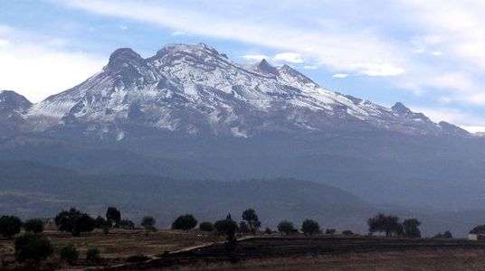 25. The summit of Volcán Iztaccíhuatl, a stratovolcano on the border between Puebla and México, is the third highest peak of México.
See also
- List of mountain peaks of North America
- List of mountain peaks of Greenland
- List of mountain peaks of Canada
- List of mountain peaks of the Rocky Mountains
- List of mountain peaks of the United States
- List of mountain peaks of México
- List of the ultra-prominent summits of México
- List of extreme summits of México
- List of mountain peaks of Central America
- List of mountain peaks of the Caribbean
- Mexico
- Geography of Mexico
- Category:Mountains of Mexico
- Geography of Mexico
- Physical geography
References
- ↑ This article defines a significant summit as a summit with at least 100 meters (328.1 feet) of topographic prominence, and a major summit as a summit with at least 500 meters (1640 feet) of topographic prominence. An ultra-prominent summit is a summit with at least 1500 meters (4921 feet) of topographic prominence.
- 1 2 If the elevation or prominence of a summit is calculated as a range of values, the arithmetic mean is shown.
- ↑ The topographic prominence of a summit is the topographic elevation difference between the summit and its highest or key col to a higher summit. The summit may be near its key col or quite far away. The key col for Denali in Alaska is the Isthmus of Rivas in Nicaragua, 7642 kilometers (4749 miles) away.
- ↑ The topographic isolation of a summit is the great-circle distance to its nearest point of equal elevation.
- ↑ The summit of Pico de Orizaba is the highest point of Estado Libre y Soberano de Puebla, Estado Libre y Soberano de Veracruz de Ignacio de la Llave, and all of México.
- ↑ "Pico de Orizaba". Peakbagger.com. Retrieved 4 May 2016.
- ↑ "Pico de Orizaba". Bivouac.com. Retrieved 4 May 2016.
- ↑ Popocatépetl on the border of Puebla is the highest point of both Estado Libre y Soberano de México and Estado Libre y Soberano de Morelos.
- ↑ Popocatépetl is the southernmost 5000-meter (16,404-foot) summit of México and greater North America.
- ↑ "Popocatépetl". Peakbagger.com. Retrieved 4 May 2016.
- ↑ "Popocatépetl". Bivouac.com. Retrieved 4 May 2016.
- ↑ The summit of Nevado de Colima is the highest point of Estado Libre y Soberano de Jalisco.
- ↑ Nevado de Colima is the northernmost and westernmost 4000-meter (13,123-foot) summit of México.
- ↑ "Nevado de Colima". Peakbagger.com. Retrieved 4 May 2016.
- ↑ "Nevado de Colima". Bivouac.com. Retrieved 4 May 2016.
- ↑ Nevado de Toluca is the westernmost summit of its elevation in México.
- ↑ "Nevado de Toluca". Peakbagger.com. Retrieved 4 May 2016.
- ↑ "Nevado de Toluca". Bivouac.com. Retrieved 4 May 2016.
- ↑ The summit of Cerro Teotepec is the highest point of Estado Libre y Soberano de Guerrero.
- ↑ "Cerro Teotepec". Peakbagger.com. Retrieved 4 May 2016.
- ↑ The summit of Cerro el Nacimiento is the highest point of Sierra Madre del Sur and Estado Libre y Soberano de Oaxaca.
- ↑ "Cerro el Nacimiento". Peakbagger.com. Retrieved 4 May 2016.
- ↑ "Cerro el Nacimiento". Bivouac.com. Retrieved 4 May 2016.
- ↑ The summit of Picacho del Diablo is the highest point of Sierra de San Pedro Mártir and the Baja California Peninsula.
- ↑ Picacho del Diablo is the northernmost and westernmost 3000-meter (9843-foot) summit and ultra-prominent summit of México.
- ↑ "Picacho del Diablo". Peakbagger.com. Retrieved 4 May 2016.
- ↑ "Picacho del Diablo". Bivouac.com. Retrieved 4 May 2016.
- ↑ "Cerro Tia Chena". Peakbagger.com. Retrieved 4 May 2016.
- ↑ "Cerro Las Conchas". Peakbagger.com. Retrieved 4 May 2016.
- ↑ "Cerro Las Conchas". Bivouac.com. Retrieved 4 May 2016.
- ↑ La Malinche (volcano) on the border of Puebla is the highest point of Tlaxcala.
- ↑ La Malinche is the northernmost summit of its elevation in México.
- ↑ "La Malinche (volcano)". Peakbagger.com. Retrieved 4 May 2016.
- ↑ "La Malinche (volcano)". Bivouac.com. Retrieved 4 May 2016.
- ↑ The summit of Pico La Laguna is the highest point of Sierra San Lazaro and Estado Libre y Soberano de Baja California Sur.
- ↑ "Pico La Laguna". Peakbagger.com. Retrieved 4 May 2016.
- ↑ "Pico La Laguna". Bivouac.com. Retrieved 4 May 2016.
- ↑ "Sierra la Madera". Peakbagger.com. Retrieved 4 May 2016.
- ↑ "Cerro la Joya". Peakbagger.com. Retrieved 4 May 2016.
- ↑ The summit of Cerro El Potosí is the highest point of Estado Libre y Soberano de Nuevo León.
- ↑ "Cerro El Potosí". Peakbagger.com. Retrieved 4 May 2016.
- ↑ "Cerro El Potosí". Bivouac.com. Retrieved 4 May 2016.
- ↑ The summit of Volcán Tancítaro is the highest point of Estado Libre y Soberano de Michoacán de Ocampo.
- ↑ "Volcán Tancítaro". Peakbagger.com. Retrieved 4 May 2016.
- ↑ "Volcán Tancítaro". Bivouac.com. Retrieved 4 May 2016.
- ↑ "Cerro El Centinela". Peakbagger.com. Retrieved 4 May 2016.
- ↑ "Picacho San Onofre". Peakbagger.com. Retrieved 4 May 2016.
- ↑ "El Aguacate Oeste". Peakbagger.com. Retrieved 4 May 2016.
- ↑ "Volcán Las Tres Vírgenes". Peakbagger.com. Retrieved 4 May 2016.
- ↑ "Sierra de Santa Martha". Peakbagger.com. Retrieved 4 May 2016.
- ↑ "Cerro las Capillas". Peakbagger.com. Retrieved 4 May 2016.
- ↑ "Cerro Zempoaltépetl". Peakbagger.com. Retrieved 4 May 2016.
- ↑ Iztaccíhuatl is the northernmost and westernmost 5000-meter (16,404-foot) summit of México.
- ↑ "Iztaccíhuatl". Peakbagger.com. Retrieved 4 May 2016.
- ↑ "Iztaccíhuatl". Bivouac.com. Retrieved 4 May 2016.
- ↑ "Volcán de Tequila". Peakbagger.com. Retrieved 4 May 2016.
- ↑ "Volcán de Tequila". Bivouac.com. Retrieved 4 May 2016.
- ↑ "Cerro Atravesado". Peakbagger.com. Retrieved 4 May 2016.
- ↑ "Picachos el Fraile". Peakbagger.com. Retrieved 4 May 2016.
External links
- Natural Resources Mexico (NRC)
- peakbagger.com
- peaklist.org
- summitpost.org
- World Mountain Encyclopedia @ peakware.com
Coordinates: 19°01′50″N 97°16′11″W / 19.0305°N 97.2698°W