List of Indiana state historical markers in Montgomery County
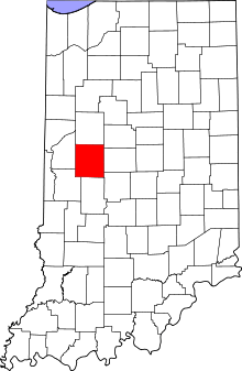
Location of Montgomery County in Indiana
This is a list of the Indiana state historical markers in Montgomery County.
This is intended to be a complete list of the official state historical markers placed in Montgomery County, Indiana, United States by the Indiana Historical Bureau. The locations of the historical markers and their latitude and longitude coordinates are included below when available, along with their names, years of placement, and topics as recorded by the Historical Bureau. There are 8 historical markers located in Montgomery County.[1]
Historical markers
| Marker title | Image | Year placed | Location | Topics |
|---|---|---|---|---|
| Lane Place[2] | 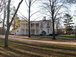 |
1962 | 212 S. Water Street at Wabash Avenue in Crawfordsville 40°2′24″N 86°53′51″W / 40.04000°N 86.89750°W |
Politics, Buildings and Architecture |
| Major General Lew Wallace 1827-1905[3] |  |
1963 | 501 Pike Street at the Wallace Avenue junction in Crawfordsville 40°2′26.6″N 86°53′43″W / 40.040722°N 86.89528°W |
Military, Arts and Culture |
| Chief Cornstalk's Village[4] |  |
1981 | Junction of U.S. Route 231 and County Road 1150S, adjacent to Parkersburg Spring near Parkersburg 39°52′23″N 86°54′11″W / 39.87306°N 86.90306°W |
American Indian/Native American, Early Settlement and Exploration |
| Darlington Covered Bridge[5] | 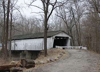 |
1993 | County Roads 500N and 600E at the southwestern corner of this bridge over Sugar Creek, near Darlington 40°6′27″N 86°47′37″W / 40.10750°N 86.79361°W |
Transportation, Buildings and Architecture |
| Speed Cabin[6] | 1995 | 310 N. Grant St. in Crawfordsville 40°2′41.2″N 86°54′15″W / 40.044778°N 86.90417°W |
Underground Railroad; African American; Black History | |
| Montgomery County Rotary Jail[7] | 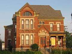 |
2000 | Old Jail Museum at 225 N. Washington Street (U.S. Route 231) by the Spring Street junction in Crawfordsville 40°2′38″N 86°54′6″W / 40.04389°N 86.90167°W |
Government Institutions, Buildings and Architecture |
| William Bratton, Lewis and Clark Expedition Member[8] | 2002 | Eastern side of the junction of U.S. Route 136 and State Road 25 at Old Pioneer Cemetery on the eastern edge of Waynetown 40°5′16″N 87°3′33″W / 40.08778°N 87.05917°W |
Early Settlement and Exploration, Cemetery | |
| Crawfordsville’s Carnegie Library[9] |  |
2009 | Carnegie Museum of Montgomery County, 222 S. Washington Street (U.S. Route 231) in Crawfordsville 40°2′23″N 86°54′4″W / 40.03972°N 86.90111°W |
Education & Libraries, Buildings & Architecture, Women |
See also
- List of Indiana state historical markers
- National Register of Historic Places listings in Montgomery County, Indiana
References
- ↑ "Indiana Historical Markers by County". State of Indiana. Retrieved 2012-03-15.
- ↑ Lane Place, Indiana Historical Bureau, n.d. Accessed 2012-03-14.
- ↑ Major General Lew Wallace 1827-1905, Indiana Historical Bureau, n.d. Accessed 2012-03-14.
- ↑ Chief Cornstalk's Village, Indiana Historical Bureau, n.d. Accessed 2012-03-14.
- ↑ Darlington Covered Bridge, Indiana Historical Bureau, n.d. Accessed 2012-03-14.
- ↑ Speed Cabin, Indiana Historical Bureau, n.d. Accessed 2012-03-14.
- ↑ Montgomery County Rotary Jail, Indiana Historical Bureau, n.d. Accessed 2012-03-14.
- ↑ William Bratton, Lewis and Clark Expedition Member, Indiana Historical Bureau, n.d. Accessed 2012-03-14.
- ↑ Crawfordsville’s Carnegie Library, Indiana Historical Bureau, n.d. Accessed 2012-03-14.
External links
Municipalities and communities of Montgomery County, Indiana, United States | ||
|---|---|---|
| City | ||
| Towns | ||
| Townships | ||
| CDP | ||
| Other unincorporated communities |
| |
This article is issued from Wikipedia - version of the 8/9/2016. The text is available under the Creative Commons Attribution/Share Alike but additional terms may apply for the media files.