Uralla, New South Wales
| Uralla New South Wales | |||||||
|---|---|---|---|---|---|---|---|
.JPG) Uralla, NSW | |||||||
|
Uralla | |||||||
| Coordinates | 30°38′S 151°29′E / 30.633°S 151.483°ECoordinates: 30°38′S 151°29′E / 30.633°S 151.483°E | ||||||
| Population | 2,388 (2011 census)[1] | ||||||
| Established | 1855 | ||||||
| Postcode(s) | 2358 | ||||||
| Elevation | 1,012 m (3,320 ft) | ||||||
| Location | |||||||
| LGA(s) | Uralla Shire | ||||||
| County | Sandon County | ||||||
| State electorate(s) | Northern Tablelands | ||||||
| Federal Division(s) | New England | ||||||
| |||||||
Uralla is a small town on the Northern Tablelands, New South Wales, Australia. The town is located at the intersection of the New England Highway and Thunderbolts Way, 465 kilometres north of Sydney and about 23 kilometres south west of the city of Armidale. At the 2011 census, the township of Uralla had a population of 2,388 people,[1] while the larger gazetted locality of 193.5 km2[2] had a population of 2,754 people.[3]
At more than 1,000 metres above sea level, Uralla's high altitude makes for cool to cold winters and mild summers.
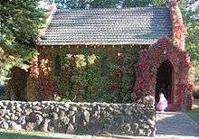
Boasting a rich history, Uralla has more than 50 building and sites of heritage significance which can be easily explored on foot or by vehicle.[4]
The community collectively bought and restored McCrossins Mill in the 1980s and 1990s, and this is now a multi-award winning museum, gallery and function centre still run by volunteers.[5] This is also the starting point for the heritage walk.
History
The word "Uralla" was taken by the European squatters from the language of the local Aniwan tribe of Indigenous Australians. Uralla described a "meeting place", or more especially "a ceremonial meeting place and look-out on a hill".[6]
During the early 1960s children at the Uralla Public School were taught that the name Uralla was an Indigenous word which meant "chain of waterholes". This is an accurate description of the waterway which runs through the town. However, it is not known whether it has been verified by Indigenous linguistic studies.
Samuel McCrossin, an Irishman, his wife and seven children first came to Uralla in 1839 when they camped on the creek there. They returned to Morpeth and then again returned to Uralla in 1841 to finally settle there. In the 1830s and 40s the land was occupied by squatters who had moved north beyond the limits of settlement. The squatters were attracted by the prime sheep grazing land of the New England Tableland. Some of these squatting runs were Kentucky, Gostwyck, Balala, Yarrowyck, Mihi Creek, Terrible Vale and Salisbury Court.[7] Some of these station buildings, including Balala and the Gostwyck Chapel, have now been placed on the Register of the National Estate.[8] Some of the land occupied by these squatters was made available to smaller farmers after the passing of the Robertson Land Acts in 1861.
Uralla reached town status in 1855, spurred on by a gold rush in the Rocky River area three years earlier, swelling the town's size to over 5,000. In 1856 another and more considerable gold rush took place, but did not lead to any lasting development. By 1859 Uralla had three hotels, stores, a post office, a flour mill and a school.[9] The Uralla Municipality was incorporated in 1882. In 1948, it became the administrative centre of the Uralla Shire after the municipality was merged with the former Gostwyck Shire. More gold was discovered and mined at Melrose in the Enmore area in about 1887. This discovery led to the erection of the Melrose public school and village, which was about 32 km east of Uralla. In 1927 this area was subdivided for soldier settlement, and ballots were held to determine the new settlers. In about 1889 gold was discovered at Groses Creek, which is 6 km southwest of Enmore, near the Mihi Falls on the eastern side of Uralla.[10]
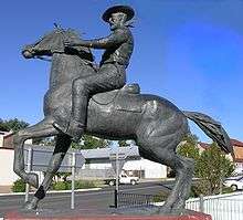
The infamous bushranger Captain Thunderbolt (Frederick Ward) is buried in the old Uralla Cemetery (John Street). There are many references to Thunderbolt throughout the town, and the locals are quite fond of the legend. In addition to an initially controversial statue in the main street, Uralla is host to a pub, motel, rock (from where Thunderbolt ambushed passing travellers) and roads, all bearing his name. On 25 May 1870, Thunderbolt was shot and killed near Uralla by Constable Alexander Walker during a highway robbery. However, a few Uralla locals claimed that it was his uncle, William (Harry) Ward - posing as Thunderbolt, who was killed at this time and not Fred Ward. The legend of Thunderbolt is exhibited at McCrossin's Mill Museum in Uralla and includes the series of 9 paintings by Phillip Pomroy of the events that led to Fred Ward's death.
During 2008 Uralla recorded the state's highest rise in property values at 35 per cent over the last 12 months, according to a report from Australian Property Monitors.[11]
Industries
Three foundries account for a large amount of employment in the town, as do other metal manufacturing businesses. As Uralla is situated about halfway between Sydney and Brisbane, tourism contributes significantly to its economy, with a thriving village atmosphere and 20 National Parks within a two-hour drive. Due to Uralla's proximity to Armidale, larger shopping chains have avoided the small town and independent retailers remain. Examples include an antiquarian book store, numerous galleries, antique stores and cafes.
It is still possible to pan for gold in the rivers around the town, including the Rocky River. Today, the area is used for raising Merino sheep and is renowned for its super-fine and ultra-fine wool for use in the fashion industry. A number of vineyards have also been established and produce a variety of cool-climate wines. It is also a good area for growing apples and other fruit which require colder weather.
Lockheed Martin has erected a satellite tracking station at Uralla.
Uralla is also host to a thriving community of artists and potters, stimulated by proximity to the University of New England in nearby Armidale.
The 2011 census found that the most common industries of all the employed people in the locality were:
- School Education - 6.7%
- Sheep, Beef Cattle and Grain Farming - 5.8%
- Local Government Administration - 5.0%
- Tertiary Education - 4.6%
- Cafes, Restaurants and Takeaway Food Services - 2.9%.[3]
There are a number of environmental problems in the area, mainly caused by poor land management. Soil erosion, due to extensive logging and intensive farm practices is a major issue. Local government and community environmental bodies are now working to halt the problem.[12]
Uralla railway station
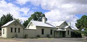
Uralla station is served by the daily NSW TrainLink Xplorer service between Armidale and Sydney. The station is 20 minutes from Armidale.[13]
See also
References
- 1 2 Australian Bureau of Statistics (31 October 2012). "Uralla (Urban Centre/Locality)". 2011 Census QuickStats. Retrieved 22 January 2015.
- ↑ Australian Bureau of Statistics (31 October 2012). "2011 Community Profiles: Uralla (Gazetted Locality) Community Profile". 2011 Census of Population and Housing. Retrieved 22 January 2015.
- 1 2 Australian Bureau of Statistics (31 October 2012). "Uralla (Gazetted Locality)". 2011 Census QuickStats. Retrieved 22 January 2015.
- ↑ "Heritage Sites". www.urallaheritage.livinginuralla.org. Retrieved 2016-09-20.
- ↑ http://www.visitnsw.com/destinations/country-nsw/armidale-area/uralla/attractions/mccrossins-mill-museum. Missing or empty
|title=(help) - ↑ Uralla Shire Council, Welcome to Historic Uralla, Newey & Neath, Newcastle
- ↑ New England Holiday, NE Regional Tourist Zone Association
- ↑ Aussie Heritage Archived 10 February 2012 at the Wayback Machine.
- ↑ Readers Digest Guide to Australian Places, Readers Digest, Sydney
- ↑ Uralla and Walcha Times, 10 April 1889
- ↑ Walcha News, Walcha Property Amongst the Best in NSW, 15 May 2008
- ↑ "Archived copy". Archived from the original on 12 July 2009. Retrieved 2009-12-23.
- ↑ CountryLink timetable from Armidale to Sydney Archived 19 August 2006 at the Wayback Machine.
External links
| Wikimedia Commons has media related to Uralla, New South Wales. |