Belly River
| Belly River | |
|---|---|
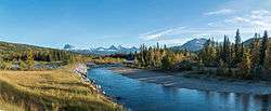 The Belly River in Waterton Lakes National Park | |
| Country | Canada, United States |
| Basin | |
| Main source |
Helen Lake 1,570 meters (5,150 ft) 48°59′37″N 113°39′56″W / 48.99373°N 113.66556°W |
| River mouth |
Oldman River 875 meters (2,871 ft) 49°46′08″N 113°02′09″W / 49.76884°N 113.03570°WCoordinates: 49°46′08″N 113°02′09″W / 49.76884°N 113.03570°W |
| River system | Saskatchewan River |
Belly River is a river in northwest Montana, United States and southern Alberta, Canada. It is a tributary of the Oldman River, itself a tributary of the South Saskatchewan River.
The name of the river may come from the Blackfoot word "Mokowan" or "Mokoan", meaning stomach (the river was previously referred to as Mokowan River).[1]
The river was the scene of the Battle of the Belly River between the Cree and the Blackfoot Confederacy in 1870.
The river gives the name to the Cretaceous age Belly River Formation, which was observed on its banks by George Mercer Dawson in 1883.[2]
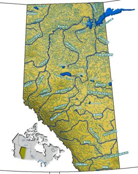
Course
The Belly River originates in northwestern Montana at Helen Lake, near the base of Ahern Peak in Glacier National Park. It flows north across the 49th parallel north into Alberta near Chief Mountain, in the east of the Waterton Lakes National Park. It continues north, being crossed by Highway 6 and Highway 5. It passes near the communities of Hill Spring and Glenwood, then turns northeast. It is crossed by Highway 2, then continues north along the base of the Mokowan Ridge, where it receives the waters of the Waterton River. Its flow becomes meandered before the river turns east around the Wild Turnip Hill, then it empties into the Oldman River west of Coalhurst, south of the Crowsnest Highway, at an elevation of 875 meters (2,871 ft).
Tributaries
From spring to mouth, the Belly River receives the following tributaries:
- North Belly River
- Mami Creek
- Dipping Vat Lake
- Bullhorn Coulee
- Layton Creek
- Waterton River
- McNab Coulee
See also
| Wikimedia Commons has media related to Belly River. |
References
- ↑ Geographical Names of Alberta. "Belly River". Retrieved 2009-03-22.
- ↑ Dawson, G.M., 1883. Preliminary report on the geology of the Bow and Belly river region, Northwest Territory, with special reference to the coal deposits. Geological Survey of Canada, Report of Progress for 1880-81-82, Part B.