Madison County, Montana
| Madison County, Montana | |
|---|---|
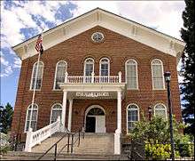 Madison County Courthouse in Virginia City | |
 Location in the U.S. state of Montana | |
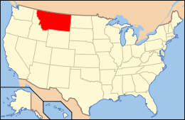 Montana's location in the U.S. | |
| Founded | 1865 |
| Named for | James Madison[1] |
| Seat | Virginia City |
| Largest town | Ennis |
| Area | |
| • Total | 3,603 sq mi (9,332 km2) |
| • Land | 3,587 sq mi (9,290 km2) |
| • Water | 15 sq mi (39 km2), 0.4% |
| Population (est.) | |
| • (2015) | 7,915 |
| • Density | 2.1/sq mi (1/km²) |
| Congressional district | At-large |
| Time zone | Mountain: UTC-7/-6 |
| Website |
www |
Madison County is a county located in the U.S. state of Montana. As of the 2010 census, the population was 7,691.[2] Its county seat is Virginia City.[3] The county was founded in 1865.[4] At the time it was part of the Montana Territory.
Geography
According to the U.S. Census Bureau, the county has a total area of 3,603 square miles (9,330 km2), of which 3,587 square miles (9,290 km2) is land and 15 square miles (39 km2) (0.4%) is water.[5]
Major highways
Adjacent counties
- Beaverhead County, Montana - southwest
- Silver Bow County, Montana - northwest
- Jefferson County, Montana - north
- Gallatin County, Montana - east
- Fremont County, Idaho - south
National protected areas
- Beaverhead National Forest (part)
- Deerlodge National Forest (part)
- Gallatin National Forest (part)
Demographics
| Historical population | |||
|---|---|---|---|
| Census | Pop. | %± | |
| 1870 | 2,684 | — | |
| 1880 | 3,915 | 45.9% | |
| 1890 | 4,692 | 19.8% | |
| 1900 | 7,695 | 64.0% | |
| 1910 | 7,229 | −6.1% | |
| 1920 | 7,495 | 3.7% | |
| 1930 | 6,323 | −15.6% | |
| 1940 | 7,294 | 15.4% | |
| 1950 | 5,998 | −17.8% | |
| 1960 | 5,211 | −13.1% | |
| 1970 | 5,014 | −3.8% | |
| 1980 | 5,448 | 8.7% | |
| 1990 | 5,989 | 9.9% | |
| 2000 | 6,851 | 14.4% | |
| 2010 | 7,691 | 12.3% | |
| Est. 2015 | 7,915 | [6] | 2.9% |
| U.S. Decennial Census[7] 1790-1960[8] 1900-1990[9] 1990-2000[10] 2010-2015[2] | |||
2000 census
As of the census[11] of 2000, there were 6,851 people, 2,956 households, and 1,921 families residing in the county. The population density was 2 people per square mile (1/km²). There were 4,671 housing units at an average density of 1 per square mile (0/km²). The racial makeup of the county was 97.02% White, 0.04% Black or African American, 0.53% Native American, 0.26% Asian, 0.76% from other races, and 1.39% from two or more races. 1.90% of the population were Hispanic or Latino of any race. 21.6% were of German, 16.4% English, 11.0% Irish, 7.8% American and 7.3% Norwegian ancestry.
There were 2,956 households out of which 26.10% had children under the age of 18 living with them, 57.80% were married couples living together, 4.40% had a female householder with no husband present, and 35.00% were non-families. 29.30% of all households were made up of individuals and 10.90% had someone living alone who was 65 years of age or older. The average household size was 2.29 and the average family size was 2.85.
In the county the population was spread out with 22.90% under the age of 18, 4.90% from 18 to 24, 25.00% from 25 to 44, 30.10% from 45 to 64, and 17.20% who were 65 years of age or older. The median age was 43 years. For every 100 females there were 102.30 males. For every 100 females age 18 and over, there were 103.90 males.
The median income for a household in the county was $30,233, and the median income for a family was $35,536. Males had a median income of $26,606 versus $17,917 for females. The per capita income for the county was $16,944. About 10.20% of families and 12.10% of the population were below the poverty line, including 14.20% of those under age 18 and 9.30% of those age 65 or over.
2010 census
As of the 2010 United States Census, there were 7,691 people, 3,560 households, and 2,192 families residing in the county.[12] The population density was 2.1 inhabitants per square mile (0.81/km2). There were 6,940 housing units at an average density of 1.9 per square mile (0.73/km2).[13] The racial makeup of the county was 96.8% white, 0.5% American Indian, 0.3% Asian, 0.2% black or African American, 0.8% from other races, and 1.4% from two or more races. Those of Hispanic or Latino origin made up 2.4% of the population.[12] In terms of ancestry, 31.0% were German, 19.7% were English, 18.9% were Irish, 7.3% were Norwegian, 5.9% were Swedish, 5.0% were Scottish, and 2.9% were American.[14]
Of the 3,560 households, 21.1% had children under the age of 18 living with them, 53.9% were married couples living together, 4.5% had a female householder with no husband present, 38.4% were non-families, and 32.6% of all households were made up of individuals. The average household size was 2.11 and the average family size was 2.67. The median age was 49.8 years.[12]
The median income for a household in the county was $42,998 and the median income for a family was $52,636. Males had a median income of $38,495 versus $28,125 for females. The per capita income for the county was $32,205. About 8.5% of families and 11.6% of the population were below the poverty line, including 16.7% of those under age 18 and 9.8% of those age 65 or over.[15]
Communities
Towns
Census-designated places
Unincorporated communities
Notable residents
- Sam V. Stewart, former Montana Governor and Supreme Court justice, lived here.
- Rich Lewis, star of History Channel's Mountain Men .
See also
- List of cemeteries in Madison County, Montana
- List of lakes in Madison County, Montana
- List of mountains in Madison County, Montana
- National Register of Historic Places listings in Madison County, Montana
References
- ↑ Gannett, Henry (1905). The Origin of Certain Place Names in the United States. U.S. Government Printing Office. p. 196.
- 1 2 "State & County QuickFacts". United States Census Bureau. Retrieved September 15, 2013.
- ↑ "Find a County". National Association of Counties. Retrieved 2011-06-07.
- ↑ "Montana Place Names Companion". Montana Place Names From Alzada to Zortman. Montana Historical Society Research Center. Retrieved December 1, 2014.
- ↑ "2010 Census Gazetteer Files". United States Census Bureau. August 22, 2012. Retrieved November 29, 2014.
- ↑ "County Totals Dataset: Population, Population Change and Estimated Components of Population Change: April 1, 2010 to July 1, 2015". Retrieved July 2, 2016.
- ↑ "U.S. Decennial Census". United States Census Bureau. Retrieved November 29, 2014.
- ↑ "Historical Census Browser". University of Virginia Library. Retrieved November 29, 2014.
- ↑ "Population of Counties by Decennial Census: 1900 to 1990". United States Census Bureau. Retrieved November 29, 2014.
- ↑ "Census 2000 PHC-T-4. Ranking Tables for Counties: 1990 and 2000" (PDF). United States Census Bureau. Retrieved November 29, 2014.
- ↑ "American FactFinder". United States Census Bureau. Retrieved 2008-01-31.
- 1 2 3 "DP-1 Profile of General Population and Housing Characteristics: 2010 Demographic Profile Data". United States Census Bureau. Retrieved 2016-01-10.
- ↑ "Population, Housing Units, Area, and Density: 2010 - County". United States Census Bureau. Retrieved 2016-01-10.
- ↑ "DP02 SELECTED SOCIAL CHARACTERISTICS IN THE UNITED STATES – 2006-2010 American Community Survey 5-Year Estimates". United States Census Bureau. Retrieved 2016-01-10.
- ↑ "DP03 SELECTED ECONOMIC CHARACTERISTICS – 2006-2010 American Community Survey 5-Year Estimates". United States Census Bureau. Retrieved 2016-01-10.
External links
 |
Silver Bow County | Jefferson County | | |
| Beaverhead County | |
Gallatin County | ||
| ||||
| | ||||
| Beaverhead County | Fremont County, Idaho |
Municipalities and communities of Madison County, Montana, United States | ||
|---|---|---|
| Towns | | |
| CDPs | ||
| Ghost towns |
| |
| Unincorporated communities | ||
| Footnotes | ‡This populated place also has portions in an adjacent county or counties | |
Coordinates: 45°18′N 111°55′W / 45.30°N 111.92°W