Anaconda, Montana
| Anaconda, Montana | |
|---|---|
| City | |
|
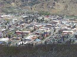
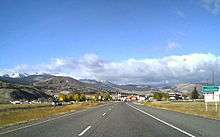
Downtown Anaconda, looking north | |
 Anaconda Location in Montana | |
| Coordinates: 46°8′N 112°56′W / 46.133°N 112.933°WCoordinates: 46°8′N 112°56′W / 46.133°N 112.933°W | |
| Country | United States |
| State | Montana |
| County | Deer Lodge |
| Area | |
| • Total | 741.2 sq mi (1,919.7 km2) |
| • Land | 736.5 sq mi (1,907.6 km2) |
| • Water | 4.7 sq mi (12.1 km2) |
| Elevation | 5,276 ft (1,608 m) |
| Population (2010)[1] | |
| • Total | 9,298 |
| • Estimate (2015)[2] | 9,139 |
| • Density | 13/sq mi (4.9/km2) |
| Time zone | Mountain (MST) (UTC−7) |
| • Summer (DST) | MDT (UTC−6) |
| ZIP code | 59711 |
| FIPS code | 30-01675 |
| GNIS feature ID | 779015 |
| Website |
adlc |
Anaconda, county seat of Anaconda-Deer Lodge County, which has a consolidated city-county government, is located in southwestern Montana of the United States. Located at the foot of the Pintlar Mountains, the Continental Divide passes within 8 mi (13 km) south of the community. As of the 2010 census the population of the consolidated city-county was 9,298, with a per capita personal income of $20,462 and a median household income of $34,716.[3] It had earlier peaks of population in 1930 and 1980, based on the mining industry. It is still the ninth most populous city in Montana. Central Anaconda is 5,335 ft (1,626 m) above sea level, and is surrounded by the communities of Opportunity and West Valley.
The county area is 741 square miles (1,920 km2), characterized by densely timbered forestlands, lakes, mountains and recreation grounds. The county has common borders with Beaverhead, Butte-Silver Bow, Granite, Jefferson and Powell counties.
History

Anaconda was founded by Marcus Daly, one of the Copper Kings, who financed the construction of a smelter on nearby Warm Springs Creek to process copper ore from the Butte mines. In June 1883, Daly filed for a town plat for "Copperopolis", but that name was already used by another mining town in Meagher County. Instead, Daly accepted the name "Anaconda", suggested by the United States postmaster of the time, Clinton Moore. When Montana was admitted as a state in 1889, Daly lobbied to have the capital moved here, but it stayed in Helena, a location supported by rival William Andrews Clark.
In 1903, the Socialist Party of America won its first victory west of the Mississippi when Anaconda voters elected a socialist mayor, treasurer, police judge, and three councilmen. The Socialist Party had grown within the expanding Montana labor movement. Initially, the Anaconda Copper Mining Company tolerated socialist activities, but when the Socialists gained political power and threatened to implement reform, the company systematically undermined the radical party. City workers and councilmen refused to cooperate with the new mayor, and the company began to fire Socialists. In the long run labor lost ground in Anaconda and the company exerted ever greater political control.[4]
The Anaconda Company expanded smelting capacity over time; by 1919 the Washoe Reduction Works could boast that its 585-foot (178 m) smokestack (Anaconda Smelter Stack) was the tallest masonry structure in the world and that the smelter-refining complex constituted the world's largest non-ferrous processing plant.
In 1980, Atlantic Richfield Company closed the smelter, bringing an end to almost a century of mineral processing.[5] While some aspects of the operation had been cleaned up under environmental laws, closing the smelter resulted in a large area contaminated with hazardous wastes. Since then, an operation for environmental cleanup was put into place by the federal Environmental Protection Agency and executed with the assistance of ARCO. The multimillion-dollar cleanup and redevelopment has resulted in the "Old Works" Golf Course, a championship 18-hole course designed by Jack Nicklaus.
Part of Anaconda is included in the Butte-Anaconda Historic District.
Geography
- Elevation: 5335 ft (1,626 m)
- Average annual rainfall: 14 inches (356 mm)
- Average length of growing season: 114 days
- Average annual snowfall: 48.0 inches (122 cm)
- Average annual temperature: 43.0 °F (6.1 °C)
Adjoining counties
Climate
| Climate data for Anaconda | |||||||||||||
|---|---|---|---|---|---|---|---|---|---|---|---|---|---|
| Month | Jan | Feb | Mar | Apr | May | Jun | Jul | Aug | Sep | Oct | Nov | Dec | Year |
| Record high °F (°C) | 60 (16) |
65 (18) |
71 (22) |
83 (28) |
89 (32) |
95 (35) |
100 (38) |
98 (37) |
95 (35) |
88 (31) |
71 (22) |
60 (16) |
100 (38) |
| Average high °F (°C) | 35.2 (1.8) |
39.9 (4.4) |
46.6 (8.1) |
55.3 (12.9) |
64.2 (17.9) |
72.8 (22.7) |
80.4 (26.9) |
80.5 (26.9) |
70.2 (21.2) |
58.4 (14.7) |
42.5 (5.8) |
34.9 (1.6) |
56.74 (13.74) |
| Daily mean °F (°C) | 24.2 (−4.3) |
28.2 (−2.1) |
34.4 (1.3) |
41.8 (5.4) |
50.0 (10) |
57.8 (14.3) |
63.6 (17.6) |
63.4 (17.4) |
54.1 (12.3) |
44.2 (6.8) |
31.3 (−0.4) |
24.0 (−4.4) |
43.08 (6.16) |
| Average low °F (°C) | 13.1 (−10.5) |
16.5 (−8.6) |
22.1 (−5.5) |
28.3 (−2.1) |
35.7 (2.1) |
42.7 (5.9) |
46.8 (8.2) |
46.3 (7.9) |
38.0 (3.3) |
30.0 (−1.1) |
20.1 (−6.6) |
13.1 (−10.5) |
29.39 (−1.46) |
| Record low °F (°C) | −28 (−33) |
−35 (−37) |
−12 (−24) |
4 (−16) |
17 (−8) |
27 (−3) |
30 (−1) |
25 (−4) |
12 (−11) |
−9 (−23) |
−22 (−30) |
−38 (−39) |
−38 (−39) |
| Average precipitation inches (mm) | 0.58 (14.7) |
0.46 (11.7) |
1.04 (26.4) |
1.17 (29.7) |
1.85 (47) |
1.93 (49) |
1.43 (36.3) |
1.47 (37.3) |
1.14 (29) |
0.84 (21.3) |
0.84 (21.3) |
0.63 (16) |
13.38 (339.7) |
| Source #1: NOAA (normals, 1971–2000) [6] | |||||||||||||
| Source #2: The Weather Channel (Records) [7] | |||||||||||||
Demographics
| Historical population | |||
|---|---|---|---|
| Census | Pop. | %± | |
| 1880 | 700 | — | |
| 1890 | 3,975 | 467.9% | |
| 1900 | 9,453 | 137.8% | |
| 1910 | 10,134 | 7.2% | |
| 1920 | 11,668 | 15.1% | |
| 1930 | 12,494 | 7.1% | |
| 1940 | 11,004 | −11.9% | |
| 1950 | 11,254 | 2.3% | |
| 1960 | 12,054 | 7.1% | |
| 1970 | 9,771 | −18.9% | |
| 1980 | 12,518 | 28.1% | |
| 1990 | 10,278 | −17.9% | |
| 2000 | 9,417 | −8.4% | |
| 2010 | 9,298 | −1.3% | |
| Est. 2015 | 9,139 | [8] | −1.7% |
| source:[9] 2015 Estimate[2] | |||
Arts and culture
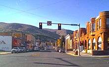
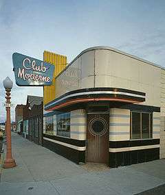
On main street is the Washoe Theater, which is listed on the National Register of Historic Places. It was the last theater constructed in the United States in the Neuvo Deco style. The theater was designed in 1930 by B. Marcus Priteca, an architect from Seattle and opened in 1936. It was listed by the NRHP for architectural significance in 1982. It currently is used for showing films, plus periodically hosting plays and other types of entertainment.
Government and politics
Deer Lodge County voters have a record as the most consistently Democratic county in Montana for Presidential elections. These voters have not supported a Republican candidate since Calvin Coolidge in 1924. In the last five elections, the Democratic candidate has won by 21% to nearly 49% of Deer Lodge County's vote. In gubernatorial elections, the only Republican to carry the county in the last twenty years was Marc Racicot in the 1996 election. In that election the original Democratic nominee, Chet Blaylock, died and Marc Racicot carried every county.
The city is in the 43rd district of the Montana Senate and as such has been represented by Democrat Jesse Laslovich since 2004. In the Montana House of Representatives, it is in the 85th district and has been represented by Democrat Cynthia Hiner since 2004.
As of 2014 the current Chief Executive of Anaconda is Connie Daniels. The County Commission includes Paul Smith, Patricia Mulvey, Elaine Lux-Burt, Kevin Hart, Terry Vermeire. The Clerk and Recorder Administrator is named Joey Blodnick.[10]
Sports and recreation
- Hunting – There are hundreds of square miles of hunting available to the public in the area. With permit, hunting is permitted for fowl, bear, mountain lion, elk, deer and moose. Only deer and elk hunting is allowed without prior application to the state hunting license draw.
- Fishing – Many nearby mountain lakes and streams offer such primary fishing spots as Silver Lake, Georgetown Lake, Echo Lake, Storm Lake, Racetrack Lake, Warm Springs Creek, Warm Springs Ponds, and the Big Hole River.
- Golf – The Old Works Golf Course is a Jack Nicklaus-signature golf course, developed of brownfield land. A local country club and an 18-hole championship golf course are located at Fairmont Hot Springs.
- Skiing – The area has many trails for cross-country skiers, and the nearby Discovery Ski Area has downhill skiing with 15 downhill double-black diamond trails and 5 kilometres (3 mi) of groomed cross-country ski trails.
- Darts -The annual Winter Getaway dart tournament, held in several local establishments, is the largest regional dart tournament in Montana.
- Museums – The Copper Village Museum and Arts Center provides visitors and residents with art and history of the local area.
- Hiking – Hiking opportunities in and around Anaconda include trails up to mountain lakes and a 10,067-foot (3,068 m) mountain that can be climbed without technical equipment. A walking trail is on the north side of Anaconda next to Warm Springs Creek.
- Drag Racing – Lost Creek Raceway was founded in 1986 and hosts over 20 events a year bringing racers from Washington, Idaho and Montana.
- Special Events – There are many special events in Anaconda and near, from season to season.
Education
Five schools are part of Anaconda School District 10, including a Head Start program; W K Dwyer Elementary (grades K–2), Lincoln Elementary (grades 3–5), Fred Moodry Middle School (grades 6–8), and Anaconda High School (grades 9–12). The district has a web site with information about the schools.[11]
Notable people
- Lucille Ball – actress; lived in Anaconda briefly as a child; she was born in Jamestown, New York.
- John H. Collins – classical scholar
- Frank Cope – New York Giants offensive lineman
- Marcus Daly – founder of Anaconda, and one of the "Copper Kings" of Butte
- Lester Dragstedt – first surgeon to successfully separate conjoined twins[12]
- Wayne Estes – college basketball star
- Bert Glennon – cinematographer and director
- Raymond Hunthausen – Roman Catholic Archbishop of Seattle
- Rob Johnson – New York Mets catcher
- Ed Kalafat – NBA Minneapolis Lakers basketball player
- Nancy Keenan – politician, NARAL president
- Hal C. Kern – film editor
- Angela McLean – Lieutenant Governor of Montana
- Milan Lazetich – football player for Los Angeles Rams
- Bill Lazetich – pro football player and older brother of Milan
- George A. Lingo – politician in the Alaska Territory
- Jack Morris, S.J. – born in Anaconda, founded and named the Jesuit Volunteer Corps.[13]
- Casper Oimoen – Olympic ski jumper
- Bill Ray – Alaska businessman, politician, writer
- Michael Sells – Islamic studies expert
- George Leo Thomas – Roman Catholic Bishop of Helena
- Ralph "Papa" Thorson – bounty hunter, subject of The Hunter starring Steve McQueen
- Lester Thurow – economist
- John H. Tolan – U.S. Congressman from California
- Thomas J. Ward – Medal of Honor recipient in the Civil War[14]
See also
References
- ↑ "Geographic Identifiers: 2010 Demographic Profile Data (G001): Anaconda-Deer Lodge County, Montana". U.S. Census Bureau, American Factfinder. Retrieved November 2, 2015.
- 1 2 "Population Estimates". United States Census Bureau. Retrieved July 14, 2016.
- ↑ U.S. Census 2010
- ↑ Jerry Calvert, "The Rise and Fall of Socialism in a Company Town, 1902–1905", Montana, Dec 1986, Vol. 36 Issue 4, pp 2-13
- ↑ Aarstad, Rich, Ellie Arguimbau, Ellen Baumler, Charlene Porsild, and Brian Shovers. Montana Place Names from Alzada to Zortman Archived October 8, 2009, at the Wayback Machine.. Montana Historical Society Press.
- ↑ "Climatography of the United States NO.81" (PDF). National Oceanic and Atmospheric Administration. Retrieved January 15, 2011.
- ↑ "Monthly Averages for Anaconda, MT". The Weather Channel. Retrieved January 15, 2011.
- ↑ "Annual Estimates of the Resident Population for Incorporated Places: April 1, 2010 to July 1, 2015". Retrieved July 2, 2016.
- ↑ Moffatt, Riley. Population History of Western U.S. Cities & Towns, 1850–1990. Lanham: Scarecrow, 1996, 127.
- ↑
- ↑ Anaconda Public Schools
- ↑ Corman, Marvin L. (2005). Colon and Rectal Surgery. Lippincott Williams & Wilkins. p. 1574. ISBN 0781740436. Retrieved May 30, 2015.
- ↑ "Founder of the Jesuit Volunteer Corps movement dies". Catholic Sentinel. 2012-10-02. Retrieved 2012-10-11.
- ↑ "Thomas J. Ward". Retrieved July 1, 2014.
Further reading
- Mercier, Laurie. Anaconda: Labor, Community, and Culture in Montana's Smelter City (University of Illinois Press, 2001) 300pp
External links
| Wikimedia Commons has media related to Anaconda, Montana. |
| Wikivoyage has a travel guide for Anaconda. |
| Wikisource has the text of a 1911 Encyclopædia Britannica article about Anaconda, Montana. |
- City County Website
- Chamber of Commerce
- Clark Fork Watershed Education Program
- Video portrait of Anaconda
-
 "Anaconda, Mont". Encyclopedia Americana. 1920.
Municipalities and communities of Deer Lodge County, Montana, United States | ||
|---|---|---|
| City | 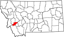 | |
| Unincorporated communities | ||
| Ghost town | ||