Glendive, Montana
| Glendive, Montana | |
|---|---|
| City | |
|
Glendive City Hall | |
| Motto: Good People Surrounded by Badlands | |
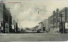
 Location of Glendive, Montana | |
 Glendive, Montana Location in the United States | |
| Coordinates: 47°6′31″N 104°42′38″W / 47.10861°N 104.71056°WCoordinates: 47°6′31″N 104°42′38″W / 47.10861°N 104.71056°W | |
| Country | United States |
| State | Montana |
| County | Dawson |
| Area[1] | |
| • Total | 3.35 sq mi (8.68 km2) |
| • Land | 3.32 sq mi (8.60 km2) |
| • Water | 0.03 sq mi (0.08 km2) |
| Elevation | 2,064 ft (629 m) |
| Population (2010)[2] | |
| • Total | 4,935 |
| • Estimate (2015)[3] | 5,490 |
| • Density | 1,486.4/sq mi (573.9/km2) |
| Time zone | Mountain (MST) (UTC-7) |
| • Summer (DST) | MDT (UTC-6) |
| ZIP code | 59330 |
| Area code(s) | 406 Exchanges: 359,367 |
| FIPS code | 30-31450 |
| GNIS feature ID | 0771800 |
| Website | http://www.glendivechamber.com/ |

Glendive is a city in and the county seat of Dawson County, Montana, United States.[4] Glendive was established by the Northern Pacific Railway when they built the transcontinental railroad across the northern tier of the western United States from Minnesota to the Pacific Coast. The town was the headquarters for the Yellowstone Division that encompassed 875 route miles (1,408 km); 546 (879) in main line and 328 (528) in branches with the main routes from Mandan, North Dakota, to Billings, Montana, and from Billings to Livingston, Montana. The town of Glendive is an agricultural and ranching hub of eastern Montana. The town is tucked between the Yellowstone River and the Badlands, named for the rugged terrain and jagged rock formations that are known to exist in the area. Makoshika State Park is located just east of Glendive.
Glendive is the smallest US television market (or DMA), as identified by Nielsen.[5] The population was 4,935 at the 2010 census.[6]
In January 2015 Glendive was the site of a major oil spill from a pipeline which also contaminated drinking water.[7]
Geography
Glendive is located at 47°6′31″N 104°42′38″W / 47.10861°N 104.71056°W (47.108491, -104.710419),[8] at an altitude of 2,064 feet (629 m).[9]
According to the United States Census Bureau, the city has a total area of 3.35 square miles (8.68 km2), of which 3.32 square miles (8.60 km2) is land and 0.03 square miles (0.08 km2) is water.[1]
Etymology
Sir George Gore, a wealthy Irish sportsman,[10] named his favorite hunting area "Glendive" in 1855, from the Irish gleann 'valley' and dubh 'black'.
Demographics

Glendive was briefly an oil boom town after the discovery of oil in the Williston Basin in the early 1950s. Moving the oil out of the area was difficult and expensive though; the boom ended by 1954 and only a small reserve existed locally. The community has been impacted in the 2000s by the North Dakota oil boom which spurred a modest increase in the population.[7]
| Historical population | |||
|---|---|---|---|
| Census | Pop. | %± | |
| 1880 | 500 | — | |
| 1890 | 720 | 44.0% | |
| 1900 | 1,200 | 66.7% | |
| 1910 | 2,428 | 102.3% | |
| 1920 | 3,816 | 57.2% | |
| 1930 | 4,629 | 21.3% | |
| 1940 | 4,524 | −2.3% | |
| 1950 | 5,254 | 16.1% | |
| 1960 | 7,058 | 34.3% | |
| 1970 | 6,305 | −10.7% | |
| 1980 | 5,978 | −5.2% | |
| 1990 | 4,802 | −19.7% | |
| 2000 | 4,729 | −1.5% | |
| 2010 | 4,935 | 4.4% | |
| Est. 2015 | 5,490 | [11] | 11.2% |
| source:[12] 2015 Estimate[3] | |||
2010 census
As of the census[2] of 2010, there were 4,935 people, 2,060 households, and 1,190 families residing in the city. The population density was 1,486.4 inhabitants per square mile (573.9/km2). There were 2,267 housing units at an average density of 682.8 per square mile (263.6/km2). The racial makeup of the city was 94.4% White, 0.5% African American, 2.4% Native American, 0.4% Asian, 0.1% Pacific Islander, 0.3% from other races, and 1.8% from two or more races. Hispanic or Latino of any race were 2.4% of the population.
There were 2,060 households of which 25.8% had children under the age of 18 living with them, 45.4% were married couples living together, 8.3% had a female householder with no husband present, 4.1% had a male householder with no wife present, and 42.2% were non-families. 37.9% of all households were made up of individuals and 17% had someone living alone who was 65 years of age or older. The average household size was 2.15 and the average family size was 2.84.
The median age in the city was 41.2 years. 19.9% of residents were under the age of 18; 12% were between the ages of 18 and 24; 22.7% were from 25 to 44; 26.5% were from 45 to 64; and 18.8% were 65 years of age or older. The gender makeup of the city was 50.4% male and 49.6% female.
2000 census
As of the census of 2000, there were 4,729 people, 1,983 households, and 1,229 families residing in the city. The population density was 1,419.0 people per square mile (548.3/km²). There were 2,204 housing units at an average density of 661.4 per square mile (255.5/km²). The racial makeup of the city was 97.38% White, 0.30% African American,1.21% Native American, 0.11% Asian, 0.36% from other races, and 0.66% from two or more races. Hispanic or Latino of any race were 1.02% of the population.
There were 1,983 households out of which 27.4% had children under the age of 18 living with them, 50.7% were married couples living together, 8.3% had a female householder with no husband present, and 38.0% were non-families. 34.2% of all households were made up of individuals and 14.9% had someone living alone who was 65 years of age or older. The average household size was 2.22 and the average family size was 2.86.
In the city the population was spread out with 21.7% under the age of 18, 10.6% from 18 to 24, 23.3% from 25 to 44, 23.6% from 45 to 64, and 20.7% who were 65 years of age or older. The median age was 42 years. For every 100 females there were 92.5 males. For every 100 females age 18 and over, there were 91.6 males.
The median income for a household in the city was $30,943, and the median income for a family was $40,313. Males had a median income of $30,977 versus $20,132 for females. The per capita income for the city was $15,544. About 11.6% of families and 14.8% of the population were below the poverty line, including 17.8% of those under age 18 and 10.3% of those age 65 or over.
Radio and television
The Glendive market has three local radio stations:
Glendive is the smallest of the 210 designated markets for broadcast television in the United States as designated by Nielsen Media Research,[5] with one station—KXGN channel 5—carrying a CBS affiliation along with state and local news broadcasts for a small potential audience of several thousand people (county population is 9,059). Until September 2009, KXGN also carried selected prime-time NBC programming in its schedule, making it the last "Big 3" affiliate to offer programming from more than one network on a single feed. In late June 2010, KXGN moved their NBC programming to a DT2 digital subchannel, rejoining the network.
K13PL channel 13, a translator (low-powered rebroadcaster) of Williston, North Dakota's NBC affiliate KUMV was also available until 2013; KUMV is still carried on area cable systems.
Climate
Glendive experiences a semi-arid climate (Köppen BSk) with long, cold, dry winters and hot, wetter summers. Together with Medicine Lake, the town holds the state's all-time-high record of 117 °F (47 °C), which was recorded on July 20, 1893 in Glendive and on July 5, 1937 in Medicine Lake.
| Climate data for Glendive, Montana | |||||||||||||
|---|---|---|---|---|---|---|---|---|---|---|---|---|---|
| Month | Jan | Feb | Mar | Apr | May | Jun | Jul | Aug | Sep | Oct | Nov | Dec | Year |
| Record high °F (°C) | 64 (18) |
73 (23) |
85 (29) |
94 (34) |
104 (40) |
110 (43) |
117 (47) |
113 (45) |
106 (41) |
95 (35) |
80 (27) |
72 (22) |
117 (47) |
| Average high °F (°C) | 25.3 (−3.7) |
33.7 (0.9) |
44.9 (7.2) |
58.9 (14.9) |
70.4 (21.3) |
80.2 (26.8) |
87.3 (30.7) |
87.0 (30.6) |
74.4 (23.6) |
61.2 (16.2) |
41.0 (5) |
29.3 (−1.5) |
57.8 (14.33) |
| Daily mean °F (°C) | 14.5 (−9.7) |
22.2 (−5.4) |
32.6 (0.3) |
45.3 (7.4) |
57.1 (13.9) |
66.8 (19.3) |
72.8 (22.7) |
71.5 (21.9) |
59.4 (15.2) |
47.5 (8.6) |
30.6 (−0.8) |
19.0 (−7.2) |
44.94 (7.18) |
| Average low °F (°C) | 3.6 (−15.8) |
10.7 (−11.8) |
20.2 (−6.6) |
31.7 (−0.2) |
43.7 (6.5) |
53.3 (11.8) |
58.3 (14.6) |
55.9 (13.3) |
44.4 (6.9) |
33.7 (0.9) |
20.2 (−6.6) |
8.7 (−12.9) |
32.03 (0.01) |
| Record low °F (°C) | −48 (−44) |
−50 (−46) |
−30 (−34) |
−6 (−21) |
16 (−9) |
29 (−2) |
37 (3) |
32 (0) |
14 (−10) |
−13 (−25) |
−27 (−33) |
−42 (−41) |
−50 (−46) |
| Average precipitation inches (mm) | 0.41 (10.4) |
0.33 (8.4) |
0.57 (14.5) |
1.17 (29.7) |
2.08 (52.8) |
2.50 (63.5) |
1.80 (45.7) |
1.44 (36.6) |
1.43 (36.3) |
1.00 (25.4) |
0.49 (12.4) |
0.40 (10.2) |
13.62 (345.9) |
| Source #1: NOAA (normals, 1971–2000) [14] | |||||||||||||
| Source #2: The Weather Channel (Records) [15] | |||||||||||||
Notable people
- Tim M. Babcock, 16th Governor of Montana, grew up on a ranch and later a house in Glendive, graduate of Dawson County High School in Glendive
- Kamran Ince, Turkish-American music composer.
- Clyde Lamb, cartoonist
- Adam Morrison, professional basketball player
- John Patton, Wyoming state legislator
- Alfred E. Perlman, President, New York Central Railroad, President Western Pacific Railroad
- Mike Person, offensive lineman for the Kansas City Chiefs.
- Joyce Woodhouse, Democratic member of the Nevada Senate.
- Hank Worden, born Norton Earl Worden, cowboy actor
References
"A Guide to Historic Glendive" Montana Historical Society (1998)
Notes
- 1 2 "US Gazetteer files 2010". United States Census Bureau. Archived from the original on January 24, 2012. Retrieved 2012-12-18.
- 1 2 "American FactFinder". United States Census Bureau. Retrieved 2012-12-18.
- 1 2 "Population Estimates". United States Census Bureau. Retrieved July 14, 2016.
- ↑ "Find a County". National Association of Counties. Archived from the original on May 31, 2011. Retrieved 2011-06-07.
- 1 2 "U.S. Local TV Market Rankings As of September 27, 2014" (PDF). The Nielsen Company.
- ↑ "2010 Census Redistricting Data (Public Law 94-171) Summary File". American FactFinder. United States Census Bureau. Archived from the original on July 21, 2011. Retrieved 2 May 2011.
- 1 2 Muskal, Michael (January 20, 2015) "Water supply off-limits in Montana town after Yellowstone River oil spill" Los Angeles Times
- ↑ "US Gazetteer files: 2010, 2000, and 1990". United States Census Bureau. 2011-02-12. Retrieved 2011-04-23.
- ↑ U.S. Geological Survey Geographic Names Information System: Glendive, Montana
- ↑ "The Glendive, MT Historical Marker" Montana Historical Markers Waymarking.com
- ↑ "Annual Estimates of the Resident Population for Incorporated Places: April 1, 2010 to July 1, 2015". Retrieved July 2, 2016.
- ↑ Moffatt, Riley. Population History of Western U.S. Cities & Towns, 1850-1990. Lanham: Scarecrow, 1996, 131.
- ↑ United States Census Bureau. "Census of Population and Housing". Archived from the original on May 11, 2015. Retrieved August 14, 2013.
- ↑ "Climatography of the United States NO.81" (PDF). National Oceanic and Atmospheric Administration. Retrieved January 15, 2011.
- ↑ "Monthly Averages for Glendive, MT". The Weather Channel. Retrieved January 15, 2011.
External links
| Wikimedia Commons has media related to Glendive, Montana. |
| Wikivoyage has a travel guide for Glendive. |
Municipalities and communities of Dawson County, Montana, United States | ||
|---|---|---|
| City | 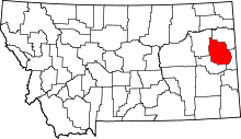 | |
| Town | ||
| CDP | ||
| Unincorporated communities | ||