Miles City, Montana
| Miles City, Montana | |
|---|---|
| City | |
|
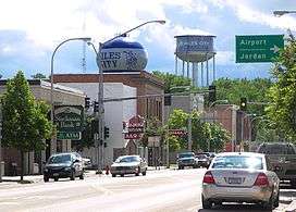
Main Street in Miles City | |
 Location of Miles City, Montana | |
| Coordinates: 46°24′30″N 105°50′24″W / 46.40833°N 105.84000°WCoordinates: 46°24′30″N 105°50′24″W / 46.40833°N 105.84000°W | |
| Country | United States |
| State | Montana |
| County | Custer |
| Government | |
| • Mayor | John Hollowell |
| Area[1] | |
| • Total | 3.34 sq mi (8.65 km2) |
| • Land | 3.34 sq mi (8.65 km2) |
| • Water | 0 sq mi (0 km2) |
| Elevation | 2,369 ft (722 m) |
| Population (2010)[2] | |
| • Total | 8,410 |
| • Estimate (2015)[3] | 8,796 |
| • Density | 2,518.0/sq mi (972.2/km2) |
| Time zone | Mountain (MST) (UTC-7) |
| • Summer (DST) | MDT (UTC-6) |
| ZIP code | 59301 |
| Area code(s) | 406 |
| FIPS code | 30-49525 |
| GNIS feature ID | 0774202 |
| Website | http://www.milescitychamber.com/ |
Miles City is a city in and the county seat of Custer County, Montana, United States.[4] The population was 8,410 at the 2010 census.
History
After the Battle of the Little Bighorn in 1876, the U.S. Army created forts in eastern Montana, including one where the north-flowing Tongue River flowed into the east-flowing Yellowstone River. The first fort was known as the Tongue River Cantonment or the Tongue River Barracks and was founded on August 27, 1876. A second, permanent fort was constructed on higher ground two miles to the west of the mouth of the Tongue and this became Fort Keogh.
Fort Keogh (named after Captain Myles Keogh, one of the battle dead, whose horse, Comanche, was the lone survivor of Custer's command) started as a few rough winter cabins, but grew into a moderate sized western fort, from which its commander, General Nelson A. Miles, effectively brought the remaining "uncontrolled" Native Americans into subjugation during the last decade of the 1800s.[5]
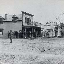
Nelson Miles said that "whiskey caused him more trouble than the Indians" and, after tiring of drunken soldiers causing problems during the winter campaign, evicted the sutlers who provided "liquid stock" in the spring of 1877. Moving two miles due east of the Tongue River Cantonment, these early merchants founded the first Miles City. Although fondly referred to as "Milestown," the first post office and first official plat both called the town "Miles City." When the old cantonment moved two miles west, the town literally picked up and followed, moving to the current site. The last occupants of Old Miles City stayed on until 1900 but the new community was the one that grew.
Before the town itself was founded, George Miles, the nephew of General Miles, who had accompanied his uncle on the western expedition and served in the quartermasters office, bought a herd of sheep, the first of many commercial enterprises in his involvement with the core founders of the town.
Livestock speculation brought thousands of cattle to the open ranges in the late 1880s, the railroad was extended through the area, and Texas drove numerous cattle to Miles City to fatten them on free grass and move them to where they could be loaded on trains bound for the slaughterhouses in Chicago.
Miles City established a municipal electric utility around 1887 and it was a source of civic pride (as any city would have towards its own utilities) until a traveling employee of Minnesota Northern Power (predecessor of MDU Resources Group, Inc.) told the city council "the emperor has no clothes;" i.e., the system was far less efficient and in worse shape than they thought. The city council eventually put the question to the voters who instructed the city to sell the utility. By this time, the people with the Montana Power Company (now NorthWestern Energy's Montana division) became aware of this and were soon locked in an epic battle with Minnesota Northern over the franchise. A franchise election was held to determine who would serve Miles City on June 28, 1927. Minnesota Northern won by a scant 16 votes.
Miles City experienced rapid growth until the 1920s and 1930s, but became overshadowed by the upstart upriver town of Billings, which was at the cross roads of transportation routes, and it became a banking center, oil refining center, and medical service center and is now the largest city in the state.
The publicly owned Miles City Municipal Airport is located less than two miles (3 km) from town. Notably, it was the site of an early scheduled airline crash, involving Northwest Airlines Flight 1, which caught fire and crashed shortly after takeoff in January, 1939.
Geography and climate
Miles City is located at 46°24′30″N 105°50′24″W / 46.40833°N 105.84000°W (46.408460, -105.840093),[6] at an altitude of 2369 feet (722 m).[7]
According to the United States Census Bureau, the city has a total area of 3.34 square miles (8.65 km2), all land.[1]
Miles City experiences a semi-arid climate (Köppen BSk) with long, cold, dry winters and hot, wetter summers. The city holds the record for the highest mean sea level pressure in the contiguous United States with a reading of 31.42 inHg (1064 mb) on December 24, 1983.[8]
| Climate data for Miles City Airport | |||||||||||||
|---|---|---|---|---|---|---|---|---|---|---|---|---|---|
| Month | Jan | Feb | Mar | Apr | May | Jun | Jul | Aug | Sep | Oct | Nov | Dec | Year |
| Record high °F (°C) | 72 (22) |
73 (23) |
83 (28) |
92 (33) |
100 (38) |
106 (41) |
113 (45) |
110 (43) |
106 (41) |
95 (35) |
81 (27) |
69 (21) |
113 (45) |
| Average high °F (°C) | 27.3 (−2.6) |
35.2 (1.8) |
46.1 (7.8) |
58.8 (14.9) |
69.5 (20.8) |
79.9 (26.6) |
87.9 (31.1) |
86.8 (30.4) |
74.0 (23.3) |
60.0 (15.6) |
41.8 (5.4) |
30.6 (−0.8) |
58.2 (14.6) |
| Average low °F (°C) | 7.4 (−13.7) |
14.3 (−9.8) |
23.7 (−4.6) |
34.5 (1.4) |
44.9 (7.2) |
54.2 (12.3) |
60.2 (15.7) |
58.9 (14.9) |
46.8 (8.2) |
35.3 (1.8) |
21.6 (−5.8) |
10.5 (−11.9) |
34.4 (1.3) |
| Record low °F (°C) | −37 (−38) |
−37 (−38) |
−28 (−33) |
5 (−15) |
15 (−9) |
32 (0) |
41 (5) |
35 (2) |
19 (−7) |
−8 (−22) |
−27 (−33) |
−38 (−39) |
−38 (−39) |
| Average precipitation inches (mm) | .50 (12.7) |
.34 (8.6) |
.58 (14.7) |
1.40 (35.6) |
2.19 (55.6) |
2.42 (61.5) |
1.61 (40.9) |
1.16 (29.5) |
1.19 (30.2) |
1.13 (28.7) |
.52 (13.2) |
.45 (11.4) |
13.49 (342.6) |
| Average snowfall inches (cm) | 5.3 (13.5) |
3.5 (8.9) |
4.2 (10.7) |
3.5 (8.9) |
1.0 (2.5) |
trace | 0 (0) |
0 (0) |
.4 (1) |
1.3 (3.3) |
3.6 (9.1) |
4.5 (11.4) |
27.3 (69.3) |
| Average precipitation days (≥ 0.01 in) | 7.3 | 5.8 | 7.3 | 7.9 | 10.9 | 10.4 | 7.7 | 6.4 | 6.4 | 6.2 | 6.0 | 7.0 | 89.3 |
| Average snowy days (≥ 0.1 in) | 6.0 | 4.6 | 4.5 | 1.7 | .5 | 0 | 0 | 0 | .2 | .9 | 3.5 | 5.8 | 27.7 |
| Source #1: NOAA (normals, 1971−2000) [9] | |||||||||||||
| Source #2: Weather.com (Records) [10] | |||||||||||||
Giant snowflake
Guinness World Records reports that the largest natural snowflake ever measured, 15 inches (38 cm) in diameter, was recorded at Fort Keogh on 28 January 1887. However, there is no corroborating evidence to support this claim.[11]
Demographics
| Historical population | |||
|---|---|---|---|
| Census | Pop. | %± | |
| 1880 | 629 | — | |
| 1890 | 956 | 52.0% | |
| 1900 | 1,938 | 102.7% | |
| 1910 | 4,697 | 142.4% | |
| 1920 | 7,937 | 69.0% | |
| 1930 | 7,175 | −9.6% | |
| 1940 | 7,313 | 1.9% | |
| 1950 | 9,243 | 26.4% | |
| 1960 | 9,665 | 4.6% | |
| 1970 | 9,023 | −6.6% | |
| 1980 | 9,602 | 6.4% | |
| 1990 | 8,461 | −11.9% | |
| 2000 | 8,487 | 0.3% | |
| 2010 | 8,410 | −0.9% | |
| Est. 2015 | 8,796 | [12] | 4.6% |
| U.S. Decennial Census[13] 2015 Estimate[3] | |||
2010 census
As of the census[2] of 2010, there were 8,410 people, 3,677 households, and 2,082 families residing in the city. The population density was 2,518.0 inhabitants per square mile (972.2/km2). There were 4,000 housing units at an average density of 1,197.6 per square mile (462.4/km2). The racial makeup of the city was 95.3% White, 0.3% African American, 1.7% Native American, 0.4% Asian, 0.1% Pacific Islander, 0.6% from other races, and 1.6% from two or more races. Hispanic or Latino of any race were 2.4% of the population.
There were 3,677 households of which 27.5% had children under the age of 18 living with them, 42.0% were married couples living together, 10.3% had a female householder with no husband present, 4.3% had a male householder with no wife present, and 43.4% were non-families. 37.2% of all households were made up of individuals and 15% had someone living alone who was 65 years of age or older. The average household size was 2.20 and the average family size was 2.89.
The median age in the city was 40.6 years. 22.4% of residents were under the age of 18; 9.4% were between the ages of 18 and 24; 22.7% were from 25 to 44; 27.6% were from 45 to 64; and 17.8% were 65 years of age or older. The gender makeup of the city was 48.8% male and 51.2% female.
2000 census
As of the census of 2000, there were 8,487 people, 3,528 households, and 2,194 families residing in the city. The population density was 2,593.3 people per square mile (1,002.1/km²). There were 3,890 housing units at an average density of 1,188.7 per square mile (459.3/km²). The racial makeup of the city was 96.72% White, 0.12% African American, 1.39% Native American, 0.28% Asian, 0.05% Pacific Islander, 0.44% from other races, and 1.00% from two or more races. Hispanic or Latino of any race were 1.59% of the population.
There were 3,528 households out of which 29.7% had children under the age of 18 living with them, 47.7% were married couples living together, 10.8% had a female householder with no husband present, and 37.8% were non-families. 32.3% of all households were made up of individuals and 13.1% had someone living alone who was 65 years of age or older. The average household size was 2.31 and the average family size was 2.93.
In the city the population was spread out with 24.6% under the age of 18, 8.8% from 18 to 24, 25.9% from 25 to 44, 22.5% from 45 to 64, and 18.2% who were 65 years of age or older. The median age was 39 years. For every 100 females there were 92.3 males. For every 100 females age 18 and over, there were 87.7 males.
The median income for a household in the city was $29,847, and the median income for a family was $41,190. Males had a median income of $30,123 versus $18,750 for females. The per capita income for the city was $16,449. About 9.4% of families and 14.7% of the population were below the poverty line, including 17.7% of those under age 18 and 8.5% of those age 65 or over.
Radio stations
|
Events
The largest event of the year is the Miles City Bucking Horse Sale held in May. Miles City is also home to the Eastern Montana Fair and is the commercial hub of southeastern Montana.[14] The sale is generally held regardless of weather.[15][16]
Education
Miles Community College was founded in 1939. The current average student to faculty ratio is 11:1; class sizes range from 8 to 50 students; and over 85% of the students qualify for financial aid. Miles Community College also features free tutoring at the Center for Academic Success. The Judson H. Flower, Jr. Library is located within the main building of Miles Community College, and is equipped with computer lab and INFOTRAC.
Custer County District High School is the only high school in the entire county; some students drive as many as 60 miles (97 km) to school. Much of the population's livelihood involves agriculture - entirely or in part; therefore, the National FFA Organization (Future Farmers of America) organization is very active and about 20% of the student population belong to it. The school is famous for its Chorale, which travels extensively including a trip to Carnegie Hall in NYC in 2005 and a trip to Washington D.C. in 2007. The school boasts that its seniors have an average ACT score of 23 and that 57% of the graduating seniors go on to complete their education at a 4-year university.
Miles City also has 4 elementary schools, Lincoln (4-6), Highland Park (k-3), Jefferson (k-3), Garfield (k-6) and a middle school, Washington School (7 and 8). Washington Middle School boasts many extra curricular activities, including sports, builder's club and student council. There is also one parochial school, Sacred Heart (pre K-8).
Places of interest
Woodruff Park provides picnic opportunities in the Pine Hills east of town on the road to Baker (Hwy 12). Spotted Eagle recreation area provides picnic, fishing, swimming, and hiking. Also on the Baker road, but much closer to town, just past the Interstate, are the Strawberry Hills, good for short hikes and climbs. The highest point in the vicinity is Signal Butte (3,051 feet / 929.94 meters above sea level), said to have been used by Native Americans for communication, but used for decades by radio and sometimes TV antennas. Signal Butte lies at the edge of an area of badlands, a striking arid vista of eroded sedimentary soil, sporting multi-colored layers exposed by the erosion. The land contains sandstone formations in the midst of sagebrush and cedar trees growing in a soil that turns to gumbo when wet. Airport Hill is the elevated bluff of the north bank of the Yellowstone River, and Paragon Pit is a remote area of the north bank opposite of Fort Keogh frequented by teenagers over the years. 12 Mile Dam spans the Tongue River and attracts teens in the summer for water sport. Being shallow, the Tongue River is often used for tubing. The former Fort Keogh once boasted an Air Force radar station and still houses a state Extension Experiment Station. Across the highway is the site of a state fish hatchery, and nearby, a double humped butte is known locally as "Camelback". Miles City lies at the mouth of the north flowing Tongue River as it empties into the eastward flowing Yellowstone River. Both rivers are fished regularly, but yield mostly catfish, carp and a junk fish known locally as "shiners". Many local reservoirs are stocked with edible fish from the hatchery in Miles City.
Notable people

- Merle Greene Robertson born in Miles City in 1913, a noted art historian and renowned scholar of the pre-Columbian Maya civilization.
- Walter A. Burleigh, non-voting delegate to the United States House of Representatives from the Dakota Territory
- Emily Danforth, professor and author of The Miseducation of Cameron Post, a coming-of-age story set in Miles City.[17]
- Maurice Hilleman, a noted microbiologist, was born near Miles City in 1919. Hilleman specialized in vaccinology and developed more than three dozen vaccines, including those for measles, mumps, hepatitis A, hepatitis B, chickenpox, meningitis, and pneumonia.
- Elmer Holt - tenth Governor of Montana[18]
- George Lynch, race car driver, was born here.
- Curt Schmidt, Montreal Expos pitcher, was born here.
- James Arnold von der Heydt, (1919-2013) was an American lawyer and judge. He was a member of the United States District Court for the District of Alaska and was born here.[19]
- George Winston, noted American pianist, grew up in Miles City and studied piano at a local conservatory
- Larry R. Williams, World-famous commodity trader, author and father of Academy Award-nominated actress, Michelle Williams, was born in Miles City.
- Jeff Meyer, Television Director, Born and educated in Miles City, son of Coleman and Shirley (Gundlach) Meyer.
References
- 1 2 "US Gazetteer files 2010". United States Census Bureau. Retrieved 2012-12-18.
- 1 2 "American FactFinder". United States Census Bureau. Retrieved 2012-12-18.
- 1 2 "Population Estimates". United States Census Bureau. Retrieved July 14, 2016.
- ↑ "Find a County". National Association of Counties. Retrieved 2011-06-07.
- ↑ "Hero's Bronze Star Shows Up 26 Years Late". The News Tribune. 1995-05-29.
The town, whose radio station has the call letters KATL, was named after US soldier Nelson Appleton Miles, who forced the surrender of Geronimo and the Nez Perce.
- ↑ "US Gazetteer files: 2010, 2000, and 1990". United States Census Bureau. 2011-02-12. Retrieved 2011-04-23.
- ↑ U.S. Geological Survey Geographic Names Information System: Miles City, Montana
- ↑ World and US High Barometric Pressure records
- ↑ "Climatography of the United States No. 20 1971−2000: MILES CITY AP, MT" (PDF). National Oceanic and Atmospheric Administration. Retrieved 2011-01-26.
- ↑ "Monthly Averages for Miles City, MT". The Weather Channel. Retrieved 2011-01-15.
- ↑ New York Times, March 20, 2007, Science, Snowflakes as Big as Frisbees? by William J Broad
- ↑ "Annual Estimates of the Resident Population for Incorporated Places: April 1, 2010 to July 1, 2015". Retrieved July 2, 2016.
- ↑ United States Census Bureau. "Census of Population and Housing". Retrieved August 13, 2013.
- ↑ Patterson, Caroline (1999-05-01). "Getting your buck's worth in Montana". Sunset.
Miles City, MT, is known as the Cow Capital of the West with pickups and stock trucks lining up the streets. The city's cowboy tradition lives through the annual Bucking Horse Sale highlighted by bareback riding events at the Eastern Montana Fairgrounds.
- ↑ "Rain wipes out Miles City racing". Billings Gazette. May 20, 2011. Retrieved June 26, 2011.
- ↑ "Bareback riders showcase the best bucking broncos". CBS Sunday Morning. Retrieved July 3, 2011.
- ↑ Sittenfeld, Curtis (February 8, 2012). "The Best Novel About a "De-Gaying Camp" Ever Written". Slate.
- ↑ "Montana Governor William Elmer Holt". National Governors Association. Retrieved October 10, 2012.
- ↑ 100 Years of Alaska's Legislature A. Von James
External links
| Wikimedia Commons has media related to Miles City, Montana. |
| Wikivoyage has a travel guide for Miles City. |
Municipalities and communities of Custer County, Montana, United States | ||
|---|---|---|
| City | 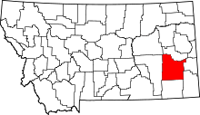 | |
| Town | ||
| Unincorporated communities | ||