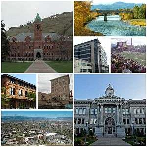
Missoula, Montana
| Missoula, Montana | ||
|---|---|---|
| City | ||
| City of Missoula | ||
|
Missoula, Montana | ||
| ||
| Nickname(s): The Garden City[1] | ||
| Motto: "The Discovery Continues"[1] | ||
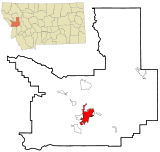 Location of Missoula in Missoula County and Montana | ||
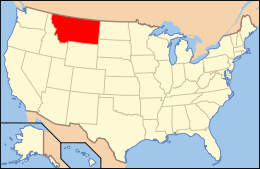 Location of Montana | ||
| Coordinates: 46°51′45″N 114°0′42″W / 46.86250°N 114.01167°WCoordinates: 46°51′45″N 114°0′42″W / 46.86250°N 114.01167°W | ||
| Country | United States | |
| State | Montana | |
| County | Missoula | |
| Founded | 1866 | |
| Incorporated (town) | March 8, 1883 | |
| Incorporated (city) | March 12, 1885 | |
| Founded by | ||
| Government | ||
| • Type | Mayor–Council | |
| • Body | Missoula City Council | |
| • Mayor | John Engen (D) | |
| Area[2][3][4] | ||
| • City | 29.08 sq mi (75.3 km2) | |
| • Land | 28.90 sq mi (74.9 km2) | |
| • Water | 0.184 sq mi (0.48 km2) | |
| • Urban | 45.43 sq mi (117.7 km2) | |
| • Metro | 2,618 sq mi (6,780 km2) | |
| Elevation | 3,209 ft (978 m) | |
| Population (2010)[5] | ||
| • City | 66,788 | |
| • Estimate (2015)[6] | 71,022 | |
| • Rank | US: 494th | |
| • Density | 2,416/sq mi (932.8/km2) | |
| • Metro | 114,181 (US: 336th) | |
| Time zone | Mountain (UTC-7) | |
| • Summer (DST) | Mountain (UTC-6) | |
| ZIP code | 59801–59804, 59806–59808[7] | |
| University of Montana ZIP code | 59812[7] | |
| Area code | 406 | |
| FIPS code | 30-50200 | |
| GNIS feature ID | 0787504 | |
| Highways |
| |
| Website | ci.missoula.mt.us | |
Missoula ![]() i/mᵻˈzuːlə/ is a city in the U.S. state of Montana and is the county seat of Missoula County. It is located along the Clark Fork River near its confluences with the Bitterroot and Blackfoot Rivers in western Montana and at the convergence of five mountain ranges, thus is often described as the "hub of five valleys".[8] In 2015, the United States Census Bureau estimated the city's population at 71,022[9] and the population of the Missoula Metropolitan Area at 114,181.[10] In the 1990s, Missoula overtook Great Falls as Montana’s second‑largest city, behind Billings.[11] Missoula is home to the University of Montana, a public research university.
i/mᵻˈzuːlə/ is a city in the U.S. state of Montana and is the county seat of Missoula County. It is located along the Clark Fork River near its confluences with the Bitterroot and Blackfoot Rivers in western Montana and at the convergence of five mountain ranges, thus is often described as the "hub of five valleys".[8] In 2015, the United States Census Bureau estimated the city's population at 71,022[9] and the population of the Missoula Metropolitan Area at 114,181.[10] In the 1990s, Missoula overtook Great Falls as Montana’s second‑largest city, behind Billings.[11] Missoula is home to the University of Montana, a public research university.
Missoula was founded in 1860 as Hellgate Trading Post while still part of Washington Territory. By 1866, the settlement had moved east, 5 miles (8 km) upstream, and renamed Missoula Mills, later shortened to Missoula.[12] The mills provided supplies to western settlers traveling along the Mullan Road. The establishment of Fort Missoula in 1877 to protect settlers further stabilized the economy. The arrival of the Northern Pacific Railway in 1883 brought rapid growth and the maturation of the local lumber industry. In 1893, the Montana Legislature chose the city as the site for the state's first university. Along with the U.S. Forest Service headquarters founded in 1908, lumber and the university remained staples of the local economy for the next hundred years.[13]
By the 1990s, Missoula's lumber industry had gradually disappeared, and as of 2009, the city's largest employers were the University of Montana, Missoula County Public Schools, and Missoula's two hospitals.[14] The city is governed by a mayor–council government with twelve city council members, two from each of the six wards. In and around Missoula are 400 acres (160 ha) of parkland, 22 miles (35 km) of trails, and nearly 5,000 acres (2,000 ha) of open-space conservation land with adjacent Mount Jumbo home to grazing elk and mule deer during the winter.[15] The city is also home to both Montana's largest and its oldest active breweries as well as the Montana Grizzlies, one of the strongest college football programs in the Division I Football Championship Subdivision of the National Collegiate Athletic Association (NCAA). Notable residents include the first woman in the U.S. Congress, Jeannette Rankin,[16] and the United States' longest-serving Senate Majority Leader, Mike Mansfield.[17]
History
Archaeological artifacts date the Missoula Valley's earliest inhabitants to the end of the last ice age 12,000 years ago with settlements as early as 3500 BCE. From the 1700s until European settlements began a hundred years later, it was primarily the Salish, Kootenai, Pend d'Oreille, Blackfeet, and Shoshone who used the land. Located at the confluence of five mountain valleys, the Missoula Valley was heavily traversed by local and distant native tribes that periodically went to the Eastern Montana plains in search of bison, leading to conflict. The narrow valley at Missoula's eastern entrance was so strewn with human bones from repeated ambushes that French fur trappers would later refer to this area as Porte de l'Enfer, translated as "Gate of Hell".[18] Hell Gate would remain the name of the area until it was renamed "Missoula" in 1866.[12]
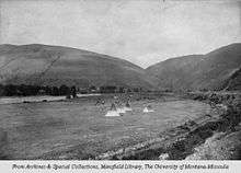
The Lewis and Clark Expedition brought the first U.S. citizens to the area. They twice stopped just south of Missoula at Traveler's Rest.[19][20] They camped there the first time on their westbound trip in September 1805. When they stayed there again on their return in June–July 1806, Clark left heading south along the Bitterroot River and Lewis traveled north, then east, through Hellgate Canyon. In 1860, Hell Gate Village was established 5 miles (8 km) west of present-day downtown by Christopher P. Higgins and Frank Worden as a trading post to serve travelers on the recently completed Mullan Road, the first wagon road to cross the Rocky Mountains to the inland of the Pacific Northwest.[12] The desire for a more convenient water supply to power a lumber and flour mill led to the movement of the settlement to its modern location in 1864.[21]
The Missoula Mills replaced Hell Gate Village as the economic power of the valley and replaced it as the county seat in 1866. The name "Missoula" came from the Salish name for the Clark Fork River, "nmesuletkw", which roughly translates as "place of frozen water".[22] Fort Missoula was established in 1877 to help protect further arriving settlers. Growth accelerated with the arrival of the Northern Pacific Railway in 1883, and the Town of Missoula was chartered the same year.[23] In 1893, Missoula was chosen as the location of the state's first university, the University of Montana. The need for lumber for the railway and its bridges spurred the opening of multiple saw mills in the area and, in turn, the beginning of Missoula's lumber industry, which remained the mainstay of the area's economy for the next hundred years.[13] The continued economic windfall from railroad construction and lumber mills led to a further boom in Missoula's population. A. B. Hammond and Copper Kings Marcus Daly and William A. Clark competed fiercely in the region over lumber share and Missoula investments. The United States Forest Service work in Missoula began in 1905.[24] Missoula is also home of the smokejumpers' headquarters and will be the site of the National Museum of Forest Service History.[24] Nationally, there are nine Forest Service regions; Region 1 is headquartered in Missoula.[25]
.jpg)
Logging remained a mainstay of industry in Missoula with the groundbreaking of the Hoerner-Waldorf pulp mill in 1956, which resulted in protests over the resultant air pollution.[26] An article in Life magazine thirteen years later speaks of Missoulians sometimes needing to drive with headlights on during the day to navigate through the smog.[27] In 1979, still almost 40% of the county's labor income came from the wood and paper products sector.[28] The lumber industry was hit hard by the recession of the early 1980s, and Missoula's economy began to diversify.[29] By the early 1990s, the disappearance of many of the region's log yards, along with legislation, had helped clean the skies dramatically.[30]
As of 2009, education and healthcare were Missoula's leading industries; the University of Montana, Missoula County Public Schools, and the city's two hospitals were the largest employers.[14] St. Patrick Hospital and Health Sciences Center, founded in 1873, is the region's only Level II trauma center and has undergone three major expansions since the 1980s.[31] Likewise, the University of Montana grew 50% and built or renovated 20 buildings from 1990–2010.[32] It is expected that these industries as well as expansions in business and professional services, and retail will be the main engines of future growth.[33]
Geography
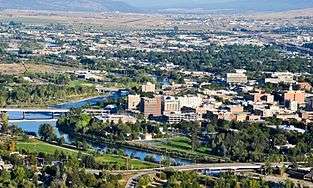
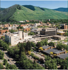
Missoula is located at the western edge of Montana approximately 45 miles (70 km) from the Idaho border. The city is at an elevation of 3,209 feet (978 m) above sea level, with nearby Mount Sentinel and Mount Jumbo steeply rising to 5,158 feet (1,572 m) and 4,768 feet (1,453 m) respectively. According to the Census Bureau's 2015 figures, the city had a total area of 29.08 square miles (75.3 km2), of which, 28.90 square miles (74.9 km2) was land and 0.184 square miles (0.48 km2) was water.[2]
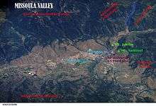
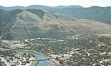
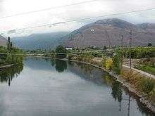
Approximately 13,000 years ago, the entire valley was at the bottom of Glacial Lake Missoula and as could be expected for a former lake bottom, the layout of Missoula is relatively flat and surrounded by steep hills. Evidence of the city of Missoula's lake-bottom past can be seen in the form of ancient horizontal wave-cut shorelines on nearby Mount Sentinel and Mount Jumbo.[34] At the location of present-day University of Montana, the lake once had a depth of 950 feet (290 m).[35] The Clark Fork River enters the Missoula Valley from the east through Hellgate Canyon after joining the nearby Blackfoot River at the site of the former Milltown Dam. The Bitterroot River and multiple smaller tributaries join the Clark Fork on the western edge of Missoula. The city also sits at the convergence of five mountain ranges: the Bitterroot Mountains, Sapphire Range, Garnet Range, Rattlesnake Mountains, and the Reservation Divide, thus is often described as being the "hub of five valleys".[8]
Flora and fauna
Located in the Northern Rockies, Missoula has a typical Rocky Mountain ecology. Local wildlife includes populations of white-tailed deer, black bears, osprey, and bald eagles. During the winter, rapid snowmelt on Mount Jumbo due to its steep slope leaves grass available for grazing elk and mule deer. The rivers around Missoula provide nesting habitats for bank swallows, northern rough-winged swallows and belted kingfishers. Killdeer and spotted sandpipers can be seen foraging for insects along the gravel bars. Other species include song sparrows, catbirds, several species of warblers, and the pileated woodpecker. The rivers also provide cold, clean water for native fish such as westslope cutthroat trout and bull trout. The meandering streams also attract beaver and wood ducks.[36] The parks also host a variety of snakes such as racers, garter snakes, and rubber boa.
Native riparian plant life includes sandbar willows and cottonwoods with Montana's state tree, the ponderosa pine, also being prevalent. Other native plants include wetland species such as cattails and beaked-sedge as well as shrubs and berry plants like Douglas hawthorn, chokecherry, and western snowberries.[36] To the chagrin of local farmers, Missoula is also home to several noxious weeds, which multiple programs have set out to eliminate. Notable ones include Dalmatian toadflax, spotted knapweed, leafy spurge, St. John's wort, and sulfur cinquefoil.[37] Controversially, the Norway maples that line many of Missoula's older streets have also been declared an invasive species.[38]
Climate
Missoula has a semi-arid climate (Köppen climate classification BSk), with cold and moderately snowy winters, hot and dry summers, and short, crisp springs and autumns. Winters are usually milder than much of the rest of the state due to its location west of the Rockies, allowing it to be influenced more by mild, moist Pacific air and avoiding the worst of cold snaps; however, this means precipitation is not at a strong minimum during winter. Winter snowfall averages 39.5 inches (100 cm), on average occurring between October 30 and April 20. As with the rest of the state, summers are very sunny, and the average diurnal temperature variation is more than 30 °F (17 °C) from late June through late September, due to the relative aridity.[39][40] The monthly daily average temperature ranges from 23.9 °F (−4.5 °C) in December to 68.6 °F (20.3 °C) in July. There is an average of 24 days with temperatures above 90 °F (32 °C), 45 days where the temperature does not rise above freezing, and 7.8 days with temperatures below 0 °F (−18 °C).
| Climate data for Missoula, Montana (Missoula Airport) 1981–2010 normals | |||||||||||||
|---|---|---|---|---|---|---|---|---|---|---|---|---|---|
| Month | Jan | Feb | Mar | Apr | May | Jun | Jul | Aug | Sep | Oct | Nov | Dec | Year |
| Record high °F (°C) | 60 (16) |
66 (19) |
78 (26) |
90 (32) |
95 (35) |
102 (39) |
107 (42) |
105 (41) |
99 (37) |
85 (29) |
73 (23) |
60 (16) |
107 (42) |
| Average high °F (°C) | 33.2 (0.7) |
38.8 (3.8) |
49.8 (9.9) |
58.5 (14.7) |
67.3 (19.6) |
75.2 (24) |
85.9 (29.9) |
84.9 (29.4) |
73.1 (22.8) |
57.8 (14.3) |
41.5 (5.3) |
31.0 (−0.6) |
58.2 (14.6) |
| Average low °F (°C) | 18.3 (−7.6) |
21.2 (−6) |
27.7 (−2.4) |
32.8 (0.4) |
39.8 (4.3) |
46.6 (8.1) |
51.4 (10.8) |
50.1 (10.1) |
41.8 (5.4) |
32.4 (0.2) |
24.9 (−3.9) |
16.7 (−8.5) |
33.7 (0.9) |
| Record low °F (°C) | −33 (−36) |
−28 (−33) |
−13 (−25) |
2 (−17) |
21 (−6) |
26 (−3) |
31 (−1) |
29 (−2) |
15 (−9) |
−4 (−20) |
−23 (−31) |
−30 (−34) |
−33 (−36) |
| Average precipitation inches (mm) | 0.85 (21.6) |
0.70 (17.8) |
1.00 (25.4) |
1.22 (31) |
2.01 (51.1) |
2.07 (52.6) |
0.99 (25.1) |
1.19 (30.2) |
1.17 (29.7) |
0.88 (22.4) |
1.01 (25.7) |
1.04 (26.4) |
14.13 (358.9) |
| Average snowfall inches (cm) | 8.3 (21.1) |
6.1 (15.5) |
5.1 (13) |
1.2 (3) |
0.2 (0.5) |
Trace | 0.0 (0) |
0.0 (0) |
Trace | 0.6 (1.5) |
5.4 (13.7) |
11.0 (27.9) |
37.9 (96.3) |
| Average precipitation days (≥ 0.01 in) | 11.8 | 9.4 | 11.4 | 11.1 | 12.3 | 12.1 | 7.1 | 7.5 | 8.2 | 8.4 | 11.1 | 12.3 | 122.7 |
| Average snowy days (≥ 0.1 in) | 9.4 | 6.8 | 5.1 | 1.6 | 0.3 | 0.1 | 0.0 | 0.0 | 0.0 | 0.9 | 5.4 | 9.8 | 39.4 |
| Average relative humidity (%) | 81.3 | 78.1 | 70.3 | 61.2 | 61.7 | 61.1 | 51.7 | 52.5 | 62.8 | 70.8 | 80.2 | 83.5 | 67.9 |
| Mean monthly sunshine hours | 95.8 | 133.0 | 209.3 | 245.0 | 280.5 | 311.1 | 389.3 | 334.8 | 264.7 | 194.3 | 99.5 | 82.9 | 2,640.2 |
| Percent possible sunshine | 34 | 46 | 57 | 60 | 60 | 66 | 81 | 76 | 70 | 58 | 35 | 31 | 59 |
| Source: NOAA (relative humidity and sun 1961–1990)[41][42][43] | |||||||||||||
Demographics
| Historical population | |||
|---|---|---|---|
| Census | Pop. | %± | |
| 1870 | 400 | — | |
| 1880 | 347 | −13.2% | |
| 1890 | 3,426 | 887.3% | |
| 1900 | 4,366 | 27.4% | |
| 1910 | 12,896 | 195.4% | |
| 1920 | 12,668 | −1.8% | |
| 1930 | 14,657 | 15.7% | |
| 1940 | 18,449 | 25.9% | |
| 1950 | 22,485 | 21.9% | |
| 1960 | 27,090 | 20.5% | |
| 1970 | 29,497 | 8.9% | |
| 1980 | 33,388 | 13.2% | |
| 1990 | 42,918 | 28.5% | |
| 2000 | 57,053 | 32.9% | |
| 2010 | 66,788 | 17.1% | |
| Est. 2015 | 71,022 | [44] | 6.3% |
| Sources: 1870–1990,[45] 2000–2010,[11] 2015 Estimate[6] | |||
| Highest Educational Attainment Population 25 years and over (2014) |
Missoula[46] | Montana[46] | U.S.[46] | |
|---|---|---|---|---|
| Less than 9th grade | 1.2% | 2.2% | 5.8% | |
| 9th to 12th grade, no diploma | 3.3% | 5.3% | 7.8% | |
| High school graduate or equivalent | 19.0% | 29.8% | 28.0% | |
| Some college | 24.1% | 25.3% | 21.2% | |
| Associate degree | 6.7% | 8.3% | 7.9% | |
| Bachelor's degree | 28.0% | 19.8% | 18.3% | |
| Graduate or professional degree | 17.7% | 9.2% | 11.0% | |
| High school or higher | 95.5% | 92.4% | 86.3% | |
| Bachelor's degree or higher | 45.7% | 29.1% | 29.3% | |
The median income for a household in the city was $30,366, and the median income for a family was $42,103. Males had a median income of $30,686 versus $21,559 for females. The per capita income for the city was $17,166. About 11.7% of families and 19.7% of the population were below the poverty line, including 20.5% of those under age 18 and 9.3% of those age 65 or over. 40.3% of Missoula residents age 25 and older have a bachelor's or advanced college degree.
2010 census
As of 2010's census, there were 66,788 people, 29,081 households, and 13,990 families residing in the city.[5] The population density was 2,427.8 inhabitants per square mile (937.4/km2). There were 30,682 housing units at an average density of 1,115.3 per square mile (430.6/km2). The racial makeup of the city was 92.1% White, 0.5% African American, 2.8% Native American, 1.2% Asian, 0.1% Pacific Islander, 0.5% from other races, and 2.8% from two or more races. Hispanic or Latino of any race were 2.9% of the population.
There were 29,081 households of which 23.6% had children under the age of 18 living with them, 34.4% were married couples living together, 9.6% had a female householder with no husband present, 4.1% had a male householder with no wife present, and 51.9% were non-families. 35.0% of all households were made up of individuals and 9.1% had someone living alone who was 65 years of age or older. The average household size was 2.18 and the average family size was 2.82.
The median age in the city was 30.9 years. 17.9% of residents were under the age of 18; 19.7% were between the ages of 18 and 24; 29.6% were from 25 to 44; 22.1% were from 45 to 64; and 10.7% were 65 years of age or older. The gender makeup of the city was 49.9% male and 50.1% female.
Economy
Missoula began as a trading post in the 1860s situated along the Mullan Military Road to take advantage of the first route across the Bitterroot Mountains to the plains of Eastern Washington. Its designation as county seat in 1866 and location of the hastily built Fort Missoula in 1877 ensured Missoula's status as a regional commercial center; a status further consolidated in 1883 with the arrival of the Northern Pacific Railway.[47] The railroad expanded Missoula's trade area to cover a 150-mile radius, and Missoula's location as the railway's division point and repair shops provided hundreds of jobs. When the railway began expanding again in 1898, increased freight shipments came through the city, and with the arrival of the Milwaukee Road and regional office for the U.S. Forest Service as well as the opening of the Flathead Indian Reservation to settlement all within a couple years of each other beginning in 1908, the economy began to rapidly expand.[48]:36
Lumber mills, originally built to provide construction-grade materials for homes and business but then expanded to entice and then meet the demands of the railroad, profited from an increase in demand from railroad expansion and the nation at large. The Bonner mill, owned the Northern Pacific and Copper King Marcus Daly, became the largest producer of lumber in the northwest. In 1908, Missoula's location as both a major lumber producer and a regional commercial center helped land the city the regional office for the newly establish U.S. Forest Service created to help manage the nation's timber supply.[48]:41 Over the next century, Missoula's various lumber industries was consolidated under various entities such as the Anaconda Company in the 1970s and Champion International Paper through the 1980s until most were under control of Plum Creek Timber, all the while demand in timber dropped.[49] In 2007, a downward spiral of Missoula's lumber industry began with the closure of a plywood plant in Bonner, the closure of Bonner's sawmill in 2008, and the closing of the Smurfit-Stone Container pulp mill in 2010.[50]
Since opening in 1895, the University of Montana has had a major impact on the development of Missoula's economy. In addition to the economic advantage from accommodating the student body, it gave the city an educated workforce not available in most of the state.[47] The university has a close relationship with the city as Missoula's largest employer and with the millions of dollars the school brings into the city through visitors of school-sponsored sporting and cultural events.[51][52] The university also houses Missoula's only business incubator, the Montana Technology Enterprise Center (MonTEC), and several start-up businesses.[53]
Beyond timber and education, Missoula's economic mainstay has been of one as a regional trade center. Missoula has an immediate trade area of approximately 180,000 residents. The Missoula is the hub of its Bureau of Economic Analysis (BEA) Economic Area, which includes the Montana Counties of Flathead, Lake, Lincoln, Mineral, Missoula, Ravalli, and Sanders.[54] As of 2011, the BEA listed the economic area population at 306,050.[55] Key businesses sectors serving the area include health care, retail shopping, transportation, financial services, government and social services, education, events, arts and culture. Health care in particular is one of Missoula's fastest growing industries with St. Patrick Hospital (western Montana's only Level II Trauma center) and the Community Medical Center already the city's second and third largest employers behind the university.[51] 55% of employment in Missoula is made up of the service and retail sectors. Export industries are concentrated in heavy and civil engineering, construction, beverage production, technical services, truck transportation, and forestry-, logging-, and wood-related industries. In addition to nearly 4 million out-of-state visitors annually, which makes tourism a significant aspect of the Missoula economy, Missoula also is home to a vibrant sector of alternative healthcare.[56][57]
As of 2013, Missoula ranked 299 nationally in gross metropolitan product with an output of $5 billion,[58] while the city's total personal income ranked 333 at $4.18 billion, an increase of more than 47% since 2003.[59] As of 2013, per capita personal income ranked 239 at $37,397 a year, 84% of the national average.[59] The Missoula metropolitan area's unemployment rate was 3.7% As of June 2015, dropping nearly 0.8% in the twelve months prior.[60]
Culture
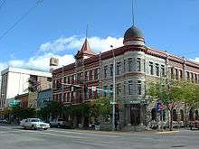
Missoula, often considered the cultural center of Montana,[61] is the location of the state's first university, and an eclectic mix of loggers, hippies, college students, sports fans, and retirees.[62] Community events generally take place downtown either outdoors or in one of the several downtown buildings listed on the National Historic Registry.[63]
Since 2006, the River City Roots Festival has been an event each August with music, beer, food, and art, and generally attracts crowds of 15,000.[64][65] The longest-standing event downtown has been the Missoula Farmers Market that was founded in 1972,[66] which provides an outlet for Western Montana produce on Saturday mornings from May to October as well as Tuesday evenings from July to early September.[67] An arts and crafts People's Market and a Clark Fork Market run concurrently.[68] Downtown hosts "First Friday Missoula", a gallery walk on the first Friday of the month to feature local art from museums and galleries,[69] such as that of Monte Dolack. Missoula celebrates "First Night Missoula" on New Year's Eve, which includes food and live entertainment.[70] The "Festival of the Book" to celebrate the literature of the American West was rebranded the "Montana Book Festival" in 2015.[71] Missoula's two historic theatres both hold annual film festivals: the Roxy hosting the International Wildlife Film Festival, established in 1977 as the first juried wildlife film festival in the world;[72] and since 2003, the Wilma accommodating the largest film event in Montana, the Big Sky Documentary Film Festival.[73]
In performance arts, the Missoula Community Theatre has held performances of musical and non-musical plays since 1977,[74] with its affiliated Missoula Children's Theatre also acting as an international touring program that visits nearly 1,000 communities per year around the world.[75] Missoula is also home to a number of modern dance companies, including Bare Bait Dance[76] and Headwaters Dance Company.[77] Rocky Mountain Ballet Theatre and Garden City Ballet are also based in Missoula.
The Montana Museum of Art & Culture, which became a state museum in 2001, is one Montana's oldest cultural reserves, having begun in 1894; its permanent collection of more than 10,000 original works.[78] The Missoula Museum of Art is housed in a former Carnegie library; it features contemporary art and annually features 20–25 group and solo exhibits.[79] Fort Missoula is home to the Historic Museum, dedicated to preserving the history of Western Montana, and to the Rocky Mountain Museum of Military History[80][81] and the Northern Rockies Heritage Center.[82] The National Museum of Forest Service History is constructing the National Conservation Legacy and Education Center in Missoula as well.[24]
.jpg)
Opened in 1987, Missoula's Bayern Brewing is the oldest active brewery in Montana.[83] Big Sky Brewing opened in 1995 and with a production of over 38,000 barrels in 2008, it is by far Montana's largest brewery, and produces the best-selling beer brewed in Montana, Moose Drool Brown Ale.[84][85] Missoula has also been home to Kettle House Brewing since 1995 and Draught Works opened in 2011. Big Sky, Bayern, and Kettlehouse represent the first, second, and third largest breweries respectively in the state of Montana.[86] Also in 2011, Tamarack Brewing and Flathead Lake Brewing Company from nearby Lake County opened pub houses at downtown Missoula locations. The city also holds annual the Garden City Brewfest and Winterfest, and also periodically hosts the Montana Brewers Festival.[87][88]
Missoula's celebration of the outdoors can also be seen in notable non-profits based in the city such as the Adventure Cycling Association, the conservationist-hunting organizations Boone and Crockett Club and Rocky Mountain Elk Foundation, and the Outdoor Writers Association of America.[89] In an attempt to reduce harmful emissions, the non-profit Missoula in Motion promotes environmentally sustainable transportation options for commuters, such as walking, biking, carpooling, public transportation, and telecommuting.[90] Other non-profits headquartered in Missoula illustrate the city's liberal reputation in Montana. Promoter of marijuana law reform NORML has its state headquarters in Missoula, as does the Montana Hemp Council. Forward Montana is a "left-leaning though officially nonpartisan group that seeks to engage young people in politics".[91] The Montana Justice Foundation, founded in 1979, is a charitable organization that helps underprivileged and underserved Montanans to access to civil legal aid. The Western Montana Community Center supports the LGBTIQ community[92][93] and the Jeannette Rankin Peace Center focuses on "nonviolence, social justice and environmental sustainability".[94] The largest emergency homeless shelter and soup kitchen in Montana, the Poverello Center, is also located in Missoula.
Sports
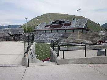
Missoula plays host to a variety of intercollegiate, youth, and amateur sports organizations in addition to a Minor league baseball team. The Montana Grizzlies' football and basketball teams of the University of Montana have the highest attendance. The Montana Grizzlies football team has a successful program within the NCAA D-1 FCS level. Their home games at Washington–Grizzly Stadium have a near 90% winning percentage and average over 25,000 spectators in attendance. All games are televised throughout Montana. The Grizzlies men's and Lady Griz basketball teams have also been successful at the conference level where they both rank at or near the top in attendance, about 4,000 and 3,000 respectively, and play their home games at Dahlberg Arena.[95][96][97]
Missoula is also home to the Missoula Osprey, a rookie affiliate of the Arizona Diamondbacks that plays in the Rocky Mountain-based Pioneer Baseball League. They play their home games at Ogren Park at Allegiance Field. Also competing regionally are the Hellgate Rollergirls, a roller derby team that competes at the Adam's Center.[98] Since 1977, Missoula has also held "Maggotfest", a festival-style rugby tournament hosted by the Missoula Maggots Rugby Club the first weekend in May. The non-elimination tournament focuses on the fun aspect of the game, attracting 36 teams (male and female) from around the United States and Canada. In regular season play, the Missoula Maggots compete as part of the Montana Rugby Union alongside another local rugby team, the University of Montana Jesters.[99]
Parks and recreation
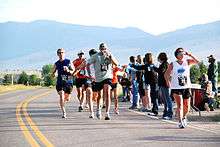
The city has over 400 acres (160 ha) of parkland, 22 miles (35 km) of trails, and nearly 5,000 acres (2,000 ha) of conserved open-space.[15] Located at the confluence of three rivers (the Clark Fork, Bitterroot, and Blackfoot), the area is also popular for white water rafting and, thanks largely to the novel and subsequent film A River Runs Through It by Missoula native Norman Maclean, is well known for its fly fishing. Additionally, Missoula has two aquatic parks,[15] multiple golf courses, is home to the Adventure Cycling Association, and hosts what Runner's World called the "best overall" marathon in the U.S.[100][101] There are also three ski areas within 100 miles (160 km): Montana Snowbowl, Discovery Ski Area, and Lost Trail Powder Mountain. Slightly farther away are Lookout Pass, Blacktail Mountain, and Big Mountain.[102]
A system of public parks was developed in Missoula in 1902 with the donation by lumber baron Thomas Greenough and his wife Tessie. They gave a 42-acre (17 ha) tract of land along Rattlesnake Creek for Greenough Park, on the condition that "the land forever be used as a park and for park purposes to which the people of Missoula may . . . find a comfortable, romantic and poetic retreat".[48]:110 In a follow-up nine years later in a letter to the Missoulian, he stressed his interest in having the park remain in as close to a native state as possible.[103] That request, along with the discovery that non-native Norway maples were inhibiting the growth of native trees and shrubs such as cottonwoods, ponderosa pines and Rocky Mountain maples, led to the controversial decision to remove Norway maples from the park with the hope of returning it to its natural state.[38][104]
In 1924, Bonner Park was created out of John L. Bonner's estate near the university. The park today has multiple athletic fields and courts in addition a band shell used by the Missoula City band through the summer.[105] The Kiwanis club set up a park downtown in 1934, making Kiwanis Park the first of a string of parks which line both sides of the Clark Fork River. One of those parks on the southern bank of the river is McCormick Park, which was created with WPA funds out of surplus highway land, a parcel from the American Hide and Fur Company, and land donated from the Kate McCormick estate. The 26-acre (11 ha) park, named for Washington J. McCormick and his wife is home to a skate park, aquatics center, a free bike check-out and a children's fishing pond.[106] Other popular parks include the Jacobs Island Bark Park, a designated area for dogs to play off-leash; the Montana State veterans' memorial rose garden;[107] Waterwise Garden, a "living laboratory" garden utilizing water conservation techniques; and Splash Montana Waterpark at Playfair Park.

Caras Park
Caras Park is located just south of the historic Wilma Theatre downtown. It is located on land reclaimed when the Higgins Avenue Bridge was widened from two lanes to four in 1962. Before the reclamation, the Clark Fork River divided to create an island with the north channel's bank extending to nearby buildings such as the Wilma Theatre. The south channel was deepened for the increased water flow and the infilled land later became Caras Park.[108] Events in the park were not common until the early 1980s and permanent fixtures like "Out to Lunch", which began in 1986. The Missoula Downtown Association took over from Parks and Recreation for management of the park and made improvements to make Caras Park more event-friendly. Seating, event circles, brick plazas, restrooms, and storage structures were added. Large temporary tents were used for events until 1997 when a permanent pavilion was constructed.[109] The park is a hub of city festivities including include "Out to Lunch", the International Wildlife Film Festival, First Night Missoula, Garden City BrewFest and offered intimate concert settings for artists such as Jewel, Chris Isaak, Santana, Ziggy Marley, and B.B. King.[110] Located next to Caras Park is A Carousel for Missoula, a wooden, hand-carved and volunteer-built carousel; and Dragon Hollow, a children's recreational area adjacent to the carousel.
Government and politics
| City Council[111][112] | |
|---|---|
| Mayor | John Engen |
| Ward 1 | Dave Strohmaier/Jason Wiener |
| Ward 2 | Adam Hertz/Cynthia Wolken |
| Ward 3 | Stacy Rye/Bob Jaffe |
| Ward 4 | Jon Wilkins/Caitlin Copple |
| Ward 5 | Dick Haines/Mike O'Herron |
| Ward 6 | Ed Childers/Marilyn Marler |
| Missoula's state delegation (Senate)[113] | |
| SD 46 | Sue Malek (D) |
| SD 47 | Dick Barrett (D) |
| SD 48 | Tom Facey (D) |
| SD 49 | David Wanzenried (D) |
| SD 50 | Cliff Larsen (D) |
| (House of Representatives)[114] | |
| HD 91 | Chuck Erickson (R) |
| HD 92 | Bryce Bennett (D) |
| HD 93 | Douglas Coffin (D) |
| HD 94 | Ellie Hill (D) |
| HD 95 | Tom Steenberg (D) |
| HD 96 | Carolyn Squires (D) |
| HD 97 | Nancy Wilson (D) |
| HD 98 | Jenifer Gursky (D) |
| HD 99 | Kimberly Dudik (D) |
| HD 100 | Champ Edmunds (R) |
Missoula's system of government has changed four times since 1883 when an aldermanic form of government was approved with the town charter. The city adopted a commission-council form of government in 1911 with the opening of new City Hall and a council–manager government in 1954 before returning to an aldermanic form of government in 1959. Since January 1, 1997, Missoula has been governed in accordance with the Missoula City Charter, which calls for a mayor-council system of government.
The current system comprises a mayor and city treasurer elected in a citywide vote and twelve city council members who must reside in and are elected from one of six wards with each ward having two council members. All positions are nominally nonpartisan. Council members and the mayor are elected to four-year terms with council-member elections being staggered to allow only one member from each ward to up for re-election. There are no term limits for either position.[115][116]
Missoula's state legislative delegation is the second largest in the Montana Legislature and is represented by districts 91–100 in the Montana House of Representatives and districts 46–50 in the Montana Senate.[117] Having thirteen Democrats and two Republicans in its state legislative delegation, Missoula is known as a more liberal area than the rest of the state.[113][114]
Though Missoula's political leanings may not be unique for a college town, its initiative to make marijuana possession the lowest priority of law enforcement in 2006,[118] and symbolic resolutions calling on Congress to withdraw from Iraq in 2007,[119] and to amend the U.S. Constitution to declare that "corporations are not human beings" in 2011,[120] often put it at odds with the rest of the state. In 2011, the Montana legislature, with a Republican House majority, attempted to overturn Missoula's marijuana law and revoke its ability to have an anti-discrimination ordinance that included the LGBT community. The marijuana repeal was vetoed by then–Governor Brian Schweitzer[121][122] and the attempt to repeal the other died in the Senate.[123]
Education
Hall.jpg)
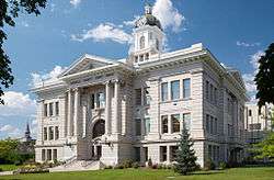
Missoula's first school was opened in late 1869 with sixteen students from around the region and their teacher Emma C. Slack who had come to Missoula via a two-month trip by horseback, railroad, and boat from Baltimore at the invitation of her brother. She resigned two years later upon marrying William H. H. Dickinson (the first couple married in Missoula) and was replaced by Elizabeth Countryman who later married Missoula's first mayor, Frank H. Woody.[124][125] The first public high school was opened in 1904 but was converted back to a grade school after the A. J. Gibson-designed Missoula County High School (now Hellgate High School) was opened in 1908.[126] After several expansions, Stanford University was commissioned in 1951 to create a master building plan to manage future growth. It suggested purchasing land and building an additional campus at the Garden City Airport's Hale Field, which was gradually being replaced by the Missoula County Airport, which was then southwest of town. The new school (now Sentinel High School) was opened in 1957. Initially the two campuses were separated between upper and lower classmen with upper classmen in the new school, but in 1965, the two campuses became separate high schools.[126] In 1974, the private Loyola Sacred Heart Catholic High School was created from a merger of the all-girls Sacred Heart Academy (est. 1873) and the all-boys Loyola High School (est. 1912).[127] In 1980, Missoula's third public high school, Big Sky, was established.[128]
Missoula's public schools are part of the Missoula County Public School districts 1, 4, 20, and 23.[129] In Missoula, there are nine public elementary schools (kindergarten to 5th grade), three public middle schools (6th to 8th grades), four public high schools (9th to 12th grades),[130] and three public schools serving kindergarten to 8th grade.[129] Missoula also has several private schools including an international school, religious-affiliated schools, as well as Next Step Prep, a theater academy high school operated by the Missoula Children's Theatre.[131]
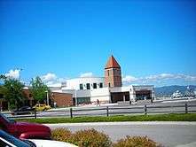
The University of Montana dominates higher education in Missoula.[52] The university, established in 1893, was Montana's first, and has the state's second-largest enrollment,[132] with 12,922 students as of 2015).[133] The campus houses six colleges and three schools including Montana's first and only law school, the Alexander Blewett III School of Law at the University of Montana. The university is also the location of the state's Regional Federal Depository Library,[134] and houses the state Arboretum.[135] The University of Montana College of Technology, established in 1956 and formerly known as the Missoula Vocational Technical Center, offers fast-track learning programs. Multiple vocational programs not affiliated with the university ranging from photography and massage to truck driving also have a presence in Missoula.[136]
Media
Broadcast
Missoula's single–broadcast over–air television media market is the largest in Montana and ranked 165 nationally in as of 2015.[137] Though Missoula itself is second in population to Billings, Montana, Missoula's single-broadcast over-air television media market includes all of Missoula, Ravalli, Granite, Mineral, Lake, Flathead, and Sanders Counties in the more densely populated western region of Montana and serves over 112,600 television homes as of 2015.[137][138] Missoula is home to three local affiliate channels: KPAX-TV (CBS/MTN, The CW; founded 1970; channel 8), KECI-TV (NBC; founded 1954 as KGVO-TV; channel 13, and KTMF-TV (ABC, FOX; founded 1991; channel 23). Also based in Missoula at the University of Montana is Montana PBS (founded 1984; channel 11). There are seventeen FM radio stations and four AM radio stations licensed in the city.
Missoula has four main sources of print media: the Missoulian (primary daily), Missoula Independent (alternative weekly), Montana Kaimin (college), and New West (digital, progressive). The Missoulian was founded as a weekly publication in 1870 as The Missoula and Cedar Creek Pioneer.[139] As of 2015, the Missoulian remains Missoula's most popular newspaper with a circulation of over 26,000,[140] making it the third most read daily newspaper in Montana behind the Billings Gazette and the Great Falls Tribune. The Missoula Independent (founded 1991) is the largest weekly newspaper in Montana and the states only member of the Association of Alternative Newsweeklies. With over 21,000 readers it has twice the circulation of second place Billings Outpost. The newspaper is distributed free to more than 600 locations across Western Montana from Hamilton in the south to Whitefish in the north.[141] The Montana Kaimin (founded 1891) is likewise distributed free throughout parts of Missoula with heavy student traffic from the University of Montana where the newspaper is printed Monday through Friday during the school year. New West was founded in 2005 as a left-leaning "next-generation media company" that focused on culture, environment, economy, and politics in the Rocky Mountain West.[142]
Infrastructure
Health care
Missoula has two primary health care facilities: St. Patrick Hospital and Health Sciences Center and Community Medical Center. St. Patrick's was founded in 1873 under the sponsorship of the Sisters of Providence. It is the only Level II trauma center in the region,[143] the largest medical facility in Western Montana, and has undergone three major expansions since the 1980s. The hospital has 195 acute-care beds, and admitted over 9,700 patients in 2003. The name was changed from "St. Patrick Hospital" to "St. Patrick Hospital and Health Sciences Center" in 2000 to reflect an increasing involvement with national medical research and education.[31] The Community Medical Center and its adjacent medical facilities are located near Fort Missoula and is part of a modern complex that includes a nursing home, the Missoula Crippled Children's Center, and private offices.[144] It was founded in 1922 as Thornton Hospital by doctors Will Thornton and Charles Thornton and has been at its current location since 1972. Although originally a locally owned, not-for profit hospital, it is now owned by a large corporation headquartered in Nashville, TN, and is a for-profit entity. It is the only hospital in Western Montana with a separate Pediatric Intensive Care Unit. The center is partnered with Seattle Children's Hospital.[144] The nearest Level I trauma center to Missoula is Harborview Medical Center in Seattle, Washington.
Utilities
The earliest Missoulians drew their water directly from the Clark Fork River or nearby Rattlesnake Creek. The first water system consisted of a Native American known as One-Eyed Riley and his friend filling buckets of water from the Rattlesnake Creek and hauling them door to door on a donkey cart.[145] In 1871 city co-founder Frank Worden began construction of a log pipe and wooden main system that flowed from the Rattlesnake Creek 2.5 miles (4 km) north of the city. With the addition of two small covered reservoirs, the first municipal water system was begun in 1880. With an intake dam built in 1901 with a settling basin capacity of 3 million US gallons (11,000 m3), the Rattlesnake Creek continued to meet demands of the city until 1935 when five wells were added to respond to increased summer and fall demand. This system is still maintained as an emergency backup, but was discontinued as a primary source after Giardia outbreak in 1983.[146] Since then, Missoula has relied on the Missoula Valley Aquifer as the sole source of water.[147] In 1889, the first electrical plant was built by A. B. Hammond to power his major downtown properties such as the Missoula Mercantile and the Florence Hotel. In 1905, the Missoula Mercantile (by then owned by Copper King William A. Clark purchased the water system and consolidated it with its vast electrical holdings to create the Missoula Light and Water Company (ML&W) a year later.[148] Electricity and water remained bundled after ML&W's sale to the Montana Power Company (MPC) in 1929. In 1979, MPC sold its water utility holdings as Mountain Water Company to Park Water Company in Downey, California, which since 2011 has been a subsidiary of The Carlyle Group.[149] In 2015, the City of Missoula was legally granted its "'right to acquire' the water system by exercising its power of eminent domain",[150] but as of June 2015, that decision is under appeal.[151]
Following the deregulation of Montana's electricity market in 1997, Montana Power Company began to divest its energy business. MPC sold substantially all its electrical generating assets to the PPL Corporation in December 1997 and its energy transmission and distribution business to NorthWestern Corporation in February 2002.[152] Despite filing for bankruptcy in 2002, NorthWestern Corporation's subsidiary NorthWestern Energy is the primary provider of electric and natural gas service to Missoula in addition to the Rural Utilities Service's Missoula Electric Cooperative.[153]
Local telephone service in the area is provided by CenturyLink and Blackfoot Telecommunications. Major cell phone providers include AT&T, Sprint, Verizon, and T-Mobile. Trash collection in Missoula is handled by Allied Waste Industries and Grant Creek Water Systems. Allied Waste also handles recycling through a program where customers can purchase special blue bags to designate recyclables. Recycling has also been offered by Missoula Valley Recycling since 1992, by Garden City Recycling since 2010 which offers curbside pickup, and by Pacific Steel & Recycling which offers drop-off recycling.[154] Sewer service is handled by the City of Missoula Wastewater Division.
City layout and development
In the mid-1860s, C. P. Higgins and Frank Worden began plotting what would become the town of Missoula along the Mullan Military Road, which ran parallel to the Clark Fork River. Through downtown Missoula, the route of the road is now Front Street.[124] It is intersected by Higgins Avenue, to which a bridge across the Clark Fork was added in 1873. The intersection of these two streets became the default center of the city, and remains the numerical center regarding city street addresses.[155] The arrival of the Northern Pacific Railway in 1883 led to a housing boom along the tracks, particularly on the northern side where many of the railway workers would reside. When the Higgins Avenue Bridge was replaced in 1893, they debated whether the bridge should continue southwest toward the Bitterroot Valley as it had earlier, or due south. Attorneys W. M. Bickford and W. J. Stephens had already laid out plots of land five years earlier for what they hoped would be a new town of "South Missoula". The streets there were perpendicular to the Bitterroot Wagon Road while Judge Hiram Knowles who owned the land just south of the river preferred the north-south plan and did not want to become part of South Missoula. The result was a 7×14–block area along the west side of Higgins Avenue commonly referred to as the Slant Streets centered along what is now Stephens Avenue. Stephens Avenue and Brooks Street are the only arterials to traverse the city diagonally along with the Bitterroot Branch of Montana Rail Link. The rest of the city, with the exception of Downtown, where streets follow the angle of the river, and newer expansions into the hills, strictly follow the grid plan.[124] With the establishment of the University of Montana in 1893 and the announcement that the now-defunct Milwaukee Road would be located south of the river, houses began to spread quickly throughout the university and south side districts. The area near the university was promoted as high-end and luxurious homes appeared on Hammond Avenue (then nicknamed "Millionaires Row" and known today as Gerald Avenue).[48]:32 The arrival of Interstate 90 in the mid-1960s forced the removal of 60 homes, including the Greenough Mansion. The north side of Missoula became isolated between the Interstate and the tracks while the Greenough Mansion was moved to a South Hills golf course and converted to a restaurant. This dichotomy has prevailed with the North Side feeling neglected by the city while the South Hills became an upscale neighborhood. With the release of the latest Missoula Downtown Master Plan in 2009, increased emphasis was directed toward redeveloping the North Side's former rail yard and the area just south of the tracks.[156][157]
The city is divided into 18 neighborhood councils of which all Missoula residents are a member.[158] The city further contains 10 historical districts: Downtown Missoula, East Pine Street, Fort Missoula, Lower Rattlesnake, McCormick, Northside, Southside, University Area and, the campus of the University of Montana.[159]
Trail system
Missoula has an extensive trail system for both commuting and recreation that extends over 22 miles (35 km). The city is actively trying to connect its various sections within the city to each other and to recreational trails extending beyond the city. The heart of the Missoula Commuter Bike Network are the trails along either side of the Clark Fork River that link Downtown with surrounding neighborhoods, the university, city parks, and outlying open space with smooth surfaces and three bicycle/pedestrian bridges. The most southern of these is Milwaukee Trail which follows the path of the former Milwaukee Railroad and continues east out of town as the Kim Williams Nature Trail beside Mount Sentinel. The Bitterroot Branch Trail connects to the Riverfront trails west of Downtown and, when completed, will provide a trail from Downtown to Southgate Mall. Near the Bitterroot Branch Trail, but not connected, is the South Avenue Trail on the west side of Reserve Street that connects the Community Medical Center with Fort Missoula, nearby athletic fields, and the Bitterroot River. The South Hills neighborhood has its own system of trails that is also approaching, but not quite meeting, the larger network.[160]
Transportation
Due to its rural location, highway access is especially important to Missoula. Interstate 90 runs east–west along the northern edge of Missoula at the base of the North Hills, with all but a small portion of the city located south of the highway. Completed in 1965 at the expense of 60 homes, the Garden City Brewery, and the Greenough Mansion, I‑90 has four city exits and makes connections with U.S. Route 93, U.S. Route 12, and Montana Highway 200.[156] The original U.S. 12, approved by the AASHO in 1939 to extend west into Montana did not include Missoula until the highway was rerouted along State Route 6 in October 1959 and was not extended west from Missoula until 1962. The road now crosses Missoula southwest–northeast.[161] U.S. 93 serves as a major economic corridor for western Montana connecting Missoula with the Bitterroot Valley communities to the south and Flathead Lake, Kalispell, and Glacier National Park to the north.[162] Montana Highway 200, the longest state highway in the United States enters Missoula from the east and provides access along the Blackfoot River and a direct route to Great Falls.
Public transportation in Missoula began as early as 1890 with a horse-drawn streetcar system (electrified in 1910) operated by the Missoula Street Railway Company that connected Downtown Missoula with the University, Bonner, the fairgrounds, and Fort Missoula. These streetcars were then replaced by buses in 1932 due to cost.[163][164] Bus service today is provided by Mountain Line, a public transit agency created by public vote in 1976 as part of the Missoula Urban Transportation District (MUTD) that began operation in December 1977. Mountain Line operates twelve bus routes within a 36-square-mile (93 km2) area, serving Missoula, East Missoula, Bonner, Target Range, Rattlesnake, and the airport. Additionally the line has offered paratransit services since 1991 to assist the disabled, senior van since 2008, and has four park‑and‑ride lots throughout Missoula.[165] Special bus service is offered to the University of Montana through three of the city's park‑and‑ride lots in addition to a late-night UDASH shuttle that offers service between the University and Downtown.[166] As of January 2015 a three-year pilot program of zero fare transportation on all Mountain Line busses began, with the goal of increasing use by 45 percent.[167]
Direct intercity ground travel needs are provided by bus carriers Greyhound Lines and Rimrock Trailways. Intercity rail travel was available from 1883, when the Northern Pacific Railway began service through Missoula, until 1979 when Amtrak discontinued its North Coast Hiawatha route across southern Montana. In 1901, Northern Pacific built their station at the terminus of Higgins Avenue; since 1985, it has been on the National Register of Historic Places.[168] A feasibility study was commissioned by Congress in 2008 to examine the merits of reopening the North Coast Hiawatha, but as of 2008, the nearest rail station to Missoula is the Whitefish station of Amtrak's Empire Builder, 136 miles (219 km) to the north.[169]
Air
Air travel to Missoula began in 1927, which is served by Missoula International Airport at Johnson-Bell Field, a public airport run by the Missoula County Airport Authority. It is the largest airport in western Montana, serving 582,821 passengers in 2011.[170][171] The current building contains three jet bridges and three ground‑level boarding gates. There are direct flights year‑round to Billings,[172] Denver, Las Vegas, Minneapolis, Phoenix, Portland, Salt Lake City, Seattle, and seasonally to Atlanta, Chicago, Los Angeles, Oakland, and San Francisco.[174] Four airlines operate out of Missoula (Allegiant Air, Delta Air Lines, Horizon/Alaska Airlines, and United Airlines) in addition to cargo carriers FedEx Express, and UPS Airlines.[175] The airport is also home to Homestead Helicopters and fixed‑base operators Minuteman Jet Center (an Avfuel fuel provider), and Northstar Jet (a Phillips 66 fuel provider).
Notable people
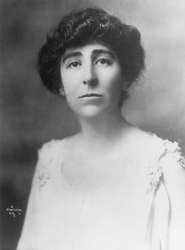
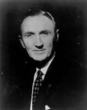
Missoula has produced and been home to a number of notable individuals in varying fields. Its natives and residents are referred to as "Missoulians". In politics, Jeannette Rankin,[16] the first woman in congress, was born and raised in Missoula while Senators Mike Mansfield,[17] the U.S.'s longest serving Senate Majority Leader, and Max Baucus,[176] Montana's longest serving U.S. Senator both established careers and joined politics while living in the city. Noted athletes who were born or resided in Missoula include five Olympic medalists, Pro Football Hall of Fame Quarterback John Elway,[177] and former Milwaukee Bucks coach Larry Krystowiak.[178] Actor Dana Carvey,[179] filmmaker David Lynch,[180] and award‑winning biologist Leroy Hood[181] were born in Missoula while Carroll O'Connor[182] and J. K. Simmons[183] both attended the University of Montana. Composer David Maslanka,[184] musician Jeff Ament,[185] and musician and vlogger Hank Green[186] reside in Missoula. Academically, Missoula has been home to Nobel Prize winners Harold C. Urey[187] and Steve Running[188] as well as 20th century Montana historian K. Ross Toole[189] Noted names in literature include Native-American poet James Welch,[190] crime novelist James Crumley,[191] former head of the University of Montana's Creative Writing Program Richard Hugo,[192] and Norman Maclean,[193] whose A River Runs Through It chronicles his life in early 20th-century Missoula.
Sister cities
Missoula has two[194] sister cities, as designated by Sister Cities International:
-
 Neckargemünd, Germany
 -
 Palmerston North, New Zealand
Missoula's Sister City relationship with Palmerston North, New Zealand, began after Missoula resident and later University of Montana professor Harold Bockemuehl returned from obtaining his PhD from Massey University. The relationship was made official in 1983 after a meeting between then UM President Neil Bucklew and officials from Massey University. Each May, Missoula celebrates "New Zealand Day" in honor of the relationship with rugby, food, and entertainment.[195] Missoula's second Sister City relationship began in 1991 after a Neckargemünd delegation, led by Mayor Oskar Schuster, visited Missoula following a Fulbright-sponsored faculty exchange between Heidelberg University and the University of Montana. Every September the Missoula Cultural Council holds an annual "Germanfest" to celebrate German culture and this relationship.[194][196]
Portrayal in media
| “ | . . . the world outside, which my brother and I soon discovered was full of bastards, the number increasing rapidly the farther one gets from Missoula, Montana. | ” | |
| — Norman Maclean, A River Runs Through It [197] | |||
Author Norman Maclean grew up in Missoula and wrote about it in his 1976 autobiographical novella A River Runs Through It.[198] The work was adapted into a 1992 motion picture of the same name, directed by Robert Redford, starring Brad Pitt and Craig Sheffer.
Missoula: Rape and the Justice System in a College Town is the title of a 2015 book by Jon Krakauer that looked at the Justice Department's investigation into a "pattern of disrespect and indifference toward alleged victims" by Missoula law enforcement in sexual assault cases between 2010 and 2012, some involving football players from the Montana Grizzlies.[199][200] While being interviewed on NPR about the book, John Krakauer stated "I don't mean to single out Missoula: Its rape rate is a little less than the national average; I think its problems with dealing with rape are pretty depressingly typical".[201]
There is a lengthy study of Missoula in the title essay of Jonathan Raban's Driving Home: An American Journey: despite writing that on his arrival, "I had the powerful impression that I had driven deep into the Rocky Mountains and somehow arrived in Rotherham or Barnsley,"[202] and that "the overall effect [of the city] was oddly unsettling; the streets too open for comfort, the town too closed in, inducing mild claustrophobia and agoraphobia at the same time",[202] he notes the literary heritage of the city and its reputation as a "kindly town" (evidenced by its being a place where "odds and ends naturally collected and cohered").
Missoula was portrayed in an episode of the CBS show Criminal Minds. The episode aired on November 5, 2014.
Missoula (as well as Jermone, MT) was also portrayed in the movie Chill Factor released in 1999 starring Skeet Ulrich and Cuba Gooding, Jr.
References
- 1 2 "About Missoula". Destination Missoula. Archived from the original on 2015-06-11. Retrieved 2015-08-26.
- 1 2 "Gazetteer Files: Montana Places". United States Census Bureau. 2015.
- ↑ "Gazetteer Files: Urban Areas" (ZIP). United States Census Bureau. 2015.
- ↑ "Gazetteer Files: Core Based Statistical Areas" (ZIP). United States Census Bureau. 2015. Archived from the original on 2015-08-28.
- 1 2 "American FactFinder: Profile of General Population and Housing Characteristics". United States Census Bureau. Retrieved 2015-08-25.
- 1 2 "Population Estimates". United States Census Bureau. Retrieved June 15, 2016.
- 1 2 "Look Up a ZIP Code". USPS. Archived from the original on 2015-08-09.
- 1 2 Gilder, Don. "Three, Five or Eight: Judge Woody Would Hold His Nose". Old Missoula. Archived from the original on 2015-08-15. Retrieved 2015-08-15.
- ↑ "Archived copy". Archived from the original on 2016-04-17. Retrieved 2015-08-08.
- ↑ "American FactFinder: 2015 Population Estimates". United States Census Bureau. 2015-07-01. Retrieved 2016-05-16.
- 1 2 "U.S. Census Bureau Delivers Montana's 2010 Census Population Totals, Including First Look at Race and Hispanic Origin Data for Legislative Redistricting". Census 2010 News. United States Census Bureau. Retrieved 2015-08-23.
- 1 2 3 "Early, Early Missoula". Historic Missoula. Missoula's Office of Planning and Grants. Archived from the original on 2015-02-14. Retrieved 2015-08-08.
- 1 2 "Arrival of the Railroad (1883–1893)". Historic Missoula. Missoula's Office of Planning and Grants. Archived from the original on 2015-02-14. Retrieved 2015-08-08.
- 1 2 "Top employers in the city of Missoula". Missoulian. Missoula. 2009-12-15. ISSN 0746-4495. Archived from the original on 2015-08-28. Retrieved 2015-08-14.
- 1 2 3 "Missoula Official Website: Parks & Recreation". City of Missoula. Retrieved 2015-08-09.
- 1 2 "Cool Montana Stories: Jeannette Rankin". Travel Montana. 2007. Archived from the original on 2015-07-01. Retrieved 2015-08-13.
- 1 2 Oberdorfer, Don (2015) [1st pub. 2003]. Senator Mansfield: The Extraordinary Life of a Great American Statesman and Diplomat. Washington, D.C.: Smithsonian Institution. p. 61. ASIN B00RKQ648Y. ISBN 978-1-58834-514-1. LCCN 2003045553. OCLC 903929842. OL 8965072W.
- ↑ "Cities and Towns § Missoula". Montana: A State Guide Book. Works Progress Administration: American Guide. Compiled by the Federal Writers' Project (4th ed.). New York: Hastings House Publishers. 1955 [1st pub. 1939]. p. 173. ISBN 978-0-403-02176-5. OCLC 869757480.
The Salish had to pass through Hell Gate Canyon to reach the plains on their periodic buffalo hunts. At the entrance to the canyon, an ideal spot for an ambush, the Blackfeet would attack them. The reputation of the place caused French-Canadian trappers to call it ‘Porte de l’Enfer’ or ‘Gate of Hell’.
- ↑ "Travelers Rest". Montana Fish, Wildlife & Parks. Montana State Parks. Archived from the original on 2015-09-05. Retrieved 2015-10-05.
- ↑ "Meriwether Lewis". TwoRiversHistory.net. Retrieved 2012-02-08.
- ↑ "Hell Gate Village Era (1860–1865)". Historic Missoula. Missoula's Office of Planning and Grants. Archived from the original on 2015-02-03. Retrieved 2015-08-08.
- ↑ "Livability" (PDF). City of Missoula. Archived from the original on 2015-08-23. Retrieved 2015-08-23.
Missoula's name is derived from "nmesuletkw", the Salish word for the Clark Fork River, which translates to, "place of frozen water".
- ↑ "Missoula History". Destination Missoula. Archived from the original on 2015-08-12. Retrieved 2015-08-24.
- 1 2 3 "About Us: Frequently Asked Questions". National Museum of Forest Service History. Archived from the original on 2014-10-22. Retrieved 2015-08-26.
- ↑ "Our Organization". United States Forest Service. United States Department of Agriculture. Archived from the original on 2015-06-16. Retrieved 2015-08-26.
- ↑ Briggeman, Kim (2008-02-29). "Missoula anti-pollution group celebrates its victories". Independent Record. Helena. Archived from the original on 2015-08-28. Retrieved 2015-08-28.
- ↑ Hall, Richard (1969-02-07). "Air Pollution". Life. Vol. 66 no. 5. New York: Time. pp. 42–43. ISSN 0024-3019.
As they drive to work through it—sometimes with their car lights turned on in broad daylight—Missoulians complain a lot.
- ↑ "In the beginning of the MAEDC". Missoulian. Missoula. 2010-08-14. ISSN 0746-4495. Archived from the original on 2015-08-28. Retrieved 2012-01-28.
- ↑ Polzin, Paul E. (Spring 1994). "Montana's Economy: State of the Economy". Montana Business Quarterly. UM Bureau of Business and Economic Research. 32 (1): 6–15. Retrieved 2015-08-27 – via ProQuest. (subscription required (help)).
- ↑ "Missoula Carbon Monoxide SIP Case History". Citizen's Guide to Air Quality in Montana. Montana Department of Environmental Quality. Archived from the original on 2016-01-22.
- 1 2 "St. Patrick Hospital, Missoula, Montana". Retrieved 2015-08-08.
- ↑ "George M. Dennison". University of Montana. Retrieved 2012-04-22.
- ↑ Cohen, Betsy (2009-12-18). "Slow economic growth forecast for 2010; Missoula will soon be largest city in Montana". Missoulian. Missoula. ISSN 0746-4495. Archived from the original on 2015-08-28. Retrieved 2012-01-28.
- ↑ "Section D: Background". Ice Age Floods: Study of Alternatives and Environmental Assessment. Seattle: National Park Service. 2001. Archived from the original on 2015-06-11. Retrieved 2015-08-24.
- ↑ "Glacial Lake Missoula". United States Geological Survey. Archived from the original on 2015-08-09. Retrieved 2015-08-09.
- 1 2 "Missoula Conservation Lands Management Plan" (PDF). Missoula Parks and Recreation. 2010-06-01. Archived from the original on 2012-07-23. Retrieved 2015-08-24.
- ↑ Rice, Peter M. "Blackfoot Drainage New Weeds Risk Assessment". Invaders Database System. Missoula: University of Montana. Archived from the original on 2014-12-21. Retrieved 2015-10-02.
- 1 2 Chaney, Rob (2011-09-28). "City sees some success removing Norway maples from Greenough Park". Missoulian. Missoula. ISSN 0746-4495. Archived from the original on 2015-08-28. Retrieved 2015-08-09.
- ↑ "Station Information Data Sheet: Missoula, Montana". NOAA. January 1998. Retrieved 2012-01-28.
- ↑ "Climatography of the United States No. 20 1971–2000" (PDF). NOAA. February 2004. Archived from the original (PDF) on 2015-02-12. Retrieved 2015-08-08.
- ↑ "NowData: NOAA Online Weather Data". National Oceanic and Atmospheric Administration. Retrieved 2015-09-10.
- ↑ "Temperature-Related Normals: Missoula, Montana International Airport". National Oceanic and Atmospheric Administration. Retrieved 2015-09-10.
- ↑ "WMO Climate Normals for Missoula/Johnson–Bell Field, MT 1961–1990". National Oceanic and Atmospheric Administration. Retrieved 2015-09-10.
- ↑ "Annual Estimates of the Resident Population for Incorporated Places: April 1, 2010 to July 1, 2015". Retrieved July 2, 2016.
- ↑ Moffatt, Riley (1996). "Montana". Population History of Western U.S. Cities and Towns, 1850–1990. Lanham, Maryland: Scarecrow Press. p. 133. ISBN 0-8108-3033-7. LCCN 95-14583. OCLC 32274538. OL 2912313W.
- 1 2 3 "Educational Attainment: 2010–2014 American Community Survey 5‑Year Estimates". American FactFinder. United States Census Bureau. 2014. Retrieved 2016-03-04.
- 1 2 "Cities and Towns § Missoula". Montana: A State Guide Book. Works Progress Administration: American Guide. Compiled by the Federal Writers' Project (4th ed.). New York: Hastings House Publishers. 1955 [1st pub. 1939]. p. 174. ISBN 978-0-403-02176-5. OCLC 869757480.
- 1 2 3 4 Mathews, Allan James (2002). A Guide to Historic Missoula. Montana Mainstreets. 6. Montana Historical Society. ISBN 978-0-917298-89-9. LCCN 2002015675. OCLC 50738243. OL 8339475M.
- ↑ Kuehn, Scott. "History of Logging and Lumber Mills in Missoula". Society of American Foresters. Archived from the original on 2015-08-24. Retrieved 2015-08-24.
- ↑ "2011 Economic Outlook Seminar: Missoula County" (PDF). Bureau of Business and Economic Research. 2011. Archived from the original (PDF) on 2015-06-03. Retrieved 2015-08-24.
- 1 2 "Missoula FY2012 Adopted Budget: Statistical Section". City of Missoula. 2011-11-14. Retrieved 2012-02-01.
- 1 2 Seninger, Stephen F. (Winter 1997). "Town and Gown: The Economic Partnership between the University of Montana and Missoula". Montana Business Quarterly. UM Bureau of Business and Economic Research. 35 (4): 16–21. ISSN 0026-9921. Retrieved 2015-08-24 – via ProQuest. (subscription required (help)).
- ↑ Fanguy, Joe. "Office of Technology Transfer". University of Montana. Retrieved 2015-08-08.
- ↑ "Economoic Area Geographic Structure" (XLS). Bureau of Economic Analysis. 2012-01-20. Archived from the original on 2013-03-02. Retrieved 2015-08-24.
- ↑ "BEA Economic Areas". Bureau of Economic Analysis. Archived from the original on 2013-03-20. Retrieved 2015-08-24.
- ↑ "Missoula Greater Downtown Master Plan: Employment Analysis and Recommendations" (PDF). The Hingston Roach Group. 2008-12-10. Archived (PDF) from the original on 2015-02-03. Retrieved 2015-08-15.
- ↑ Cohen, Betsy (2010-12-19). "Missoula economy stands on many legs". Billings Gazette. ISSN 2372-868X. Archived from the original on 2015-08-28. Retrieved 2015-08-08.
- ↑ U.S. Metro Economies (PDF) (Report). United States Conference of Mayors. 2013. p. 7. Archived (PDF) from the original on 2015-05-01. Retrieved 2015-08-24.
- 1 2 "Bearfacts Personal Income" (PDF). Bureau of Economic Analysis. 2014-11-20. Archived from the original on 2015-08-24.
In 2013, Missoula had a total personal income . . . of $4,181,210 . . . This TPI ranked 333rd in the United States. In 2003, the TPI of Missoula was $2,831,543 . . . and ranked 334th in the United States.
- ↑ "Missoula, Montana Metropolitan Unemployment Rate and Total Unemployed". Department of Numbers. Archived from the original on 2015-08-12.
- ↑ "Profile: University of Montana". Fort Wayne, Indiana: National Student Exchange. 2015. Archived from the original on 2016-01-02.
Missoula is . . . often referred to as the cultural center of Montana. Students take advantage of . . . theatre, art walks, festivals, and concerts.
- ↑ "Community". Make it Missoula. Archived from the original on 2015-03-16. Retrieved 2015-08-24.
It's not everywhere that you'll find loggers and ranchers co-existing with holdover hippies and artistic types. Add in college students, immigrants, young families, retirees, entrepreneurs, minimalists, sports fanatics, green living addicts, and everything in between, and you have a rich, vibrant, and diverse community.
- ↑ "Historic Missoula Downtown Walking Tour". Missoula Downtown Association. Retrieved 2012-02-08.
- ↑ Leggett, Bob (2014-08-27). "River City Roots Festival conquers rainy weather in Missoula". AXS. Archived from the original on 2015-08-15.
. . . crowds for the event normally run about 15,000 . . .
- ↑ "River City Roots Festival". Retrieved 2015-08-15.
- ↑ "Missoula's Farmer's Market". Retrieved 2015-08-23.
The Missoula Farmers Market, a gathering of food and friends since 1972.
- ↑ "Farmers Markets in Missoula". Destination Missoula. Archived from the original on 2015-04-26. Retrieved 2015-08-24.
8:30 a.m. – 12:30 p.m. Saturdays, mid-May to mid-October; 5:30 p.m. – 7:00 p.m. Tuesdays, July – early September
- ↑ Lewis, Leah. "Farmer's Markets, Missoula Style". Make it Missoula. Retrieved 2012-02-08.
- ↑ "First Friday Missoula". Missoula Cultural Council. Archived from the original on 2015-04-20. Retrieved 2012-02-08.
- ↑ "First Night Missoula". Missoula Cultural Council. Archived from the original on 2015-03-19. Retrieved 2015-08-23.
- ↑ "Festival of the Book". Missoula: Humanities Montana. 2015. Archived from the original on 2015-08-24.
In 2015, The Humanities Montana Festival of the Book has been reestablished as the Montana Book Festival under the auspices of the Montana Book Festival Association, in conjunction with the Missoula Cultural Council.
- ↑ "'International Wildlife Film Festival' Showcase". Montana PBS. 2014. Archived from the original on 2015-06-04. Retrieved 2015-08-24.
The International Wildlife Film Festival . . . was founded as the world's first juried wildlife film competition in 1977.
- ↑ "About BSDFF". Big Sky Documentary Film Festival. Archived from the original on 2015-07-27. Retrieved 2015-08-14.
The Big Sky Documentary Film Festival has become the largest cinema event in Montana and the premiere venue for non-fiction film in the American West. In 2012, the festival drew an audience of 20,000 and received nearly 1000 film entries from every corner of the globe.
- ↑ "MCT: The Full Story". Missoula Community Theatre, Inc. Retrieved 6 September 2016.
- ↑ "MCT Tour in Your Town". Missoula Children's Theatre. MCT, Inc. Retrieved 6 September 2016.
- ↑ "Bare Bait Dance". Bare Bait Dance. Retrieved 6 September 2016.
- ↑ "Headwaters Dance Co.". Headwaters Dance Co. Retrieved 6 September 2016.
- ↑ "Mission & History". Montana Museum of Art & Culture. Retrieved 2015-08-24.
- ↑ "Vibrant and Colorful: For the Art Lover" (PDF). Destination Missoula: Missoula Area Visitor Guide. 2015. p. 17. Archived (PDF) from the original on 2015-08-10.
. . . Missoula Art Museum, which features contemporary works by Native American and regional artists as well as traveling exhibits. The space alone is worth the trip. A recent renovation marries the 100-year-old Carnegie Library building with a contemporary addition, creating a bright and airy space with lots of interesting angles and viewpoints. The museum does an amazing job keeping things fresh – 20 to 25 solo and group exhibitions rotate through six state-of-the-art galleries each year.
- ↑ "Rocky Mountain Museum of Military History". Retrieved 2015-08-24.
- ↑ "Historical Museum Tour Map" (PDF). The Historical Museum of Fort Missoula. Retrieved 2015-08-24.
- ↑ "Northern Rockies Heritage Center". Retrieved 2015-08-24.
- ↑ "Bayern Brewing: About". Archived from the original on 2015-08-10. Retrieved 2015-08-23.
Proud to be the only German brewery in the Rocky Mountains . . .
- ↑ Schneider, Bill (2008-05-28). "Big Sky Brewing: Moose Drooling with Success". New West. Archived from the original on 2008-09-07. Retrieved 2015-08-09.
- ↑ "Big Sky Brewing Company". Retrieved 2012-02-08.
- ↑ "Brew Town". Missoula Magazine. p. 51. Archived from the original on 2015-08-23. Retrieved 2015-08-23.
The three largest breweries – Bayern Brewing Inc., Big Sky Brewing Co. and KettleHouse Brewing Co. – call Missoula home.
- ↑ "Garden City Brew Fest 2010". Issuu. 2010-04-29. Retrieved 2011-11-17.
- ↑ "4th Annual Montana Brewers Festival". Montana Brewers Association. Archived from the original on 2014-02-28. Retrieved 2015-08-09.
- ↑ "Missoula Montana Non Profit Organizations". NonProfitList.org. Retrieved 2012-02-08.
- ↑ "Non-Profit Missoula in Motion". Retrieved 2012-09-11.
- ↑ Stolberg, Sheryl Gay (2013-02-10). "In Montana, Young, Liberal and Open to Big Government". The New York Times. p. A1. ISSN 0362-4331.
'Young people absolutely believe that there's a role for government', said Matt Singer, a founder of Forward Montana, a left-leaning though officially nonpartisan group that seeks to engage young people in politics.
- ↑ Szpaller, Keila (2011-03-01). "Missoula LGBTIQ nonprofit forms women's group, expands fundraiser". Missoulian. Missoula. ISSN 0746-4495. Archived from the original on 2015-08-28.
. . . the Western Montana Community Center . . . has been 'serving the LGBTIQ community since 1998', and this year, it has a women's group.
- ↑ "The Western Montana Community Center". Retrieved 2012-02-08.
- ↑ Inbody, Kristen (2015-05-31). "Montana Moment: Pacifist suffragette Rankin becomes first Congresswoman". Great Falls Tribune. ISSN 2329-647X. Archived from the original on 2015-10-02. Retrieved 2015-10-02.
The Jeannette Rankin Peace Center aims to continue . . . Rankin's legacy, with a mission of 'Working together for nonviolence, social justice and environmental sustainability'
- ↑ "NCAA Football Attendance Records" (PDF). NCAA. 2011. Retrieved 2012-01-28.
- ↑ "2011 NCAA Women's Basketball Attendance" (PDF). NCAA. Archived from the original (PDF) on 2013-05-18. Retrieved 2015-08-09.
- ↑ "2011 NCAA Men's Basketball Attendance" (PDF). NCAA. Archived from the original (PDF) on 2013-05-18. Retrieved 2015-08-09.
- ↑ "Hellgate Rollergirls". Retrieved 2015-08-09.
- ↑ "Missoula All-Maggots Rugby Club". Retrieved 2012-02-08.
- ↑ Hamilton, Michelle (January 2010). "Marathon Guide 2010". Runner's World. Retrieved 2015-08-09.
Best Overall: Missoula Marathon
- ↑ "Welcome to Run Wild Missoula". Retrieved 2012-02-08.
- ↑ "Missoula Montana: Ski Resorts". AllTrips. Retrieved 2012-02-08.
- ↑ "Greenough Park". Montanan Online. Fall 2002. Archived from the original on 2015-08-09. Retrieved 2015-08-09.
- ↑ Cramer, John (2007-10-17). "Botanist removes invasive tree species to restore Greenough Park". Missoulian. Missoula. ISSN 0746-4495. Archived from the original on 2015-08-28. Retrieved 2015-08-09.
- ↑ "Missoula City Band presents Summer Band Concerts 2011". Missoula City Band. Retrieved 2012-02-08.
- ↑ Chaney, Rob (2006-10-28). "Missoulians swim down memory lane". Missoulian. Missoula. ISSN 0746-4495. Archived from the original on 2015-08-28. Retrieved 2012-01-28.
- ↑ "State Veterans' Memorial Rose Garden (MCA § 1-1-518)". Montana Code Annotated. Montana Legislative Services. 1999. Archived from the original on 2015-01-03. Retrieved 2015-08-25.
The Missoula memorial rose garden, located in Missoula, Montana, is officially designated as a state veterans' memorial rose garden.
- ↑ "Bridge Plan Is Favored at Missoula". The Spokesman-Review. Spokane, Washington. 1960-02-06. ISSN 1064-7317.
- ↑ "Caras Park: Missoula's Town Square & Management: An Historical Perspective on Development" (PDF). Retrieved 2015-08-25.
- ↑ "Caras Park". Retrieved 2015-08-09.
- ↑ "Missoula City Council Members". City of Missoula. Retrieved 2015-08-09.
- ↑ Szpaller, Keila (2011-11-10). "Newcomers will make Missoula City Council younger, more diverse". Missoulian. Missoula. ISSN 0746-4495. Archived from the original on 2015-08-28. Retrieved 2015-08-09.
- 1 2 "Montana Senate Roster 2011 Regular Session". Montana Legislature. Retrieved 2012-02-08.
- 1 2 "Montana House Roster 2011 Regular Session". Montana Legislature. Retrieved 2012-02-08.
- ↑ "Missoula Historical Notes: Spotlights". City of Missoula. Retrieved 2015-08-09.
- ↑ "City of Missoula Charter" (PDF). City of Missoula. Archived from the original on 2014-10-03. Retrieved 2015-08-25.
- ↑ "Map of Montana Legislature Districts" (PDF). Montana State Library. Montana Geographic Information Clearinghouse. Archived (PDF) from the original on 2015-03-18. Retrieved 2015-08-09.
- ↑ "Missoula County Initiative No. MCSO2006-02 Community Oversight Committee". County of Missoula. Archived from the original on 2015-08-25. Retrieved 2015-08-25.
- ↑ Moore, Michael (2007-11-07). "Missoula approves withdrawal referendum". Independent Record. Helena. Archived from the original on 2015-08-28. Retrieved 2015-08-28.
- ↑ Szpaller, Keila (2011-11-09). "Missoula voters say corporations are not people, ask for constitutional amendment". Billings Gazette. ISSN 2372-868X. Archived from the original on 2015-08-28. Retrieved 2015-08-28.
- ↑ Johnson, Charles S. (2011-04-14). "Governor vetoes repeal of medical marijuana law". Missoulian. Missoula. ISSN 0746-4495. Archived from the original on 2015-08-28.
- ↑ Florio, Gwen (2011-10-01). "Minor pot crimes to be enforced again, Missoula County attorney says". Missoulian. Missoula. ISSN 0746-4495. Archived from the original on 2015-08-28. Retrieved 2012-02-08.
- ↑ Johnson, Charles S. (2011-02-22). "House Bill Would Overturn Missoula's Anti-Discrimination Ordinance for Gays, Lesbians". Billings Gazette. ISSN 2372-868X. Archived from the original on 2015-08-28. Retrieved 2012-02-08.
- 1 2 3 "Missoula History Minutes". The Historical Museum at Fort Missoula. Archived from the original on 2015-02-01. Retrieved 2015-08-23.
- ↑ "Guide to the William H. H. and Emma Dickinson Papers 1823–1908". Archives West. Orbis Cascade Alliance. Archived from the original on 2015-08-09. Retrieved 2015-08-09.
- 1 2 Briggeman, Kim (2008-09-28). "Hallowed halls: Missoula high school celebrates 100 years and two names". Missoulian. Missoula. ISSN 0746-4495. Archived from the original on 2015-08-28. Retrieved 2015-08-25.
- ↑ "Loyola Sacred Heart: Student–Parent Handbook" (PDF). Loyola Sacred Heart Catholic High School. 2011. p. 6. Archived (PDF) from the original on 2015-08-25.
- ↑ Cohen, Stan (2008). "Buildings, Schools, Churches, Hospitals, and Homes". Missoula. Postcard History Series. Charleston, South Carolina: Arcadia Publishing. p. 31. ISBN 978-0-7385-5888-2. LCCN 2008928325. OCLC 232130700.
Missoula's third public high school, Big Sky, was opened in 1980.
- 1 2 "Missoula County Administrators". County of Missoula. September 2014. Archived from the original on 2015-08-10. Retrieved 2015-08-10.
- ↑ "School District 1 High Schools: High School Attendance Boundaries in the Missoula Urban Area" (PDF). Missoula County Public Schools. Archived (PDF) from the original on 2015-04-20.
- ↑ "Missoula County Public Schools". Missoulian. Missoula. 2014-03-24. ISSN 0746-4495. Archived from the original on 2015-08-28.
Next Step Prep is a high-quality, accredited training program run by the Missoula Children's Theatre for students who are considering the performing arts as a major in college or as a career. The school is designed to provide students with the skills they will need for postsecondary studies in the performing arts including acting, singing and dancing. Students entering grades 9–12 may apply for this six-week summer session.
- ↑ "College Navigator: Montana" (XLS). National Center for Education Statistics.
- ↑ "UM Releases Spring Enrollment Numbers". University of Montana. 2015-03-03.
- ↑ "Partnership Showcase: Mansfield Library at the University of Montana". Federal Depository Library Program. 2013-03-07. Archived from the original on 2015-08-09.
The Mansfield Library became a Federal depository library in 1909 and the regional depository for Montana in 1965.
- ↑ "State Arboretum (MCA § 1-1-513)". Montana Code Annotated. Montana Legislative Services. 1995. Archived from the original on 2015-01-03. Retrieved 2015-08-23.
The campus of the university of Montana-Missoula, is the state arboretum.
- ↑ "Make it Missoula: Specialty Schools". Make it Missoula. Retrieved 2012-02-08.
- 1 2 "Local Television Market Universe Estimates" (PDF). Nielsen. p. 4. Archived (PDF) from the original on 2015-07-12. Retrieved 2015-08-09.
- ↑ "Montana television market map". Dish User. Archived from the original (GIF) on 2015-10-16. Retrieved 2012-04-28.
- ↑ Wilhelm, Honor L. (December 1906). "Missoula, Montana". The Coast. Seattle: The Coast Publishing Company. 12 (6): 279.
- ↑ "Highest Circulation Montana Newspapers". MondoTimes. Retrieved 2015-08-09.
- ↑ "About Us". Missoula Independent. Retrieved 2011-11-17.
- ↑ "New West". August Publications. Retrieved 2015-08-23.
- ↑ "Trauma Centers: Montana". American College of Surgeons. Chicago.
- 1 2 Wirth, Rudolph E. "History". Community Medical Center. Archived from the original on 2015-08-26.
- ↑ Chaney, Rob (2011-01-02). "Missoula has never controlled its own water destiny". Missoulian. Missoula. ISSN 0746-4495. Archived from the original on 2015-08-28. Retrieved 2015-08-13.
Back in 1870, Missoulians got their water from One-Eyed Riley and his Missoula Water Works. Riley's original system was a yoke and two buckets that he hauled door to door.
- ↑ "Mountain Water Company's Roots". Mountain Water Company. Archived from the original on 2007-08-22. Retrieved 2015-08-13.
In 1871, the first actual system was begun with log pipes and wooden mains . . . The Rattlesnake Intake Dam was built in 1901 with a settling basin capacity of 3 million gallons . . . Missoula's water needs were met by the Rattlesnake Creek until 1935, when five wells were added to augment fall and summer demands. In fact, the watershed was used until 1983, when a Giardia problem arose and its use was discontinued.
- ↑ "The Missoula Aquifer". Mountain Water Company. 2014-03-26. Archived from the original on 2015-02-12. Retrieved 2015-08-24.
Today the aquifer is the sole source of water for residents in the Missoula Valley.
- ↑ "Best Water in Montana" (PDF). Mueller Record: 7–10, 21–22. October 1956. Archived (PDF) from the original on 2015-08-14.
- ↑ "Park Water Company Completes Change in Ownership to The Carlyle Group". The Carlyle Group. 2011-12-19. 2011-083. Archived from the original on 2015-08-26.
- ↑ Kidston, Martin (2015-06-15). "Missoula wins legal fight to take over Mountain Water Co.". Missoulian. Missoula. ISSN 0746-4495. Archived from the original on 2015-08-28.
It is now, she said, Missoula's 'right to acquire' the water system by exercising its power of eminent domain.
- ↑ Szpaller, Keila (2015-06-24). "Carlyle Group, other defendants appeal Mountain Water condemnation". Missoulian. ISSN 0746-4495. Archived from the original on 2015-08-28.
- ↑ Leonard, Paul A.; Miesing, Paul; Van Ness, Ray (2005). "Montana Power Company: When Power Begets Power" (PDF). University at Albany, State University of New York. Archived from the original (PDF) on 2013-08-08. Retrieved 2015-08-09.
- ↑ "History of Missoula Electric Cooperative". Archived from the original on 2015-02-14. Retrieved 2015-08-09.
- ↑ "Missoula Recycling Guide". Make it Missoula. Retrieved 2012-02-08.
- ↑ "Cities and Towns § Missoula". Montana: A State Guide Book. Works Progress Administration: American Guide. Compiled by the Federal Writers' Project (4th ed.). New York: Hastings House Publishers. 1955 [1st pub. 1939]. p. 172. ISBN 978-0-403-02176-5. OCLC 869757480.
Street Numbering: Streets are numbered from Higgins Ave. E. and W.; from Front St. N. and S.
- 1 2 "History of Missoula's Northside and Westside neighborhoods" (PDF). North Missoula Community Development Corporation. Archived from the original (PDF) on 2015-08-09. Retrieved 2015-08-09.
- ↑ "Missoula Greater Downtown Master Plan" (PDF). City of Missoula. 2009-08-19. Archived (PDF) from the original on 2015-02-03. Retrieved 2015-08-26.
- ↑ "Missoula Neighborhood Councils". City of Missoula. Retrieved 2015-08-09.
- ↑ "Historic Districts". Historic Missoula. Missoula's Office of Planning and Grants. Archived from the original on 2015-02-14. Retrieved 2015-08-09.
- ↑ "City of Missoula Parks, Open Space & Trail Map" (PDF). City of Missoula. Retrieved 2015-08-26.
- ↑ "U.S. 12 Michigan to Washington: Highway History". Federal Highway Administration. Retrieved 2011-11-17.
- ↑ "U.S. 93 Reaching for the Border: Highway History". Federal Highway Administration. Retrieved 2011-11-17.
- ↑ Mathews, Allan J. (April 2008). "Missoula's Streetcars and Streetlights: An Historic Overview" (PDF). WGM Group. Archived from the original (PDF) on 2013-05-26. Retrieved 2015-08-09.
- ↑ "Missoula Downtown Historic District" (PDF). National Register of Historic Places Continuation Sheet. Missoula's Office of Planning and Grants. Archived from the original (PDF) on 2015-02-03. Retrieved 2015-08-23.
- ↑ "Mountain Line". Retrieved 2011-11-17.
- ↑ "UDASH". University of Montana. Retrieved 2015-08-09.
- ↑ "Zero Fare". Mountain Line. Retrieved 2015-09-22.
- ↑ "Northern Pacific Railroad Depot". National Register of Historic Places. National Park Service. 2013-11-02. 85000644. Archived from the original on 2015-08-26.
- ↑ Straub, Noelle (2008-02-24). "Tester gets OK for Amtrak route study". Independent Record. Helena. Archived from the original on 2015-08-23. Retrieved 2015-08-23.
- ↑ "Airport Authority". Missoula International Airport. Archived from the original on 2015-08-14. Retrieved 2015-08-23.
2011 was a record-breaking year with over 582,821 passengers traveling through our terminal.
- ↑ "State of Montana Air Carrier/Commuter Flights and Passengers Statistics" (PDF). Montana Department of Transportation. 2011. Retrieved 2012-02-08.
- ↑ Service to Billings is by charter.[173]
- ↑ O’Brien, Edward (2015-07-29). "Neptune Aviation Announces Charter Flights Between Missoula and Billings". Missoula: Montana Public Radio. Archived from the original on 2015-12-31.
- ↑ "Non‑Stop Destinations". Missoula International Airport. Archived from the original on 2015-09-05. Retrieved 2016-01-29.
- ↑ "Facts and Figures". Missoula International Airport. Archived from the original on 2015-06-18. Retrieved 2015-08-09.
- ↑ "125 Montana Newsmakers: Sen. Max Baucus". Great Falls Tribune. ISSN 2329-647X. Archived from the original on 2016-01-21.
- ↑ Christopher, Matt (2009) [1st pub. 1999]. "1960–1975: Birth of a Quarterback". In the Huddle with... John Elway. New York: Hachette Book Group. p. 4. ISBN 978-0-316-09524-2. LCCN 98045549. OCLC 39985596. OL 15108719W.
- ↑ "125 Montana Newsmakers: Larry Krystkowiak". Great Falls Tribune. ISSN 2329-647X. Archived from the original on 2016-01-21.
- ↑ Hirschmann, Kris (2003). "Notable People". Montana: The Treasure State. World Almanac Library of the States. Milwaukee: World Almanac Library. p. 41. ISBN 978-0-8368-5153-3. LCCN 2002038041. OCLC 50919750. OL 8203372M.
Dana Carvey . . . Born: June 2, 1955, Missoula
- ↑ Browning, Skylar (2007-04-12). "Demystifying David Lynch". Missoula Independent. Retrieved 2015-08-13.
he was born in Missoula in 1946
- ↑ Hood, Leroy (2002). "My Life and Adventures Integrating Biology and Technology: A Commemorative Lecture for the 2002 Kyoto Prize in Advanced Technologies" (PDF). Institute for Systems Biology. p. 3. Archived from the original (PDF) on 2015-04-19. Retrieved 2015-08-13.
I was born in October of 1938 in Missoula, Montana, a beautiful town split by a rapidly flowing river and lying at the convergence of two forested mountain ranges.
- ↑ Jahrig, Gary (2000-03-05). "Carroll O'Connor to teach classes at UM". Missoulian. Missoula. ISSN 0746-4495. Archived from the original on 2015-08-28. Retrieved 2015-08-13.
Carroll O'Connor, the UM graduate best known for his portrayal of the outspoken Bunker on the television series All In The Family.
- ↑ Schweber, Nate (Spring 2015). "Family Ties" (PDF). Montanan. Vol. 32 no. 2. University of Montana. pp. 16–19. Archived (PDF) from the original on 2015-06-04. Retrieved 2015-08-13.
'One of the first things Damien said was, "I don't want you to be intimidated by the musical aspects of this. I can shoot this in a way to make you look good, like you know what you're doing"', Simmons says. 'I said, "Let me stop you right there. Forty years ago I was a music major at the University of Montana. I conducted pit orchestra, and I can read these charts. I'm not just some actor who's going to be waving his arms around.'
- ↑ "Blue Mountain Meadow". David Maslanka. Retrieved 2015-08-09.
Blue Mountain is my favorite nature-walk place in the Missoula, Montana area where I live.
- ↑ "Famous Montanans: Jeff Ament of Pearl Jam". State of Montana. Retrieved 2014-01-27.
- ↑ Erickson, David (2015-01-23). "Missoula YouTube star Hank Green interviews Obama". Missoulian. Missoula. ISSN 0746-4495. Archived from the original on 2015-08-28. Retrieved 2015-08-13.
Missoula resident Hank Green sat down for a face-to-face interview with President Barack Obama in the East Room of the White House on Thursday, and the whole thing was live-streamed on YouTube.
- ↑ "Harold C. Urey". Encyclopædia Britannica. 2015-06-24. Retrieved 2015-08-09.
- ↑ Adams, John (2007-10-25). "A Nobel cause: Q&A with UM climate guru Steve Running". Missoula Independent. Retrieved 2015-08-13.
Running . . . Missoula's first Nobel laureate since UM professor Harold Urey received the Nobel Prize in chemistry in 1934 . . .
- ↑ "K. Ross Toole Papers, 1867–1992 (bulk 1961–1981)". Archives West. Orbis Cascade Alliance. Archived from the original on 2015-08-13. Retrieved 2015-08-13.
This collection largely contains correspondence, research materials and writings, and faculty materials from 1961, when he was named the A. B. Hammond Professor of Western History at the University of Montana in Missoula, to his death in 1981. . . . Kenneth Ross Toole was born August 8, 1920 in Missoula, Montana.
- ↑ Saxon, Wolfgang (2003-08-09). "James Welch, 62, an Indian Who Wrote About the Plains". The New York Times. ISSN 0362-4331. Retrieved 2015-08-13.
- ↑ Sullivan, Patricia (2008-09-19). "James Crumley; Inspired Generation of Crime Writers". Washington Post. Washington, D.C. ISSN 0190-8286. Retrieved 2015-08-13.
James Crumley, 68, whose poetic and violent tales of crime in the American West made him a patron saint of the post-Vietnam private eye novel, died of complications from kidney and pulmonary diseases . . . in Missoula, Mont., where he lived.
- ↑ Bolin, Alice (2012-05-14). "At the Grave of Richard Hugo". The Paris Review Daily. The Paris Review. Archived from the original on 2014-04-04. Retrieved 2015-08-13.
- ↑ "125 Montana Newsmakers: Norman F. Maclean". Great Falls Tribune. ISSN 2329-647X. Archived from the original on 2016-01-21.
- 1 2 "Sister Cities". Missoula Cultural Council. Archived from the original on 2015-04-19. Retrieved 2015-08-23.
- ↑ "New Zealand Day". Missoula Cultural Council. Archived from the original on 2015-04-19. Retrieved 2015-08-23.
- ↑ "Germanfest". Missoula Cultural Council. Archived from the original on 2015-04-19. Retrieved 2015-08-23.
- ↑ Maclean, Norman (1989). A River Runs Through It. Designed and illustrated by Barry Moser. University of Chicago Press. p. 11. ISBN 978-0-226-50060-7. LCCN 88-38576. OCLC 18869665. OL 2059308M.
Painted on one side of our Sunday school wall were the words, God Is Love. We always assumed that these three words were spoken directly to the four of us in our family and had no reference to the world outside, which my brother and I soon discovered was full of bastards, the number increasing rapidly the farther one gets from Missoula, Montana.
- ↑ Maclean, Norman (1976). A River Runs Through It and Other Stories (1st ed.). University of Chicago Press. ISBN 978-0-226-50055-3. LCCN 75020895. OCLC 1733412. OL 5198220M.
- ↑ Bazelon, Emily (2015-04-28). "Jon Krakauer's Missoula, About Rape in a College Town". The New York Times. p. BR11. ISSN 0362-4331. Retrieved 2015-08-24.
- ↑ Krakauer, Jon. "Missoula". Archived from the original on 2015-07-13. Retrieved 2015-07-14.
- ↑ "Jon Krakauer Tells A 'Depressingly Typical' Story Of College Town Rapes". Weekend Edition Sunday. Washington, DC: NPR. 2015-04-29. Archived from the original on 2015-12-13. Retrieved 2015-12-14.
- 1 2 Raban, Jonathan (2010). Driving Home: An American Journey. London: Picador. pp. 39–45. ISBN 978-0-330-37551-1. LCCN 2010413917. OCLC 559794288. OL 15541192W.
External links
| Wikimedia Commons has media related to Missoula, Montana. |
| Wikivoyage has a travel guide for Missoula, Montana. |
| Wikisource has the text of the 1911 Encyclopædia Britannica article Missoula. |
- Official website
- Missoula Visitors Bureau
- Missoula Chamber of Commerce
- Missoula, Montana at DMOZ
-
 "Missoula". Collier's New Encyclopedia. 1921.
 |
Frenchtown, Montana | Evaro, Montana | Seeley Lake, Montana | |
| Orchard Homes, Montana | |
Bonner, Montana | ||
| ||||
| | ||||
| Lolo National Forest | Lolo, Montana | Philipsburg, Montana |
| Education |
| 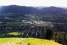 | ||||||||||
|---|---|---|---|---|---|---|---|---|---|---|---|---|
| Geography |
| |||||||||||
| History |
| |||||||||||
| Media |
| |||||||||||
| Breweries | ||||||||||||
| Services |
| |||||||||||
| Sports |
| |||||||||||
| University of Montana | ||||||||||||
| ||||||||||||
Municipalities and communities of Missoula County, Montana, United States | ||
|---|---|---|
| City | 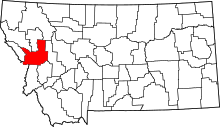 | |
| CDPs | ||
| Unincorporated communities | ||
| Ghost towns | ||
| Indian reservation | ||
| Footnotes | ‡This populated place also has portions in an adjacent county or counties | |