Watertown (town), New York
| Watertown, New York | |
|---|---|
| Town | |
 Watertown, New York Location within the state of New York | |
| Coordinates: 43°56′10″N 75°55′29″W / 43.93611°N 75.92472°WCoordinates: 43°56′10″N 75°55′29″W / 43.93611°N 75.92472°W | |
| Country | United States |
| State | New York |
| County | Jefferson |
| Government | |
| • Type | Town Council |
| • Town Supervisor | Joel R. Bartlett (D) |
| • Town Council |
Members' List
|
| Area | |
| • Total | 36.1 sq mi (93.4 km2) |
| • Land | 36.0 sq mi (93.2 km2) |
| • Water | 0.1 sq mi (0.2 km2) |
| Elevation | 538 ft (164 m) |
| Population (2010) | |
| • Total | 4,470 |
| • Density | 124.4/sq mi (48.0/km2) |
| Time zone | Eastern (EST) (UTC-5) |
| • Summer (DST) | EDT (UTC-4) |
| ZIP codes | 13601-13603 |
| Area code(s) | 315 |
| FIPS code | 36-78619[1] |
| GNIS feature ID | 0979605[2] |
Watertown is a town in Jefferson County, New York, United States. The population is 4,470.
The Town of Watertown is located in the central part of the county. Part of the City of Watertown borders the town.
The area is served by Watertown International Airport, which is located west of the town and city in the Town of Hounsfield.
History
Numerous sites of the aboriginal habitation were found by early surveyors of this region. The region was later part of Macomb's Purchase.
Watertown was established as a town in 1800 before the formation of Jefferson County, while still in Oneida County, New York. The Towns of Rutland, New York (1802) and Hounsfield, New York (1806) were soon formed from part of Watertown.
The town was first settled in 1800 around the time of the first permanent US military presence in the region, which was established at nearby Sackets Harbor to guard the international border and to fight smuggling in the St. Lawrence region.
In 1816, the community of Watertown set itself off from the town by incorporating as a village. It became a city in 1869.
The John Losee House was added to the National Register of Historic Places in 2014.[3]
Geography
According to the United States Census Bureau, the Town has a total area of 36.1 square miles (93.4 km²), of which, 36.0 square miles (93.2 km²) of it is land and 0.1 square miles (0.2 km²) of it (0.19%) is water. The land area of the City, a separate political jurisdiction which borders the Town of Watertown, is 9.0 square miles (23 km2).
As of the 2010 Census, the population of the Town of Watertown was 4,470 and the population of the City of Watertown was 27,023. References to "Watertown, New York" usually apply to the city rather than to the town.
The Town of Watertown is located in central portion of Jefferson County, situated south of the Black River, which serves as the Town's northern boundary. The Town of Watertown is bordered to the north by the City of Watertown and the Towns of Brownville, Pamelia and Le Ray, to the east by the Town of Rutland, to the south by the Towns of Adams and Rodman, and to the west by the Town of Hounsfield.
Interstate 81 passes through the west part of the town. U.S. Route 11 is a north-south highway in through the town. New York State Route 3, New York State Route 12, New York State Route 12F, New York State Route 126, and New York State Route 232 are east-west highways through Watertown. Many of these highways converge in the City of Watertown.
Three full-power television stations WPBS, WWNY (CBS) and WWTI (ABC) currently serve the Watertown area.
Demographics
| Historical population | |||
|---|---|---|---|
| Census | Pop. | %± | |
| 1820 | 2,766 | — | |
| 1830 | 4,768 | 72.4% | |
| 1840 | 5,027 | 5.4% | |
| 1850 | 7,201 | 43.2% | |
| 1860 | 7,567 | 5.1% | |
| 1870 | 1,373 | −81.9% | |
| 1880 | 1,264 | −7.9% | |
| 1890 | 1,215 | −3.9% | |
| 1900 | 1,159 | −4.6% | |
| 1910 | 1,097 | −5.3% | |
| 1920 | 1,116 | 1.7% | |
| 1930 | 1,270 | 13.8% | |
| 1940 | 1,399 | 10.2% | |
| 1950 | 1,752 | 25.2% | |
| 1960 | 2,492 | 42.2% | |
| 1970 | 3,026 | 21.4% | |
| 1980 | 3,098 | 2.4% | |
| 1990 | 4,341 | 40.1% | |
| 2000 | 4,482 | 3.2% | |
| 2010 | 4,470 | −0.3% | |
| Est. 2014 | 4,601 | [4] | 2.9% |
As of the census[1] of 2000, there were 4,482 people, 1,407 households, and 1,018 families residing in the town. The population density was 124.6 people per square mile (48.1/km²). There were 1,502 housing units at an average density of 41.7 per square mile (16.1/km²). The racial makeup of the town was 83.94% White, 11.24% Black, 0.33% Native American, 0.60% Asian, 0.02% Pacific Islander, 3.39% from other races, and 0.47% from two or more races. Hispanic or Latino of any race were 6.85% of the population.
There were 1,407 households out of which 34.7% had children under the age of 18 living with them, 61.2% were married couples living together, 7.3% had a female householder with no husband present, and 27.6% were non-families. 22.4% of all households were made up of individuals and 9.5% had someone living alone who was 65 years of age or older. The average household size was 2.57 and the average family size was 3.02.
In the town the population was spread out with 21.3% under the age of 18, 6.8% from 18 to 24, 37.6% from 25 to 44, 24.4% from 45 to 64, and 9.9% who were 65 years of age or older. The median age was 37 years. For every 100 females there were 143.6 males. For every 100 females age 18 and over, there were 158.0 males.
The median income for a household in the town was $41,961, and the median income for a family was $46,563. Males had a median income of $35,475 versus $21,638 for females. The per capita income for the town was $21,786. About 3.8% of families and 4.7% of the population were below the poverty line, including 5.6% of those under age 18 and 1.7% of those age 65 or over.
Communities and locations in the Town of Watertown
- Burrville (formerly "Burrs Mills") – A hamlet near the east town line on NY-12. The name is from Captain John Burr and his family, early settlers. The community was an early rival for another community which became the City of Watertown.
- Dry Hill – A hamlet south of the City of Watertown and location of a skiing area. The name is based on the relatively low level of the water table in the area (making it very difficult to draw a successful water well in the area).
- East Watertown – A hamlet near the east town line on NY-126.
- Fields Settlement – A location at the west town line on County Road 63.
- Huntingtonville – A hamlet in the northeast corner of the town by the Black River. It is now a suburb of the city.
- North Watertown – A former location in the town, north of the Black River.
- Rices – A hamlet in the southeast part of the town on Route 232 by Interstate 81.
- Rices Junction – A location northeast of Rice on Route 232.
- Watertown – The City of Watertown borders the north central part of the town.
- Watertown Center – A hamlet on US 11 at County Road 116 south of the City of Watertown. Watertown Center is the location of the town government.
References
- 1 2 "American FactFinder". United States Census Bureau. Retrieved 2008-01-31.
- ↑ "US Board on Geographic Names". United States Geological Survey. 2007-10-25. Retrieved 2008-01-31.
- ↑ "National Register of Historic Places Listings". Weekly List of Actions Taken on Properties: 2/10/14 through 2/14/14. National Park Service. 2014-02-21.
- ↑ "Annual Estimates of the Resident Population for Incorporated Places: April 1, 2010 to July 1, 2014". Retrieved June 4, 2015.
- ↑ "Census of Population and Housing". Census.gov. Retrieved June 4, 2015.
External links
- Watertown, NY link
- Town of Watertown early history
- Jefferson County History with pics and links
- Watertown historical/genealogical links
- Jefferson County & Watertown wiki
- Jefferson County Breaking News and Information
Municipalities and communities of Jefferson County, New York, United States | ||
|---|---|---|
| City | 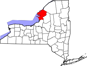 | |
| Towns | ||
| Villages | ||
| CDPs |
| |
| Hamlets | ||