Brownville, New York
| Brownville | |
| Town | |
| Country | United States |
|---|---|
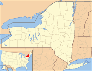
| State | New York |
| County | Jefferson |
| Coordinates | 44°00′08″N 75°58′59″W / 44.00222°N 75.98306°WCoordinates: 44°00′08″N 75°58′59″W / 44.00222°N 75.98306°W |
| Area | 66.6 sq mi (172.5 km2) |
| Population | 6,263 (2010) |
| Density | 94/sq mi (36.3/km2) |
| Town Supervisor | Leo K. Thompson (R) |
| - Town Council | |
| Timezone | EST (UTC-5) |
| - summer (DST) | EDT (UTC-4) |
| ZIP code | 13615 |
| Area code | 315 |
 Location of Brownville in New York
| |
Brownville is a town in Jefferson County, New York, USA. The population was 6,263 at the 2010 census. The town is named after Jacob Brown, early settler and leader.
The Town of Brownville is located in the western part of the county, northwest of Watertown. The town contains a village also named Brownville.
History
The Oneida tribe claim to be the original inhabitants of the area.
The town was settled around 1799 near Brownville village. It was one of the first towns in the county. Its name is derived from the founder and first settler, Jacob Brown, who was a prominent figure as major-general in the United States Army and is considered to be a heroic figure in the War of 1812.
The town was formed in 1802 while still part of Herkimer County.
Many of the northern towns of the county were established, or partly established, from parts of Brownville, including Le Ray (1806), Lyme (1818), Pamelia (1819), Orleans (1821), and Alexandria (1821).
In 1828, the community of Brownville set itself off from the town by incorporating as a village.
In 1855, the community of Dexter set itself off from the town by incorporating as a village.
The William Archer House, Gen. Jacob Brown Mansion, Brownville Hotel, St. Paul's Church, Vogt House, and Arthur Walrath House are listed on the National Register of Historic Places.[1]
Geography
According to the United States Census Bureau, the town has a total area of 66.6 square miles (172.5 km²), of which, 59.3 square miles (153.6 km²) of it is land and 7.3 square miles (19.0 km²) of it (10.99%) is water.
The west border of the town is Lake Ontario and the south border is formed by the Black River, which flows into the lake at Black River Bay. The Perch River flows through the town from the northeast corner to the southeast corner and Lake Ontario.
New York State Route 12E is an east-west highway, which intersects New York State Route 180, a north-south highway, at Limerick. New York State Route 12 crosses the northeast corner of the town.
Demographics
| Historical population | |||
|---|---|---|---|
| Census | Pop. | %± | |
| 1820 | 3,990 | — | |
| 1830 | 2,938 | −26.4% | |
| 1840 | 3,968 | 35.1% | |
| 1850 | 4,282 | 7.9% | |
| 1860 | 3,966 | −7.4% | |
| 1870 | 3,219 | −18.8% | |
| 1880 | 2,624 | −18.5% | |
| 1890 | 3,110 | 18.5% | |
| 1900 | 3,693 | 18.7% | |
| 1910 | 3,615 | −2.1% | |
| 1920 | 3,856 | 6.7% | |
| 1930 | 3,489 | −9.5% | |
| 1940 | 3,671 | 5.2% | |
| 1950 | 3,806 | 3.7% | |
| 1960 | 3,985 | 4.7% | |
| 1970 | 4,321 | 8.4% | |
| 1980 | 5,113 | 18.3% | |
| 1990 | 5,604 | 9.6% | |
| 2000 | 5,839 | 4.2% | |
| 2010 | 6,263 | 7.3% | |
| Est. 2014 | 6,475 | [2] | 3.4% |
As of the census[4] of 2000, there were 5,843 people, 2,184 households, and 1,633 families residing in the town. The population density was 98.5 people per square mile (38.0/km²). There were 2,857 housing units at an average density of 48.2 per square mile (18.6/km²). The racial makeup of the town was 97.84% White, 0.27% Black or African American, 0.55% Native American, 0.27% Asian, 0.02% Pacific Islander, 0.27% from other races, and 0.77% from two or more races. Hispanic or Latino of any race were 0.58% of the population.
There were 2,184 households out of which 37.3% had children under the age of 18 living with them, 60.3% were married couples living together, 10.5% had a female householder with no husband present, and 25.2% were non-families. 20.5% of all households were made up of individuals and 9.1% had someone living alone who was 65 years of age or older. The average household size was 2.66 and the average family size was 3.07.
In the town the population was spread out with 27.3% under the age of 18, 6.8% from 18 to 24, 29.2% from 25 to 44, 23.8% from 45 to 64, and 12.8% who were 65 years of age or older. The median age was 38 years. For every 100 females there were 93.1 males. For every 100 females age 18 and over, there were 91.9 males.
The median income for a household in the town was $38,277, and the median income for a family was $43,866. Males had a median income of $33,889 versus $21,904 for females. The per capita income for the town was $16,303. About 6.0% of families and 8.2% of the population were below the poverty line, including 5.5% of those under age 18 and 11.3% of those age 65 or over.
Communities and locations in the Town of Brownville
- Adams Cove – A hamlet on the north shore of Pillar Point peninsula.
- Brownville – The Village of Brownville is in the south part of the town on NY-12E by the Black River.
- Bull Rock Point – A projection into Lake Ontario at the west end of Pillar Point peninsula.
- Dexter – The Village of Dexter is in the south part of the town on NY-180 and is west of Brownville village. It was formerly known as "Fish Island."
- Everleigh Point – A projection into Lake Ontario at the west end of Pillar Point peninsula.
- Glen Park – Part of the Village of Glen Park is on the south border of the town on NY-12E.
- Guffin Bay – A bay of Lake Ontario in the northwest part of Brownville.
- Limerick – A hamlet at the junction of Routes NY-12E and NY-180 by the Perch River, north of Dexter village.
- Natural Bridge – A location on the Perch River, southwest of Limerick.
- Paddy Hill – A hamlet south of Brownville by the south town line.
- Perch Lake – A lake in the northeast corner of Brownville.
- Perch River – A hamlet on NY-180 in the north part of the town near the stream called Perch River. The community was once called "Moffatsville."
- Perch River State Wildlife Area – A conservation area located in the northeast part of the town by Perch Lake.
- Pillar Point – (1) A peninsula into Lake Ontario in the western part of the town, and also, (2) a western projection into the lake on the end of the peninsula.
- Pillar Point Village – A hamlet on the south coast of Pillar Point peninsula, located on County Route 59.
- Reynolds Corner – A location near the north town line on County Road 125.
References
- ↑ National Park Service (2010-07-09). "National Register Information System". National Register of Historic Places. National Park Service.
- ↑ "Annual Estimates of the Resident Population for Incorporated Places: April 1, 2010 to July 1, 2014". Retrieved June 4, 2015.
- ↑ "Census of Population and Housing". Census.gov. Archived from the original on May 11, 2015. Retrieved June 4, 2015.
- ↑ "American FactFinder". United States Census Bureau. Archived from the original on 2013-09-11. Retrieved 2008-01-31.
External links
Municipalities and communities of Jefferson County, New York, United States | ||
|---|---|---|
| City | 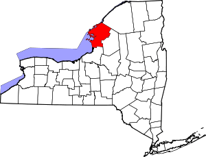 | |
| Towns | ||
| Villages | ||
| CDPs |
| |
| Hamlets | ||