Rodman, New York
| Rodman, New York | |
|---|---|
| Town | |
 Rodman, New York Location within the state of New York | |
| Coordinates: 43°51′3″N 75°54′56″W / 43.85083°N 75.91556°W | |
| Country | United States |
| State | New York |
| County | Jefferson |
| Government | |
| • Type | Town Council |
| • Town Supervisor | Gary R. Stinson (R) |
| • Town Council |
Members' List
|
| Area | |
| • Total | 42.3 sq mi (109.4 km2) |
| • Land | 42.2 sq mi (109.4 km2) |
| • Water | 0.0 sq mi (0.0 km2) |
| Elevation | 899 ft (274 m) |
| Population (2010) | |
| • Total | 1,176 |
| • Density | 27.8/sq mi (10.7/km2) |
| Time zone | Eastern (EST) (UTC-5) |
| • Summer (DST) | EDT (UTC-4) |
| ZIP code | 13682 |
| Area code(s) | 315 |
| FIPS code | 36-63341 |
| GNIS feature ID | 0979429 |
Rodman is a town in Jefferson County, New York, United States. The population was 1,176 at the 2010 census. The name is derived from a public official, Daniel Rodman.
The Town of Rodman is at the southeastern border of the county and is south of Watertown.
History
Prehistoric remains in the town document the lives of the original natives.
The region was part of Macomb's Purchase. The town was first settled around 1801.
Rodman was organized as a town in 1804 from part of the Town of Adams. The town was originally called "Harrison" after an early landowner, but was later changed to "Rodman," the name of the clerk of the legislature, due to confusion with other similarly named communities. Part of Rodman was used in 1808 to form the Town of Pinckney (Now part of Lewis County).
Residents of note
- Rodman native Benjamin Burr (1818-1894) served in the Wisconsin State Assembly and was a businessman in Stevens Point, Wisconsin.
- Rodman native Adele M. Fielde (1839–1916) became a Baptist missionary in China. She wrote books about China, parliamentary procedure, and the Swatow dialect.
- Rodman native Frank Winfield Woolworth (1852-1919) made a fortune from his "five and dime" mercantile empire.
Geography
According to the United States Census Bureau, the town has a total area of 42.3 square miles (110 km2), of which, 42.2 square miles (109 km2) of it is land and 0.02% is water.
The town is north of Syracuse, New York and south of the City of Watertown. The eastern town line is the border of Lewis County.
New York State Route 177 is an east-west highway crossing the town.
The South Branch of Sandy Creek runs through Rodman, NY and eventually ends up joining the North Branch of Sandy Creek under Litt's Bridge.
Demographics
| Historical population | |||
|---|---|---|---|
| Census | Pop. | %± | |
| 1820 | 1,735 | — | |
| 1830 | 1,901 | 9.6% | |
| 1840 | 1,702 | −10.5% | |
| 1850 | 1,784 | 4.8% | |
| 1860 | 1,808 | 1.3% | |
| 1870 | 1,604 | −11.3% | |
| 1880 | 1,517 | −5.4% | |
| 1890 | 1,287 | −15.2% | |
| 1900 | 1,212 | −5.8% | |
| 1910 | 1,123 | −7.3% | |
| 1920 | 1,027 | −8.5% | |
| 1930 | 935 | −9.0% | |
| 1940 | 856 | −8.4% | |
| 1950 | 816 | −4.7% | |
| 1960 | 765 | −6.2% | |
| 1970 | 772 | 0.9% | |
| 1980 | 836 | 8.3% | |
| 1990 | 1,016 | 21.5% | |
| 2000 | 1,149 | 13.1% | |
| 2010 | 1,176 | 2.3% | |
| Est. 2014 | 1,215 | [1] | 3.3% |
As of the census[3] of 2000, there were 1,147 people, 385 households, and 314 families residing in the town. The population density was 27.2 people per square mile (10.5/km²). There were 455 housing units at an average density of 10.8 per square mile (4.2/km²). The racial makeup of the town was 98.34% White, 0.17% African American, 0.61% Native American, 0.09% from other races, and 0.78% from two or more races. Hispanic or Latino of any race were 1.39% of the population.
There were 385 households out of which 46.5% had children under the age of 18 living with them, 69.1% were married couples living together, 6.0% had a female householder with no husband present, and 18.2% were non-families. 13.5% of all households were made up of individuals and 5.7% had someone living alone who was 65 years of age or older. The average household size was 2.98 and the average family size was 3.26.
In the town the population was spread out with 30.9% under the age of 18, 8.0% from 18 to 24, 31.3% from 25 to 44, 21.3% from 45 to 64, and 8.5% who were 65 years of age or older. The median age was 35 years. For every 100 females there were 110.1 males. For every 100 females age 18 and over, there were 107.0 males.
The median income for a household in the town was $36,339, and the median income for a family was $43,750. Males had a median income of $28,750 versus $25,764 for females. The per capita income for the town was $15,453. About 6.7% of families and 9.5% of the population were below the poverty line, including 11.6% of those under age 18 and 5.2% of those age 65 or over.
Communities and locations in Rodman
- Babbits Corners – A location in the southeast part of the town at the junction of NY-177 and County Road 189.
- Dillen – A hamlet in the northeast corner of the town on County Road 155.
- East Rodman – A hamlet near the eastern town line on County Roads 69 and 156. It was also called "Whitesville."
- Rodman – The hamlet of Rodman is at the junction of County Roads 69 and 97 in the west-central part of the town.
- Ross Corners – A location in the southwest part of the town on County Road 97.
- Shingle Gulf – A canyon in the northeast part of Rodman.
- Tremaines Corners – A hamlet near the center of the town on County Roads 95 and 177.
- West Rodman – A former location in the town.
- Whitford Corners – A location in the northwest part of the town on NY-177. The location was also called "West Rodman" and "Toad Hollow."
- Zoar – A hamlet northeast of Rodman village, formerly known as "Unionville."
References
- ↑ "Annual Estimates of the Resident Population for Incorporated Places: April 1, 2010 to July 1, 2014". Retrieved June 4, 2015.
- ↑ "Census of Population and Housing". Census.gov. Retrieved June 4, 2015.
- ↑ "American FactFinder". United States Census Bureau. Retrieved 2008-01-31.
External links
Coordinates: 43°51′04″N 75°56′27″W / 43.85111°N 75.94083°W
Municipalities and communities of Jefferson County, New York, United States | ||
|---|---|---|
| City | 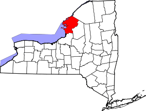 | |
| Towns | ||
| Villages | ||
| CDPs |
| |
| Hamlets | ||