Thouaré-sur-Loire
| Thouaré-sur-Loire | ||
|---|---|---|
|
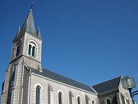
The church of Saint-Vincent | ||
| ||
 Thouaré-sur-Loire | ||
|
Location within Pays de la Loire region  Thouaré-sur-Loire | ||
| Coordinates: 47°16′06″N 1°26′22″W / 47.2683°N 1.4394°WCoordinates: 47°16′06″N 1°26′22″W / 47.2683°N 1.4394°W | ||
| Country | France | |
| Region | Pays de la Loire | |
| Department | Loire-Atlantique | |
| Arrondissement | Nantes | |
| Canton | Carquefou | |
| Government | ||
| • Mayor | Bernard Chesneau | |
| Area1 | 12.76 km2 (4.93 sq mi) | |
| Population (2007)2 | 7,449 | |
| • Density | 580/km2 (1,500/sq mi) | |
| Time zone | CET (UTC+1) | |
| • Summer (DST) | CEST (UTC+2) | |
| INSEE/Postal code | 44204 / 44470 | |
| Elevation |
1–73 m (3.3–239.5 ft) (avg. 13 m or 43 ft) | |
|
1 French Land Register data, which excludes lakes, ponds, glaciers > 1 km² (0.386 sq mi or 247 acres) and river estuaries. 2 Population without double counting: residents of multiple communes (e.g., students and military personnel) only counted once. | ||
.svg.png)
Thouaré-sur-Loire (Breton “Tarvieg”) is a commune in the Loire-Atlantique department in western France.
Origin of the name
The origins of Thouaré are not certain. According to certain hypotheses, the foundation of the city was due to a Roman legionnaire by the name of Taurus or Tauraicus, who had been given a rich villa in the area. Another is that it is due to a Celtic god, worshipped in this part of Gaul, by the name of Taur.
The name of Thouaré appears for the first time in the chart of Louis le Gros in 1123. His orthography differs due to successive editors: Thoaré, Thoyré, Touaré, Thoaret, Thoairé, then finally Thouaré.
See also
| Wikimedia Commons has media related to Thouaré-sur-Loire. |
This article is issued from Wikipedia - version of the 2/6/2015. The text is available under the Creative Commons Attribution/Share Alike but additional terms may apply for the media files.