Sautron
| Sautron | |
|---|---|
|
L'hôtel de ville. | |
 Sautron | |
|
Location within Pays de la Loire region  Sautron | |
| Coordinates: 47°15′52″N 1°40′00″W / 47.2644°N 1.6667°WCoordinates: 47°15′52″N 1°40′00″W / 47.2644°N 1.6667°W | |
| Country | France |
| Region | Pays de la Loire |
| Department | Loire-Atlantique |
| Arrondissement | Nantes |
| Canton | Orvault |
| Intercommunality | Nantes Métropole |
| Government | |
| • Mayor (2008–2014) | Marie-Cécile Gessant |
| Area1 | 17.28 km2 (6.67 sq mi) |
| Population (2006)2 | 6,809 |
| • Density | 390/km2 (1,000/sq mi) |
| Time zone | CET (UTC+1) |
| • Summer (DST) | CEST (UTC+2) |
| INSEE/Postal code | 44194 / 44880 |
| Elevation | 25–80 m (82–262 ft) |
| Website | http://www.sautron.fr/ |
|
1 French Land Register data, which excludes lakes, ponds, glaciers > 1 km² (0.386 sq mi or 247 acres) and river estuaries. 2 Population without double counting: residents of multiple communes (e.g., students and military personnel) only counted once. | |

| Wikimedia Commons has media related to Sautron. |
Sautron is a commune in the Loire-Atlantique département in western France.
Geography

Position of Sautron in the département of Loire-Atlantique
Sautron is located 10 km north west of Nantes, close to the Nantes-Vannes expressway.
Surrounding communes are Vigneux-de-Bretagne, Orvault, Saint-Herblain and Couëron.
According to the classification established by INSEE, Sautron is a commune urbaine (urban commune), one of 19 communes in the suburban area of Nantes.
Sites and monuments
 The church
 The Château des Croix
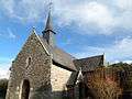 Chapelle de Bongarant
See also
External links
- Website of the Commune of Sautron
- Sautron on the Institut Géographique National website
- Sautron on the INSEE website
This article is issued from Wikipedia - version of the 1/3/2014. The text is available under the Creative Commons Attribution/Share Alike but additional terms may apply for the media files.