Herbignac
| Herbignac | ||
|---|---|---|
|
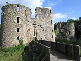
The main entrance of the Château de Ranrouët, in Herbignac | ||
| ||
 Herbignac | ||
|
Location within Pays de la Loire region  Herbignac | ||
| Coordinates: 47°26′59″N 2°18′58″W / 47.4497°N 2.3161°WCoordinates: 47°26′59″N 2°18′58″W / 47.4497°N 2.3161°W | ||
| Country | France | |
| Region | Pays de la Loire | |
| Department | Loire-Atlantique | |
| Arrondissement | Saint-Nazaire | |
| Canton | Herbignac | |
| Intercommunality | Cap Atlantique | |
| Government | ||
| • Mayor (2008–2014) | Pascal Noël-Racine | |
| Area1 | 71.43 km2 (27.58 sq mi) | |
| Population (1999)2 | 4,353 | |
| • Density | 61/km2 (160/sq mi) | |
| Time zone | CET (UTC+1) | |
| • Summer (DST) | CEST (UTC+2) | |
| INSEE/Postal code | 44072 / 44410 | |
| Elevation |
0–55 m (0–180 ft) (avg. 15 m or 49 ft) | |
|
1 French Land Register data, which excludes lakes, ponds, glaciers > 1 km² (0.386 sq mi or 247 acres) and river estuaries. 2 Population without double counting: residents of multiple communes (e.g., students and military personnel) only counted once. | ||
.svg.png)
Herbignac is a commune in the Loire-Atlantique department in western France.
See also
- Château de Ranrouët
- La Baule - Guérande Peninsula
- Communes of the Loire-Atlantique department
- Parc naturel régional de Brière
External links
| Wikimedia Commons has media related to Herbignac. |
- Official Web site (French)
This article is issued from Wikipedia - version of the 2/11/2016. The text is available under the Creative Commons Attribution/Share Alike but additional terms may apply for the media files.