Paimbœuf
| Paimbœuf | ||
|---|---|---|
|
The town hall in Paimbœuf | ||
| ||
 Paimbœuf | ||
|
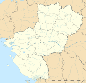
Location within Pays de la Loire region  Paimbœuf | ||
| Coordinates: 47°17′00″N 2°02′00″W / 47.2833°N 2.0333°WCoordinates: 47°17′00″N 2°02′00″W / 47.2833°N 2.0333°W | ||
| Country | France | |
| Region | Pays de la Loire | |
| Department | Loire-Atlantique | |
| Arrondissement | Saint-Nazaire | |
| Canton | Paimboeuf | |
| Intercommunality | Sud-Estuaire | |
| Government | ||
| • Mayor (2008–2014) | Michel Bahurel (PS) | |
| Area1 | 2 km2 (0.8 sq mi) | |
| Population (2006)2 | 3,054 | |
| • Density | 1,500/km2 (4,000/sq mi) | |
| Time zone | CET (UTC+1) | |
| • Summer (DST) | CEST (UTC+2) | |
| INSEE/Postal code | 44116 / 44560 | |
| Elevation | 0–11 m (0–36 ft) | |
| Website | http://www.paimboeuf.fr/ | |
|
1 French Land Register data, which excludes lakes, ponds, glaciers > 1 km² (0.386 sq mi or 247 acres) and river estuaries. 2 Population without double counting: residents of multiple communes (e.g., students and military personnel) only counted once. | ||
Paimbœuf is a commune in the Loire-Atlantique department in western France, lying on the south bank of the River Loire upriver from St Nazaire but considerably downriver from Nantes. In the Napoleonic era it was the site of considerable naval shipbuilding. The United States Navy established a naval air station there on 1 March 1918 to operate dirigibles during World War I. The base closed shortly after the First Armistice at Compiègne.[1]
See also
References
- ↑ Van Wyen, Adrian O. (1969). Naval Aviation in World War I. Washington, D.C.: Chief of Naval Operations. p. 61.
| Wikimedia Commons has media related to Paimbœuf. |
This article is issued from Wikipedia - version of the 8/27/2015. The text is available under the Creative Commons Attribution/Share Alike but additional terms may apply for the media files.
.jpg)
.svg.png)