Noyal-sur-Brutz
| Noyal-sur-Brutz | ||
|---|---|---|
|
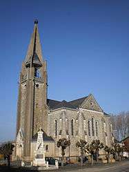
The church of Saint-Martin, in Noyal-sur-Brutz | ||
| ||
 Noyal-sur-Brutz | ||
|
Location within Pays de la Loire region  Noyal-sur-Brutz | ||
| Coordinates: 47°46′37″N 1°20′44″W / 47.7769°N 1.3456°WCoordinates: 47°46′37″N 1°20′44″W / 47.7769°N 1.3456°W | ||
| Country | France | |
| Region | Pays de la Loire | |
| Department | Loire-Atlantique | |
| Arrondissement | Châteaubriant | |
| Canton | Rougé | |
| Intercommunality | Castelbriantais | |
| Government | ||
| • Mayor (2008–2014) | Francis Martin | |
| Area1 | 7.71 km2 (2.98 sq mi) | |
| Population (2006)2 | 529 | |
| • Density | 69/km2 (180/sq mi) | |
| Time zone | CET (UTC+1) | |
| • Summer (DST) | CEST (UTC+2) | |
| INSEE/Postal code | 44112 / 44110 | |
| Elevation | 64–112 m (210–367 ft) | |
| Website | www.cc-castelbriantais.fr | |
|
1 French Land Register data, which excludes lakes, ponds, glaciers > 1 km² (0.386 sq mi or 247 acres) and river estuaries. 2 Population without double counting: residents of multiple communes (e.g., students and military personnel) only counted once. | ||
.svg.png)
Noyal-sur-Brutz is a commune in the Loire-Atlantique department in western France.
Geography
The village lies above the left bank of the river Brutz (a tributary of the Semnon), which flows westward through the northern part of the commune.
The river Verzée forms part of the commune's southern border.
See also
| Wikimedia Commons has media related to Noyal-sur-Brutz. |
This article is issued from Wikipedia - version of the 2/11/2016. The text is available under the Creative Commons Attribution/Share Alike but additional terms may apply for the media files.