Texas State Highway 16
| |||||||
|---|---|---|---|---|---|---|---|
 | |||||||
| Route information | |||||||
| Maintained by TxDOT | |||||||
| Length: | 541.8 mi[1] (871.9 km) | ||||||
| Existed: | before 1939 – present | ||||||
| Major junctions | |||||||
| South end: |
| ||||||
|
| |||||||
| North end: |
| ||||||
| Highway system | |||||||
| |||||||

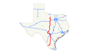
State Highway 16, or SH 16, is a south–north state highway that runs from Zapata on the Texas-Mexico boundary to U.S. Highway 281 24 miles (38.6 km) south of Wichita Falls. It is the longest state highway in Texas at almost 542 miles, but is only the 9th longest highway overall in the state.[2]
Route description
SH 16 begins at an intersection at US 83 in Zapata. The route continues through south Texas ranchlands, then to the north through San Antonio's far south side. The routes enters San Antonio from the southeast, and goes around the west side of the city concurrent with Interstate 410. The route veers to the northwest as it passes through Bandera, Kerrville, and Fredericksburg, and then reaches the Texas Hill Country. After passing through the cities of Comanche and Llano, it continues north through ranchland and farms. Its next intersection is with I-20 south of the town of Strawn. It continues to the northwest, wrapping around the northern and eastern sides of Possum Kingdom Lake. It reaches an intersection with US 380 in the town of Graham. In North Texas, the highway finally reaches its final terminus between Antelope and Windthorst, almost 542 miles from its starting point.
Previous routes

SH 16 was one of the original twenty six state highways proposed in 1917, overlaid on top of the Fort Worth-Oklahoma Highway. From 1917 the routing mostly followed present day Interstate 35W from Fort Worth to Denton. It continued on, routed along present day Interstate 35 from Fort Worth through to Oklahoma. By 1919, the route was cancelled. It was then reassigned to the future route of U.S. Highway 181 (which was routed over it in 1926) from San Antonio to Corpus Christi. SH 16 then went west on SH 44 to Robstown, south on U.S. Highway 77, and west on SH 285. This route replaced portions of SH 9 and SH 12. It was reassigned by 1932 to a new section between Santa Anna and Brady over previous SH 107 and was rerouted over SH 51 from Crowell to the Oklahoma State line. By 1939, the section from Brady to Santa Anna was promptly reassigned to U.S. Highway 183.
SH 16 was designated by 1939 from south of Graham to near Buena Vista south of San Antonio, replacing SH 81. In 1965 the road was significantly extended via its current routing to Zapata, replacing State Highway 346 from San Antonio to Jourdanton, and was rerouted over Interstate 410 in San Antonio. SH 16 also replaced portions of SH 173 and FM 496.[3] In 1969, SH 16 extended north to US 281, replacing portions of SH 254 and FM 61.
Major intersections
| County | Location | mi | km | Destinations | Notes | ||
|---|---|---|---|---|---|---|---|
| Zapata | Zapata | ||||||
| Jim Hogg | | South end of FM 649 overlap | |||||
| Randado | North end of FM 649 overlap | ||||||
| South Fork Estates | |||||||
| Hebbronville | |||||||
| South end of SH 359 overlap | |||||||
| North end of SH 359 overlap | |||||||
| Duval | | ||||||
| | |||||||
| Freer | Future I-69W | ||||||
| | |||||||
| McMullen | | ||||||
| | |||||||
| Tilden | South end of SH 72 overlap | ||||||
| | North end of SH 72 overlap | ||||||
| | |||||||
| | |||||||
| Atascosa | | ||||||
| | |||||||
| Jourdanton | |||||||
| | |||||||
| | |||||||
| | |||||||
| Poteet | |||||||
| South end of FM 476 overlap | |||||||
| North end of FM 476 overlap | |||||||
| Bexar | San Antonio | interchange | |||||
| Watson Road / Lone Star Pass - Toyota Plant | former Spur 66 east | ||||||
| South end of I-410 / SH 130 overlap; SH 16 south follows exit 49 | |||||||
| see I-410 | |||||||
| Interchange; north end of I-410 overlap; SH 16 north follows exit 13 | |||||||
| Leon Valley | Wurzbach Road | ||||||
| former FM 471 south | |||||||
| San Antonio | Eckhert Road | former FM 1517 east | |||||
| interchange | |||||||
| Helotes | South end of FM 1560 overlap | ||||||
| North end of FM 1560 overlap | |||||||
| San Geronimo | |||||||
| Medina | | ||||||
| Bandera | | ||||||
| Pipe Creek | |||||||
| Bandera | South end of SH 173 overlap | ||||||
| North end of SH 173 overlap | |||||||
| | |||||||
| | |||||||
| Medina | |||||||
| | |||||||
| Kerr | | ||||||
| | |||||||
| Kerrville | |||||||
| I-10 exit 508 | |||||||
| Gillespie | Fredericksburg | ||||||
| South end of US 87 / US 290 overlap | |||||||
| North end of US 87 / US 290 overlap | |||||||
| Eckert | |||||||
| Llano | | ||||||
| Llano | |||||||
| South end of SH 71 overlap | |||||||
| North end of SH 71 overlap | |||||||
| San Saba | Cherokee | South end of RM 501 overlap | |||||
| North end of RM 501 overlap | |||||||
| San Saba | |||||||
| | |||||||
| | |||||||
| Mills | | ||||||
| Goldthwaite | south end of US 183 overlap | ||||||
| | south end of US 84 overlap | ||||||
| Durenville | north end of US 84 / US 183 overlap | ||||||
| | south end of FM 218 overlap | ||||||
| Priddy | north end of FM 218 overlap | ||||||
| Comanche | | ||||||
| | |||||||
| Comanche | |||||||
| | |||||||
| Downing | south end of FM 2318 overlap | ||||||
| north end of FM 2318 overlap | |||||||
| De Leon | |||||||
| south end of SH 6 overlap | |||||||
| north end of SH 6 overlap | |||||||
| | |||||||
| | |||||||
| Eastland | Desdemona | ||||||
| | I-20 exit 361 | ||||||
| Palo Pinto | Strawn | ||||||
| | |||||||
| Metcalf Gap | south end of US 180 overlap | ||||||
| Brad | north end of US 180 overlap | ||||||
| | |||||||
| | |||||||
| | |||||||
| | |||||||
| | |||||||
| | |||||||
| | |||||||
| Young | | ||||||
| Graham | |||||||
| south end of US 380 overlap | |||||||
| north end of US 380 overlap | |||||||
| | |||||||
| Loving | |||||||
| Markley | |||||||
| Archer | | ||||||
| 1.000 mi = 1.609 km; 1.000 km = 0.621 mi | |||||||
References
- ↑ Transportation Planning and Programming Division (n.d.). "State Highway No. 16". Highway Designation Files. Texas Department of Transportation. Retrieved August 7, 2013.
- ↑ "State Highway, Loop, and Spur Facts". Texas Department of Transportation. Retrieved August 7, 2013.
- ↑ Transportation Planning and Programming Division (n.d.). "State Highway No. 346". Highway Designation Files. Texas Department of Transportation. Retrieved August 7, 2013.